Description:
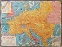
Toronto.: C.C. Petersen.. 1944.. Colour pictorial map, 51 x 67 cms, two small inset maps of Scandinavia and the Baltic and South Greece and the Dodecanese, on the verso a black and white world map showing the Pacific Theatre marking keys events of the war and in European world history, folding into the original pictorial pocket (a little toned and marked) 25.8 x 17.7 cms, small fold split, but in very good condition. A scarce map in the "Dated Events" series published by C.C. Petersen in Canada, and distributed throughout North America commemorating D-Day. The colour map by Stanley Turner encompasses the area from England as far south as the French border with Spain and as far east as the USSR and Turkey. "With this invasion map you will be able to follow the progress of the Allied troops on their way to smash Germany...". The text at lower left goes on to elaborate on the features shown on the map, from elevation ("major battles are seldom fought on the tops of mountains") to pictographs of bombs…
Read More Dated Events War Map. U. S. Invades Luzon Jan. 9-45 by WORLD WAR II) Turner, Stanley (cartography) - Map copyright 1942. Circa 1945.
by WORLD WAR II) Turner, Stanley (cartography)

Dated Events War Map. U. S. Invades Luzon Jan. 9-45
by WORLD WAR II) Turner, Stanley (cartography)
- Used
C.C. Petersen.. 23rd Edition.. Map copyright 1942. Circa 1945.. Color pictographic map, multiple fold as issued, approximately 17 1/4 x 38 3/4 inches. Very good condition. Colorful pictorial world map issued in many editions throughout the war by C.C. Petersen Advertising in Canada, and distributed by different companies in the U.S. and Canada, this by Walters Manufacturing Co. Throughout the map, significant events and dates of the War are noted. Includes inset maps: Closing in on Berlin, Balkan Countries, etc. .
-
Bookseller
Independent bookstores
 (US)
(US)
- Book Condition Used
- Edition 23rd Edition.
- Publisher C.C. Petersen.
- Date Published Map copyright 1942. Circa 1945.
- Keywords Asia, Europe, History, map, Military, pictographic map, pictorial map, World War II, zzephem, zzmapg, zzprintg
More Photos
Dated Events Invasion Map of Fortress Europe.
by [WORLD WAR II - MAP] TURNER, STANLEY (CARTOGRAPHER)
- Used
- Condition
- Used
- Quantity Available
- 1
- Seller
-
Canberra, Australian Capital Territory, Australia
- Item Price
-
$363.77
Show Details
Item Price
$363.77