Description:
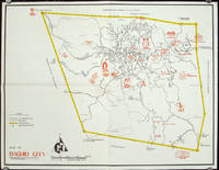
circa1960.. Printed pictorial map 44.8 x 58 cms, 46.7 x 60.3 cms (sheet), original folds (a little wear), but in very good condition. Attractive 1960s tourist map of Baguio city when it was the "Summer Capital" of the Philippines. Tourist attractions are shown pictorially in red, blue triangles denote wood carving shops, the city boundaries outlined in yellow, sealed and unsealed roads are also shown. .
Map of Baguio City Showing Some of Its Major and Minor Tourists Interests by PHILIPPINES) - No date. Ca. 1960s?
by PHILIPPINES)
Similar copies are shown below.
Similar copies are shown to the right.

Map of Baguio City Showing Some of Its Major and Minor Tourists Interests
by PHILIPPINES)
- Used
No date. Ca. 1960s?. Map, 17 1/2 x 23 on sheet size approximately 18 1/2 x 23 3/4 inches, two folds as issued. A few light soiled spots and soft creases; good condition. Scale 1:20,000 meters. Pictographs of places of interest, blue triangles denote wood carving shops. .
-
Bookseller
Independent bookstores
 (US)
(US)
- Book Condition Used
- Date Published No date. Ca. 1960s?
- Keywords ephemera, map, Philippines, pictographic map, zzephem, zzmapg
We have 1 copies available starting at $147.08.
Map of Baguio City Showing Some of Its Major and Minor Tourists Interests.
by [PHILIPPINES - 1960S TOURIST MAP]
- Used
- Condition
- Used
- Quantity Available
- 1
- Seller
-
Canberra, Australian Capital Territory, Australia
- Item Price
-
$147.08
Show Details
Item Price
$147.08