Description:
Paris: Jaillot, 1695. VG, with only flaw some dampstaining at lower margin with expert verso paper reinforcement, not affecting main image (would mat well). Centerfold as issued; hand-colored. A very uncommon and attractive plate, with a small walled city view (birds-eye) of Vienna, with all surrounding villages (castles) marked. A nice image of the Danube is central here. Jaillot was originally a sculptor (see Moreland & Bannister: Antique Maps). The copperplate image is 18x25.5 inches. .
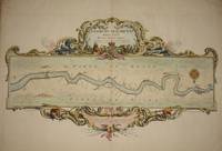
(Map / Chart Thames, Spanish Armada, Military History): Thamesis Descriptio Anno 1588. Roberto Adamo authore. Engraved from a copy drawn by Mr. Joseph Ames 8th April 1738 from the Original in Parchment by Pine, John (Adams, Robert) - 1740
by Pine, John (Adams, Robert)
(Map / Chart Thames, Spanish Armada, Military History): Thamesis Descriptio Anno 1588. Roberto Adamo authore. Engraved from a copy drawn by Mr. Joseph Ames 8th April 1738 from the Original in Parchment
by Pine, John (Adams, Robert)
- Used
- Hardcover
London: J. Pine , 1740. Very good condition, highly decorative chart with elaborate upper cartouche with armorial, lion and griffin. There is a lower cartouche, in the midline, with an English scale. This seems to be early color, on heavy laid paper, with nice margins, image measuring 15.75x26.5 inches. There are remnants of two small archival mounting stubs in the upper front corners, nowhere near the neatline and not constituting any serious visual distraction. This is a very uncommon chart from Pine's "The Tapestry Hangings of the House of Lords..", published in 1740 (a year later than the original compilation). The actual copyright date on this chart, in the right lower corner, is 1740. Pine's original publication had 10 sea coast chart, and this particular chart of the Thames was often missing, so this is a very uncommon and highly attractive item. Lord Effingham, commander of the British fleet that defeated the Armada, had commissioned Adams to produce this series of charts representing various battle phases. HC Vroom was commissioned to produce the original tapestry designs, which were woven by Francis Spiring of Harlem. Almost all the tapestries were burned in the Westminster Palace fire of 1834. London appears to the far right of the river chart, and there is a decorative 16 point compass rose just above the city location. The CD version of the DNB states: " In 1739 Pine published another work of great interest, entitled ‘The Tapestry Hangings of the House of Lords, representing the several engagements between the English and Spanish Fleets in the ever-memorable Year mdlxxxviii,’ with portraits, charts of the coasts of England, medals, &c. As these valuable tapestries, executed by H. C. Vroom to commemorate the defeat of the Spanish armada, were subsequently destroyed by fire, Pine's engravings, done from drawings by C. Lempriere, are of the greatest historical value.".
-
Bookseller
The Prime Meridian: Antique Maps & Books
 (US)
(US)
- Book Condition Used
- Quantity Available 1
- Binding Hardcover
- Publisher J. Pine
- Place of Publication London
- Date Published 1740
- Keywords Maps, Map, Sea Chart, Military History, England, Spanish Armada, John Pine, Cartography, Geography, Naval Battles

(Map / Chart- Environs of Vienna, Austria): Plan de la Ville De Vienne en Austriche et Ses Environs
by Jaillot, Alexis-Hubert
- Used
- Condition
- Used
- Binding
- Unknown
- Quantity Available
- 1
- Seller
-
Crozet, Virginia, United States
- Item Price
-
$595.00
Show Details
Item Price
$595.00

(Map of Holy Land- Canaan): Canaan
by Speed (Speede), John
- Used
- first
- Condition
- Used
- Binding
- Unknown
- Quantity Available
- 1
- Seller
-
Crozet, Virginia, United States
- Item Price
-
$1,495.00
Show Details
Description:
London: Christopher Browne (at the Globe near the West End of St. Pauls Church), 1695. Good, hand colored outlines, This is the Christopher Browne imprint (see Roderick M. Barron's description in his catalogue 33 as to the recent discovery of this imprint, separate from the more commonly reported Bassett and Chiswell 1676 plate), which may be more common than initially thought. Browne published a bit later, and had purchased the Bassett and Chiswell plates, then changed the name on a few of those (of which this plate was one; very few survive), and the date here is approximate. This is a striking image with Jerusalem inset, newly updated and published in the 1676 edition (date approximate) of Speed's " A Prospect of the Most Famous Parts of the World". There is some general browning, with some professional restorations at folds (virtually no image loss), mild upper margin staining (mostly in blank areas) and backed with Japon paper. A custom case was made for this map, after…
Read More Item Price
$1,495.00

(City / Town Plan - Toledo, Spain): Toletum
by Braun, Georg and Hogenberg, Franz
- Used
- Condition
- Used
- Binding
- Unknown
- Quantity Available
- 1
- Seller
-
Crozet, Virginia, United States
- Item Price
-
$1,800.00
Show Details
Description:
Braun & Hogenberg, 1598. Near fine, early color, latin edition (applicable text verso). Very decorative town plan of Toledo, Spain from this edition of the famous city atlas. Cherubim, palace, temple all present as separate images. These plans are well-known to collectors, and this particular item is increasingly uncommon. The full atlas was published in 6 volumes, in various editions, from 1572-1617. It was a collaborative work between many artists, engravers and cartographers (for a nice discussion of the history of this atlas, see Goss's THE MAPMAKERS ART, pp. 260-5). The map image measures 12.75x20 inches..
Item Price
$1,800.00

(Map of Pennsylvania): Geographical, Statistical, and Historical Map of Pennsylvania
by Carey & Lea (engr.by Young & Delleker)
- Used
- Hardcover
- first
- Condition
- Used
- Binding
- Hardcover
- Quantity Available
- 1
- Seller
-
Crozet, Virginia, United States
- Item Price
-
$400.00
Show Details
Description:
Philadelphia (Chestnut Street), 1822: HC Carey and I Lea, 1822. VG due to some minimal dampstaining most evident left upper corner, and minimally crossing neatline. The color portion of the map shows no significant visual effects from the stains. The original hand-colored image is clear and bright, with the surrounding letterpre ss text detailing aspects of population, climate, commerce, religion, government. There is a nice general historical sketch (in a separate page of original text, included here-- "Appendix to No. 18") in the letterpress. From the first edition "A Complete Historical, Chronological, and Geographical American Atlas...", which was also the first American atlas with letterpress printing on the map. This is a nice map, but for the defects described. The map image is 45x31cm; the entire image is 52.5x42cm..
Item Price
$400.00

(Map of Java/Borneo/Sumatra): Insulae Iavae Cum parte insularum Borneo Svmatrae et circumjacentium insularum novissima delineatio
by Jansson (Joannes Janssonius)
- Used
- Paperback
- Condition
- Used
- Binding
- Paperback
- Quantity Available
- 1
- Seller
-
Crozet, Virginia, United States
- Item Price
-
$875.00
Show Details
Description:
Jansson, c. 1657. Near-fine nicely colored (later) map with striking cartouche. Minor marginal soiling, no tears, 2 scales (Milliaria Germanica Communia and Milliaria Gallica Communia). Jansson was the son-in-law of Jodocus Hondius, and eventually managed their firm. Jansson eventually published an 11 volume Atlas Major (many of his maps were similar to, and prpbably copied from Blaeu's-- see Moreland & Bannister's ANTIQUE MAPS, 1989 edition). A beautiful map, 41.5x50.5cm..
Item Price
$875.00

(Map / Chart- Ottoman, Turkish Empire): Estats De L'Empire Du Grand Seigneur Des Turcs, En Europe, En Asie, et En Afrique, Divise En Touts Ses Beglerbeglicz, Ou Gouvernments
by Jaillot, Alexis-Hubert
- Used
- Condition
- Used
- Binding
- Unknown
- Quantity Available
- 1
- Seller
-
Crozet, Virginia, United States
- Item Price
-
$1,200.00
Show Details
Description:
Paris: H. Jaillot, 1695. VG, heavy paper, hand colored, decorative cartouche, inset of southern mediterranean / Algerian coast. A striking image, after Sanson and copied by several later cartographers. The above date is approximate, although clearly printed with the 5 scales indicated on the map.. Some browning and chipping of lower margin, not crossing neatline and easily covered by matting. This depicts the Ottoman (Turkish) Empire at the time, with its reaches through Asia, Europe and Africa. Includes environs of Mediterranean, Black, Red and Caspian Seas, with the "Golfe D'Ormus" at the western edge of the map. Includes details of Mediterranean with Cyprus, Rhodes, Candie, Sicily, Sardinia and Corsica, and much more. This is a very uncommon map, with the image measuring 18x25 inches (centerfold as issued)..
Item Price
$1,200.00
(Map of Holy Land- Canaan): Canaan
by Speed (Speede), John
- Used
- first
- Condition
- Used
- Binding
- Unknown
- Quantity Available
- 1
- Seller
-
Crozet, Virginia, United States
- Item Price
-
$1,495.00
Show Details
Description:
London: Christopher Browne (at the Globe near the West End of St. Pauls Church), 1695. Good, hand colored outlines, This is the Christopher Browne imprint (see Roderick M. Barron's description in his catalogue 33 as to the recent discovery of this imprint, separate from the more commonly reported Bassett and Chiswell 1676 plate), which may be more common than initially thought. Browne published a bit later, and had purchased the Bassett and Chiswell plates, then changed the name on a few of those (of which this plate was one; very few survive), and the date here is approximate. This is a striking image with Jerusalem inset, newly updated and published in the 1676 edition (date approximate) of Speed's " A Prospect of the Most Famous Parts of the World". There is some general browning, with some professional restorations at folds (virtually no image loss), mild upper margin staining (mostly in blank areas) and backed with Japon paper. A custom case was made for this map, after…
Read More Item Price
$1,495.00
(City / Town Plan - Toledo, Spain): Toletum
by Braun, Georg and Hogenberg, Franz
- Used
- Condition
- Used
- Binding
- Unknown
- Quantity Available
- 1
- Seller
-
Crozet, Virginia, United States
- Item Price
-
$1,800.00
Show Details
Description:
Braun & Hogenberg, 1598. Near fine, early color, latin edition (applicable text verso). Very decorative town plan of Toledo, Spain from this edition of the famous city atlas. Cherubim, palace, temple all present as separate images. These plans are well-known to collectors, and this particular item is increasingly uncommon. The full atlas was published in 6 volumes, in various editions, from 1572-1617. It was a collaborative work between many artists, engravers and cartographers (for a nice discussion of the history of this atlas, see Goss's THE MAPMAKERS ART, pp. 260-5). The map image measures 12.75x20 inches..
Item Price
$1,800.00
(Map of Pennsylvania): Geographical, Statistical, and Historical Map of Pennsylvania
by Carey & Lea (engr.by Young & Delleker)
- Used
- Hardcover
- first
- Condition
- Used
- Binding
- Hardcover
- Quantity Available
- 1
- Seller
-
Crozet, Virginia, United States
- Item Price
-
$400.00
Show Details
Description:
Philadelphia (Chestnut Street), 1822: HC Carey and I Lea, 1822. VG due to some minimal dampstaining most evident left upper corner, and minimally crossing neatline. The color portion of the map shows no significant visual effects from the stains. The original hand-colored image is clear and bright, with the surrounding letterpre ss text detailing aspects of population, climate, commerce, religion, government. There is a nice general historical sketch (in a separate page of original text, included here-- "Appendix to No. 18") in the letterpress. From the first edition "A Complete Historical, Chronological, and Geographical American Atlas...", which was also the first American atlas with letterpress printing on the map. This is a nice map, but for the defects described. The map image is 45x31cm; the entire image is 52.5x42cm..
Item Price
$400.00

(Celestial chart, lunar orbits and eclipses): Theoria Lunae, Eius Motum Per Eccentricum Et Epicyclum Demonstrans
by Valk, Gerard and Schenk, Petrus [Cellarius, Andreas]
- Used
- Condition
- Used
- Binding
- Unknown
- Quantity Available
- 1
- Seller
-
Crozet, Virginia, United States
- Item Price
-
$2,675.00
Show Details
Description:
Amsterdam: Schenk and Valk, 1708. Very good, minimal foxing, early color (with more recent enhancement) copperplate from this 1708 (original version published in 1660 by Jansson) Schenk/Valk issue of (Andreas Cellarius') "Harmonia Macrocosmica Seu Atlas Universalis Et Novus." The striking image measures 43 x 52 cm on a sheet 51 x 60 cm. Numerous cherubim surrond the circular view, as does an outer circle of a number of signs of the zodiac. There are a couple of pinhole defects, repaired verso, with no significant loss of imate. Ref: Koeman, Atlantes Neerlandici, Cel.3..
Item Price
$2,675.00

More Photos
The Princess Diaries 2 - Royal Engagement
by Hathaway, Anne & Julie Andrews & Hector Elizondo & John Rhys-Davies & Heather Matarazzo & Chris Pine & Callum Blue & Kathleen Marshall & Tom Poston & Joel McCrary & Kim Thomson & Raven & Spencer Breslin &
- Used
- very good
- Condition
- Used - Very Good
- ISBN 10 / ISBN 13
- 9780788854644 / 078885464X
- Quantity Available
- 1
- Seller
-
Hopkinsville, Kentucky, United States
- Item Price
-
$3.62$2.35Save $1.27!
Show Details
Description:
Walt Disney. Very Good. 2007. Dvd. 078885464X . DVD is in original package and in very good condition. Please see photographs submitted for your review.; Widescreen Edition; 0.7 X 7.5 X 5.4 inches .
Item Price
$3.62$2.35
Save $1.27
!

Stock Photo: Cover May Be Different
Technology in Emergency Management
by Pine, John C
- Used
- Condition
- Used - Good
- ISBN 10 / ISBN 13
- 9780471789734 / 0471789739
- Quantity Available
- 1
- Seller
-
Mishawaka, Indiana, United States
- Item Price
-
$7.36
Show Details
Description:
Wiley & Sons, Incorporated, John. Used - Good. Used book that is in clean, average condition without any missing pages.
Item Price
$7.36
Stock Photo: Cover May Be Different
Technology in Emergency Management
by Pine, John C
- Used
- Condition
- Used - Good
- ISBN 10 / ISBN 13
- 9780471789734 / 0471789739
- Quantity Available
- 1
- Seller
-
Mishawaka, Indiana, United States
- Item Price
-
$7.36
Show Details
Description:
Wiley & Sons, Incorporated, John. Used - Good. Former library book; may include library markings. Used book that is in clean, average condition without any missing pages.
Item Price
$7.36

199 Ways to Review a Book: Librarian's Readings in the Novel of the Sixties
by Pine, John C
- Used
- good
- Hardcover
- Condition
- Used - Good
- Binding
- Hardcover
- ISBN 10 / ISBN 13
- 9780810803657 / 0810803658
- Quantity Available
- 1
- Seller
-
Spring Branch, Texas, United States
- Item Price
-
$2.56
Show Details
Description:
Scarecrow Press, 1971-Aug-01. Hardcover. Good. 0x0x0. Ex-Library hardcover no dj (gray boards) with all the usual markings, attachments, and library wear. foxing to endpapers. Text block clean and unmarked. Tight binding.
Item Price
$2.56

Chinese camp and other California poems
by John C Pine
- Used
- Paperback
- Condition
- Used - Very Good+
- Jacket Condition
- None
- Binding
- Paperback
- ISBN 10 / ISBN 13
- 9780943430003 / 0943430003
- Quantity Available
- 1
- Seller
-
Syracuse, New York, United States
- Item Price
-
$4.00
Show Details
Description:
Moveable Feast Press. Trade Paperback. Very Good+/None. Few marks on covers; has publisher promotional materials laid-in ; trade pb size; 28 pages
Item Price
$4.00

Technology in Emergency Management
by John C. Pine
- Used
- very good
- Paperback
- Condition
- Used - Very Good
- Binding
- Paperback
- ISBN 10 / ISBN 13
- 9780471789734 / 0471789739
- Quantity Available
- 1
- Seller
-
Seattle, Washington, United States
- Item Price
-
$10.44
Show Details
Description:
Wiley & Sons, Incorporated, John, 2006. Paperback. Very Good. Disclaimer:May have limited writing in cover pages. Pages are unmarked. ~ ThriftBooks: Read More, Spend Less.Dust jacket quality is not guaranteed.
Item Price
$10.44

Stock Photo: Cover May Be Different
199 Ways to Review A Book
by Pine, John C
- Used
- Condition
- Used - Good
- ISBN 10 / ISBN 13
- 9780810803657 / 0810803658
- Quantity Available
- 1
- Seller
-
Mishawaka, Indiana, United States
- Item Price
-
$10.66
Show Details
Description:
Scarecrow Press, Incorporated. Used - Good. Former library book; may include library markings. Used book that is in clean, average condition without any missing pages.
Item Price
$10.66
Still Alive: New and Selected Poems.
by PINE, JOHN C
- Used
- first
- Condition
- Used
- Edition
- First edition.
- Quantity Available
- 1
- Seller
-
Berkeley, California, United States
- Item Price
-
$10.00
Show Details
Description:
El Dorado Hills: Moveable Feast Press,, 2001.. First edition.. 65 pp. Fine in glossy illustrated wrappers. Review slip laid in.
Item Price
$10.00
Columbiana: A Bibliography of Manuscripts, Pamphlets and Books Relating to the History of King’s College, Columbia College, Columbia University
by Nelson, Charles Alexander; Pine, John Buckley [Contributor]
- Used
- Paperback
- Condition
- Used: Good
- Binding
- Paperback
- Quantity Available
- 1
- Seller
-
HOUSTON, Texas, United States
- Item Price
-
$12.93
Show Details
Description:
Leopold Classic Library, 2018-02-06. Paperback. Used: Good.
Item Price
$12.93
Star Trek Into Darkness
by Chris Pine, Zachary Quinto, Karl Urban, Zoe Saldana, Simon Pegg, Anton Yelchin, John Cho, Benedict Cumberbatch, Peter Weller, Bruce Greenwood
- Used
- Condition
- Used - .1 DVD's
- Quantity Available
- 1
- Seller
-
Peoria, Illinois, United States
- Item Price
-
$9.00
Show Details
Description:
Paramount, 2013-09-10 00:00:00. DVD . .1 DVD's .
Item Price
$9.00

More Photos
The Sky and the Forest
by Forester, C.S
- Used
- very good
- Hardcover
- first
- Condition
- Used - Very Good
- Jacket Condition
- Very Good
- Edition
- First Edition
- Binding
- Hardcover
- Quantity Available
- 1
- Seller
-
Salem, Oregon, United States
- Item Price
-
$34.89$20.93Save $13.96!
Show Details
Description:
C.S. Forester: The Sky and the Forest. Little, Brown and Company, Boston. Stated First Edition First Printing Thus August, 1948. Cover price $2.75. Used. VG BOOK/VG UNCLIPPED DUST JACKET. A story of a central Africa. By C.S. Forester, author of the Admiral Hornblower series.
Item Price
$34.89$20.93
Save $13.96
!
![Alaska and Klondike Region; [With inset of Klondike Region on the Upper Yukon detail] [From an...](https://d3525k1ryd2155.cloudfront.net/h/062/537/1339537062.0.m.jpg)
Alaska and Klondike Region; [With inset of Klondike Region on the Upper Yukon detail] [From an atlas, "Gazetteer of Alaska and Yukon Region " pp. 105 and 106]
by Miller, J. Martin
- Used
- very good
- Condition
- Used - Very Good
- Edition
- Unknown
- Quantity Available
- 1
- Seller
-
Sebastopol, California, United States
- Item Price
-
$39.00
Show Details
Description:
Chicago: J. Martin Miller, 1899. Unknown. Map. Very Good. [Map copyright 1899, printing date of Atlas later] [19.875x15.125in]; Colored map of Alaska with steamer routes from Portland and Seattle, insets of the Klondike Region on the Upper Yukon and Western portion of Aleutian Islands; On verso index of places and names with two large black and white images; Age toning to all edges, water stain marks on bottom, slight printing offset of colors, small chips and closed tears to lower edge;.
Item Price
$39.00

Zemepis Sveta - Monsunova Asie
by De La Blache, P. Vidal; Gallois, L
- Used
- Hardcover
- Condition
- Used - Very Good Condition
- Jacket Condition
- No Dust Jacket
- Binding
- Hardcover
- Quantity Available
- 1
- Seller
-
Oak Point, Texas, United States
- Item Price
-
$60.00
Show Details
Description:
Aventinum, Prague, Czechoslovakia, 1931. Hardcover. Very Good Condition/No Dust Jacket. Text entirely in Czech. Geography book on Asia with numerous photographs and maps. 1930 edition also available. Size: 4mo - over 9 3/4" - 12" tall. 400 pp. Pages are yellowed, but are tight and clean. Moderate shelfwear along the spine. Corners are lightly bumped. Quantity Available: 1. Shipped Weight: 3-5 pounds. Category: Travel & Places; Non-English Language::Czech; Pictures of this item not already displayed here available upon request. Inventory No: 001228. . Additional shipping charges may apply.
Item Price
$60.00

Zemepis Sveta - Monsunova Asie
by De La Blache, P. Vidal; Gallois, L
- Used
- Hardcover
- Condition
- Used - Very Good Condition
- Jacket Condition
- No Dust Jacket
- Binding
- Hardcover
- Quantity Available
- 1
- Seller
-
Oak Point, Texas, United States
- Item Price
-
$60.00
Show Details
Description:
Aventinum, Prague, Czechoslovakia, 1930. Hardcover. Very Good Condition/No Dust Jacket. Text entirely in Czech. Geography book on Asia with numerous photographs and maps. 1931 edition also available. Size: 4mo - over 9 3/4" - 12" tall. 400 pp. Pages are yellowed, but are tight and clean. Moderate shelfwear along the spine. Corners are lightly bumped. Quantity Available: 1. Shipped Weight: 3-5 pounds. Category: Travel & Places; Non-English Language::Czech; Pictures of this item not already displayed here available upon request. Inventory No: 001227. . Additional shipping charges may apply.
Item Price
$60.00

North America from the Best Authorities, Russell, ca.1800
by Russell
- Used
- Condition
- Used
- Quantity Available
- 1
- Seller
-
Plymouth, Devon, United Kingdom
- Item Price
-
$25.12
Show Details
Description:
Russell, J. : A General Map of North America from the Best Authorities. Nd but ca.1800. From "A New Geographical, Historical and Commercial Grammar and Present State of Several Kingdoms of the World." Copper engraving. Size approx 200 x 230mm. Two neat folds. Some age colouring to edges, otherwise very clean and bright.
Item Price
$25.12

Asia from the Best Authorities, Russell, ca.1800
by Russell
- Used
- Condition
- Used
- Quantity Available
- 1
- Seller
-
Plymouth, Devon, United Kingdom
- Item Price
-
$25.12
Show Details
Description:
Russell, J. : Asia from the Best Authorities. Nd but ca.1800. From "A New Geographical, Historical and Commercial Grammar and Present State of Several Kingdoms of the World". Copper engraving. Size approx 200 x 230mm. Two neat folds. Some age colouring to edges, otherwise clean and bright. Includes Arabia, India, Borneo, Japan, China and eastern Russia.
Item Price
$25.12
![MAP OF UTAH [Territory]](https://d3525k1ryd2155.cloudfront.net/h/836/461/1485461836.0.m.jpg)
More Photos
MAP OF UTAH [Territory]
- Used
- Condition
- Used - Very Good-
- Edition
- Original
- Quantity Available
- 1
- Seller
-
Williamsburg, Virginia, United States
- Item Price
-
$65.00
Show Details
Description:
New York, Richmond, Chicago, & Toledo: H. H. Hardesty, 1885. Original color lithographed map printed by Rand, McNally & Company, Engravers and published in HARDESTY'S HISTORICAL AND GEOGRAPHICAL ENCYCLOPEDIA: SPECIAL VIRGINIA EDITION. 19 3/8 inches by 13 1/4 inches on a 21" X 14 1/2" sheet. The map depicts the Territory of Utah in its final form--large areas had been removed and ceded to Nevada, Colorado, Wyoming, and Nebraska since Utah became a U. S. Territory in 1850. The issue of polygamy prevented statehood until it was finally granted in 1896. This map features railroads and topography and uses color to set off counties from each other. Unlike most atlas maps of the period, this map identifies most small towns. The map is guaranteed to be moe than 135 years old. The map is in about very good condition: generally clean and bright, with slight toning of paper and one faint water stain near the center-left edge of the map.. Original. Single Sheet. Very Good-. Elephant…
Read More Item Price
$65.00

Philips Special Map of the Nile, The Advance on Khartum and the Environs of Omdurman. Cc1900
by George Philips and Son,
- Used
- Condition
- Used
- Quantity Available
- 1
- Seller
-
Plymouth, Devon, United Kingdom
- Item Price
-
$32.66
Show Details
Description:
Philips Special map of the Nile illustrating the Advance on Khartum [Khartoum] with an enlargement of the environs of Omdurman [Omdur]. George Philips and Son, London and Liverpool Ca 1900. 580mm x 900mm folded map. Front title wrapper has come loose, not affecting map area. Three maps are displayed within the sheet. Map1. Map of the Nile Valley 520mm x 300mm showing the approaches of Khartum. Scale 1inch to 100 Geographical miles. Coloured indicating Possessions and Protectorates of European Powers. Map 2. Special map of the Nile from Dongola to Khartum. Scale 16 miles to the inch. Coloured. In set in this map is Map3. Environs of Omdurman, Scale 5 statute miles to the inch. Some small breaks at some folds, not affecting imagery or use of map. Title label is damaged, the map is clean and bright, probably unused. A very interesting record.
Item Price
$32.66

Last Tales
by Dinesen, Isak
- Used
- very good
- Hardcover
- first
- Condition
- Used - Very Good
- Jacket Condition
- Good+
- Edition
- First Edition
- Binding
- Hardcover
- Quantity Available
- 1
- Seller
-
Salem, Oregon, United States
- Item Price
-
$120.00$72.00Save $48.00!
Show Details
Description:
Dinesen, Isak: Last Tales, A Collection of Twelve New Tales of Compelling Beauty 1957, Random House. First Edition. Stated First Printing Thus. Used. Very Good/Good+ original red dust jacket, price-clipped. Jacket states 11/57 on front flap. 5 3/4 X
Item Price
$120.00$72.00
Save $48.00
!

The Adventure of Wrangel Island
by Vilhjalmur Stefansson
- Used
- good
- Hardcover
- first
- Condition
- Used - Good
- Jacket Condition
- No DJ Included
- Edition
- First Edition
- Binding
- Hardcover
- Quantity Available
- 1
- Seller
-
Salem, Oregon, United States
- Item Price
-
$124.89$74.93Save $49.96!
Show Details
Description:
The Adventure of Wrangel Island, Alaska (1925 Macmillan 1st Edition) HISTORY OF ALASKA. EXLIB. Good Condition/ No DJ included. Fold-out map affixed to binding at the back of the book has never been opened. The story of the (unsuccessful) attempted colonization of Wrangel Island Alaska. 413 pages plus appendix, Index. Titling is still bright. A clean, solid copy. Scarce.
Item Price
$124.89$74.93
Save $49.96
!