Description:
Braun & Hogenberg, 1598. Near fine, early color, latin edition (applicable text verso). Very decorative town plan of Toledo, Spain from this edition of the famous city atlas. Cherubim, palace, temple all present as separate images. These plans are well-known to collectors, and this particular item is increasingly uncommon. The full atlas was published in 6 volumes, in various editions, from 1572-1617. It was a collaborative work between many artists, engravers and cartographers (for a nice discussion of the history of this atlas, see Goss's THE MAPMAKERS ART, pp. 260-5). The map image measures 12.75x20 inches..
(reduced version Fry-Jefferson Map of Virginia): Carte De La Virginie et Du Maryland Dressee...Mrs. Josue Fry et Pierre Jefferson, Par le Sr. Robert de Vaugondy Geographe Ordinaire du Roi by Robert de Vaugondy - 1755
by Robert de Vaugondy
Similar copies are shown below.
Similar copies are shown to the right.

(reduced version Fry-Jefferson Map of Virginia): Carte De La Virginie et Du Maryland Dressee...Mrs. Josue Fry et Pierre Jefferson, Par le Sr. Robert de Vaugondy Geographe Ordinaire du Roi
by Robert de Vaugondy
- Used
- very good
- first
Paris: Robert De Vaugondy, 1755. This is the second state (according to Verner, Imago Mundi 21:70-94, 1967) of the reduced single sheet French version of the original 4-sheet map. The "Fairfax line" is no longer indicated, nor is the western boundary of Pennsylvania indicated, suggesting that this state of the map appeared around 1780, during the American Revolutionary War era. There are the three scales, and the notation "Avec Privelege 1755." Although the map is dated thus, it is thought to be from a 1757 issue of "Atlas Universel..." This is in very good (or better) condition, on heavy laid paper paper, with minimal outline color, with strong lines. The image measures 48 x 64 cm., with centerfold as issued. "Plate 105" is printed on upper right verso. The Fry-Jefferson map was the first major inland map of Virginia. The full size original was first drafted in manuscript in 1751, and first printed in 1753 by Thomas Jefferys, though very few copies of the latter survive.. Very Good. Map.
-
Bookseller
The Prime Meridian: Antique Maps & Books
 (US)
(US)
- Book Condition Used - Very Good
- Publisher Robert De Vaugondy
- Place of Publication Paris
- Date Published 1755
- Keywords Virginia, Maryland, Peter Jefferson, Joshua Fry, Catography, History, Map, Maps
We have 25 copies available starting at $75.00.

(City / Town Plan - Toledo, Spain): Toletum
by Braun, Georg and Hogenberg, Franz
- Used
- Condition
- Used
- Binding
- Unknown
- Quantity Available
- 1
- Seller
-
Crozet, Virginia, United States
- Item Price
-
$1,800.00
Show Details
Item Price
$1,800.00

(Map of Caspian Sea & Environs): Nova et Accuratissima Maris Caspii...petri Alexii Filii. Magni Russorum Emper
by Seutter, GM
- Used
- Condition
- Used
- Binding
- Unknown
- Quantity Available
- 1
- Seller
-
Crozet, Virginia, United States
- Item Price
-
$550.00
Show Details
Description:
Augsburg: Seutter, 1740. VG+, copperplate engraving with original hand coloring (color similar to Homann, with whom Seutter apprenticed before going out on his own in about 1707). There is minimal right marginal soling, but the image and color are exceptionally bright. Decorative cartouche, as usual, probably an allegorical representation of imperial Russia. The map measures 19.25x22.5 inches. .
Item Price
$550.00

(Map of Pennsylvania): Geographical, Statistical, and Historical Map of Pennsylvania
by Carey & Lea (engr.by Young & Delleker)
- Used
- Hardcover
- first
- Condition
- Used
- Binding
- Hardcover
- Quantity Available
- 1
- Seller
-
Crozet, Virginia, United States
- Item Price
-
$400.00
Show Details
Description:
Philadelphia (Chestnut Street), 1822: HC Carey and I Lea, 1822. VG due to some minimal dampstaining most evident left upper corner, and minimally crossing neatline. The color portion of the map shows no significant visual effects from the stains. The original hand-colored image is clear and bright, with the surrounding letterpre ss text detailing aspects of population, climate, commerce, religion, government. There is a nice general historical sketch (in a separate page of original text, included here-- "Appendix to No. 18") in the letterpress. From the first edition "A Complete Historical, Chronological, and Geographical American Atlas...", which was also the first American atlas with letterpress printing on the map. This is a nice map, but for the defects described. The map image is 45x31cm; the entire image is 52.5x42cm..
Item Price
$400.00

(Map of Eastern America and Atlantic Ocean): Carte De L'Ocean Occidental et Partie De L'Amerique Septentrionale..Charlevoix..fait En 1720
by Bellin, Jacques Nicolas
- Used
- Condition
- Used
- Binding
- Unknown
- Quantity Available
- 1
- Seller
-
Crozet, Virginia, United States
- Item Price
-
$485.00
Show Details
Description:
Paris: Ganeau, 1744. Excellent condition, strong impression, b&w engraved copperplate from Tome III of the 4to, 1744 edition of Charlevoix's "Histoire de la Nouvelle France" (Journal D'un Voyage...). The image is 9.5 x 14.5 inches, with folds as issued. This image has the full eastern USA, including Louisiane, north to Newfoundland, most of the Great Lakes, teh Atlantic Ocean, Acores, and east to the western coasts of Africa, Spain, France and British Isles. It is quite attractive, and not often seen for sale in this early state..
Item Price
$485.00
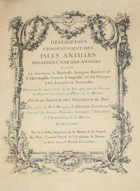
(History of Cartography, Geographic description of the Antilles): Description geographique des isles Antilles possédées par les Anglois
by Bellin, Jacques Nicolas
- Used
- very good
- Hardcover
- first
- Condition
- Used - Very Good
- Edition
- First Edition
- Binding
- Hardcover
- Quantity Available
- 1
- Seller
-
Crozet, Virginia, United States
- Item Price
-
$7,575.00
Show Details
Description:
A Paris: De l'imprimerie de Didot, 1758. This 10.5 inch quarto is in very good condition, sound hinges, 171 pp. with all 22 maps (several folding), plans and views in very good or better condition on heavy paper. Contemporary calf boards with original marbeled pastedowns, two title pages (one decorative with attribution to Bellin), "Tables des Titres" and "Table des Cartes, Plans et Vues." Six compartment, banded spine, with red, gilt title label.Triple (French), gilt fillets on front and rear boards. Bellin was the first chief hydrographic engineer of the French Hydrographic Office (see Tooley's Dictionary of Mapmakers, revised ed.). Ref: Beinecke, Lesser Antilles Collection, 215; Sabin 4553. This is an extremely nice copy.. First Edition. Full-Leather. Very Good.
Item Price
$7,575.00
(City / Town Plan - Toledo, Spain): Toletum
by Braun, Georg and Hogenberg, Franz
- Used
- Condition
- Used
- Binding
- Unknown
- Quantity Available
- 1
- Seller
-
Crozet, Virginia, United States
- Item Price
-
$1,800.00
Show Details
Description:
Braun & Hogenberg, 1598. Near fine, early color, latin edition (applicable text verso). Very decorative town plan of Toledo, Spain from this edition of the famous city atlas. Cherubim, palace, temple all present as separate images. These plans are well-known to collectors, and this particular item is increasingly uncommon. The full atlas was published in 6 volumes, in various editions, from 1572-1617. It was a collaborative work between many artists, engravers and cartographers (for a nice discussion of the history of this atlas, see Goss's THE MAPMAKERS ART, pp. 260-5). The map image measures 12.75x20 inches..
Item Price
$1,800.00
(Map of Caspian Sea & Environs): Nova et Accuratissima Maris Caspii...petri Alexii Filii. Magni Russorum Emper
by Seutter, GM
- Used
- Condition
- Used
- Binding
- Unknown
- Quantity Available
- 1
- Seller
-
Crozet, Virginia, United States
- Item Price
-
$550.00
Show Details
Description:
Augsburg: Seutter, 1740. VG+, copperplate engraving with original hand coloring (color similar to Homann, with whom Seutter apprenticed before going out on his own in about 1707). There is minimal right marginal soling, but the image and color are exceptionally bright. Decorative cartouche, as usual, probably an allegorical representation of imperial Russia. The map measures 19.25x22.5 inches. .
Item Price
$550.00
(Map of Pennsylvania): Geographical, Statistical, and Historical Map of Pennsylvania
by Carey & Lea (engr.by Young & Delleker)
- Used
- Hardcover
- first
- Condition
- Used
- Binding
- Hardcover
- Quantity Available
- 1
- Seller
-
Crozet, Virginia, United States
- Item Price
-
$400.00
Show Details
Description:
Philadelphia (Chestnut Street), 1822: HC Carey and I Lea, 1822. VG due to some minimal dampstaining most evident left upper corner, and minimally crossing neatline. The color portion of the map shows no significant visual effects from the stains. The original hand-colored image is clear and bright, with the surrounding letterpre ss text detailing aspects of population, climate, commerce, religion, government. There is a nice general historical sketch (in a separate page of original text, included here-- "Appendix to No. 18") in the letterpress. From the first edition "A Complete Historical, Chronological, and Geographical American Atlas...", which was also the first American atlas with letterpress printing on the map. This is a nice map, but for the defects described. The map image is 45x31cm; the entire image is 52.5x42cm..
Item Price
$400.00
(Map of Eastern America and Atlantic Ocean): Carte De L'Ocean Occidental et Partie De L'Amerique Septentrionale..Charlevoix..fait En 1720
by Bellin, Jacques Nicolas
- Used
- Condition
- Used
- Binding
- Unknown
- Quantity Available
- 1
- Seller
-
Crozet, Virginia, United States
- Item Price
-
$485.00
Show Details
Description:
Paris: Ganeau, 1744. Excellent condition, strong impression, b&w engraved copperplate from Tome III of the 4to, 1744 edition of Charlevoix's "Histoire de la Nouvelle France" (Journal D'un Voyage...). The image is 9.5 x 14.5 inches, with folds as issued. This image has the full eastern USA, including Louisiane, north to Newfoundland, most of the Great Lakes, teh Atlantic Ocean, Acores, and east to the western coasts of Africa, Spain, France and British Isles. It is quite attractive, and not often seen for sale in this early state..
Item Price
$485.00

(Map of Java/Borneo/Sumatra): Insulae Iavae Cum parte insularum Borneo Svmatrae et circumjacentium insularum novissima delineatio
by Jansson (Joannes Janssonius)
- Used
- Paperback
- Condition
- Used
- Binding
- Paperback
- Quantity Available
- 1
- Seller
-
Crozet, Virginia, United States
- Item Price
-
$875.00
Show Details
Description:
Jansson, c. 1657. Near-fine nicely colored (later) map with striking cartouche. Minor marginal soiling, no tears, 2 scales (Milliaria Germanica Communia and Milliaria Gallica Communia). Jansson was the son-in-law of Jodocus Hondius, and eventually managed their firm. Jansson eventually published an 11 volume Atlas Major (many of his maps were similar to, and prpbably copied from Blaeu's-- see Moreland & Bannister's ANTIQUE MAPS, 1989 edition). A beautiful map, 41.5x50.5cm..
Item Price
$875.00

(Map of Southern Itlay): Royaume De Naples et De Sicile Par le S. Robert De Vaugondy
by Robert de Vaugondy
- Used
- Condition
- Used
- Quantity Available
- 1
- Seller
-
Crozet, Virginia, United States
- Item Price
-
$75.00
Show Details
Description:
Paris: Chez le Sr. Fortin , 1778. VG- (some staining right margin not crossing neatline), minimal edge browning and foxing. Folds as issued. Plate 29 from atlas. Nicely hand colored outlines, heavy paper, specifically of Spain and Portugal, with the Balaeric Islands and the Strait of Gibraltar. This is from a 1778 edition (later issue) of the family's "Nouvel Atlas Portatif" (see Pedley's "Bel et Utile" re: historical details for this prominent mapmaking family). The image measures 9.5x11 inches..
Item Price
$75.00
(Map of Bavaria, Austria): Cercles de Baviere et D'Autriche Par le S. Robert De Vaugondy
by Robert de Vaugondy
- Used
- Condition
- Used
- Quantity Available
- 1
- Seller
-
Crozet, Virginia, United States
- Item Price
-
$110.00
Show Details
Description:
Paris: Chez le Sr. Fortin , 1778. VG, minimal edge browning and foxing, trace upper margin dampstain. Folds as issued. Plate 25 from atlas. Nicely hand colored outlines, heavy paper, specifically of Baviaria and Austrian empire. This is from a 1778 edition (later issue) of the family's "Nouvel Atlas Portatif" (see Pedley's "Bel et Utile" re: historical details for this prominent mapmaking family). The image measures 9.5x11 inches..
Item Price
$110.00
(Map of Itlay): L'Italie Par le S. Robert De Vaugondy
by Robert de Vaugondy
- Used
- Condition
- Used
- Quantity Available
- 1
- Seller
-
Crozet, Virginia, United States
- Item Price
-
$125.00
Show Details
Description:
Paris: Chez le Sr. Fortin , 1778. VG, minimal edge browning and foxing. Folds as issued. Plate 31 from atlas. Nicely hand colored outlines, heavy paper, specifically of the entirety of Italy, with the Gulf of Venice, Corsica, Sardinia, Sicily. This is from a 1778 edition (later issue) of the family's "Nouvel Atlas Portatif" (see Pedley's "Bel et Utile" re: historical details for this prominent mapmaking family). The image measures 9.5x11 inches..
Item Price
$125.00
(Map of Northern Itlay): La Lombardie, Le Duche De Toscane, L'Etat Du St. Siege, et Lisle De Corse. Par le S. Robert De Vaugondy
by Robert de Vaugondy
- Used
- Condition
- Used
- Quantity Available
- 1
- Seller
-
Crozet, Virginia, United States
- Item Price
-
$150.00
Show Details
Description:
Paris: Chez le Sr. Fortin , 1778. VG, minimal edge browning and foxing. Folds as issued. Plate 31 from atlas. Nicely hand colored outlines, heavy paper, specifically of northern Italy with Corsica. This is from a 1778 edition (later issue) of the family's "Nouvel Atlas Portatif" (see Pedley's "Bel et Utile" re: historical details for this prominent mapmaking family). The image measures 9.5x11.5 inches..
Item Price
$150.00
(Map of Norway, Denmark): 1. Norwege 2. Royaume De Danemarck Par le S. Rober De Vaugondy
by Robert de Vaugondy
- Used
- Condition
- Used
- Quantity Available
- 1
- Seller
-
Crozet, Virginia, United States
- Item Price
-
$150.00
Show Details
Description:
Paris: Chez le Sr. Fortin , 1778. VG+, minimal edge browning and foxing. Folds as issued. Plate 11 from atlas. Nicely hand colored outlines, heavy paper, specifically of Norway and Denmark (2 plates, 1 sheet). This is from a 1778 edition (later issue) of the family's "Nouvel Atlas Portatif" (see Pedley's "Bel et Utile" re: historical details for this prominent mapmaking family). The image measures 9.5x8.5 inches..
Item Price
$150.00
(Map of Europe, British Isles, Scandinavia): L'Europe Par le S. Robert De Vaugondy
by Robert de Vaugondy
- Used
- Condition
- Used
- Quantity Available
- 1
- Seller
-
Crozet, Virginia, United States
- Item Price
-
$150.00
Show Details
Description:
Paris: Chez le Sr. Fortin , 1778. VG+, minimal edge browning and foxing. Folds as issued. Plate 5 from atlas. Nicely hand colored outlines, heavy paper, including continental Europe, British Isles, Scandinavia, Iceland. This is from a 1778 edition (later issue) of the family's "Nouvel Atlas Portatif" (see Pedley's "Bel et Utile" re: historical details for this prominent mapmaking family). The image measures 9.5x11 inches..
Item Price
$150.00
(Map of North Africa): Barbarie, Egypte, Nigritie, Guinee, Nubie, Abissinie. Par le S. Robert De Vaugondy
by Robert de Vaugondy
- Used
- Condition
- Used
- Quantity Available
- 1
- Seller
-
Crozet, Virginia, United States
- Item Price
-
$150.00
Show Details
Description:
Paris: Chez le Sr. Fortin , 1778. VG, minimal edge browning and foxing. Folds as issued. Plate 40 from atlas. Nicely hand colored outlines, heavy paper, specifically of northern Africa, with Egypt and Abyssinia, including the Cape Verde Islands. This is from a 1778 edition (later issue) of the family's "Nouvel Atlas Portatif" (see Pedley's "Bel et Utile" re: historical details for this prominent mapmaking family). The image measures 9.5x14 inches..
Item Price
$150.00
(Map of Southern Itlay): Royaume De Naples et De Sicile Par le S. Robert De Vaugondy
by Robert de Vaugondy
- Used
- Condition
- Used
- Quantity Available
- 1
- Seller
-
Crozet, Virginia, United States
- Item Price
-
$150.00
Show Details
Description:
Paris: Chez le Sr. Fortin , 1778. VG, minimal edge browning and foxing. Folds as issued. Plate 32 from atlas. Nicely hand colored outlines, heavy paper, specifically of southern Italy with Sicily as an inset. This is from a 1778 edition (later issue) of the family's "Nouvel Atlas Portatif" (see Pedley's "Bel et Utile" re: historical details for this prominent mapmaking family). The image measures 9.5x11.5 inches..
Item Price
$150.00
(2 Map Set of Russia- North & South): 1. Partie Septentrionale De La Russie Europeenne... 2. Partie Meridionale De La Russie Europeenne, Tartarie Russienne, Petite Tartarie. Par le S. Robert De Vaugondy
by Robert de Vaugondy
- Used
- Condition
- Used
- Quantity Available
- 1
- Seller
-
Crozet, Virginia, United States
- Item Price
-
$185.00
Show Details
Description:
Paris: Chez le Sr. Fortin , 1778. VG+, minimal edge browning and foxing. Folds as issued. Plates 12 & 13 from atlas. Nicely hand colored outlines, heavy paper, specifically of white Russia. This is from a 1778 edition (later issue) of the family's "Nouvel Atlas Portatif" (see Pedley's "Bel et Utile" re: historical details for this prominent mapmaking family). Each image measures 9.5x11.5 inches..
Item Price
$185.00
(Map of Britian, Ireland, Scotland): Les Isles Britanniques Par Le S. Rober De Vaugondy
by Robert de Vaugondy
- Used
- Condition
- Used
- Quantity Available
- 1
- Seller
-
Crozet, Virginia, United States
- Item Price
-
$185.00
Show Details
Description:
Paris: Chez le Sr. Fortin , 1778. VG+, minimal edge browning and foxing. Folds as issued. Plate 6 from atlas. Nicely hand colored outlines, heavy paper, including a general view of the UK, with Britain, Scotland and Ireland. This is from a 1778 edition (later issue) of the family's "Nouvel Atlas Portatif" (see Pedley's "Bel et Utile" re: historical details for this prominent mapmaking family). The image measures 9.5x11 inches..
Item Price
$185.00

More Photos
The Sky and the Forest
by Forester, C.S
- Used
- very good
- Hardcover
- first
- Condition
- Used - Very Good
- Jacket Condition
- Very Good
- Edition
- First Edition
- Binding
- Hardcover
- Quantity Available
- 1
- Seller
-
Salem, Oregon, United States
- Item Price
-
$34.89$20.93Save $13.96!
Show Details
Description:
C.S. Forester: The Sky and the Forest. Little, Brown and Company, Boston. Stated First Edition First Printing Thus August, 1948. Cover price $2.75. Used. VG BOOK/VG UNCLIPPED DUST JACKET. A story of a central Africa. By C.S. Forester, author of the Admiral Hornblower series.
Item Price
$34.89$20.93
Save $13.96
!
![Alaska and Klondike Region; [With inset of Klondike Region on the Upper Yukon detail] [From an...](https://d3525k1ryd2155.cloudfront.net/h/062/537/1339537062.0.m.jpg)
Alaska and Klondike Region; [With inset of Klondike Region on the Upper Yukon detail] [From an atlas, "Gazetteer of Alaska and Yukon Region " pp. 105 and 106]
by Miller, J. Martin
- Used
- very good
- Condition
- Used - Very Good
- Edition
- Unknown
- Quantity Available
- 1
- Seller
-
Sebastopol, California, United States
- Item Price
-
$39.00
Show Details
Description:
Chicago: J. Martin Miller, 1899. Unknown. Map. Very Good. [Map copyright 1899, printing date of Atlas later] [19.875x15.125in]; Colored map of Alaska with steamer routes from Portland and Seattle, insets of the Klondike Region on the Upper Yukon and Western portion of Aleutian Islands; On verso index of places and names with two large black and white images; Age toning to all edges, water stain marks on bottom, slight printing offset of colors, small chips and closed tears to lower edge;.
Item Price
$39.00

Zemepis Sveta - Monsunova Asie
by De La Blache, P. Vidal; Gallois, L
- Used
- Hardcover
- Condition
- Used - Very Good Condition
- Jacket Condition
- No Dust Jacket
- Binding
- Hardcover
- Quantity Available
- 1
- Seller
-
Oak Point, Texas, United States
- Item Price
-
$60.00
Show Details
Description:
Aventinum, Prague, Czechoslovakia, 1930. Hardcover. Very Good Condition/No Dust Jacket. Text entirely in Czech. Geography book on Asia with numerous photographs and maps. 1931 edition also available. Size: 4mo - over 9 3/4" - 12" tall. 400 pp. Pages are yellowed, but are tight and clean. Moderate shelfwear along the spine. Corners are lightly bumped. Quantity Available: 1. Shipped Weight: 3-5 pounds. Category: Travel & Places; Non-English Language::Czech; Pictures of this item not already displayed here available upon request. Inventory No: 001227. . Additional shipping charges may apply.
Item Price
$60.00

Zemepis Sveta - Monsunova Asie
by De La Blache, P. Vidal; Gallois, L
- Used
- Hardcover
- Condition
- Used - Very Good Condition
- Jacket Condition
- No Dust Jacket
- Binding
- Hardcover
- Quantity Available
- 1
- Seller
-
Oak Point, Texas, United States
- Item Price
-
$60.00
Show Details
Description:
Aventinum, Prague, Czechoslovakia, 1931. Hardcover. Very Good Condition/No Dust Jacket. Text entirely in Czech. Geography book on Asia with numerous photographs and maps. 1930 edition also available. Size: 4mo - over 9 3/4" - 12" tall. 400 pp. Pages are yellowed, but are tight and clean. Moderate shelfwear along the spine. Corners are lightly bumped. Quantity Available: 1. Shipped Weight: 3-5 pounds. Category: Travel & Places; Non-English Language::Czech; Pictures of this item not already displayed here available upon request. Inventory No: 001228. . Additional shipping charges may apply.
Item Price
$60.00

Asia from the Best Authorities, Russell, ca.1800
by Russell
- Used
- Condition
- Used
- Quantity Available
- 1
- Seller
-
Plymouth, Devon, United Kingdom
- Item Price
-
$25.12
Show Details
Description:
Russell, J. : Asia from the Best Authorities. Nd but ca.1800. From "A New Geographical, Historical and Commercial Grammar and Present State of Several Kingdoms of the World". Copper engraving. Size approx 200 x 230mm. Two neat folds. Some age colouring to edges, otherwise clean and bright. Includes Arabia, India, Borneo, Japan, China and eastern Russia.
Item Price
$25.12

North America from the Best Authorities, Russell, ca.1800
by Russell
- Used
- Condition
- Used
- Quantity Available
- 1
- Seller
-
Plymouth, Devon, United Kingdom
- Item Price
-
$25.12
Show Details
Description:
Russell, J. : A General Map of North America from the Best Authorities. Nd but ca.1800. From "A New Geographical, Historical and Commercial Grammar and Present State of Several Kingdoms of the World." Copper engraving. Size approx 200 x 230mm. Two neat folds. Some age colouring to edges, otherwise very clean and bright.
Item Price
$25.12
![MAP OF UTAH [Territory]](https://d3525k1ryd2155.cloudfront.net/h/836/461/1485461836.0.m.jpg)
More Photos
MAP OF UTAH [Territory]
- Used
- Condition
- Used - Very Good-
- Edition
- Original
- Quantity Available
- 1
- Seller
-
Williamsburg, Virginia, United States
- Item Price
-
$65.00
Show Details
Description:
New York, Richmond, Chicago, & Toledo: H. H. Hardesty, 1885. Original color lithographed map printed by Rand, McNally & Company, Engravers and published in HARDESTY'S HISTORICAL AND GEOGRAPHICAL ENCYCLOPEDIA: SPECIAL VIRGINIA EDITION. 19 3/8 inches by 13 1/4 inches on a 21" X 14 1/2" sheet. The map depicts the Territory of Utah in its final form--large areas had been removed and ceded to Nevada, Colorado, Wyoming, and Nebraska since Utah became a U. S. Territory in 1850. The issue of polygamy prevented statehood until it was finally granted in 1896. This map features railroads and topography and uses color to set off counties from each other. Unlike most atlas maps of the period, this map identifies most small towns. The map is guaranteed to be moe than 135 years old. The map is in about very good condition: generally clean and bright, with slight toning of paper and one faint water stain near the center-left edge of the map.. Original. Single Sheet. Very Good-. Elephant…
Read More Item Price
$65.00

Philips Special Map of the Nile, The Advance on Khartum and the Environs of Omdurman. Cc1900
by George Philips and Son,
- Used
- Condition
- Used
- Quantity Available
- 1
- Seller
-
Plymouth, Devon, United Kingdom
- Item Price
-
$32.66
Show Details
Description:
Philips Special map of the Nile illustrating the Advance on Khartum [Khartoum] with an enlargement of the environs of Omdurman [Omdur]. George Philips and Son, London and Liverpool Ca 1900. 580mm x 900mm folded map. Front title wrapper has come loose, not affecting map area. Three maps are displayed within the sheet. Map1. Map of the Nile Valley 520mm x 300mm showing the approaches of Khartum. Scale 1inch to 100 Geographical miles. Coloured indicating Possessions and Protectorates of European Powers. Map 2. Special map of the Nile from Dongola to Khartum. Scale 16 miles to the inch. Coloured. In set in this map is Map3. Environs of Omdurman, Scale 5 statute miles to the inch. Some small breaks at some folds, not affecting imagery or use of map. Title label is damaged, the map is clean and bright, probably unused. A very interesting record.
Item Price
$32.66

Last Tales
by Dinesen, Isak
- Used
- very good
- Hardcover
- first
- Condition
- Used - Very Good
- Jacket Condition
- Good+
- Edition
- First Edition
- Binding
- Hardcover
- Quantity Available
- 1
- Seller
-
Salem, Oregon, United States
- Item Price
-
$120.00$72.00Save $48.00!
Show Details
Description:
Dinesen, Isak: Last Tales, A Collection of Twelve New Tales of Compelling Beauty 1957, Random House. First Edition. Stated First Printing Thus. Used. Very Good/Good+ original red dust jacket, price-clipped. Jacket states 11/57 on front flap. 5 3/4 X
Item Price
$120.00$72.00
Save $48.00
!

The Adventure of Wrangel Island
by Vilhjalmur Stefansson
- Used
- good
- Hardcover
- first
- Condition
- Used - Good
- Jacket Condition
- No DJ Included
- Edition
- First Edition
- Binding
- Hardcover
- Quantity Available
- 1
- Seller
-
Salem, Oregon, United States
- Item Price
-
$124.89$74.93Save $49.96!
Show Details
Description:
The Adventure of Wrangel Island, Alaska (1925 Macmillan 1st Edition) HISTORY OF ALASKA. EXLIB. Good Condition/ No DJ included. Fold-out map affixed to binding at the back of the book has never been opened. The story of the (unsuccessful) attempted colonization of Wrangel Island Alaska. 413 pages plus appendix, Index. Titling is still bright. A clean, solid copy. Scarce.
Item Price
$124.89$74.93
Save $49.96
!