Description:
San Francisco: Lithographed by W. W. Elliott Lithograph. No date (c.1890). 24x38 inches. Lithographed in black on white. Top border edge just a bit rough, but a fine crisp copy. A magnificent bird's-eye view showing all of the city of Stockton, California and the surrounding country. All of the streets and roads are labeled. Surrounding the view are 26 insets showing public and commercial buildings. Includes promotional text for the city as well as an index of significant buildings and places, keyed by number to the view. At the bottom border, "Compliments of E.A. Crennan & Co., Real Estate Auctioneers, Stockton, California." W.W. Elliott is best known for his views in a number of the county histories produced in the 1870's and 1880's. Unlike many lithographers of similar views of that period, Elliott had a knack for artistic shading which gave his images a wonderful quality of depth and clarity. This lithograph is quite scarce and is rarely offered It is not mentioned in…
Read More SERVICE DES VAISSEAUX DE L'EMPEREUR ~ PILOTE DES ILES BRITANNIQUES by Jacques Nicolas Bellin, Jean-Rene de Verdun de la Crenne, Denis [Amiral] Decres, Charles-Francois Beautemps-Beaupre & after John Knight, Hamilton Moore, Murdo Downie, Joseph Huddart, Stuart Amos Arnold and others - 1757-1804
by Jacques Nicolas Bellin, Jean-Rene de Verdun de la Crenne, Denis [Amiral] Decres, Charles-Francois Beautemps-Beaupre & after John Knight, Hamilton Moore, Murdo Downie, Joseph Huddart, Stuart Amos Arnold and others
![SERVICE DES VAISSEAUX DE L'EMPEREUR ~ PILOTE DES ILES BRITANNIQUES by Jacques Nicolas Bellin, Jean-Rene de Verdun de la Crenne, Denis [Amiral] Decres, Charles-Francois Beautemps-Beaupre & after John Knight, Hamilton Moore, Murdo Downie, Joseph Huddart, Stuart Amos Arnold and others - 1757-1804](https://d3525k1ryd2155.cloudfront.net/h/439/872/932872439.0.m.jpg)
SERVICE DES VAISSEAUX DE L'EMPEREUR ~ PILOTE DES ILES BRITANNIQUES
by Jacques Nicolas Bellin, Jean-Rene de Verdun de la Crenne, Denis [Amiral] Decres, Charles-Francois Beautemps-Beaupre & after John Knight, Hamilton Moore, Murdo Downie, Joseph Huddart, Stuart Amos Arnold and others
- Used
- very good
- Hardcover
Paris: Depot General de la Marine, 1757-1804. Hardcover. Very Good. 20 1/2 in. X 25 1/2 in High. Full calf binding with 7 raised bands with gilt decoration on spine, gilt border on covers. Label on spine 'Les Iles Britanniques' now missing, gilt embossed title on front cover reads 'Service des Vaisseaux de L'Empereur'. Bound in are 30 copper engraved maps & one original ink drawing dating from 1757-1804. Probably bound in 1804 or 1805 in preparation of Napoleon's planned invasion of England, which was called off after other military set-backs. Many are French copies of British maps by John Knight etc. On the front paste-down a calling card of Mr. David B. Ogden 12 East. Tenth Street, is pasted in, with 'To be returned to & New York' added in ink. Above the card is written in ink 'Ex libris Richard Evans Esq.' David B. Ogden (1847-1923) was a lawyer who was president of the NY Bar Assoc. & collected a large library including Military History. Richard Evans was his father-in-law, who was from Philadelphia. Condition of the book is VERY GOOD; Covers & spine considerably scuffed and soiled, gilt lettering dull on cover, spine label missing, front & rear hinges cracking at gutter, a few of the maps have become detached from the stubs they were mounted on, others are partially detached. The condition of the maps themselves is very good, with very little soiling or staining and no foxing (any exceptions are noted in individual map listing). None of the maps are colored except the hand drawn one. Most are published by the Depot General de la Marine, Paris. More photos available on request.
The maps, in order of binding-
1) 'L'Ocean Atlantique ou Occidental' by Bellin 1786, revue et corrigee 1792 6th edition. 25 x 35 in. map with two 6 in. fold-out flaps of latitude & longitude, making the over-all size 25 x 46 in.
2) 'Carte Reduite des Mers du Nord' by Verdun de la Crenne, 1776 25 x 38.
3) 'Partie de la mer du nord' Tiree de la Carte Anglais Publiee par Cap. John Knight en 1803. This is an original ink drawing, with watercolor. 34 1/2 x 38 in.
4) 'Carte Reduite des Costes de Flandres et de Hollande' by Bellin, 1763 25 x 38 in.
5) 'Dunkerque' By Beautemps-Beaupre, an XI (1803) vertical format, 25 x 38 in. (fits together with map 6)
6) 'Reconnaisance Hydrographique de la Cote Nord de la France, Rade de Dunkerque et ses environs' an XI (1803) vertical format, 25 x 38
7) 'Carte Reduite de la Manche' an VII (1799) Nouvelle Edition de L'an XI (1803) 25 x 38 in.
8) 'Carte Reduite des Iles Britanniques, Premiere Feuille' by Bellin, 1757 25 x 38 in.
9) Ibid, Seconde Feuille 1757
10) Ibid, Triosieme Feuille, 1757
11) Ibid, Quatrieme Feuille 1757
12) 'Plan au Port de Plymouth' Vice- Amiral Decres, an XII (1804) 18 1/2 x 23 Vertical format
13) 'Plan de Tor-Bay, Babacon-Bay et de l'Entree de Dartmouth' Leve en 1790 par le Cap. J. Knight, Publie par Contre-Amiral Decres l'an XII (1804), 25 x 38 in. Vertical format.
14) 'Carte de L'Isle de Wight et de la Cote Adjacents de Hampshire' apres Wm. Prince 1800 (Laurie & Whittle) Contre-Amiral Decres an XII (1804) 25 x 38 in.
15) 'Carte du Passage des Needles & Carte des Environs de Portsmouth' Apres John Knight 1797 , Vice Amiral Decres l'an XII (1804) 25 x 38 in. Vertical format
16) 'Carte de la Rade des Dunes' Vice-Amiral Decres An XII (1804), 18 1/2 x 25 in. Vertical format
17) 'Cote Orientale D'Angleterre depuis South Portland, jusqu'a Lowestoft' Apres Hamilton Moore 1789, Depot de la Marine An VI (1798) 25 x 38 in.
18) 'Cote Orientale D'Angleterre, depuis Loewstoft jusques et compris L'Embrouchure de L'Humber' Apres Hamilton Moore 1789, Depot de la Marine An VI (1798) 25 x 38 in.
19) 'Cote Particuliere de la Cote Orientale D'Angleterre depuis le Cap Gibralter jusqu'au Golfe d'Edinburg' Apres Hamilton Moore 1789, Depot de la Marine An XII (1804) 25 x 38 in.
20) 'Cote Particuliere d'Ecosse depuis St. Abb's Head - Duncansby Head' apres Murdo Downie, Vice-Amiral Decres An XII (1804) 25 x 38 in.
21) 'Carte des Iles Orcades et de la cote nord d'Ecosse, depuis le Cap Wrath, jusqu'au Cap Duncansby' Apres Mackenzie, Vice-Amiral Decres, An XII (1804) 25 x 38 in.
22) 'Carte Particuliere de la Cote Occidentale de L'Ecosse, depuis le Cap Wrath jusqu'a la Pointe d'Ardnamurchan' apres Cartes Anglais, Contre-Amiral Decres, An XII (1814) 25 x 38 in.
23) 'Carte Particuliere de la Cote Occidentale d'Ecosse, depuis la Pointe Ardnamurchan jusqu'au Mull de Galloway' apres Cartes Anglais, Contre-Amiral Decres, an XII (1804) 25 x 38 in.
24) 'Carte Reduite de l'Entre de la Mer d'Irlande et du Canal de Bristol' dressee pour le Service des Vaisseaux Francais, Grave par Houdan, an VI (1798) 25 x 38 in.
25) 'Carte Particuliere du Canal de Bristol au Embouchure de la Severne' pour le Service des Vaisseaux Francais, grave par E. Collin, an VI 91798) 25 x 38 in.
26) 'Carte d'Irlande, Divisee en Provinces et Comtes' uncredited, no date, 25 x 38 in. vertical format
27) 'Carte des Cotes Occidentales d'Irland' apres Stuart Amos Arnold & M. Mackenzie, Contre-Amiral Decres, an XII (1804) 25 x 38 in. vertical format
28) 'Carte Particuliere de la Cote Sud-Ouest d'Irlande depuis les Iles Saltees jusqu'a l'Embrouchure du Shannon' This title includes this map and the following map-- this map covers Les Iles Saltees to Clonekilty Bay. Apres Capt. Joseph Huddart, Contre-Amiral Decres, an XII (1804) 25 x 38 in. vertical format
29) Untitled Chart--This map is a continuation of the previous map to the west--Clonekilty bay to the Mouth of the Shannon. 1804 Decres 25 x 38 in. vertical format
30) 'Carte Particuliere de la Cote Ouest d'Irlande depuis Sligo jusqu'a l'Embrouchure du Shannon' apres Capt. Joseph Huddart, Contre-Amiral Decres An XII (1804) 25 x 38 in. vertical format.
-
Bookseller
Andre Strong Bookseller
 (US)
(US)
- Format/Binding Hardcover
- Book Condition Used - Very Good
- Quantity Available 1
- Binding Hardcover
- Publisher Depot General de la Marine
- Place of Publication Paris
- Date Published 1757-1804
![Stockton Looking East. San Joaquin County, Cal. Original Bird's Eye View. [LITHOGRAPH]](https://d3525k1ryd2155.cloudfront.net/h/929/544/257544929.0.m.jpg)
Stockton Looking East. San Joaquin County, Cal. Original Bird's Eye View. [LITHOGRAPH]
- Used
- Condition
- Used
- Binding
- Unknown
- Quantity Available
- 1
- Seller
-
San Francisco, California, United States
- Item Price
-
$3,250.00
Show Details
Item Price
$3,250.00

(Celestial chart, lunar orbits and eclipses): Theoria Lunae, Eius Motum Per Eccentricum Et Epicyclum Demonstrans
by Valk, Gerard and Schenk, Petrus [Cellarius, Andreas]
- Used
- Condition
- Used
- Binding
- Unknown
- Quantity Available
- 1
- Seller
-
Crozet, Virginia, United States
- Item Price
-
$2,675.00
Show Details
Description:
Amsterdam: Schenk and Valk, 1708. Very good, minimal foxing, early color (with more recent enhancement) copperplate from this 1708 (original version published in 1660 by Jansson) Schenk/Valk issue of (Andreas Cellarius') "Harmonia Macrocosmica Seu Atlas Universalis Et Novus." The striking image measures 43 x 52 cm on a sheet 51 x 60 cm. Numerous cherubim surrond the circular view, as does an outer circle of a number of signs of the zodiac. There are a couple of pinhole defects, repaired verso, with no significant loss of imate. Ref: Koeman, Atlantes Neerlandici, Cel.3..
Item Price
$2,675.00

(Old World hemispheric map with climatic zones): Hemisphaerium Orbis Antiqui, Cumzonis, Circulis, Et Situ Populorum Diverso
by Valk, Gerard and Schenk, Petrus [Cellarius, Andreas]
- Used
- Condition
- Used
- Binding
- Unknown
- Quantity Available
- 1
- Seller
-
Crozet, Virginia, United States
- Item Price
-
$2,675.00
Show Details
Description:
Amsterdam: Schenk and Valk, 1708. Very good, minimal foxing, early color copperplate from this 1708 (original version published in 1660 by Jansson) Schenk/Valk issue of (Andreas Cellarius') "Harmonia Macrocosmica Seu Atlas Universalis Et Novus." The striking image measures 41 x 51 cm on a sheet 50 x 59 cm. Numerous cherubim surrond the eastern hemispheric view, which is also divided into frigid, termperate, tropical and torrid zones. There are separate armillary and habitat zonal spheres in the lower corners. Ref: Koeman, Atlantes Neerlandici, Cel.3. There are bilateral, faint water-stains in the pink circular band surrounding the map image..
Item Price
$2,675.00
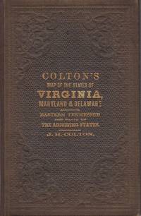
Colton's New Topographical Map of the States of Virginia, Maryland and Delaware, showing also eastern Tennessee, and parts of other adjoining states; all the Fortifications, Military Stations, Rail Roads, Common Roads and other internal improvements.; [Cover reads: Colton's Map of the States of Virginia, Maryland and Delaware...]
by Colton, J.H.
- Used
- very good
- Hardcover
- Condition
- Used - Very Good
- Binding
- Hardcover
- Quantity Available
- 1
- Seller
-
Charlottesville, Virginia, United States
- Item Price
-
$3,000.00
Show Details
Description:
New York: J.H. Colton, 1864. Brown pebbled cloth cover stamped in blind and gilt is in pristine condition. 82 x 110 cm unfolded; 10 x 16 cm folded. Full original hand coloring on onion-skin paper. Very Good. Professionally repaired tear around section attaching to the board, and extending beneath the cartouche (hardly noticeable from the front), minor spotting beneath the cartouche. Note that this is not backed with linen as some folding maps are; the paper is nearly onion skin and while not brittle is fragile. We do not recommend that it be flattened for framing. A highly important folding pocket map to be used in the field during the Civil War, in extraordinary condition. LC Civil War Maps 48.2. OCLC lists only five locations for the 1864 edition: LC, Yale, Penn State, Library of Virginia and Wake Forest. Americana Exchange records only one auction record in the last 15 years, and only two before that.
Item Price
$3,000.00

More Photos
CORRESPONDANCE DU GLOBE TERRESTRE A LA SPHERE CELESTE. SITUATION DES HABITANS DU MONDE, DES CERCLES DE LONGITUDE ET DE LATITUDE, ET DES DIVERSES POSITIONS DE LA SPHERE [ATLAS]
by de Fer, N.
- Used
- very good
- Hardcover
- first
- Condition
- Used - Very Good
- Jacket Condition
- No Jacket
- Edition
- First Edition
- Binding
- Hardcover
- Quantity Available
- 1
- Seller
-
Ottawa, Ontario, Canada
- Item Price
-
$3,200.00
Show Details
Description:
Paris: Published by the author, 1705. Map. Very Good. Hardcover. First Edition. Wide 8vo. An atlas comprising 19 maps (1. Des cercels de Longitude et de Latitude, et des Diverses Positions de la Sphere; 2. Carte General du Globe Terrestre et Aquatiques ou Mappemonde en deux Plans-hemisphere 1705; 3. l'Europe Dresee sur diverse Relations; 4. L'Asie Dressee Sur Divers Relations 1705; 5. L'Aftique Dressez sur les dernieres Relations; 6. L'Amerique Meridionale; 7. L'Amerique Septentrionale et les Terres Polaires Arctique; 8. La France Avec Ses Acquisitions Insqu'a l'Annee 1705; 9. Les Environs de Paris 1705); 10. Les XVII Provinces des Pais Bas Divisees 1705; 11. Les Isles Britanniques ou Sont les Royaumes D'Angleterre D'Ecosse, et D'Irleland avec les Costes Septentrionales de France et Celles de Pais Bas; 12. Suede Norvegue et Dannemarck 1705; 13. Les Estats de la Couronne de Pologne 1705; 14. L'Allemagne Divisee En Dix Cercles Dressee sur les Derniers…
Read More Item Price
$3,200.00
Stockton Looking East. San Joaquin County, Cal. Original Bird's Eye View. [LITHOGRAPH]
- Used
- Condition
- Used
- Binding
- Unknown
- Quantity Available
- 1
- Seller
-
San Francisco, California, United States
- Item Price
-
$3,250.00
Show Details
Description:
San Francisco: Lithographed by W. W. Elliott Lithograph. No date (c.1890). 24x38 inches. Lithographed in black on white. Top border edge just a bit rough, but a fine crisp copy. A magnificent bird's-eye view showing all of the city of Stockton, California and the surrounding country. All of the streets and roads are labeled. Surrounding the view are 26 insets showing public and commercial buildings. Includes promotional text for the city as well as an index of significant buildings and places, keyed by number to the view. At the bottom border, "Compliments of E.A. Crennan & Co., Real Estate Auctioneers, Stockton, California." W.W. Elliott is best known for his views in a number of the county histories produced in the 1870's and 1880's. Unlike many lithographers of similar views of that period, Elliott had a knack for artistic shading which gave his images a wonderful quality of depth and clarity. This lithograph is quite scarce and is rarely offered It is not mentioned in…
Read More Item Price
$3,250.00
(Old World hemispheric map with climatic zones): Hemisphaerium Orbis Antiqui, Cumzonis, Circulis, Et Situ Populorum Diverso
by Valk, Gerard and Schenk, Petrus [Cellarius, Andreas]
- Used
- Condition
- Used
- Binding
- Unknown
- Quantity Available
- 1
- Seller
-
Crozet, Virginia, United States
- Item Price
-
$2,675.00
Show Details
Description:
Amsterdam: Schenk and Valk, 1708. Very good, minimal foxing, early color copperplate from this 1708 (original version published in 1660 by Jansson) Schenk/Valk issue of (Andreas Cellarius') "Harmonia Macrocosmica Seu Atlas Universalis Et Novus." The striking image measures 41 x 51 cm on a sheet 50 x 59 cm. Numerous cherubim surrond the eastern hemispheric view, which is also divided into frigid, termperate, tropical and torrid zones. There are separate armillary and habitat zonal spheres in the lower corners. Ref: Koeman, Atlantes Neerlandici, Cel.3. There are bilateral, faint water-stains in the pink circular band surrounding the map image..
Item Price
$2,675.00

More Photos
A Modern, Authentic and Complete System of Universal Geography
by Rev. Thomas Bankes
- Used
- very good
- Hardcover
- Condition
- Used - Very Good
- Binding
- Hardcover
- Quantity Available
- 1
- Seller
-
Farningham, Kent, United Kingdom
- Item Price
-
$4,333.54
Show Details
Description:
London: C.Cooke, 1793 Undated circa 1793. The content based on information received up until 1793. 6+990pp+2 - 88 plates, 22 maps. Whilst the scope purports to be the genuine history and description of the Whole World, such was the importance of Cook's discoveries that the first 106pp incorporating 25 plates and three maps is taken up with Cook's voyages. To this is included a particular description of the improved state of the New Colony formed at Port Jackson and Norfolk Island, where the convicts are now settled, and an account of the excursions and discoveries made in the interior parts of New Holland. Altogether this is a gargantuan production with stunning plates and maps. Contemporary full calf, superbly rebacked with the original spine relaid. Photographs available on request.
Item Price
$4,333.54
More Photos
CORRESPONDANCE DU GLOBE TERRESTRE A LA SPHERE CELESTE. SITUATION DES HABITANS DU MONDE, DES CERCLES DE LONGITUDE ET DE LATITUDE, ET DES DIVERSES POSITIONS DE LA SPHERE [ATLAS]
by de Fer, N.
- Used
- very good
- Hardcover
- first
- Condition
- Used - Very Good
- Jacket Condition
- No Jacket
- Edition
- First Edition
- Binding
- Hardcover
- Quantity Available
- 1
- Seller
-
Ottawa, Ontario, Canada
- Item Price
-
$3,200.00
Show Details
Description:
Paris: Published by the author, 1705. Map. Very Good. Hardcover. First Edition. Wide 8vo. An atlas comprising 19 maps (1. Des cercels de Longitude et de Latitude, et des Diverses Positions de la Sphere; 2. Carte General du Globe Terrestre et Aquatiques ou Mappemonde en deux Plans-hemisphere 1705; 3. l'Europe Dresee sur diverse Relations; 4. L'Asie Dressee Sur Divers Relations 1705; 5. L'Aftique Dressez sur les dernieres Relations; 6. L'Amerique Meridionale; 7. L'Amerique Septentrionale et les Terres Polaires Arctique; 8. La France Avec Ses Acquisitions Insqu'a l'Annee 1705; 9. Les Environs de Paris 1705); 10. Les XVII Provinces des Pais Bas Divisees 1705; 11. Les Isles Britanniques ou Sont les Royaumes D'Angleterre D'Ecosse, et D'Irleland avec les Costes Septentrionales de France et Celles de Pais Bas; 12. Suede Norvegue et Dannemarck 1705; 13. Les Estats de la Couronne de Pologne 1705; 14. L'Allemagne Divisee En Dix Cercles Dressee sur les Derniers…
Read More Item Price
$3,200.00
![Theatro del mundo y de el tiempo compuesto por Ioan Paulo Gallucio Salo[n]ese; traducido de...](https://d3525k1ryd2155.cloudfront.net/h/806/735/1343735806.0.m.jpg)
More Photos
Theatro del mundo y de el tiempo compuesto por Ioan Paulo Gallucio Salo[n]ese; traducido de lengua latina en castellana y anadido por Miguel Perez: (Theatro del mundo y de el tiempo compuesto por Ioan Paulo Gallucio Salo[n]ese; traducido de lengua latina en castellana y añadido por Miguel Perez)
by Giovanni Paolo Gallucci
- Used
- fair
- Condition
- Used - Fair
- Quantity Available
- 1
- Seller
-
Fort Lauderdale, Florida, United States
- Item Price
-
$4,250.00
Show Details
Description:
Three raised bands to spine; remnants of label to spine. Gallucci's atlas is the first to make use of Copernicus' catalogue of coordinates, and presents the 48 maps of the Ptolemaic constellations with striking and original constellation figures. Christies. This copy has an additional leaf with four part astronomical dial (for latitude 39) before leaf 100. Also an additional leaf with four part astronomical dial (for latitude 41) before leaf 101, and a two part dial before 102 (for latitude 48); lacking part of leaf 115 dial. Pen and ink caricature of soldiers to verso of leaf 328. Lacking front fly and initial 6 leaves, leaf 8; rear fly and leaves 356-376 (comprising final tables and Index). Leaf 38 three wheels (Getty 2), 54 (Getty lacking dial); leaf 97 (missing in Getty) present with all dials. Leaf 100 dial has the arm missing from the Getty copyhas dial missing from Getty leaf 129. ; 354 pages; All shipments through USPS insured Priority Mail.
Item Price
$4,250.00

More Photos
The Sky and the Forest
by Forester, C.S
- Used
- very good
- Hardcover
- first
- Condition
- Used - Very Good
- Jacket Condition
- Very Good
- Edition
- First Edition
- Binding
- Hardcover
- Quantity Available
- 1
- Seller
-
Salem, Oregon, United States
- Item Price
-
$34.89$20.93Save $13.96!
Show Details
Description:
C.S. Forester: The Sky and the Forest. Little, Brown and Company, Boston. Stated First Edition First Printing Thus August, 1948. Cover price $2.75. Used. VG BOOK/VG UNCLIPPED DUST JACKET. A story of a central Africa. By C.S. Forester, author of the Admiral Hornblower series.
Item Price
$34.89$20.93
Save $13.96
!
![Alaska and Klondike Region; [With inset of Klondike Region on the Upper Yukon detail] [From an...](https://d3525k1ryd2155.cloudfront.net/h/062/537/1339537062.0.m.jpg)
Alaska and Klondike Region; [With inset of Klondike Region on the Upper Yukon detail] [From an atlas, "Gazetteer of Alaska and Yukon Region " pp. 105 and 106]
by Miller, J. Martin
- Used
- very good
- Condition
- Used - Very Good
- Edition
- Unknown
- Quantity Available
- 1
- Seller
-
Sebastopol, California, United States
- Item Price
-
$39.00
Show Details
Description:
Chicago: J. Martin Miller, 1899. Unknown. Map. Very Good. [Map copyright 1899, printing date of Atlas later] [19.875x15.125in]; Colored map of Alaska with steamer routes from Portland and Seattle, insets of the Klondike Region on the Upper Yukon and Western portion of Aleutian Islands; On verso index of places and names with two large black and white images; Age toning to all edges, water stain marks on bottom, slight printing offset of colors, small chips and closed tears to lower edge;.
Item Price
$39.00

Zemepis Sveta - Monsunova Asie
by De La Blache, P. Vidal; Gallois, L
- Used
- Hardcover
- Condition
- Used - Very Good Condition
- Jacket Condition
- No Dust Jacket
- Binding
- Hardcover
- Quantity Available
- 1
- Seller
-
Oak Point, Texas, United States
- Item Price
-
$60.00
Show Details
Description:
Aventinum, Prague, Czechoslovakia, 1931. Hardcover. Very Good Condition/No Dust Jacket. Text entirely in Czech. Geography book on Asia with numerous photographs and maps. 1930 edition also available. Size: 4mo - over 9 3/4" - 12" tall. 400 pp. Pages are yellowed, but are tight and clean. Moderate shelfwear along the spine. Corners are lightly bumped. Quantity Available: 1. Shipped Weight: 3-5 pounds. Category: Travel & Places; Non-English Language::Czech; Pictures of this item not already displayed here available upon request. Inventory No: 001228. . Additional shipping charges may apply.
Item Price
$60.00

Zemepis Sveta - Monsunova Asie
by De La Blache, P. Vidal; Gallois, L
- Used
- Hardcover
- Condition
- Used - Very Good Condition
- Jacket Condition
- No Dust Jacket
- Binding
- Hardcover
- Quantity Available
- 1
- Seller
-
Oak Point, Texas, United States
- Item Price
-
$60.00
Show Details
Description:
Aventinum, Prague, Czechoslovakia, 1930. Hardcover. Very Good Condition/No Dust Jacket. Text entirely in Czech. Geography book on Asia with numerous photographs and maps. 1931 edition also available. Size: 4mo - over 9 3/4" - 12" tall. 400 pp. Pages are yellowed, but are tight and clean. Moderate shelfwear along the spine. Corners are lightly bumped. Quantity Available: 1. Shipped Weight: 3-5 pounds. Category: Travel & Places; Non-English Language::Czech; Pictures of this item not already displayed here available upon request. Inventory No: 001227. . Additional shipping charges may apply.
Item Price
$60.00

North America from the Best Authorities, Russell, ca.1800
by Russell
- Used
- Condition
- Used
- Quantity Available
- 1
- Seller
-
Plymouth, Devon, United Kingdom
- Item Price
-
$25.12
Show Details
Description:
Russell, J. : A General Map of North America from the Best Authorities. Nd but ca.1800. From "A New Geographical, Historical and Commercial Grammar and Present State of Several Kingdoms of the World." Copper engraving. Size approx 200 x 230mm. Two neat folds. Some age colouring to edges, otherwise very clean and bright.
Item Price
$25.12

Asia from the Best Authorities, Russell, ca.1800
by Russell
- Used
- Condition
- Used
- Quantity Available
- 1
- Seller
-
Plymouth, Devon, United Kingdom
- Item Price
-
$25.12
Show Details
Description:
Russell, J. : Asia from the Best Authorities. Nd but ca.1800. From "A New Geographical, Historical and Commercial Grammar and Present State of Several Kingdoms of the World". Copper engraving. Size approx 200 x 230mm. Two neat folds. Some age colouring to edges, otherwise clean and bright. Includes Arabia, India, Borneo, Japan, China and eastern Russia.
Item Price
$25.12
![MAP OF UTAH [Territory]](https://d3525k1ryd2155.cloudfront.net/h/836/461/1485461836.0.m.jpg)
More Photos
MAP OF UTAH [Territory]
- Used
- Condition
- Used - Very Good-
- Edition
- Original
- Quantity Available
- 1
- Seller
-
Williamsburg, Virginia, United States
- Item Price
-
$65.00
Show Details
Description:
New York, Richmond, Chicago, & Toledo: H. H. Hardesty, 1885. Original color lithographed map printed by Rand, McNally & Company, Engravers and published in HARDESTY'S HISTORICAL AND GEOGRAPHICAL ENCYCLOPEDIA: SPECIAL VIRGINIA EDITION. 19 3/8 inches by 13 1/4 inches on a 21" X 14 1/2" sheet. The map depicts the Territory of Utah in its final form--large areas had been removed and ceded to Nevada, Colorado, Wyoming, and Nebraska since Utah became a U. S. Territory in 1850. The issue of polygamy prevented statehood until it was finally granted in 1896. This map features railroads and topography and uses color to set off counties from each other. Unlike most atlas maps of the period, this map identifies most small towns. The map is guaranteed to be moe than 135 years old. The map is in about very good condition: generally clean and bright, with slight toning of paper and one faint water stain near the center-left edge of the map.. Original. Single Sheet. Very Good-. Elephant…
Read More Item Price
$65.00

Philips Special Map of the Nile, The Advance on Khartum and the Environs of Omdurman. Cc1900
by George Philips and Son,
- Used
- Condition
- Used
- Quantity Available
- 1
- Seller
-
Plymouth, Devon, United Kingdom
- Item Price
-
$32.66
Show Details
Description:
Philips Special map of the Nile illustrating the Advance on Khartum [Khartoum] with an enlargement of the environs of Omdurman [Omdur]. George Philips and Son, London and Liverpool Ca 1900. 580mm x 900mm folded map. Front title wrapper has come loose, not affecting map area. Three maps are displayed within the sheet. Map1. Map of the Nile Valley 520mm x 300mm showing the approaches of Khartum. Scale 1inch to 100 Geographical miles. Coloured indicating Possessions and Protectorates of European Powers. Map 2. Special map of the Nile from Dongola to Khartum. Scale 16 miles to the inch. Coloured. In set in this map is Map3. Environs of Omdurman, Scale 5 statute miles to the inch. Some small breaks at some folds, not affecting imagery or use of map. Title label is damaged, the map is clean and bright, probably unused. A very interesting record.
Item Price
$32.66

Last Tales
by Dinesen, Isak
- Used
- very good
- Hardcover
- first
- Condition
- Used - Very Good
- Jacket Condition
- Good+
- Edition
- First Edition
- Binding
- Hardcover
- Quantity Available
- 1
- Seller
-
Salem, Oregon, United States
- Item Price
-
$120.00$72.00Save $48.00!
Show Details
Description:
Dinesen, Isak: Last Tales, A Collection of Twelve New Tales of Compelling Beauty 1957, Random House. First Edition. Stated First Printing Thus. Used. Very Good/Good+ original red dust jacket, price-clipped. Jacket states 11/57 on front flap. 5 3/4 X
Item Price
$120.00$72.00
Save $48.00
!

The Adventure of Wrangel Island
by Vilhjalmur Stefansson
- Used
- good
- Hardcover
- first
- Condition
- Used - Good
- Jacket Condition
- No DJ Included
- Edition
- First Edition
- Binding
- Hardcover
- Quantity Available
- 1
- Seller
-
Salem, Oregon, United States
- Item Price
-
$124.89$74.93Save $49.96!
Show Details
Description:
The Adventure of Wrangel Island, Alaska (1925 Macmillan 1st Edition) HISTORY OF ALASKA. EXLIB. Good Condition/ No DJ included. Fold-out map affixed to binding at the back of the book has never been opened. The story of the (unsuccessful) attempted colonization of Wrangel Island Alaska. 413 pages plus appendix, Index. Titling is still bright. A clean, solid copy. Scarce.
Item Price
$124.89$74.93
Save $49.96
!