Description:
Europe: Antwerp Joannem Bapt. Vrientium/ Vrients. 1601. Copper engraved minature map by Phillip Galle of Poitou/ Poitiers, Western France, from" Epitome theatri Orteliani praecipuarum orbis regionum delinaetiones. . Editio ultima" Latin text to verso, describing the succeeding map. . Dark impression; overall toning; light foxing/staining to blank margins. The first edition of the"Epitome" in 1577, a reduced format atlas, with minature maps of Abraham Ortelius's "Theatrum" is believed to have been the initiative of the engraver Phillip Galle who asked Peter Heyns to write the text. Ortelius had fled to England in 1576 having taken refuge there from Spanish oppression, and may have been unaware of the plan of his two friends. The pocket atlas was a a commmercial success and was reprinted several times with Galle adding many new maps, and replacing some. Jan. Baptist, Vrients bought the rights and plates of the Epitome from Phillip Galle in 1601, . he published 4 editions using the Galle plates of…
Read More Maris Pacifici by ORTELIUS, Abraham (1527-1598) - 1606
by ORTELIUS, Abraham (1527-1598)

Maris Pacifici
by ORTELIUS, Abraham (1527-1598)
- Used
- first
London: John Norton, 1606. Single sheet, float mounted and framed (21 4/8 x 27 2/8 inches). EXCEPTIONALLY FINE engraved map of the Pacific Ocean, the title in an elaborate mannerist strapwork and allegorical cartouche upper right and the imprint in the lower left, the ocean decorated with ships all with hand-colour in full. THE FIRST PRINTED MAP TO BE DEVOTED TO THE PACIFIC OCEAN AND TO SHOW AN EARLY DEPICTION OF THE WEST COAST OF AMERICA. This map, from the VERY RARE LONDON EDITION, WITH TEXT IN ENGLISH ON THE VERSO, was one of the most important that appeared in Abraham Ortelius's "Theatrum orbis terrarum". Entitled "Maris Pacifici"--"Ocean of Tranquility"-- it was the first printed map to be devoted to the Pacific Ocean, and also includes an early depiction of the west coast of North America, Japan and New Guinea. Nova Hispania (Mexico) and the California peninsula are shown quite accurately for the time. Primarily, however, the map celebrates the achievements of Magellan, the first to traverse the Pacific Ocean and to discover the strait at the southern tip of South America that would come to be named in his honor. Magellan's ship "Victoria" is depicted in the Pacific along with a celebratory Latin inscription. The map is unusually centered on the Pacific itself rather than on any landmass, thus showing the ocean in its entirety as it stretches from Asia to America. This deceptively simple compositional strategy emphasizes the vastness of the Pacific while stressing the magnitude of Magellan's achievement as the first to circumnavigate the globe. Ortelius derived much of the Pacific cartography from the map published in 1589 by his associate, the map engraver Frans Hogenberg, though Ortelius introduced a considerably narrower and more correct North America at the latitude of the Tropic of Cancer than Hogenberg. Although the plate bears the date of 1589, "Maris Pacifici" was first published in Ortelius's 1590 "Additamentum," an appendix to his atlas, and was then included in future editions of the 'Theatrum'. Ortelius "was very bold to attempt to map what was perhaps the least-known part of the world. He must have realized, however, that the Pacific was increasing in stature as a commercial route to Asia. The long-hoped-for northwest passage had not been found, and mariners avoided the Portuguese-controlled South African voyage to Asia. The ocean became the focus of much sixteenth century exploration. "The symbol of that exploration was Ferdinand Magellan's ship Victoria; on the map it is at sea, having just passed through the strait that bears his name... Magellan became the first European mariner to sail from the Atlantic Ocean to the Pacific, and his voyage revealed much about the Pacific Ocean... more was known about the west coast of America and the Pacific after Sir Francis Drake's circumnavigation (1577-1580), when he explored America's west coast and named it New albion. Ortelius followed Drake's voyage with keen interest, corresponded with Gerard Mercator about it, and incorporated as much as he could from Drake's discoveries onto 'Maris Pacifici' - the Gulf of California takes on an entirely new shape and the Rio Grande is introduced for the first time on a printed map... "Along the lower par tof the map is 'Terra Australia', not an early form of Australia, but a large phantom continent that the early mapmakers believed balanced the weight of Europe and Asia. When Magellan sailed around South America, he believed he was following the coastline of the northern tip of Terra Australis. Like other sixteenth-century map-makers, Ortelius incorporated this enormous continent into his map of the Pacfici Ocean" (Cohen). From the RARE ENGLISH EDITION OF ORTELIUS'S "THEATRUM", based on the Latin edition of Ortelius's atlas, published by Vrients in 1603. Before sending the plates from Antwerp to England, the versos were erased, the English text then being printed at the Eliot's Court Press by Bradwood. The likely translator of the text from Latin into English is William Bedwell (1561-1632). With 161 maps and further five engraved plates, the English "Theatrum" was "the tallest volume printed in England up to that date... also the largest collection of intaglio prints in a single book yet published in England" (Skelton). Cohen "Mapping the West" pages 31-32..
-
Bookseller
Arader Galleries
 (US)
(US)
- Book Condition Used
- Publisher John Norton
- Place of Publication London
- Date Published 1606

Poitou. " "Pictavia
by Ortelius, Abraham
- Used
- first
- Condition
- Used
- Quantity Available
- 1
- Seller
-
Nafplion, Greece
- Item Price
-
$32.43
Show Details
Item Price
$32.43

Picardia. "
by Ortelius, Abraham
- Used
- first
- Condition
- Used
- Quantity Available
- 1
- Seller
-
Nafplion, Greece
- Item Price
-
$32.43
Show Details
Description:
Europe: Antwerp Joannem Bapt. Vrientium/ Vrients. 1601. Copper engraved minature map by Phillip Galle of Picardy, France, from" Epitome theatri Orteliani praecipuarum orbis regionum delinaetiones. . Editio ultima" Latin text to verso, describing the succeeding map. . Dark impression; overall toning; light foxing/staining to blank margins. The first edition of the"Epitome" in 1577, a reduced format atlas, with minature maps of Abraham Ortelius's "Theatrum" is believed to have been the initiative of the engraver Phillip Galle who asked Peter Heyns to write the text. Ortelius had fled to England in 1576 having taken refuge there from Spanish oppression, and may have been unaware of the plan of his two friends. The pocket atlas was a a commmercial success and was reprinted several times with Galle adding many new maps, and replacing some. Jan. Baptist, Vrients bought the rights and plates of the Epitome from Phillip Galle in 1601, . he published 4 editions using the Galle plates of which this is the…
Read More Item Price
$32.43
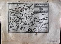
Westfalia. "
by Ortelius, Abraham
- Used
- first
- Condition
- Used
- Quantity Available
- 1
- Seller
-
Nafplion, Greece
- Item Price
-
$32.43
Show Details
Description:
Europe: Antwerp Joannem Bapt. Vrientium/ Vrients. 1601. Copper engraved minature map by Phillip Galle of Westphalia, Germany, from" Epitome theatri Orteliani praecipuarum orbis regionum delinaetiones. . Editio ultima" Latin text to verso, describing the succeeding map. . Dark impression, overall toning, light foxing to blank margins. Light dampstaining to blank margins. The first edition of the"Epitome" in 1577, a reduced format atlas, with minature maps of Abraham Ortelius's "Theatrum" is believed to have been the initiative of the engraver Phillip Galle who asked Peter Heyns to write the text. Ortelius had fled to England in 1576 having taken refuge there from Spanish oppression, and may have been unaware of the plan of his two friends. The pocket atlas was a a commmercial success and was reprinted several times with Galle adding many new maps, and replacing some. Jan. Baptist, Vrients bought the rights and plates of the Epitome from Phillip Galle in 1601, . he published 4 editions using the…
Read More Item Price
$32.43

Veromandui. "
by Ortelius, Abraham
- Used
- first
- Condition
- Used
- Quantity Available
- 1
- Seller
-
Nafplion, Greece
- Item Price
-
$32.43
Show Details
Description:
Europe: Antwerp Joannem Bapt. Vrientium/ Vrients. 1601. Copper engraved minature map by Phillip Galle of the area around St. Quentin & Pérrone. known as Vermandois, France, from" Epitome theatri Orteliani praecipuarum orbis regionum delinaetiones. . Editio ultima" Latin text to verso, describing the succeeding map. . Dark impression; overall toning; light foxing/staining to blank margins; printed crooked on the page. heading shaved, and upper margin very short2-6mm. The first edition of the"Epitome" in 1577, a reduced format atlas, with minature maps of Abraham Ortelius's "Theatrum" is believed to have been the initiative of the engraver Phillip Galle who asked Peter Heyns to write the text. Ortelius had fled to England in 1576 having taken refuge there from Spanish oppression, and may have been unaware of the plan of his two friends. The pocket atlas was a a commmercial success and was reprinted several times with Galle adding many new maps, and replacing some. Jan. Baptist, Vrients bought the…
Read More Item Price
$32.43

Blesiense Territorium. "
by Ortelius, Abraham
- Used
- first
- Condition
- Used
- Quantity Available
- 1
- Seller
-
Nafplion, Greece
- Item Price
-
$32.43
Show Details
Description:
Europe: Antwerp Joannem Bapt. Vrientium/ Vrients. 1601. Copper engraved minature map by Phillip Galle of Blois, France, from" Epitome theatri Orteliani praecipuarum orbis regionum delinaetiones. . Editio ultima" Latin text to verso, describing the succeeding map. . Dark impression; overall toning; light foxing/staining to blank margins. The first edition of the"Epitome" in 1577, a reduced format atlas, with minature maps of Abraham Ortelius's "Theatrum" is believed to have been the initiative of the engraver Phillip Galle who asked Peter Heyns to write the text. Ortelius had fled to England in 1576 having taken refuge there from Spanish oppression, and may have been unaware of the plan of his two friends. The pocket atlas was a a commmercial success and was reprinted several times with Galle adding many new maps, and replacing some. Jan. Baptist, Vrients bought the rights and plates of the Epitome from Phillip Galle in 1601, . he published 4 editions using the Galle plates of which this is the…
Read More Item Price
$32.43

Delphinatus. " "Auaicus Principatus
by Ortelius, Abraham
- Used
- first
- Condition
- Used
- Quantity Available
- 1
- Seller
-
Nafplion, Greece
- Item Price
-
$32.43
Show Details
Description:
Europe: Antwerp Joannem Bapt. Vrientium/ Vrients. 1601. Copper engraved minature map by Phillip Galle of Duphiné, France, from" Epitome theatri Orteliani praecipuarum orbis regionum delinaetiones. . Editio ultima" Latin text to verso, describing the succeeding map. . Dark impression; overall toning; light foxing/staining to blank margins. The first edition of the"Epitome" in 1577, a reduced format atlas, with minature maps of Abraham Ortelius's "Theatrum" is believed to have been the initiative of the engraver Phillip Galle who asked Peter Heyns to write the text. Ortelius had fled to England in 1576 having taken refuge there from Spanish oppression, and may have been unaware of the plan of his two friends. The pocket atlas was a a commmercial success and was reprinted several times with Galle adding many new maps, and replacing some. Jan. Baptist, Vrients bought the rights and plates of the Epitome from Phillip Galle in 1601, . he published 4 editions using the Galle plates of which this is the…
Read More Item Price
$32.43

Turonensis Ducatus. "
by Ortelius, Abraham
- Used
- first
- Condition
- Used
- Quantity Available
- 1
- Seller
-
Nafplion, Greece
- Item Price
-
$32.43
Show Details
Description:
Europe: Antwerp Joannem Bapt. Vrientium/ Vrients. 1601. Copper engraved minature map by Phillip Galle of Touraine, France, from" Epitome theatri Orteliani praecipuarum orbis regionum delinaetiones. . Editio ultima" Latin text to verso, describing the succeeding map. . Dark impression; overall toning; light foxing/staining to blank margins. The first edition of the"Epitome" in 1577, a reduced format atlas, with minature maps of Abraham Ortelius's "Theatrum" is believed to have been the initiative of the engraver Phillip Galle who asked Peter Heyns to write the text. Ortelius had fled to England in 1576 having taken refuge there from Spanish oppression, and may have been unaware of the plan of his two friends. The pocket atlas was a a commmercial success and was reprinted several times with Galle adding many new maps, and replacing some. Jan. Baptist, Vrients bought the rights and plates of the Epitome from Phillip Galle in 1601, . he published 4 editions using the Galle plates of which this is the…
Read More Item Price
$32.43

Aniou. " "Andegavensis Ducatus
by Ortelius, Abraham
- Used
- first
- Condition
- Used
- Quantity Available
- 1
- Seller
-
Nafplion, Greece
- Item Price
-
$32.43
Show Details
Description:
Europe: Antwerp Joannem Bapt. Vrientium/ Vrients. 1601. Copper engraved minature map by Phillip Galle of Anjou, France, from" Epitome theatri Orteliani praecipuarum orbis regionum delinaetiones. . Editio ultima" Latin text to verso, describing the succeeding map. . Dark impression, overall toning, light foxing to blank margins; one darker spot to lower blank margin The first edition of the"Epitome" in 1577, a reduced format atlas, with minature maps of Abraham Ortelius's "Theatrum" is believed to have been the initiative of the engraver Phillip Galle who asked Peter Heyns to write the text. Ortelius had fled to England in 1576 having taken refuge there from Spanish oppression, and may have been unaware of the plan of his two friends. The pocket atlas was a a commmercial success and was reprinted several times with Galle adding many new maps, and replacing some. Jan. Baptist, Vrients bought the rights and plates of the Epitome from Phillip Galle in 1601, . he published 4 editions using the Galle…
Read More Item Price
$32.43

Caletum et Bononia. "
by Ortelius, Abraham
- Used
- first
- Condition
- Used
- Quantity Available
- 1
- Seller
-
Nafplion, Greece
- Item Price
-
$32.43
Show Details
Description:
Europe: Antwerp Joannem Bapt. Vrientium/ Vrients. 1601. Copper engraved minature map by Phillip Galle of the Pas-de Calais, France, from" Epitome theatri Orteliani praecipuarum orbis regionum delinaetiones. . Editio ultima" Latin text to verso, describing the succeeding map. . Dark impression; overall toning; light foxing/staining to blank margins. The first edition of the"Epitome" in 1577, a reduced format atlas, with minature maps of Abraham Ortelius's "Theatrum" is believed to have been the initiative of the engraver Phillip Galle who asked Peter Heyns to write the text. Ortelius had fled to England in 1576 having taken refuge there from Spanish oppression, and may have been unaware of the plan of his two friends. The pocket atlas was a a commmercial success and was reprinted several times with Galle adding many new maps, and replacing some. Jan. Baptist, Vrients bought the rights and plates of the Epitome from Phillip Galle in 1601, . he published 4 editions using the Galle plates of which this…
Read More Item Price
$32.43

Campania. "
by Ortelius, Abraham
- Used
- first
- Condition
- Used
- Quantity Available
- 1
- Seller
-
Nafplion, Greece
- Item Price
-
$32.43
Show Details
Description:
Europe: Antwerp Joannem Bapt. Vrientium/ Vrients. 1601. Copper engraved minature map by Phillip Galle of Champagne, France, from" Epitome theatri Orteliani praecipuarum orbis regionum delinaetiones. . Editio ultima" Latin text to verso, describing the succeeding map. . Dark impression; overall toning; light foxing/staining to blank margins. The first edition of the"Epitome" in 1577, a reduced format atlas, with minature maps of Abraham Ortelius's "Theatrum" is believed to have been the initiative of the engraver Phillip Galle who asked Peter Heyns to write the text. Ortelius had fled to England in 1576 having taken refuge there from Spanish oppression, and may have been unaware of the plan of his two friends. The pocket atlas was a a commmercial success and was reprinted several times with Galle adding many new maps, and replacing some. Jan. Baptist, Vrients bought the rights and plates of the Epitome from Phillip Galle in 1601, . he published 4 editions using the Galle plates of which this is the…
Read More Item Price
$32.43