West Indische Paskaert by LOOTS, Johannes (ca. 1665 - 1726) - BLAEU, Willem (1571-1638) - GOOS, Pieter (1615-1675)
by LOOTS, Johannes (ca. 1665 - 1726) - BLAEU, Willem (1571-1638) - GOOS, Pieter (1615-1675)
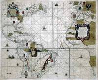
West Indische Paskaert
by LOOTS, Johannes (ca. 1665 - 1726) - BLAEU, Willem (1571-1638) - GOOS, Pieter (1615-1675)
- Used
- first
Amsterdam: Joannes Loot, [ca. 1695]. 2 sheets joined, float-mounted and framed (42 x 49 inches; sheet size: 33 2/8 x 39 6/8 inches, full margins, showing the plate mark). AN EXCEPTIONALLY FINE engraved map of the Atlantic Ocean, showing the eastern seaboard of North America, the Gulf of Mexico, northern South America, with an inset of the tip of South America within an asymmetrical rococo cartouche, western Europe, Spain, and western Africa, the main title within an elaborate allegorical cartouche centre right, the Goos imprint within another upper left, decorated with the arms of the colonial powers, 3 compass roses, many galleons and a sea monster, with original hand-colour in part. THE FIRST SEA CHART RELATING TO NORTH AMERICA TO USE GERARD MERCATOR'S PROJECTION. First published by Willem Blaeu in about 1630, this edition is Burden's State 4, with Loots' imprint. The copperplate for the map passed through the hands of Jacob Robijn, who probably acquired it at one of the sales of the Blaeus stock in 1674, to Pieter Goos and lastly Loots. Although changes were made to the cartouches, the geographical content of the sea chart remains unchanged. Blaeu here attempts to improve the depiction of the area between New York Harbor and Chesapeake Bay, one which confused Blaeu in his first Paskaert (1621). However, he abandons Delaware Bay altogether, retrieving the old favorite C. de las Arenas. The map extends from Ireland to Newfoundland in the north and to the Cape of Good Hope and Rio de la Plata in the south, and from the Gulf of Mexico in the west to Greece in the east. It is probable that the sea chart was originally intended for the sole use of the Dutch West India Company and the map shows the area chartered to the Company in 1621. The latest geographical information included is derived from the voyage of the Admiral LHermite to Tierra del Fuego between 1623 and 1626. The map extends from Ireland to New-Foundland in the north and to the Cape of Good Hope and Rio de la Plata in the south, and from the Gulf of Mexico in the west to Greece in the east. An inset map in the interior of South America shows that part of the continent which could not be included in the main map. Even by the latter part of the seventeenth century, this map remained enormously important for Western navigation to Brazil, because it was only in 1685 that the first charts of the Brazilian coast were published by Robijn. While this map, with its network of rhumb lines indicating bearings, bears a close resemblance to previous sea charts, it was based on an entirely different geometric projection, developed by Mercator. Prior to this major innovation, medieval and Renaissance sea charts had not been drawn on any projection. They lacked indications of latitude or longitude as well as consistent orientation. While such portolan charts were highly effective in allowing mariners to chart a course from one port to another - directions, indicated by intricate networks of rhumb lines, tended to be remarkably accurate - distances were shown approximately at best. Moreover, these earlier sea charts did not take into account the curvature of the earth, and even bearings were subject to significant distortion once the distances involved extended to the width of the Atlantic Ocean. Legendary Dutch cartographer William Janszoon Blaeu was a pupil of the great Danish astronomer Tycho Brahe, from whom he learned a very scientific approach to the field of cartography, which served to enhance his reputation. His early work concentrated on globe making, but by the early seventeenth century he began producing separately issued maps. Blaeu founded his publishing firm in 1596, and with the collaboration of his sons, Cornelius (1616-1648) and Joan (1596-1673), it was the most productive cartographic establishment in the Netherlands until it was destroyed by the Great Fire of 1672. Appointed mapmaker to the Dutch East India Company in 1633-1634, Blaeu had access to fresh geographical information that was not available to any of his contemporaries, and the unrivaled map collection of Petrus Plancius, who in addition to Dutch sources also, by way of espionage, in 1592-94 acquired manuscripts from Bartholemmeo de Lasso in Lisbon. He published his first world atlas, the 'Atlantis Appendix', with 60 maps in 1630, and continued to produce new maps at such a rate that by 1634, he abandoned the single volume format and announced his intention to publish a new world atlas, entitled the 'Theatrum', which eventually grew into the monumental 11-volume 'Atlas Maior', completed by his son Joan in 1662. Pieter Goos published the first edition of his "Zee-Spiegel" in 1650 with text and charts borrowed or bought from Theunis Jacobsz' which had been published as his "Lichtende Colonne ofte Zeespiegel" of 1644. The "Zee-Spiegel" includes maps of Europe, Great Britain and Ireland, the North Sea and the Scandinavian and Baltic coasts, as well as Iceland, Greenland, and the west and south coasts of Netherlands, France, Spain and Portugal, Barbary and the Canary Islands. The "Zee-Spiegel", or "Mirror of the Sea" was an exceedingly popular book, in 1650 Johannes Blaeu, Janssonius, Colom and the Jacobsz family were all publishing versions of this pilot, and by 1655 Doncker had joined the competition. However Goos' work seems to have been amongst the most successful: he published this book with few alterations (mostly to the short introduction to navigation and its Almanac) for 28 years, adding editions in English in 1658 and French in 1662. He added a Mediterranean section (by Lootsman) in 1662, and was the first to undertake a fourth (the coasts of West Africa eventually published in 1685) and fifth part (in 1675 containing charts of the West Indies). Schilder, Monumenta, Vol. IV, p.114, 63.4; Burden, The Mapping of North America, Map 233, State 4.
-
Bookseller
Arader Galleries
 (US)
(US)
- Book Condition Used
- Publisher Amsterdam: Joannes Loot, [ca. 1695].