Description:
Paris: Jaillot, 1695. VG, with only flaw some dampstaining at lower margin with expert verso paper reinforcement, not affecting main image (would mat well). Centerfold as issued; hand-colored. A very uncommon and attractive plate, with a small walled city view (birds-eye) of Vienna, with all surrounding villages (castles) marked. A nice image of the Danube is central here. Jaillot was originally a sculptor (see Moreland & Bannister: Antique Maps). The copperplate image is 18x25.5 inches. .
The English Atlas by PITT, Moses (ca. 1639-1697) - 1680
by PITT, Moses (ca. 1639-1697)
Similar copies are shown below.
Similar copies are shown to the right.
The English Atlas
by PITT, Moses (ca. 1639-1697)
- Used
- Fine
- Hardcover
- first
Printed at the Theater, for Moses Pitt at the Angel in St.. Pauls Church-Yard, London, 1680-1681-1683-1682, 1680. 4 volumes. Folio (21 4/8 x 14 inches). Letterpress title-pages, two printed in red and black and with small engraved vignettes, letterpress in volume one ruled in red throughout. Fine engraved portrait of Charles II, engraved by R. White, in volume one by (laid down on heavier stock at an early date) and double-engraved plate of Laplanders by F. van den Houe with magnificent original hand-colour in full, 3 further folding plates and 166 double-page maps of the world by John Seller and Janssonius and Northern Europe, all with original hand-colour in part, the cartouches with original hand-colour in full, those in volume one occasionally HEIGHTENED IN GOLD and gum arabic, all cartouches and other fine details in volume IV HEIGHTENED IN GOLD and gum arabic, all maps in this volume ruled in red (world map by Seller trimmed and laid down on heavier stock, volume one without map 35 'Ducatus Stomariae' and 40 'Regni Norvegiae'; map 35 in volume II 'Marchia Vetus' trimmed and laid down on heavier stock; volume III with maps 'Totius Sveviae', 'Walachia' and 'Iuliacensis Ducatus' trimmed and laid down, without map 126 'Diocesis Leodeniensi' but with additional map 'Oldenburg'; volume IV lacking map 141 'Fossa Eugeniana' but with additional map 'Namurcum Comitatus'). Fine contemporary blind paneled smooth and mottled calf, the spines in 8 compartments with 7 raised bands, one lettered in gilt, the others decorated with fine gilt tools (expertly rebacked preserving the original backstrips, a bit rubbed). Provenance: with the engraved armorial bookplate of George Tollet Esq. (d. 1719), mathematician and naval administrator, on the verso of each title-page; with the engraved armorial bookplate of the Weston Library of the Earls of Bradford on each front paste-down. First edition. The two world maps are John Seller's "Novissima Totius Terrarum Orbis Tabula..." (Shirley 460) and Pieter van den Keere's "Nova totius terrarum orbis geographica ac hydrographica tabula" in the revised Janssonius, post 1620, state (Shirley 504) with a dedication to the Bishop of Oxford in the upper left. The map of the North Pole is Janssonius's "Nova et accurata Poli Arctici" and not that of Moses Pitt. The remaining maps are of Northern and Eastern Europe, all based on Dutch cartography, as Pitt's intention had been to publish a mammoth atlas to rival that of Blaeu, "giving a reprise to many of the plates which Janssonius had acquired over the years, some of them going as far back as the stocks that were used for Mercator's Atlas" (Goss) . However, as with many grand publishing designs the venture faltered after only these four volumes. The maps in volume one, in addition to the world map, and that of the Arctic, are of Russia, Poland, and Scandinavia; volumes II and III are of the German Empire; and IV contains the Seventeen Provinces of the Low Countries, or Netherlands. Moses Pitt was neither a cartographer nor a scholar, yet in 1670 he undertook a project that came to be called 'The English Atlas'. Despite the seemingly difficult, if not unrealistic, task at hand--hardly mitigated by the paucity of skilled commercial cartographers in England--Pitt's endeavor was backed by Sir Christopher Wren and Robert Hooke, and his partners included the Dutch map publisher Jan Jansson and the Englishman Steven Stewart. Based on the concept of the Atlas Maior by Joan Blaeu ,Pitt's atlas was to consist of twelve volumes, but only four were completed (covering places "next to the North-pole," Muscovy, Poland, Sweden, Denmark, Germany and the seventeen provinces of the Low Countries). Pitt had envisioned the project as a reissue of a Dutch atlas in "English guise"--in which existing Dutch maps would be repackaged with accompanying text in English--whereas his partners envisioned the printing of an atlas with entirely new maps. Such conflicts, along with economic factors and the overly ambitious nature of the project envisioned, eventually led to its demise. After only four parts of the atlas were completed, Pitt was in financial ruin and was imprisoned for debt from 1689 to 1691. Nonetheless, the four volumes that were produced signal the sumptuous nature of the project, as the highest production values were lavished upon it in terms of engraving, paper and coloring. From the distinguished library of George Tollet, who in 1683 became a founder member of the Dublin Philosophical Society—"a sister organization to the Royal Society—and would become one of its more active members: his experiments and presentations, as well as his correspondence with other scientists, including Edmond Halley, are often remarked upon in its minute book, which records his election to the position of treasurer on 2 November 1685... several of Tollet's contributions to the Dublin society's meetings involved applied mathematics—he presented papers on gunnery and on longitude, for example—...In 1688 Tollet moved to England. Luttrell's parliamentary diary reports that Tollet was chosen secretary to the ‘commissioners for taking the public accounts’ in March 1691; was made ‘comptroller of the foreign post office in the room of Mr Brocket’ in May 1697; took a post at ‘the custome house’ in November 1697; and in June 1700 was made ‘secretary of the excise, worth £500 per annum’ (Luttrell, 2.192; 4.219, 306, 661). Not mentioned in Luttrell's diary, but noted by both Hinchliffe and Speake, is Tollet's appointment as accountant-general of Ireland, granted in December 1691" (Michael Londry for DNB). And from the library of the Earls of Bradford, probably Henry Bridgeman, first Baron Bridgeman (1725-1800) who inherited Weston Park from his mother's family in 1762. E. G. R. Taylor, "The English Atlas of Moses Pitt, 1680-83," Geographical Journal 95, 4 (April 1940), 292-299; Lloyd Arnold Brown, The World Encompassed, exh. cat. (Baltimore, 1952), n. 172; Rodney W. Shirley, The Mapping of the World (London, 1983), n. 504. Catalogued by Kate Hunter. 1st Edition. Full Leather. Fine. Atlas.
-
Bookseller
Arader Galleries
 (US)
(US)
- Format/Binding Hardcover
- Book Condition Used - Fine
- Edition 1st Edition
- Binding Hardcover
- Publisher Printed at the Theater, for Moses Pitt at the Angel in St.. Pauls Church-Yard, London, 1680-1681-1683-1682
- Date Published 1680
We have 7 copies available starting at $125.00.

(Map / Chart- Environs of Vienna, Austria): Plan de la Ville De Vienne en Austriche et Ses Environs
by Jaillot, Alexis-Hubert
- Used
- Condition
- Used
- Binding
- Unknown
- Quantity Available
- 1
- Seller
-
Crozet, Virginia, United States
- Item Price
-
$595.00
Show Details
Item Price
$595.00

(Map of Holy Land- Canaan): Canaan
by Speed (Speede), John
- Used
- first
- Condition
- Used
- Binding
- Unknown
- Quantity Available
- 1
- Seller
-
Crozet, Virginia, United States
- Item Price
-
$1,495.00
Show Details
Description:
London: Christopher Browne (at the Globe near the West End of St. Pauls Church), 1695. Good, hand colored outlines, This is the Christopher Browne imprint (see Roderick M. Barron's description in his catalogue 33 as to the recent discovery of this imprint, separate from the more commonly reported Bassett and Chiswell 1676 plate), which may be more common than initially thought. Browne published a bit later, and had purchased the Bassett and Chiswell plates, then changed the name on a few of those (of which this plate was one; very few survive), and the date here is approximate. This is a striking image with Jerusalem inset, newly updated and published in the 1676 edition (date approximate) of Speed's " A Prospect of the Most Famous Parts of the World". There is some general browning, with some professional restorations at folds (virtually no image loss), mild upper margin staining (mostly in blank areas) and backed with Japon paper. A custom case was made for this map, after…
Read More Item Price
$1,495.00
More Photos
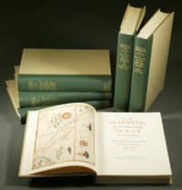
Mapping the Transmississippi West, 1540–1861,
by Wheat, Carl Irving (1892-1966)
- Used
- near fine
- Hardcover
- first
- Condition
- Used - Near Fine
- Edition
- First
- Binding
- Hardcover
- Quantity Available
- 1
- Seller
-
Fort Worth, Texas, United States
- Item Price
-
$2,750.00
Show Details
Description:
From the Spanish discovery to the opening of the Civil War5 volumes in 6. Volume One: The Spanish Entrada to the Louisiana Purchase 1540-1804 xiv+264 pages with color frontispiece map and 275 maps (many folding) and index; Volume Two: From Lewis and Clark to Fremont 1804-1845 xiii+281 pages with colored frontispiece map, 143 additional maps (some folding) and index. Volume Three: From the Mexican War to the Boundary Surveys 1846-1854 xiii+349 pages with colored frontispiece map, 322 additional maps and index; Volume Four: From the Pacific Railroad Surveys to the Onset of the Civil War 1855-1860 xiii+260 pages with color frontispiece map, an additional 127 maps (some folding) and index; Volume Five From the Civil War to the Geological Survey, Part One: xviii+222 pages with color frontispiece map and an additional 152 maps; Volume Five From the Civil War to the Geological Survey, Part Two: [223]-487 pages with 124 maps and index. Folio (14 1/2" x 10 1/2") bound in quarter green leather with gilt…
Read More Item Price
$2,750.00

Territorium Bononiense il Bolognese
by Johanne Janssonius AKA Jan Jansson
- Used
- very good
- Condition
- Used - Very Good
- Quantity Available
- 1
- Seller
-
Fort Lauderdale, Florida, United States
- Item Price
-
$550.00
Show Details
Description:
Anmstedam: Johanne Janssonius. Very Good. c. 1640. 17th century map with original, hand-colored outlines of Bologna, Italy. Decorative cartouche. Latin text to verso with historiated initial. Please see image. Plate size approximately 21 1/4 x 17 in. Overall size approx. 21 x 18 in (545 x 450 mm).; All shipments through USPS insured Priority Mail. .
Item Price
$550.00
![Upper Mines Nos. 1 & 8 [and] Lower Mines No. 3 or Mormon Diggings; [Both on single sheet]...](https://d3525k1ryd2155.cloudfront.net/h/575/126/1453126575.0.m.jpg)
More Photos
Upper Mines Nos. 1 & 8 [and] Lower Mines No. 3 or Mormon Diggings; [Both on single sheet] [included in 30th Congress, Second Session, House, Executive Document No. 1, Message from the President ... James K. Polk, December 5 1848]
by Mason, Richard B. [James K. Polk]
- Used
- very good
- first
- Condition
- Used - Very Good
- Edition
- First Edition
- Binding
- Unknown
- Quantity Available
- 1
- Seller
-
Sebastopol, California, United States
- Item Price
-
$392.00
Show Details
Description:
Washington DC: Government Printing Office, 1848. First Edition. Very Good. [Sheet 10.5x8.25in, Neat line Upper 4.75x6.25in and Lower 4.125x6.25in]; The map shows the location of the Upper Mines Nos. 1 & 8 diggings along the South Fork of the American river, with roads buildings, including Shutter's Saw Mill and Marshall's house and distance to Sutters [Fort]. The Lower Mines No.3 or Mormon Diggings are also along the river and shows the Mormon Bar and labels the gold deposits, the store and road to Sutters. [Wheat Maps 52, Poore p. 567]. Richard Barnes Mason (1797-1850) was a United States Army officer and the fifth Military Governor of California (1847-1849). After gold was discovered by James Marshall at Sutter's Mill in January 1848, General Mason toured the Gold diggings along the American River north east of Sacramento in June, 1848. The report was written in Monterey in August 17, 1848. The Mason reports and maps were part of a larger Federal report to Congress on a number of subjects that…
Read More Item Price
$392.00

More Photos
SMITH'S MAP OF PHILADELPHIA AND VICINITY
by Gannett, Henry; Chief Topographer, U. S. Geological Survey
- Used
- Hardcover
- first
- Condition
- Used - Good+
- Edition
- First Edition Thus; Second Printing
- Binding
- Hardcover
- Quantity Available
- 1
- Seller
-
Fairfield, New Jersey, United States
- Item Price
-
$175.00
Show Details
Description:
Philadelphia: J. L. Smith. Good+. 1904. First Edition Thus; Second Printing. Hardcover. U. S. Geological Survey, surveyed in 1894, edition of 1902, printed in 1904. This is a 30 1/2" x 38 1/2" USGS map that J. L. Smith of Philadelphia, sometime after issue, sectioned (4 sections x 6 sections) and mounted on linen to create a folding pocket map. It is mounted in a 10 x 5.5 inch dark brown embossed and gilded hardcover folder that bears the title "Smith's Map of Philadelphia and Vicinity". The map covers the area north and west well past Norristown and south into Delaware, as well as a good part of New Jersey beyond Camden. It shows the local road network and was made for local travel. The inside cover has original owner's signature. Cover graded G+ due to rubbing along the spine edges & corners. The map is in VG condition. ; Fold out cloth Map; Small 4to 9" - 11" tall .
Item Price
$175.00

More Photos
The Albert Nyanza, great basin of the Nile and explorations of the Nile Sources
by BAKER, Samuel White
- Used
- near fine
- Hardcover
- first
- Condition
- Used - Near Fine
- Edition
- first
- Binding
- Hardcover
- Quantity Available
- 1
- Seller
-
COLUMBIA, Missouri, United States
- Item Price
-
$499.00
Show Details
Description:
1866 1edAlbert Nyanza Nile Tributaries AFRICA
Egypt Abyssinia Samuel Baker Maps
Samuel White Baker was an English explorer and was the first Englishman to sit in a high office of the Egyptian government. Many of Baker's works shed light on the horrors of slave owners and slave trade in central Africa. His works, however, also centralized on Egypt and the Abyssinia Nile tributaries. He had an extensive knowledge of Egypt as he held important political officers in Egypt.
His accounts of Egypt and the Nile River Basin are some of the most important 19th-century books on the Nile River and helped record the discovery of Lake Albert. 'The Albert N'yanza, Great Basin of the Nile' is Baker's account of his discovery of the last great source of the Nile.
Item number: #10917
Price: $499
BAKER, Samuel White
The AlbertNyanza, great basin of the Nile and explorations of the Nile Sources
London : Macmillan ; Philadelphia : J.B. Lippincott, 1866. First edition.
Details:
· Collation: Complete with all… Read More
Item Price
$499.00

More Photos
Histoire des révolutions de Perse depuis le commencement de ce siècle jusqu'à la fin du règne de l'usurpateur Aszraff.
by CERCEAU, Jean-Antoine du [attributed]
- Used
- near fine
- Hardcover
- Condition
- Used - Near Fine
- Binding
- Hardcover
- Quantity Available
- 1
- Seller
-
COLUMBIA, Missouri, United States
- Item Price
-
$599.00
Show Details
Description:
1742 History of PERSIA Revolutions Nader Shah Kouli Khan Iran MAP Middle East 2vJean-Antoine du Cerceau was a 17th-century French Jesuit poet whose works were quite popular amongst noble courts. He is best known for his poems, plays, and short stories, but he also wrote an important work on the history of the Persian revolutions and the reign of Qoli Khan, the Nader Shah. This work, which is also sometimes attributed to Andre Claustre, covers the history of Iran, Afghanistan, and Persia, religious and cultural customs, and Middle Eastern geography.
This book also discusses the reign of Qoli Khan himself, his corrupt power, and the revolts and assassination against him. Note the impressive folding map.
Item number: #12308
Price: $599
CERCEAU, Jean-Antoine du [attributed]
Histoire des révolutions de Perse depuis le commencement de ce siècle jusqu'à la fin du règne de l'usurpateur Aszraff.
Paris : Briasson, 1742.
Details:
·
Collation: Complete with all pages; 2 volumes
o
Vol. 1 –… Read More
Item Price
$599.00

More Photos
Cosmographie élémentaire : divisée en parties astronomique et géographique
by MENTELLE, Edme
- Used
- near fine
- Hardcover
- Condition
- Used - Near Fine
- Binding
- Hardcover
- Quantity Available
- 1
- Seller
-
COLUMBIA, Missouri, United States
- Item Price
-
$750.00
Show Details
Description:
1785 Cosmographia Geography Color MAPS ATLAS Astronomy Physics Asia Africa USAEdme Mentelle was an 18th-century French geographer best-known for his book 'Elementary Cosmographia'. In this book, Mentelle describes the basics of geography and geographic mathematics covering latitude and longitude, world climates, differences in bodies of water, etymology of Asia and Africa, political climate of world nations and powers, with attention given to the Americas, Egypt, France, and many others! Other notable contents include instruction on astrology and astronomy.
Note the inclusion of impressive, folding engraved maps and illustrations throughout!
Item number: #20230
Price: $750
MENTELLE, Edme
Cosmographie élémentaire : divisée en parties astronomique et géographique
A Paris : Chez l'auteur, 1785.
Details:
· Collation: Complete with all pages
o xxxii, 558, [2]
o
13 maps and folding engravings
· Language: French
· Binding: Leather; tight and secure
· Size: ~8in X… Read More
Item Price
$750.00
More Photos
A complete genealogical, historical, chronological and geographical atlas: Lavoisne Atlas
by C V Lavoisne
- Used
- very good
- Hardcover
- Condition
- Used - Very Good
- Jacket Condition
- none
- Edition
- 2nd
- Binding
- Hardcover
- Quantity Available
- 1
- Seller
-
Dixon, Illinois, United States
- Item Price
-
$2,500.00
Show Details
Description:
C V Lavoisne; C Gros; Jehoshaphat Aspin; E PaguenaudA complete genealogical, historical, chronological and geographical atlas; being a general guide to history, both ancient and modern: exhibiting an accurate account of the origin, descent, and marriages of all the royal families . the whole forming a complete system of history and geographyPhiladelphia, Published by M. Carey and Son; printed by T.H. Palmer, 1820-01-01. 2nd American ed., carefully rev. Hardcover. Good. Second American edition, published in the same year as the first American edition. Folio, 46 x 34 cm, (17 1/2 x 11 7/8 inches). Bound with contemporary gilt letter spine over boards. Good condition for being an 1820's copy. Beautiful marbled paper over boards both outside and inside covers. Original spine still holding except for a split at the bottom and a small chunk missing. See Pic. Sought after John Melish United States map in the back. Some paper loss on the title page with some small holes. Maps are in very good condition with a…
Read More Item Price
$2,500.00

The English Atlas. Volume 1. Containing a Description of the Places Next to the North-Pole; as Also of Muscovy, Poland, Sweden, Denmark, and Their several Dependances
by Pitt, Moses; O. Halecki (introduction)
- Used
- Paperback
- Condition
- Used - g+ to near fine
- Edition
- Reprint
- Binding
- Paperback
- Quantity Available
- 1
- Seller
-
Santa Monica, California, United States
- Item Price
-
$125.00
Show Details
Description:
New York: Z. Tebinka, 1943. Reprint. Softcover. g+ to near fine. Large elephant folio. [2] 28pp. Half red cloth over illustrated tan paper wrappers, with black lettering on the front cover. This work is a full and finely produced facsimile reprint of the incredibly scarce "English Atlas," originally created and published by Moses Pitt (c. 1639-1697), in Oxford 1680. Only the first volume of the set is reprinted here, focusing on Northern regions including Russian, Poland and Scandinavia. Originally Pitt had intended to issue a 12 volume set, all under the auspices of the Royal Society, but ultimately only was able to issue 4 volumes before the project collapsed due to financial difficulties. The work contains 4 detailed fold-out maps each measuring 23x22", showing Poland, Lithuania, Ukraine and Western areas of Russia during the period. Text throughout printed in a two-column format. Introductory text at the front of the reprint, discussing the history of the work. Wrappers with some age toning to…
Read More Item Price
$125.00

The English Atlas. Volume II. ENGRAVED TITLE PAGE.
by Pitt, Moses
- Used
- Condition
- Used
- Quantity Available
- 1
- Seller
-
Fallon, Nevada, United States
- Item Price
-
$200.00
Show Details
Description:
[London:], 1681.. 27 x 40.5cm. Single leaf.. Engraved title page to volume two, trimmed just outside borders. Minor tape remnants on left border. Mounted on larger plain leaf. Suitable for framing. Fine engraved title page to volume 2, with German Emperor and his courtiers, surmounted by German double-headed eagle, and coat of arms.
Item Price
$200.00
![[Title-page] The English Atlas, Volume II](https://d3525k1ryd2155.cloudfront.net/h/989/308/139308989.0.m.jpg)
[Title-page] The English Atlas, Volume II
by Pitt, Moses:
- Used
- Condition
- Used
- Quantity Available
- 1
- Seller
-
London, United Kingdom
- Item Price
-
$409.47
Show Details
Description:
London, 1681. Copper engraved title-page, 40.5 x 26.5 cms, black and white as issued, blank verso. Four volumes only of Pitt’s projected eleven volume world atlas were published 1680-83, all dealing with northern Europe. Pitt worked in partnership with Janssonius’ heir Joannes van Waesbergen, and this title-page for the German volume is a reworking of one engraved for Janssonius forty years earlier. The Holy Roman Emperor is now Leopold I, the faces of the other Electors have also been updated, and a there is a considerable amount of additional background detail. Shirley, Courtiers and Cannibals, 48A. Map
Item Price
$409.47
The English Atlas. TITLE PAGE ENGRAVING.
by Pitt, Moses
- Used
- first
- Condition
- Used
- Edition
- From the first edition.
- Quantity Available
- 1
- Seller
-
Fallon, Nevada, United States
- Item Price
-
$500.00
Show Details
Description:
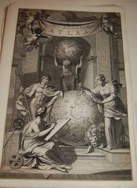
[Oxford:]: [for J, Jansonius a Waesberge, Moses Pitt and Steven Swart,], [1680].. From the first edition.. 46 x 29.5cm.. Stunning, large allegorical title page by J. van Munnikhuysen after Zacharias Webbers. Trimmed at borders. Few minor edge tears, repaired, top one just barely touching cherub, no true affect to the illustration, overall it is a beautiful piece from a very rare and important. Most suitable for framing. Mounted on larger plain leaf. Based on the concept of Atlas Major by Joan Blaeu, PittÕs atlas was to be made of twelve volumes, but only four were completed when Pitt was imprisoned for debt. The title page illustrates mythical figures Neptune at the left of a large globe, and Cybele, Mother Godess of Earth at the right, with lion at her feet, in the background Atlas is shown holding a celestial globe on his shoulders, a seated muse is in front representing history. Wing P2306. NMM 410.
Item Price
$500.00
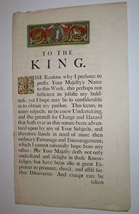
Dedication page to Charles II from The English Atlas. First edition.
by Pitt, Moses
- Used
- Condition
- Used
- Quantity Available
- 1
- Seller
-
San Francisco, California, United States
- Item Price
-
$500.00
Show Details
Description:
London: Printed at the Theater, for Moses Pitt , 1680. Letterpress with 2 engravings: Portrait of the king and inhabited initial, both handcolored. 57.5 x 33.5cm.
Item Price
$500.00
The English Atlas. Volume 1. Containing a Description of the Places next the North-Pole; as also of Muscovy, Poland, Sweden, Denmark, and their several dependences
by Pitt, Moses and Oskar Halecki
- Used
- Hardcover
- Condition
- Used - Collectible - Acceptable
- Binding
- Hardcover
- Quantity Available
- 1
- Seller
-
Frederick, Maryland, United States
- Item Price
-
$2,193.68
Show Details
Description:
Z. Tehinka. Collectible - Acceptable. New York: Z. Tehinka, 1943. Reprint of 1680 edition. Volume 1. Folio. 28pp. Maps. Fair book. Bottom 6" of both boards dampstained. (Poland, maps, history, travel) Inquire if you need further information.
Item Price
$2,193.68
The English Atlas. Volume 1. Containing a Description of the Places next the North-Pole; as also of Muscovy, Poland, Sweden, Denmark, and their several dependances
by Pitt, Moses and Oskar Halecki
- Used
- Condition
- Used - Collectible - Acceptable
- Quantity Available
- 1
- Seller
-
Frederick, Maryland, United States
- Item Price
-
$2,193.68
Show Details
Description:
Z. Tehinka. Collectible - Acceptable. New York: Z. Tehinka, 1943. Reprint of 1680 edition. Volume 1. Folio. 28pp. Maps. Fair book. Spine cover missing. Board covers considerably chipped, though without text loss. Front board detached. Preface through p. 26 detached. (Poland, maps, history, travel) Inquire if you need further information.
Item Price
$2,193.68

More Photos
The Sky and the Forest
by Forester, C.S
- Used
- very good
- Hardcover
- first
- Condition
- Used - Very Good
- Jacket Condition
- Very Good
- Edition
- First Edition
- Binding
- Hardcover
- Quantity Available
- 1
- Seller
-
Salem, Oregon, United States
- Item Price
-
$34.89$20.93Save $13.96!
Show Details
Description:
C.S. Forester: The Sky and the Forest. Little, Brown and Company, Boston. Stated First Edition First Printing Thus August, 1948. Cover price $2.75. Used. VG BOOK/VG UNCLIPPED DUST JACKET. A story of a central Africa. By C.S. Forester, author of the Admiral Hornblower series.
Item Price
$34.89$20.93
Save $13.96
!
![Alaska and Klondike Region; [With inset of Klondike Region on the Upper Yukon detail] [From an...](https://d3525k1ryd2155.cloudfront.net/h/062/537/1339537062.0.m.jpg)
Alaska and Klondike Region; [With inset of Klondike Region on the Upper Yukon detail] [From an atlas, "Gazetteer of Alaska and Yukon Region " pp. 105 and 106]
by Miller, J. Martin
- Used
- very good
- Condition
- Used - Very Good
- Edition
- Unknown
- Quantity Available
- 1
- Seller
-
Sebastopol, California, United States
- Item Price
-
$39.00
Show Details
Description:
Chicago: J. Martin Miller, 1899. Unknown. Map. Very Good. [Map copyright 1899, printing date of Atlas later] [19.875x15.125in]; Colored map of Alaska with steamer routes from Portland and Seattle, insets of the Klondike Region on the Upper Yukon and Western portion of Aleutian Islands; On verso index of places and names with two large black and white images; Age toning to all edges, water stain marks on bottom, slight printing offset of colors, small chips and closed tears to lower edge;.
Item Price
$39.00

Zemepis Sveta - Monsunova Asie
by De La Blache, P. Vidal; Gallois, L
- Used
- Hardcover
- Condition
- Used - Very Good Condition
- Jacket Condition
- No Dust Jacket
- Binding
- Hardcover
- Quantity Available
- 1
- Seller
-
Oak Point, Texas, United States
- Item Price
-
$60.00
Show Details
Description:
Aventinum, Prague, Czechoslovakia, 1931. Hardcover. Very Good Condition/No Dust Jacket. Text entirely in Czech. Geography book on Asia with numerous photographs and maps. 1930 edition also available. Size: 4mo - over 9 3/4" - 12" tall. 400 pp. Pages are yellowed, but are tight and clean. Moderate shelfwear along the spine. Corners are lightly bumped. Quantity Available: 1. Shipped Weight: 3-5 pounds. Category: Travel & Places; Non-English Language::Czech; Pictures of this item not already displayed here available upon request. Inventory No: 001228. . Additional shipping charges may apply.
Item Price
$60.00

Zemepis Sveta - Monsunova Asie
by De La Blache, P. Vidal; Gallois, L
- Used
- Hardcover
- Condition
- Used - Very Good Condition
- Jacket Condition
- No Dust Jacket
- Binding
- Hardcover
- Quantity Available
- 1
- Seller
-
Oak Point, Texas, United States
- Item Price
-
$60.00
Show Details
Description:
Aventinum, Prague, Czechoslovakia, 1930. Hardcover. Very Good Condition/No Dust Jacket. Text entirely in Czech. Geography book on Asia with numerous photographs and maps. 1931 edition also available. Size: 4mo - over 9 3/4" - 12" tall. 400 pp. Pages are yellowed, but are tight and clean. Moderate shelfwear along the spine. Corners are lightly bumped. Quantity Available: 1. Shipped Weight: 3-5 pounds. Category: Travel & Places; Non-English Language::Czech; Pictures of this item not already displayed here available upon request. Inventory No: 001227. . Additional shipping charges may apply.
Item Price
$60.00

North America from the Best Authorities, Russell, ca.1800
by Russell
- Used
- Condition
- Used
- Quantity Available
- 1
- Seller
-
Plymouth, Devon, United Kingdom
- Item Price
-
$25.20
Show Details
Description:
Russell, J. : A General Map of North America from the Best Authorities. Nd but ca.1800. From "A New Geographical, Historical and Commercial Grammar and Present State of Several Kingdoms of the World." Copper engraving. Size approx 200 x 230mm. Two neat folds. Some age colouring to edges, otherwise very clean and bright.
Item Price
$25.20

Asia from the Best Authorities, Russell, ca.1800
by Russell
- Used
- Condition
- Used
- Quantity Available
- 1
- Seller
-
Plymouth, Devon, United Kingdom
- Item Price
-
$25.20
Show Details
Description:
Russell, J. : Asia from the Best Authorities. Nd but ca.1800. From "A New Geographical, Historical and Commercial Grammar and Present State of Several Kingdoms of the World". Copper engraving. Size approx 200 x 230mm. Two neat folds. Some age colouring to edges, otherwise clean and bright. Includes Arabia, India, Borneo, Japan, China and eastern Russia.
Item Price
$25.20
![MAP OF UTAH [Territory]](https://d3525k1ryd2155.cloudfront.net/h/836/461/1485461836.0.m.jpg)
More Photos
MAP OF UTAH [Territory]
- Used
- Condition
- Used - Very Good-
- Edition
- Original
- Quantity Available
- 1
- Seller
-
Williamsburg, Virginia, United States
- Item Price
-
$65.00
Show Details
Description:
New York, Richmond, Chicago, & Toledo: H. H. Hardesty, 1885. Original color lithographed map printed by Rand, McNally & Company, Engravers and published in HARDESTY'S HISTORICAL AND GEOGRAPHICAL ENCYCLOPEDIA: SPECIAL VIRGINIA EDITION. 19 3/8 inches by 13 1/4 inches on a 21" X 14 1/2" sheet. The map depicts the Territory of Utah in its final form--large areas had been removed and ceded to Nevada, Colorado, Wyoming, and Nebraska since Utah became a U. S. Territory in 1850. The issue of polygamy prevented statehood until it was finally granted in 1896. This map features railroads and topography and uses color to set off counties from each other. Unlike most atlas maps of the period, this map identifies most small towns. The map is guaranteed to be moe than 135 years old. The map is in about very good condition: generally clean and bright, with slight toning of paper and one faint water stain near the center-left edge of the map.. Original. Single Sheet. Very Good-. Elephant…
Read More Item Price
$65.00

Last Tales
by Dinesen, Isak
- Used
- very good
- Hardcover
- first
- Condition
- Used - Very Good
- Jacket Condition
- Good+
- Edition
- First Edition
- Binding
- Hardcover
- Quantity Available
- 1
- Seller
-
Salem, Oregon, United States
- Item Price
-
$120.00$72.00Save $48.00!
Show Details
Description:
Dinesen, Isak: Last Tales, A Collection of Twelve New Tales of Compelling Beauty 1957, Random House. First Edition. Stated First Printing Thus. Used. Very Good/Good+ original red dust jacket, price-clipped. Jacket states 11/57 on front flap. 5 3/4 X
Item Price
$120.00$72.00
Save $48.00
!

Philips Special Map of the Nile, The Advance on Khartum and the Environs of Omdurman. Cc1900
by George Philips and Son,
- Used
- Condition
- Used
- Quantity Available
- 1
- Seller
-
Plymouth, Devon, United Kingdom
- Item Price
-
$32.76
Show Details
Description:
Philips Special map of the Nile illustrating the Advance on Khartum [Khartoum] with an enlargement of the environs of Omdurman [Omdur]. George Philips and Son, London and Liverpool Ca 1900. 580mm x 900mm folded map. Front title wrapper has come loose, not affecting map area. Three maps are displayed within the sheet. Map1. Map of the Nile Valley 520mm x 300mm showing the approaches of Khartum. Scale 1inch to 100 Geographical miles. Coloured indicating Possessions and Protectorates of European Powers. Map 2. Special map of the Nile from Dongola to Khartum. Scale 16 miles to the inch. Coloured. In set in this map is Map3. Environs of Omdurman, Scale 5 statute miles to the inch. Some small breaks at some folds, not affecting imagery or use of map. Title label is damaged, the map is clean and bright, probably unused. A very interesting record.
Item Price
$32.76

The Adventure of Wrangel Island
by Vilhjalmur Stefansson
- Used
- good
- Hardcover
- first
- Condition
- Used - Good
- Jacket Condition
- No DJ Included
- Edition
- First Edition
- Binding
- Hardcover
- Quantity Available
- 1
- Seller
-
Salem, Oregon, United States
- Item Price
-
$124.89$74.93Save $49.96!
Show Details
Description:
The Adventure of Wrangel Island, Alaska (1925 Macmillan 1st Edition) HISTORY OF ALASKA. EXLIB. Good Condition/ No DJ included. Fold-out map affixed to binding at the back of the book has never been opened. The story of the (unsuccessful) attempted colonization of Wrangel Island Alaska. 413 pages plus appendix, Index. Titling is still bright. A clean, solid copy. Scarce.
Item Price
$124.89$74.93
Save $49.96
!