Add to Want List
Rare and Antiquarian Books

Maps and Atlases

Results 211 - 225 of 309
Historia de Gentibus septentrionalibus, earumqve diversis statibus, conditionibus, moribus,...
More Photos

Show Details

Description:
1555. Romae, (Colophon: Apud Ioannem Mariam de Viottis Parmensem, in aedibus Birgitttae), 1555. Folio. Bound to style in later (around 1950) full vellum with 4 raised bands to spine. Endpapers renewed. Old owners name on foot of titlepage. 42 unnumb. leaves + 815 pp. (p. 815 is the full page woodengraved printers device, verso blank). With 472 fine woodcuts in the text, the greatest part measuring 59x93 mm, a few half-page and some 1/3-page, among these the full-page map over Scandinavia (the smaller sized "Carta Marina"). Only few scattered brownspots, probably lightly washed by the rebinding. From ab. p. 500 the upper margins have some faint dampspots, which on ab. 25 leaves has left some small loss of paper, and on a few places the loss of a letter in the caption title, but everywhere professionally repaired with paperpulp where needed. First edition of Magnus' great work, which constitutes the first larger geographical-ethnographical description of Scandinavia and one of the most important… Read More
Item Price
$16,456.50
$200.00 shipping to USA
A new and complete gazetteer of the United States; giving a full and comprehensive review of the...
More Photos

A new and complete gazetteer of the United States; giving a full and comprehensive review of the present condition, industry, and resources of the American confederacy ...

by BALDWIN, Thomas

  • Used
  • near fine
  • Hardcover
  • first
Condition
Used - Near Fine
Edition
First
Binding
Hardcover
Seller
COLUMBIA, Missouri
Seller rating:
This seller has earned a 5 of 5 Stars rating from Biblio customers.
Item Price
$599.00
FREE shipping to USA

Show Details

Description:
1854 1ed California Gold Rush HUGE MAP Baldwin Complete Gazetteer Americana

Thomas Baldwin's 'Complete Gazetteer' is a mid-19th-century book describing a comprehensive history of the United States published at the height of the California Gold Rush. This is an important facet of this book, considering even the map denotes parts of the 'gold region'. It includes a plethora of information on railroad construction, American colleges, canals and architecture, and events of the American military.

This impressive first edition includes a huge folding map of the United States, with a colored outline around each state.
Item number: #9004
Price: $599
BALDWIN, Thomas
A new and complete gazetteer of the United States; giving a full and comprehensive review of the present condition, industry, and resources of the American confederacy ...
Philadelphia: Lippincott, Grambo & Co., 1854. First edition.

Details:
·
Collation: Complete with all pages
o [5], 6-1368
·
Language: English
·… Read More
Item Price
$599.00
FREE shipping to USA
The Albert Nyanza, great basin of the Nile and explorations of the Nile Sources
More Photos

The Albert Nyanza, great basin of the Nile and explorations of the Nile Sources

by BAKER, Samuel White

  • Used
  • near fine
  • Hardcover
  • first
Condition
Used - Near Fine
Edition
first
Binding
Hardcover
Seller
COLUMBIA, Missouri
Seller rating:
This seller has earned a 5 of 5 Stars rating from Biblio customers.
Item Price
$499.00
FREE shipping to USA

Show Details

Description:
1866 1ed
Albert Nyanza Nile Tributaries AFRICA
Egypt Abyssinia Samuel Baker Maps

Samuel White Baker was an English explorer and was the first Englishman to sit in a high office of the Egyptian government. Many of Baker's works shed light on the horrors of slave owners and slave trade in central Africa. His works, however, also centralized on Egypt and the Abyssinia Nile tributaries. He had an extensive knowledge of Egypt as he held important political officers in Egypt.
His accounts of Egypt and the Nile River Basin are some of the most important 19th-century books on the Nile River and helped record the discovery of Lake Albert. 'The Albert N'yanza, Great Basin of the Nile' is Baker's account of his discovery of the last great source of the Nile.
Item number: #10917
Price: $499
BAKER, Samuel White
The AlbertNyanza, great basin of the Nile and explorations of the Nile Sources
London : Macmillan ; Philadelphia : J.B. Lippincott, 1866. First edition.

Details:

· Collation: Complete with all… Read More
Item Price
$499.00
FREE shipping to USA
Méthode simple et facile pour lever les plans, suivie d'un traité du nivellement, d'un...
More Photos

Méthode simple et facile pour lever les plans, suivie d'un traité du nivellement, d'un abrégé des règles du lavis et des élémens de trigonométrie rectiligne

by LECOY, François

  • Used
  • near fine
  • Hardcover
Condition
Used - Near Fine
Edition
First
Binding
Hardcover
Seller
COLUMBIA, Missouri
Seller rating:
This seller has earned a 5 of 5 Stars rating from Biblio customers.
Item Price
$599.00
FREE shipping to USA

Show Details

Description:
1805 Surveying Method Topography COLOR Map Making Landscaping Construction Lecoy
Francois Lecoy's 'Simple and Easy Methods for Surveying' is a fine, early 19th-century treatise on the systems used in construction and map preparation. Lecoy discusses the means by which French surveyors level land through the means of linear trigonometry. This 1805 first edition is an exception example of early 19th-century landscaping and topography. Note that this book includes impressive, folding color engravings of topographical examples and surveying tools.
Item number: #11652
Price: $599
LECOY, François
Méthode simple et facile pour lever les plans, suivie d'un traité du nivellement, d'un abrégé des règles du lavis et des élémens de trigonométrie rectiligne
A Paris : Chez Duponcet ..., an XIII=1805. First edition.

Details:
·
Collation: Complete with all pages
o xxxii, 119, [1], 12
o 12 folding plates
·
Provenance: Handwritten – Duponcet
o Signed by the publisher
·… Read More
Item Price
$599.00
FREE shipping to USA
The life and public services of A.E. Burnside, soldier--citizen—statesman
More Photos

The life and public services of A.E. Burnside, soldier--citizen—statesman

by POORE, Benjamin Perley

  • Used
  • near fine
  • Hardcover
  • first
Condition
Used - Near Fine
Edition
First
Binding
Hardcover
Seller
COLUMBIA, Missouri
Seller rating:
This seller has earned a 5 of 5 Stars rating from Biblio customers.
Item Price
$499.00
FREE shipping to USA

Show Details

Description:
1882 1st ed Life of Ambrose Burnside Union Army General CIVIL WAR Rhode Island
Ambrose Burnside was a notable American politician and Civil War general from Rhode Island. During the civil war, he led many of the battles on the Confederacy including Antietam, First Bull Run, and Fredericksburg. Author Perley Poore published an important biographical sketch of Burnside entitled 'The Life and Public Services of Burnside'.
Item number: #11710
Price: $499
POORE, Benjamin Perley
The life and public services of A.E. Burnside, soldier--citizen—statesman
Providence, RI : J.A. & R.A. Reid, 1882. First edition.

Details:
· Collation: Complete with all pages
o
[3], 4-448
o
95 illustrations (includes 8 maps)
· References: Nevins II, 83;
·
Provenance: Handwritten – H.L. Parker, 1883
· Language: English
· Binding: Leather; tight & secure
· Size: ~9.25in X 6.5in (23.5cm x 16.5cm)
Very Fast. Very Safe. Free Shipping Worldwide.
Customer satisfaction is our… Read More
Item Price
$499.00
FREE shipping to USA
Mother of all life: A prophetic illumination

Mother of all life: A prophetic illumination

by Judith Pearl

  • Used
  • Paperback
  • Signed
Condition
Used - v
Edition
R1998
Binding
Paperback
Seller
Forbes Road, Pennsylvania
Seller rating:
This seller has earned a 5 of 5 Stars rating from Biblio customers.
Item Price
$395.00
$4.59 shipping to USA

Show Details

Description:
Chalet Magnificat, n. R1998. 966579283. Very Good. Includes short not to previous owner and Signed by Author
Item Price
$395.00
$4.59 shipping to USA
Ohio
More Photos

Ohio

by BURR, David H. (cartog.)

  • Used
  • near fine
  • Hardcover
Condition
Used - Near Fine
Binding
Hardcover
Seller
COLUMBIA, Missouri
Seller rating:
This seller has earned a 5 of 5 Stars rating from Biblio customers.
Item Price
$599.00
FREE shipping to USA

Show Details

Description:
1839 HUGE Colton MAP of OHIO David Burr Geography Atlas Cincinnati 19x22in
Colton maps are often considered the very best of 19th-century maps. Known for their accuracy and attention to detail, Colton maps have maintained their desirability even into the 21st-century. Cartographers such as David Burr would use Colton to publish their maps.
This huge folding map of the state of Ohio was published in New York, bound in a small pocket-size tome.
Item number: #14799
Price: $599
BURR, David H. (cartog.)
Ohio
New York: J.H. Colton, 1839.

Details:
· Binding: Hardcover; tight and secure
o
Cloth
· Map size: ~19in X 22.5in (48cm x 57cm)
· Tome size: ~5.25in X 3.25in (13.5cm x 8.5cm)
Our Guarantee:
Very Fast. Very Safe. Free Shipping Worldwide.
Customer satisfaction is our priority! Notify us with 7 days of receiving, and we will offer a full refund without reservation!

14799Photos available upon request.
Item Price
$599.00
FREE shipping to USA
Topographical Map of the Road From Missouri To Oregon Commencing at the Mouth of the Kansas in...
More Photos

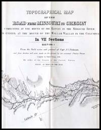
Topographical Map of the Road From Missouri To Oregon Commencing at the Mouth of the Kansas in the Missouri River and Ending at the Mouth of the Wallah Wallah in the Columbia

by Preuss. Charles; Fremont, John Charles

  • Used
  • very good
Condition
Used - Very good
Seller
Chehalis, Washington
Seller rating:
This seller has earned a 2 of 5 Stars rating from Biblio customers.
Item Price
$4,500.00
$5.50 shipping to USA

Show Details

Description:
Washington, 1849. Very good. Lithograph map in seven sections, with each sheet measuring approximately 15.5 x 25 inches. Not bound. Second issue of this monumental and important map of the Oregon Trail, described by Wheat as "a road guide for Oregon emigrants such as had never previously existed." The second issue is nearly identical to the first (which appeared in 1846), but the lithographer's name has been omitted and the numbering of sheets III and VI is reversed. An exceptionally clean set, with no splits or repairs, and almost none of the toning often seen along the folds. Charles Preuss was a Prussian-born surveyor and cartographer who accompanied John C. Fremont on three of his five exploratory expeditions in the American West. His first great map, illustrating Fremont's explorations of 1842 to the Rocky Mountains and of 1843-44 to Oregon and California, was published in 1845. Fremont set off on his third expedition later that year, but Preuss remained behind, using information compiled… Read More
Item Price
$4,500.00
$5.50 shipping to USA
Atlas de l'histoire du Consulat et de l'Empire
More Photos

Atlas de l'histoire du Consulat et de l'Empire

by THIERS, Adolphe

  • Used
  • near fine
  • Hardcover
Condition
Used - Near Fine
Binding
Hardcover
Seller
COLUMBIA, Missouri
Seller rating:
This seller has earned a 5 of 5 Stars rating from Biblio customers.
Item Price
$750.00
FREE shipping to USA

Show Details

Description:
1864 Thiers 66 ATLAS MAPS to Consulate Empire French Revolution Napoleon France
Born during the French Revolution, Adolphe Thiers became a famous French historian, focusing on the history of France and the importance of the French Revolution. He began writing his "History of the French Revolution" in the early 1820s, which would be the foundation for his literary fame and reputation, also providing a boost to his political career.
This ENORMOUS volume is the Atlas tome of Thiers' "History of the Consulate Empire" which includes 66 incredible maps depicting various aspects of the Napoleonic Wars and the French Consulate.
Item number: #16953
Price: $750
THIERS, Adolphe
Atlas de l'histoire du Consulat et de l'Empire
Paris : Lheureux et Cie, 1864.

Details:

· Collation: Complete with all pages
o Illustrated with 66 maps (French titles)
o
Notable topographical maps include:
The English Channel
The Netherlands
Spain and Portugal
Nile River Delta, Egypt
Southern France, Lombardy
·… Read More
Item Price
$750.00
FREE shipping to USA
Historical map of Nantucket, 1869.
More Photos

Historical map of Nantucket, 1869.

by Ferdinand C. Ewer

  • Used
Condition
Used
Seller
Houston, Texas
Seller rating:
This seller has earned a 5 of 5 Stars rating from Biblio customers.
Item Price
$250.00
$9.00 shipping to USA

Show Details

Description:
[Nantucket] [Cape Cod] Ferdinand C. Ewer. Historical map of Nantucket, 1869. [Boston]: [publisher not identified] [Circa 1886-1900] Map 22 x 35 cm. Has been folded. Splits at folds, else very good. OCLC shows ten holdings (Harvard; Salem St.; Univ. Chicago; Boston Public. Lib.; RB Hayes Ctr; Brown Univ.; Dartmouth; Bryn Mawr Col.; Wisc. Hist. Soc. [2]) Surveyed and drawn by the Rev. F.C. Ewer, D.D., 1869. Reduced copy issued by the Old Colony Railroad as an advertisement of its Old Colony Line of steamboats to the Island. Includes historical text. Will frame and display well.
Item Price
$250.00
$9.00 shipping to USA
Collection de cartes concernant les forêts, triages et bois taillés du Comté-prairie d'Eu
More Photos

Collection de cartes concernant les forêts, triages et bois taillés du Comté-prairie d'Eu

by ESTANCELIN, Louis

  • Used
  • near fine
  • Hardcover
  • first
Condition
Used - Near Fine
Edition
First
Binding
Hardcover
Seller
COLUMBIA, Missouri
Seller rating:
This seller has earned a 5 of 5 Stars rating from Biblio customers.
Item Price
$1,500.00
FREE shipping to USA

Show Details

Description:
1768 Forests Eu Normandy France French Agronomy Rivers MAPS Atlas Estancelin

Louis Estancelin, a 19th-century French politician, is best remembered for his book "Collection of Engravings on Forests and Woods in Eu" This work provides descriptions and views of forests, rivers, cities, and harbors in Eu, Normandy and their agronomic and economic implications in in pre-Revolutionary France.
Item number: #19556
Price: $1500
ESTANCELIN, Louis
Collection de cartes concernant les forêts, triages et bois taillés du Comté-prairie d'Eu
1768. 1st edition
Details:

·
Collation:
o
40 (plates)
o
Wanting #2, 3, 29, 32, 34, 35
· Language: French
· Binding: Leather; tight and secure
· Size: ~10.25in X 8.25in (26cm x 21cm)
· Exceedingly rare and desirable with auction records and price comparisons at upwards of $6,000
Our Guarantee:
Very Fast. Very Safe. Free Shipping Worldwide.
Customer satisfaction is our priority! Notify us with 7 days of receiving, and we will offer… Read More
Item Price
$1,500.00
FREE shipping to USA
Map of France - 1842
More Photos

Map of France - 1842

  • Used
Condition
Used
Seller
Cashiers, North Carolina
Seller rating:
This seller has earned a 5 of 5 Stars rating from Biblio customers.
Item Price
$225.00
FREE shipping to USA

Show Details

Description:
1842. "Nouvelle Carte Routiere et Administrative de la FRANCE - toutes les Routes de Poste avec les Distances en Kilometres, Les Chemin de Fer les Canaux de Rivieres navigables ainsi que Les lieux Celebres on Remarquable. Par Charle, Geographe. Paris. Chez Maison, Editeur en France de Richard. Quai des Anonistins, No. 29.1942." Measures 32" x 24". Good condition. Lightly soiled, lines and names unmarked and legible. Some of the panels have separated from backing at bottom edges along fold lines. Slip case is badly worn.
Item Price
$225.00
FREE shipping to USA
RUSSIA IN EUROPE [Original Hand-colored Lithographed Map]
More Photos

RUSSIA IN EUROPE [Original Hand-colored Lithographed Map]

by Mitchell, Samuel Augustus

  • Used
  • very good
Condition
Used - Very Good
Edition
Original
Seller
Williamsburg, Virginia
Seller rating:
This seller has earned a 5 of 5 Stars rating from Biblio customers.
Item Price
$120.00
$6.50 shipping to USA

Show Details

Description:
Philadelphia: Thomas, Cowperthwaite & Co., 1848. This map is from the 1848 edition of A NEW UNIVERSAL ATLAS CONTAINING MAPS OF THE VARIOUS EMPIRES. The atlas was based primarily on the H. S. Tanner UNIVERSAL ATLAS, the rights to which were purchased by Mitchell from Carey & Hart. The early Mitchell maps are distinguished by their vivid hand-coloring and attractive decorated borders. They are among the most sought-after ante-bellum maps published in the United States. This map is guaranteed to be authentic and more than 170 years old. It is in very good condition: clean and bright, with some toning. There is one tiny chip out of one corner of the sheet--far away from the image.. Original. Single Sheet. Very Good. Folio - over 12" - 15" tall. Map.
Item Price
$120.00
$6.50 shipping to USA
Saga of Sydney:  Actor Edward Everett Horton's personal copy)
More Photos

Saga of Sydney: Actor Edward Everett Horton's personal copy)

by Clune, Frank

  • Used
  • very good
  • Hardcover
  • first
Condition
Used - Very Good
Edition
Subscribers Edition
Binding
Hardcover
Seller
Salem, Oregon
Seller rating:
This seller has earned a 5 of 5 Stars rating from Biblio customers.
Item Price
$200.00$120.00
Save $80.00!
$5.00 shipping to USA

Show Details

Description:
Clune, Frank. Saga of Sydney. Sydney Halstead Press, 1961 Subscribers Edition with 118 illustrations and 17 maps. 508 pages. 5 3/4 X 8 3/4. Printed in Australia by Halstead Press, Sydney. Presented to beloved 20th Century American actor Edward Everett Horton at the Australia Hotel, Sydney (1891-1971) by his Australian friend Alexander Rentoul at the hotel March, 1962. Full page hand-written statement on the front end-paper. says: Mr. Horton is best-known for his unforgettable portrayal of Mr. Alexander P. Lovett "Lovey" in the timeless 1937 motion picture "Lost Horizon" directed by Frank Capra. VERY GOOD CONDITION/ NO DJ INCLUDED.
Item Price
$200.00$120.00
Save $80.00 !
$5.00 shipping to USA
Nouveau Voyage aux Isles de l'Amerique, [SIX VOLUME SET] contenant L'Histoire Naturelle...
More Photos

Show Details

Description:
Paris: Chez Theodore la Gras, 1722. First Edition First Printing . Leather Bound. Very Good. 12mo - over 6¾ - 7¾" tall. 12mos. xxxvi, [8], 525; [6], 598; vi, 549; vi, 558; vi, 524; vi, 514, [14] pages. Collates complete with 102 plates and maps, many folding. INCLUDES THE FOLDING MAP OF NORTH AMERICA WITH CALIFORNIA AS AN ISLAND. Hardcovers rebound in mid-20th century full brown leather with titles on the spine in gilt. Light wear to the bindings. New endpapers, but the old endpapers are preserved. Title pages in black and red. Each title page has an inkstamp noting "Case 45 / Shelf B". Occasional tears or chips at the top edges of the pages near the gutter at the front. In Volume I, there is a tear and crease at the fore edge of page 15 and a tear running into the text on the leaf for pages 391-392. Browning to some of the plates in Volume IV. Otherwise the plates are generally in quite good condition. Plates as follows: Vol. I: 3 Maps & Plans… Read More
Item Price
$2,500.00
$3.99 shipping to USA