Click for full-size.
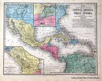
No 16. Map of Mexico, Central America, and the West Indies.
by Mitchell, Samuel Augustus
- Used
- Fine
- first
- Condition
- Fine
- Seller
-
Langley, Washington, United States
Payment Methods Accepted
About This Item
Philadelphia:: Thomas, Cowperthwaite & Co. ,, 1852.. First printing. Fine . Near Fine condition. Original hand-colored lithograph. Folio (11.5" x 9.5"). Light staining.
A finely colored map from early american educator turned atlas producer Samuel Augustus Mitchell (Connecticut 1792-1868). Drawn and engraved by J. H Young.
Includes inset of the Isthmus of Nicaragua showing Proposed Routes from the Caribbean Sea to the Pacific Ocean, and inset of The Isthmus of Tehuantepec showing the Proposed Route from the Gulf of Mexico to the Pacific Ocean.
Matted in ivory rag with french line decoration sized to 18" x 16".
Reviews
(Log in or Create an Account first!)
Details
- Bookseller
- Lowry-James Rare Prints & Books
 (US)
(US)
- Bookseller's Inventory #
- 7176
- Title
- No 16. Map of Mexico, Central America, and the West Indies.
- Author
- Mitchell, Samuel Augustus
- Book Condition
- Used - Fine
- Quantity Available
- 1
- Edition
- First printing
- Publisher
- Thomas, Cowperthwaite & Co. ,
- Place of Publication
- Philadelphia:
- Date Published
- 1852.
- Keywords
- map mexico 1852 mitchell Isthmus Mitchell, S. Augustus Map
Terms of Sale
Lowry-James Rare Prints & Books
We accept Master Card, Visa, American Express, PayPal and Checks. We ship via US Postal Priority, fully insured, with tracking. Insurance over $100 value is additional on all purchases.
About the Seller
Lowry-James Rare Prints & Books
Biblio member since 2006
Langley, Washington
About Lowry-James Rare Prints & Books
Established in 1986, Lowry-James Rare Prints & Books features original engravings and lithographs from the 17th through the 19th Centuries including original work by John James Audubon, early Natural History Prints, Botany and Horticulture, Maps and Cartography.
Glossary
Some terminology that may be used in this description includes:
Frequently asked questions
This Book’s Categories

Collecting P. T. Barnum
P. T. Barnum was not only one of the founders of modern day circus performance, he was also the author of the second most printed book of the 19th century. Learn about collecting P. T. Barnum books and ephemera here.

Learn about Bayntun-Rivière Binders
Are you enchanted by books clad in fine bindings? This is the gallery for you to peruse! Learn more about Bayntun, Rivière & Sons, and their combined work as Bayntun-Rivière.