Description:
Paris: Ganeau, 1744. Excellent condition, strong impression, b&w engraved copperplate from Tome III of the 4to, 1744 edition of Charlevoix's "Histoire de la Nouvelle France" (Journal D'un Voyage...). The image is 9.5 x 14.5 inches, with folds as issued. This image has the full eastern USA, including Louisiane, north to Newfoundland, most of the Great Lakes, teh Atlantic Ocean, Acores, and east to the western coasts of Africa, Spain, France and British Isles. It is quite attractive, and not often seen for sale in this early state..
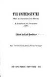
1893 Baedeker's The United States, With An Excursion Into Mexico - : A Handbook for Travelers
Similar copies are shown below.
Similar copies are shown to the right.

1893 Baedeker's The United States, With an Excursion into Mexico: A Handbook for Travelers
- Used
- near fine
- Hardcover
- first
First edition, first printing in English, "with 17 maps and 22 plans" and 22 guide books listed on front pastedown. Collated and complete. Hardcover, in flexible red cloth, gilt-titled on front and spine. Marbled edges, green marker ribbon sewn in. Near fine. Half-inch closed tear at tail of spine, back corner. Else fine, with no markings and almost no wear. A remarkable copy.
-
Bookseller
Independent bookstores
 (US)
(US)
- Format/Binding We should all age this well
- Book Condition Used - Near Fine
- Quantity Available 1
- Binding Hardcover
- Publisher Karl Baedeker / Charles Scribner's Sons
- Place of Publication Leipzig / New York
- Date Published 1893
We have 7 copies available starting at $15.54.

(Map of Eastern America and Atlantic Ocean): Carte De L'Ocean Occidental et Partie De L'Amerique Septentrionale..Charlevoix..fait En 1720
by Bellin, Jacques Nicolas
- Used
- Condition
- Used
- Binding
- Unknown
- Quantity Available
- 1
- Seller
-
Crozet, Virginia, United States
- Item Price
-
$485.00
Show Details
Item Price
$485.00

More Photos
A New and Accurate Description of All the Direct and Principal Cross Roads in England and Wales [bound with] A travelling dictionary: or, alphabetical tables of the distance of all the principal cities, borough, market, and sea-port towns, in Great Britain, from each other. Shewing by Inspection The Number of Miles every City or Town in the Kingdom is Distant from any other, according to the nearest Direct or Cross Road. Comprehending Above Fifty Thousand Distances, carefully collected from the best Authorities, and arranged in a Manner entirely new and plain. To which is Added, A Table, shewing the Distance of the Towns, Bridges, &c. upon the River Thames, from each other by Water. The whole being a second part to the New and accurate description of the roads
by PATERSON, Daniel (1738-1825)
- Used
- Fine
- Condition
- Used - Fine
- Edition
- Early Reprint
- Binding
- Unknown
- Quantity Available
- 1
- Seller
-
Lancaster, Pennsylvania, United States
- Item Price
-
$385.00
Show Details
Description:
London: printed for T. N. Longman, Pater-Noster-Row [from 1771], 1794. Early Reprint. Stiff Wraps. Fine. 8vo: xxxvi,380 numbered columns,381-394pp, with double-page copper-engraved map as frontispiece; [4],216pp. ESTC Citation No. T93564 and T93553. Finely bound to style by Fitterer in stiff beige wraps, printed paper spine label. Binding and text block clean, bright and unmarked save for offsetting from engraved map. A superlative copy. Fordham (Road-Books), pp. 27 and 29. Roscoe, (John Newbery) A399/6. Not in Hodson. The tenth edition: with the addition of near ninety pages, including considerable improvements in the direct roads, many new cross roads, and a great number of noblemen's and gentlemen's seats. Tenth Edition of the first work (1794; originally published 1771) "With the Addition of near Ninety Pages, including considerable Improvements in the direct Roads, many new Cross Roads, and a great Number of Noblemen's and Gentlemen's Seats"; Sixth Edition (1792), improved and corrected, of the…
Read More Item Price
$385.00
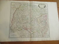
Cercle De Souabe [Original Antique Map from the Atlas Universal of 1757, with Lake Constance, Stuttgart, Augsburg, Etc.]
by Vaugondy, Robert
- Used
- near fine
- Condition
- Used - Near Fine
- Edition
- Original Antique Map
- Binding
- Unknown
- Quantity Available
- 1
- Seller
-
Pasadena, California, United States
- Item Price
-
$400.00
Show Details
Description:
Paris: Robert Vaugondy, 1751. Original Antique Map . Single Sheet. Near Fine. 22" x 32. Original very large antique map, extracted from an atlas. Very detailed, with hundreds of towns and villages, probably all in existence at the time, and showing jurisdictional boundaries as well.
Item Price
$400.00
More Photos
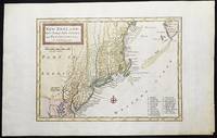
New England, New York, New Jersey, and Pensilvania &c. by H. Moll Geographer
by Moll, Herman
- Used
- near fine
- Condition
- Used - Near Fine
- Binding
- Unknown
- Quantity Available
- 1
- Seller
-
Lansdowne, Pennsylvania, United States
- Item Price
-
$464.00
Show Details
Description:
London: H. Moll, 1708. Near Fine. 1 sheet 232 x 267 mm. (image is 180 x 254 mm.) Hand-colored copper engraved map. This is Herman Moll's earliest map of New England, published in the first edition of John Oldmixon's The British Empire in North America in 1708. List of 19 towns in lower right-hand corner. New Jersey is shown as East New Jersey and West New Jersey. Pennsylvania still contains the Lower Counties, which separated and became Delaware in 1704. On the west side of the Susquehanna River is shown "The Present Sasquahana Indian Fort." In Near Fine Condition: light creasing; clean and bright.
Item Price
$464.00

More Photos
The Albert Nyanza, great basin of the Nile and explorations of the Nile Sources
by BAKER, Samuel White
- Used
- near fine
- Hardcover
- first
- Condition
- Used - Near Fine
- Edition
- first
- Binding
- Hardcover
- Quantity Available
- 1
- Seller
-
COLUMBIA, Missouri, United States
- Item Price
-
$499.00
Show Details
Description:
1866 1edAlbert Nyanza Nile Tributaries AFRICA
Egypt Abyssinia Samuel Baker Maps
Samuel White Baker was an English explorer and was the first Englishman to sit in a high office of the Egyptian government. Many of Baker's works shed light on the horrors of slave owners and slave trade in central Africa. His works, however, also centralized on Egypt and the Abyssinia Nile tributaries. He had an extensive knowledge of Egypt as he held important political officers in Egypt.
His accounts of Egypt and the Nile River Basin are some of the most important 19th-century books on the Nile River and helped record the discovery of Lake Albert. 'The Albert N'yanza, Great Basin of the Nile' is Baker's account of his discovery of the last great source of the Nile.
Item number: #10917
Price: $499
BAKER, Samuel White
The AlbertNyanza, great basin of the Nile and explorations of the Nile Sources
London : Macmillan ; Philadelphia : J.B. Lippincott, 1866. First edition.
Details:
· Collation: Complete with all… Read More
Item Price
$499.00
(Map of Eastern America and Atlantic Ocean): Carte De L'Ocean Occidental et Partie De L'Amerique Septentrionale..Charlevoix..fait En 1720
by Bellin, Jacques Nicolas
- Used
- Condition
- Used
- Binding
- Unknown
- Quantity Available
- 1
- Seller
-
Crozet, Virginia, United States
- Item Price
-
$485.00
Show Details
Description:
Paris: Ganeau, 1744. Excellent condition, strong impression, b&w engraved copperplate from Tome III of the 4to, 1744 edition of Charlevoix's "Histoire de la Nouvelle France" (Journal D'un Voyage...). The image is 9.5 x 14.5 inches, with folds as issued. This image has the full eastern USA, including Louisiane, north to Newfoundland, most of the Great Lakes, teh Atlantic Ocean, Acores, and east to the western coasts of Africa, Spain, France and British Isles. It is quite attractive, and not often seen for sale in this early state..
Item Price
$485.00
More Photos
A New and Accurate Description of All the Direct and Principal Cross Roads in England and Wales [bound with] A travelling dictionary: or, alphabetical tables of the distance of all the principal cities, borough, market, and sea-port towns, in Great Britain, from each other. Shewing by Inspection The Number of Miles every City or Town in the Kingdom is Distant from any other, according to the nearest Direct or Cross Road. Comprehending Above Fifty Thousand Distances, carefully collected from the best Authorities, and arranged in a Manner entirely new and plain. To which is Added, A Table, shewing the Distance of the Towns, Bridges, &c. upon the River Thames, from each other by Water. The whole being a second part to the New and accurate description of the roads
by PATERSON, Daniel (1738-1825)
- Used
- Fine
- Condition
- Used - Fine
- Edition
- Early Reprint
- Binding
- Unknown
- Quantity Available
- 1
- Seller
-
Lancaster, Pennsylvania, United States
- Item Price
-
$385.00
Show Details
Description:
London: printed for T. N. Longman, Pater-Noster-Row [from 1771], 1794. Early Reprint. Stiff Wraps. Fine. 8vo: xxxvi,380 numbered columns,381-394pp, with double-page copper-engraved map as frontispiece; [4],216pp. ESTC Citation No. T93564 and T93553. Finely bound to style by Fitterer in stiff beige wraps, printed paper spine label. Binding and text block clean, bright and unmarked save for offsetting from engraved map. A superlative copy. Fordham (Road-Books), pp. 27 and 29. Roscoe, (John Newbery) A399/6. Not in Hodson. The tenth edition: with the addition of near ninety pages, including considerable improvements in the direct roads, many new cross roads, and a great number of noblemen's and gentlemen's seats. Tenth Edition of the first work (1794; originally published 1771) "With the Addition of near Ninety Pages, including considerable Improvements in the direct Roads, many new Cross Roads, and a great Number of Noblemen's and Gentlemen's Seats"; Sixth Edition (1792), improved and corrected, of the…
Read More Item Price
$385.00
Cercle De Souabe [Original Antique Map from the Atlas Universal of 1757, with Lake Constance, Stuttgart, Augsburg, Etc.]
by Vaugondy, Robert
- Used
- near fine
- Condition
- Used - Near Fine
- Edition
- Original Antique Map
- Binding
- Unknown
- Quantity Available
- 1
- Seller
-
Pasadena, California, United States
- Item Price
-
$400.00
Show Details
Description:
Paris: Robert Vaugondy, 1751. Original Antique Map . Single Sheet. Near Fine. 22" x 32. Original very large antique map, extracted from an atlas. Very detailed, with hundreds of towns and villages, probably all in existence at the time, and showing jurisdictional boundaries as well.
Item Price
$400.00
More Photos
New England, New York, New Jersey, and Pensilvania &c. by H. Moll Geographer
by Moll, Herman
- Used
- near fine
- Condition
- Used - Near Fine
- Binding
- Unknown
- Quantity Available
- 1
- Seller
-
Lansdowne, Pennsylvania, United States
- Item Price
-
$464.00
Show Details
Description:
London: H. Moll, 1708. Near Fine. 1 sheet 232 x 267 mm. (image is 180 x 254 mm.) Hand-colored copper engraved map. This is Herman Moll's earliest map of New England, published in the first edition of John Oldmixon's The British Empire in North America in 1708. List of 19 towns in lower right-hand corner. New Jersey is shown as East New Jersey and West New Jersey. Pennsylvania still contains the Lower Counties, which separated and became Delaware in 1704. On the west side of the Susquehanna River is shown "The Present Sasquahana Indian Fort." In Near Fine Condition: light creasing; clean and bright.
Item Price
$464.00
More Photos
The Albert Nyanza, great basin of the Nile and explorations of the Nile Sources
by BAKER, Samuel White
- Used
- near fine
- Hardcover
- first
- Condition
- Used - Near Fine
- Edition
- first
- Binding
- Hardcover
- Quantity Available
- 1
- Seller
-
COLUMBIA, Missouri, United States
- Item Price
-
$499.00
Show Details
Description:
1866 1edAlbert Nyanza Nile Tributaries AFRICA
Egypt Abyssinia Samuel Baker Maps
Samuel White Baker was an English explorer and was the first Englishman to sit in a high office of the Egyptian government. Many of Baker's works shed light on the horrors of slave owners and slave trade in central Africa. His works, however, also centralized on Egypt and the Abyssinia Nile tributaries. He had an extensive knowledge of Egypt as he held important political officers in Egypt.
His accounts of Egypt and the Nile River Basin are some of the most important 19th-century books on the Nile River and helped record the discovery of Lake Albert. 'The Albert N'yanza, Great Basin of the Nile' is Baker's account of his discovery of the last great source of the Nile.
Item number: #10917
Price: $499
BAKER, Samuel White
The AlbertNyanza, great basin of the Nile and explorations of the Nile Sources
London : Macmillan ; Philadelphia : J.B. Lippincott, 1866. First edition.
Details:
· Collation: Complete with all… Read More
Item Price
$499.00
Stock Photo: Cover May Be Different
Baedeker's The United States, With an Excursion into Mexico: A Handbook for Travelers, 1893
by Editor-Karl Baedeker; Introduction-Henry Steele Commager
- Used
- good
- Hardcover
- Condition
- Used - Good
- Binding
- Hardcover
- ISBN 13
- 9780306713415
- ISBN 10
- 0306713411
- Quantity Available
- 1
- Seller
-
HOUSTON, Texas, United States
- Item Price
-
$15.54
Show Details
Description:
Dacapo Pr Remainders, 1971. Hardcover. Good.
Item Price
$15.54
Stock Photo: Cover May Be Different
Baedeker's The United States, With an Excursion into Mexico: A Handbook for Travelers, 1893
by Karl Baedeker
- Used
- Fine
- Paperback
- first
- Condition
- Used - Fine
- Jacket Condition
- Very Good
- Binding
- Paperback
- ISBN 13
- 9780306713415
- ISBN 10
- 0306713411
- Quantity Available
- 1
- Seller
-
Lancaster, Pennsylvania, United States
- Item Price
-
$13.00
Show Details
Description:
New York: Dacapo Press, 1971. Soft cover. Fine/Very Good. An unabridged reproduction of the first American Baedeker published in Leipzig and New York in 1893. Gilt lettering on blue covers in a tan & orange dust jacket. 8vo, 516pp. Dust jacket spine top edge chipped.
Item Price
$13.00
Stock Photo: Cover May Be Different
Baedeker's the United States, with an Excursion Into Mexico A Handbook for Travelers, 1893
by Baedeker, Karl; Henry Steele Commager (Intro. )
- Used
- Hardcover
- Condition
- Used - Very Good+ in Very Good dust jacket
- Binding
- Hardcover
- ISBN 13
- 9780306713415
- ISBN 10
- 0306713411
- Quantity Available
- 1
- Seller
-
Lancaster, Pennsylvania, United States
- Item Price
-
$17.50
Show Details
Description:
New York: Da Capo Press. Very Good+ in Very Good dust jacket. 1971. Hardcover. 0306713411 . Color maps; Large 8vo 9" - 10" tall; 516 pages; 1971 Da Capo Press. Stout HC/DJ. A solid reprinting of the scarce 1st Baedecker treatment of the United States. Illustrated throughout with color reproductons of the original region and city maps. Jacket a little toned and slightly rubbed at edges; front flap corners clipped. VG++/VG .
Item Price
$17.50
Stock Photo: Cover May Be Different
Baedeker's the United States, with an Excursion Into Mexico A Handbook for Travelers, 1893
by Baedeker, Karl
- Used
- Hardcover
- Condition
- Used - Good in Good dust jacket
- Binding
- Hardcover
- ISBN 13
- 9780306713415
- ISBN 10
- 0306713411
- Quantity Available
- 1
- Seller
-
HOUSTON, Texas, United States
- Item Price
-
$22.00
Show Details
Description:
Dacapo Press. Good in Good dust jacket. 1971. Hardcover. 0306713411 . Xlib; Ex-Library; 8.6 X 5.5 X 1.8 inches; 516 pages .
Item Price
$22.00

Baedeker's The United States, with an Excursion into Mexico: A Handbook for Travelers, 1893
by BAEDEKER, Karl (ed)
- Used
- Condition
- Used
- Quantity Available
- 1
- Seller
-
Norwich, Vermont, United States
- Item Price
-
$40.00
Show Details
Description:
Da Capo Press, 1971. Hbk, 516pp, illustr maps in color and b+w, including fold-outs, dj slightly sunned at spine, otherwise fine, unclipped and nor in protective sleeve, otherwise an unread copy, excellent clean tight unmarked, as new
Item Price
$40.00
Stock Photo: Cover May Be Different
Baedeker's The United States, With an Excursion into Mexico: A Handbook for Travelers, 1893
by Karl Baedeker
- Used
- Fine
- Hardcover
- Condition
- Used - Fine
- Jacket Condition
- Near Fine
- Binding
- Hardcover
- ISBN 13
- 9780306713415
- ISBN 10
- 0306713411
- Quantity Available
- 1
- Seller
-
Garrison, New York, United States
- Item Price
-
$60.00
Show Details
Description:
Dacapo Press. DJ in archival cover price clipped. . Fine. Hardcover. 1971.
Item Price
$60.00
Stock Photo: Cover May Be Different
Baedeker's The United States, With an Excursion into Mexico: A Handbook for Travelers, 1893
by Karl Baedeker [Editor]; Henry Steele Commager [Introduction];
- New
- Paperback
- Condition
- New
- Binding
- Paperback
- ISBN 13
- 9780306713415
- ISBN 10
- 0306713411
- Quantity Available
- 1
- Seller
-
San Diego, California, United States
- Item Price
-
$69.13
Show Details
Description:
Dacapo Press, 1971-01-01. Paperback. New. New. In shrink wrap. Looks like an interesting title!
Item Price
$69.13

More Photos
The Sky and the Forest
by Forester, C.S
- Used
- very good
- Hardcover
- first
- Condition
- Used - Very Good
- Jacket Condition
- Very Good
- Edition
- First Edition
- Binding
- Hardcover
- Quantity Available
- 1
- Seller
-
Salem, Oregon, United States
- Item Price
-
$40.00$24.00Save $16.00!
Show Details
Description:
C.S. Forester: The Sky and the Forest. Little, Brown and Company, Boston. Stated First Edition First Printing Thus August, 1948. Cover price $2.75. Used. VG BOOK/VG UNCLIPPED DUST JACKET. A story of a central Africa. By C.S. Forester, author of the Admiral Hornblower series.
Item Price
$40.00$24.00
Save $16.00
!
![Alaska and Klondike Region; [With inset of Klondike Region on the Upper Yukon detail] [From an...](https://d3525k1ryd2155.cloudfront.net/h/062/537/1339537062.0.m.jpg)
Alaska and Klondike Region; [With inset of Klondike Region on the Upper Yukon detail] [From an atlas, "Gazetteer of Alaska and Yukon Region " pp. 105 and 106]
by Miller, J. Martin
- Used
- very good
- Condition
- Used - Very Good
- Edition
- Unknown
- Quantity Available
- 1
- Seller
-
Sebastopol, California, United States
- Item Price
-
$39.00
Show Details
Description:
Chicago: J. Martin Miller, 1899. Unknown. Map. Very Good. [Map copyright 1899, printing date of Atlas later] [19.875x15.125in]; Colored map of Alaska with steamer routes from Portland and Seattle, insets of the Klondike Region on the Upper Yukon and Western portion of Aleutian Islands; On verso index of places and names with two large black and white images; Age toning to all edges, water stain marks on bottom, slight printing offset of colors, small chips and closed tears to lower edge;.
Item Price
$39.00

Zemepis Sveta - Monsunova Asie
by De La Blache, P. Vidal; Gallois, L
- Used
- Hardcover
- Condition
- Used - Very Good Condition
- Jacket Condition
- No Dust Jacket
- Binding
- Hardcover
- Quantity Available
- 1
- Seller
-
Oak Point, Texas, United States
- Item Price
-
$60.00
Show Details
Description:
Aventinum, Prague, Czechoslovakia, 1931. Hardcover. Very Good Condition/No Dust Jacket. Text entirely in Czech. Geography book on Asia with numerous photographs and maps. 1930 edition also available. Size: 4mo - over 9 3/4" - 12" tall. 400 pp. Pages are yellowed, but are tight and clean. Moderate shelfwear along the spine. Corners are lightly bumped. Quantity Available: 1. Shipped Weight: 3-5 pounds. Category: Travel & Places; Non-English Language::Czech; Pictures of this item not already displayed here available upon request. Inventory No: 001228. . Additional shipping charges may apply.
Item Price
$60.00

Zemepis Sveta - Monsunova Asie
by De La Blache, P. Vidal; Gallois, L
- Used
- Hardcover
- Condition
- Used - Very Good Condition
- Jacket Condition
- No Dust Jacket
- Binding
- Hardcover
- Quantity Available
- 1
- Seller
-
Oak Point, Texas, United States
- Item Price
-
$60.00
Show Details
Description:
Aventinum, Prague, Czechoslovakia, 1930. Hardcover. Very Good Condition/No Dust Jacket. Text entirely in Czech. Geography book on Asia with numerous photographs and maps. 1931 edition also available. Size: 4mo - over 9 3/4" - 12" tall. 400 pp. Pages are yellowed, but are tight and clean. Moderate shelfwear along the spine. Corners are lightly bumped. Quantity Available: 1. Shipped Weight: 3-5 pounds. Category: Travel & Places; Non-English Language::Czech; Pictures of this item not already displayed here available upon request. Inventory No: 001227. . Additional shipping charges may apply.
Item Price
$60.00

North America from the Best Authorities, Russell, ca.1800
by Russell
- Used
- Condition
- Used
- Quantity Available
- 1
- Seller
-
Plymouth, Devon, United Kingdom
- Item Price
-
$25.27
Show Details
Description:
Russell, J. : A General Map of North America from the Best Authorities. Nd but ca.1800. From "A New Geographical, Historical and Commercial Grammar and Present State of Several Kingdoms of the World." Copper engraving. Size approx 200 x 230mm. Two neat folds. Some age colouring to edges, otherwise very clean and bright.
Item Price
$25.27

Asia from the Best Authorities, Russell, ca.1800
by Russell
- Used
- Condition
- Used
- Quantity Available
- 1
- Seller
-
Plymouth, Devon, United Kingdom
- Item Price
-
$25.27
Show Details
Description:
Russell, J. : Asia from the Best Authorities. Nd but ca.1800. From "A New Geographical, Historical and Commercial Grammar and Present State of Several Kingdoms of the World". Copper engraving. Size approx 200 x 230mm. Two neat folds. Some age colouring to edges, otherwise clean and bright. Includes Arabia, India, Borneo, Japan, China and eastern Russia.
Item Price
$25.27
![MAP OF UTAH [Territory]](https://d3525k1ryd2155.cloudfront.net/h/836/461/1485461836.0.m.jpg)
More Photos
MAP OF UTAH [Territory]
- Used
- Condition
- Used - Very Good-
- Edition
- Original
- Quantity Available
- 1
- Seller
-
Williamsburg, Virginia, United States
- Item Price
-
$65.00
Show Details
Description:
New York, Richmond, Chicago, & Toledo: H. H. Hardesty, 1885. Original color lithographed map printed by Rand, McNally & Company, Engravers and published in HARDESTY'S HISTORICAL AND GEOGRAPHICAL ENCYCLOPEDIA: SPECIAL VIRGINIA EDITION. 19 3/8 inches by 13 1/4 inches on a 21" X 14 1/2" sheet. The map depicts the Territory of Utah in its final form--large areas had been removed and ceded to Nevada, Colorado, Wyoming, and Nebraska since Utah became a U. S. Territory in 1850. The issue of polygamy prevented statehood until it was finally granted in 1896. This map features railroads and topography and uses color to set off counties from each other. Unlike most atlas maps of the period, this map identifies most small towns. The map is guaranteed to be moe than 135 years old. The map is in about very good condition: generally clean and bright, with slight toning of paper and one faint water stain near the center-left edge of the map.. Original. Single Sheet. Very Good-. Elephant…
Read More Item Price
$65.00

Last Tales
by Dinesen, Isak
- Used
- very good
- Hardcover
- first
- Condition
- Used - Very Good
- Jacket Condition
- Good+
- Edition
- First Edition
- Binding
- Hardcover
- Quantity Available
- 1
- Seller
-
Salem, Oregon, United States
- Item Price
-
$120.00$72.00Save $48.00!
Show Details
Description:
Dinesen, Isak: Last Tales, A Collection of Twelve New Tales of Compelling Beauty 1957, Random House. First Edition. Stated First Printing Thus. Used. Very Good/Good+ original red dust jacket, price-clipped. Jacket states 11/57 on front flap. 5 3/4 X
Item Price
$120.00$72.00
Save $48.00
!

Philips Special Map of the Nile, The Advance on Khartum and the Environs of Omdurman. Cc1900
by George Philips and Son,
- Used
- Condition
- Used
- Quantity Available
- 1
- Seller
-
Plymouth, Devon, United Kingdom
- Item Price
-
$32.85
Show Details
Description:
Philips Special map of the Nile illustrating the Advance on Khartum [Khartoum] with an enlargement of the environs of Omdurman [Omdur]. George Philips and Son, London and Liverpool Ca 1900. 580mm x 900mm folded map. Front title wrapper has come loose, not affecting map area. Three maps are displayed within the sheet. Map1. Map of the Nile Valley 520mm x 300mm showing the approaches of Khartum. Scale 1inch to 100 Geographical miles. Coloured indicating Possessions and Protectorates of European Powers. Map 2. Special map of the Nile from Dongola to Khartum. Scale 16 miles to the inch. Coloured. In set in this map is Map3. Environs of Omdurman, Scale 5 statute miles to the inch. Some small breaks at some folds, not affecting imagery or use of map. Title label is damaged, the map is clean and bright, probably unused. A very interesting record.
Item Price
$32.85

Seven Pillars Of Wisdom, A Triumph
by Lawrence, T.E
- Used
- good
- Hardcover
- first
- Condition
- Used - Good
- Jacket Condition
- No DJ Included
- Edition
- First American Edition
- Binding
- Hardcover
- Quantity Available
- 1
- Seller
-
Salem, Oregon, United States
- Item Price
-
$124.95$74.97Save $49.98!
Show Details
Description:
T.E. Lawrence. SEVEN PILLARS OF WISDOM, A TRIUMPH. AUTOBIOGRAPHY. Privately Printed, 1926. First Published for general circulation 1935. First American Edition. States MCMXXXVI on the title page. Doubleday, Doran & Company, Inc. Garden City, NY. GOOD CONDITION/ NO DUST JACKET IS INCLUDED. 672 pages, indexed. Beige buckram boards. Spine has darkened a bit. 6 7/8 X 9 ½.
Item Price
$124.95$74.97
Save $49.98
!