Click for full-size.


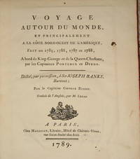
(22 maps & plates- Canada, Northwest American Coast Exploration): Voyage Autour Du Monde..A La Cote Nord-Ouest De L'Amerique..1785, 1786, 1787, 1788..Par Le Capitaines Portlock et Dixon
by Dixon, Capitaines George (dedicated to Sir Joseph Banks)
- Used
- very good
- Hardcover
- first
- Condition
- Very Good
- Seller
-
Crozet, Virginia, United States
Payment Methods Accepted
About This Item
Paris: Maradan, 1789. Small 4to (10 inches); first French edition (there was a smaller and later 8vo. edition in 2 volumes). Contemporary vellum spine separated at front edge (boards attached and binding sound), with somewhat later boards and endpapers, with red gilt-lettered label intact though a bit scuffed and slightly chipped at the right lower edge. Boards a bit scuffed at edges; binding tight, interior very good or better with all 22 engraved plates (numbered 1-21, plus the large folding frontis map (color coded for voyage routes and titled "Carte des Voyages du King George et de la Reine Charlotte...). This is 499 pp, including appendix I, plus appendix II of 46pp, followed by the 2 pp Approbation. One of the plates is of a Native American, plus there are several maps and views, along with the later engravings of several birds (very attractive). This is an increasingly uncommon and very nice copy of this detailed explorations of the Pacific Northwest and Queen Charlotte Islands, with all the maps and plates in excellent condition. Howes D365; Sabin 20366.. First Edition Thus. Very Good. 4to - over 9¾" - 12" tall.
Reviews
(Log in or Create an Account first!)
Details
- Bookseller
- The Prime Meridian: Antique Maps & Books
 (US)
(US)
- Bookseller's Inventory #
- 3082
- Title
- (22 maps & plates- Canada, Northwest American Coast Exploration): Voyage Autour Du Monde..A La Cote Nord-Ouest De L'Amerique..1785, 1786, 1787, 1788..Par Le Capitaines Portlock et Dixon
- Author
- Dixon, Capitaines George (dedicated to Sir Joseph Banks)
- Book Condition
- Used - Very Good
- Edition
- First Edition Thus
- Binding
- Hardcover
- Publisher
- Maradan
- Place of Publication
- Paris
- Date Published
- 1789
- Keywords
- Fr, Maps, Mapping, Cartography, Geography, American, Pacific Northwest, Nathaniel Portlock, Travel, Exploration, Atlases,
- Bookseller catalogs
- H. Books--Travel & Exploration; E. Books--Atlases;
- Note
- May be a multi-volume set and require additional postage.
Terms of Sale
The Prime Meridian: Antique Maps & Books
We accept cash, check, money order, American Express, Visa, Discover and Mastercard. Virginia sales tax will be added to instate purchases. Shipping charges are billed at cost, and will be added to the invoice. We usually include insurance with the postage, and as a result we do not routinely use media mail. If you wish the book sent via the latter route, it would be at your risk. For heavy items, there may be extra shipping charges. Any item maybe returned (postpaid and carefully packed by purchaser) within 7 days of receipt. We do not generally refund postal charges. Please notify us before sending a return. We do not share customer information with any outside sources; all details and addresses are confidential.
About the Seller
The Prime Meridian: Antique Maps & Books
Biblio member since 2005
Crozet, Virginia
About The Prime Meridian: Antique Maps & Books
The Prime Meridian: Antique Maps & Books is owned and operated by Joel & Deborah Kovarsky. We first opened in 1998, but have had a decades-old interest in old maps, books, and paper, stemming from a comparable long-standing interest in how knowledge is used. Our business is run via the internet. We do not run an open shop, however we do welcome visitors by appointment only. Before attempting a visit, please contact us. We are a specialty business, dealing in antiquarian maps and related books (atlases, history of cartography, selected reference books, etc.). Please feel free to contact us for specific inquiries.
Glossary
Some terminology that may be used in this description includes:
- First Edition
- In book collecting, the first edition is the earliest published form of a book. A book may have more than one first edition in...
- Tight
- Used to mean that the binding of a book has not been overly loosened by frequent use.
- Spine
- The outer portion of a book which covers the actual binding. The spine usually faces outward when a book is placed on a shelf....
- Vellum
- Vellum is a sheet of specialty prepared skin of lamb, calf, or goat kid used for binding a book or for printing and writing. ...
Frequently asked questions

Collecting The Beat Generation
The Beat Generation was born out of WWII, and it still continues to exert considerable influence on today’s literary scene. Biblio sellers have a fantastic collection of Beat Generation books and ephemera for browsing.

Beat Poet Michael McClure
From the fateful reading at Six-Gallery in 1955 to his novels, poetry, and stage productions, Michael McClure was right in the thick of the Beat Generation as it was born. See his books and art and learn more about the works of Michael McClure.