Description:
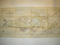
Borough of Hopatcong, New Jersey?, 1912. Near Fine condition. SEE PHOTO. This is a beautiful and very scarce color map of Lake Hopatcong, New Jersey. When unfolded it measures 18" tall by 38" wide. Some folds have been neatly reinforced on the blank side with archival-quality document repair tape. Buildings are represented by red squares, water in green. Some of the properties and locations depicted are: Port Morris, Landing, Roxbury Township, Borough of Mount Arlington, Byram Township, Nolans Point, Atlas Powder Co., Brookland, Borough of Hopatcong, Byram Cove, Henderson Bay, Byram Bay, Maxim Park, Jefferson Township, Woodport, Hurdtown, Hurd Mining Co., W. M. Force Estate, John P. Lawless, Mary Ingram estate, Aaron Peck estate, Raccoon Island, Halsey Island, Bertrand Island, Theodore King, Gertrude Otten, Violet Littell, Robert Dunlap estate, etc. Full title: "Property Map of Lake Hopatcong, New Jersey, Prepared by Hudson Maxim for the Morris Canal Investigation Commission,…
Read More Atlas of the City of Philadelphia (Wards 24, 27, 24. 40, 44 & 46) West Philadelphia by Bromley, George W.; Bromley, Walter S - 1927
by Bromley, George W.; Bromley, Walter S

Atlas of the City of Philadelphia (Wards 24, 27, 24. 40, 44 & 46) West Philadelphia
by Bromley, George W.; Bromley, Walter S
- Used
- good
- Hardcover
G. W. Bromley & Co., 1927. Hardcover bound in black leather along the spine and at the corners with title in gilt along the spine and on an applied label on the front, grey cloth covered boards, illustrated with colored maps with 43 thumb tags marking each map. The maps were made from actual surveys and official plans. All pages are lined backed. Book is worn along the spine with most of the title there obliterated, some scratches on the corners with a few spots of wear along the edges, cover fabric is lightly soiled, front free end paper has a repaired tear that runs most of its width. Text is unmarked but the paper is age toned with a little soiling. Images available. USPS confirmation used on all domestic shipments. Over-sized copy will need additional postage will be necessary for Priority or International addresses. No Edition Stated. Half-Leather. Good/ . Map.
-
Bookseller
The Bookbums at Ish Kabibble Books
 (US)
(US)
- Format/Binding Hardcover
- Book Condition Used - Good
- Jacket Condition
- Edition No Edition Stated
- Binding Hardcover
- Publisher G. W. Bromley & Co.
- Date Published 1927
- Keywords MAPS | ATLAS | PHILADELPHIA
Property Map of Lake Hopatcong, New Jersey, Prepared by Hudson Maxim for the Morris Canal Investigation Commission, November 16, 1912, Compiled from Various Maps and Actual Surveys by P. E. Boomer, C. E.
by Maxim, Hudson; & P. E. Boomer
- Used
- Paperback
- first
- Condition
- Used - Near Fine condition
- Edition
- First Edition
- Binding
- Paperback
- Quantity Available
- 1
- Seller
-
Henderson, Nevada, United States
- Item Price
-
$1,495.00
Show Details
Item Price
$1,495.00

The island of Crete and the adjacent islands of the Aegean with the new island of Santorini ... "Insuls Creta nunc Candia in sua IV Territoria distinicta, cum aliqoud adjacentibus Ægei maris Insulis imprimis Nova Santorini insula modo ante XXVII annos ex abysso marsi emersa..." "Creta nunc Candia
by Lotter Conrad Tobias
- Used
- Condition
- Used
- Binding
- Unknown
- Quantity Available
- 1
- Seller
-
Nafplion, Greece
- Item Price
-
$1,628.40
Show Details
Description:
Greece: Augsburg, Lotter Conrad Tobias 1772. Copper engraved map of Crete with View of Iraklion after Seutter from Lotters "Atlas Novus." . Original old colour; verso blank The map shows the island of Crete, taken from the Homann map of 1712 [ Zacharakis 1641/1879] with the a long text beside the newly emerged island at Santorini following the volcanic eruption of 25th May 1707: "In 1707, activity began again, the small when two cones appeared. They were called Aspronisi and Macronesi. Those were united in the course of the following five years by an island which formed between Palea and Small Kameni, much larger and higher then either and was called Nea (New) Kameni .This island, is the youngest island in Greece."[Santorini Living ] Below is a panaromic view of Iraklion, black & white as issued. The map was first published by Lotter's father-in-law Matthaüs Seutter in his "Atlas Novus" in 1728 who took the lower part of Homann's map re-engraved the cartouche and text and added the scale to the…
Read More Item Price
$1,628.40

More Photos
Where Stucco Meets Chaparrel.
by [Pie in the Sky Press] Rebecca Chamlee.
- Used
- Hardcover
- Signed
- Condition
- Used
- Edition
- Edition of 60 + 26 lettered copies
- Binding
- Hardcover
- Quantity Available
- 1
- Seller
-
Hoover, Alabama, United States
- Item Price
-
$1,250.00
Show Details
Description:
[Simi Valley, California]:: Pie in the Sky Press,, 2014.. Edition of 60 + 26 lettered copies. Of the edition there are three states: Deluxe (Lettered copies); Standard (numbered 1-25); and Special (Numbered 26-60). Printed letterpress. Handset California Old Style cast by M & H Typefounders and Gothic XX Condensed wood type. Printed using photopolymer plates and hand-carved Gomuban relief plates. Signed by the artist on the colophon.
Standard: 6 x 9"; 108 pages. Printed on Somerset papers. Bound in simplified style with printed abaca wrapped boards and a cloth spine. Numbered. Rebecca Chamlee, prospectus: "Like the self-taught naturalists of the Victorian era, my recent work examines the intersection of my artistic and scientific interests by collecting and cataloging the natural world. I am inspired to record, interpret, and celebrate nature.
"In my new artist's book I observe the natural world around me. Where Stucco Meets Chaparral explores the trails through…
Read More Item Price
$1,250.00

More Photos
富士見十三州輿地全圖. [Fujimi Jūsanshū yochi zenzu]. [Map of the Thirteen Provinces From Where Mt. Fuji Is Visible].
by AKIYAMA EINEN [OR NAGATOSHI] 秋山永年.
- Used
- Condition
- Used
- Edition
- [Reprint].
- Binding
- Unknown
- Quantity Available
- 1
- Seller
-
Canberra, Australian Capital Territory, Australia
- Item Price
-
$1,653.50
Show Details
Description:
Shūseidō 衆星堂. [Reprint].. Tenpō 14 (1843).. Large folding handcoloured map of the thirteen provinces from which Mt. Fuji can be viewed. 159 x 178cm. Folds into paper covered card covers measuring 40 x 24cm. Title label upper cover. A little browning along folds, occasional spotting and soiling. A little worming causing approximately 1cm of loss in places. Two chops in lower section. A very striking and attractive map. This very large handsome map is a detailed map of the thirteen provinces from which one can see Mt. Fuji. Provinces shown are the eight provinces of the Kantō region, Sagami 相模, Musashi 武蔵, Kazusa 上総, Shimofusa 下総, Awa 安房, Kōzuke 上野, Shimotsuke 下野, and Hitachi, 常陸, and five other provinces, Izu 伊豆, Suruga 駿河, Tōtōmi 遠江, Kai 甲斐, and Shinano 信濃. The map…
Read More Item Price
$1,653.50

More Photos
ATLAS OF CATTARAUGUS COUNTY, NEW YORK : FROM ACTUAL SURVEYS AND OFFICIAL RECORDS
by D. G. Beers & Co , compiler
- Used
- very good
- Hardcover
- first
- Condition
- Used - Very Good
- Edition
- First Edition
- Binding
- Hardcover
- Quantity Available
- 1
- Seller
-
Fairfield, New Jersey, United States
- Item Price
-
$1,200.00
Show Details
Description:
New York: D. G. Beers & Co, A. D. Ellis & G. G. Soule. Very Good. 1869. First Edition. Hardcover. Original 1869 brown marbled boards over brown cloth spine. Contain 41 color maps including 4 that are double page. Each is appox. 12" 15". THE MAPS ARE IN VG TO NEAR FINE CONDITION. Occasional light soil on a margin. Atlas is graded G+ due to several tears along spine & rubbed cover edges & corners. Binding is tight. New York Atlas.. ; Folio 13" - 23" tall; 98 pages .
Item Price
$1,200.00
![[World Map, Bible]: A Map of all the Earth and how after the Flood it was divided among the Sons...](https://d3525k1ryd2155.cloudfront.net/h/880/450/438450880.0.m.jpg)
[World Map, Bible]: A Map of all the Earth and how after the Flood it was divided among the Sons of Noah
by Moxon, Joseph
- Used
- first
- Condition
- Used
- Binding
- Unknown
- Quantity Available
- 1
- Seller
-
Crozet, Virginia, United States
- Item Price
-
$1,975.00
Show Details
Description:
Amsterdam: Visscher, Nicholas (Nicolaus), 1685. Very good, early color (perhaps some recent enhancement), few tiny worm holes, minor restoration at lower right (no image loss) and flattened center fold. Minmial browning margins. The date is approximate. Numerous biblical vignettes, some with Hebrew lettering. This was done for a Dutch bible, this one published by Visscher in Amsterday. Shirley's entry 457 is a similar map but without the Visscher imprint (and this issue does not have the tabular information in the lower central area. North America is labeled with "Japhet," and "Eden" is shown towards the cetner of the depiction of Asia. The vignettes are quite decorative. Moxon was a print and globe-maker, and he was the first tradesman to be elected to the Royal Society (online Dictionary of National Biography). The image measures 32 x 46 cm (18 x 12.5 inches), and has good margins..
Item Price
$1,975.00
America Novita Delineator
by Merian, Matthaus
- Used
- Condition
- Used
- Quantity Available
- 1
- Seller
-
Florham Park, New Jersey, United States
- Item Price
-
$1,650.00
Show Details
Description:
Engraved map, 35.6 x 28 cm (11" x 14"), uncolored. Faint soiling, repair of centerfold with archival tape; near fine with crisp impression. Mathhaus Merian (1593-1650) was a well known engraver that would run a publishing house in Frankfurt. This very attractive map of the Americas is based on maps by Blaeu and Hondius (see Tooley & Goss). Part of the charm of this map is the somewhat primitive arrangement of the subject. North America is shown with a prominent Virginia, but with an odd New England coastline. Florida is basically a stub, and the western coastline above California makes the continent look too wide. The Great Lakes have little presence, but the map does feature a large island lake in equatorial South America. The map also includes an inset of Greenland, and you can actually see part of Europe. A rather plan title cartouche, a sea monster and Spanish Galleons decorate the map. Merian's engraved signature can be seen in the lower right. Tooley: The Mapping of America (p.299). Goss:…
Read More Item Price
$1,650.00

More Photos
Chios. "Chios Maris Aegæ ieiusdem nominis Insulae Civitas
by Braun & Hogenberg
- Used
- Condition
- Used
- Binding
- Unknown
- Quantity Available
- 1
- Seller
-
Nafplion, Greece
- Item Price
-
$1,302.72
Show Details
Description:
Greece: Cologne G von Kempen 1588. Copper engraved view of Chios from the fourth volume of Braun & Hogenberg's "Civitas Orbis Terrarum. " Latin text to verso; black & white as issued. The engraving shows the port and capital of Chios, seen from the east in a bird's-eye view. The town is represented as divided into the strongly fortified Byzantine Kastro and the town itself, which is defended on the landward side by massive watchtowers with a moat and a drawbridge. Windmills line the coast; A canon fire s out to sea from a tower on the sea wall; numerous ships and galleys. Decorative title cartouche The city is often locally referred to as "Chora" (Χώρα; literally meaning "town") or "Kastro" (Κάστρο) to distinguish it from the entirety of the island with which it shares the name. Originally the site of an ancient settlement, the town was first built at the north side of a natural harbour. By the 16th century, the walled town had been further fortified by successive rulers into a massive…
Read More Item Price
$1,302.72

More Photos
Travels in the Interior Districts of Africa: Performed under the direction and patronage of the african association, in the years 1795, 1796, and 1797. with an appendix, containing illustrations of Africa by Major Rennel
by PARK, Mungo
- Used
- very good
- Hardcover
- Condition
- Used - Very Good
- Edition
- 2nd
- Binding
- Hardcover
- Quantity Available
- 1
- Seller
-
Cuernavaca, Mexico
- Item Price
-
$1,590.00
Show Details
Description:
London, W.Bulmer and Co., 17994º. xxviii,(2),372 pp., xcii. Bound to style in a fine later calf. Title-and tomelabels with gilt lettering. Blindtoolings to bands and compartments of spine. Engraved portrait as frontispiece, 2 engraved plates with music, 5 engraved plates (of which 3 are views) and 3 large folded engraved maps. One map strenghtened in foldings and edges, one map with a closed tear to folding. Wide-margined, a few margins slightly brownspotted. Light offsetting to title and portrait.
Second edition - the same year as the first - of this classic work of travel litterature.
"Until the publicationof Park's book in 1799 hardly anything was known of the interior of Africa, apart from the north-east region and coastal areas....the real opening up of Africa by the white races began with the African Association, founded in 1788 with the express purpose of exploring Africa and furthering British tradee and political influence onthe continent...Parks travels had an immediate success and was… Read More
Item Price
$1,590.00
More Photos
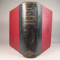
The Discovery of North America, A Critical, Documentary, and Historic Investigation,: with an essay on the early cartography of the New World, including descriptions of two hundred and fifty maps or globes existing or lost, constructed before the year 1536...
by Henry Harrisse
- Used
- very good
- Hardcover
- first
- Condition
- Used - Very Good
- Edition
- First Edition
- Binding
- Hardcover
- Quantity Available
- 1
- Seller
-
Fort Lauderdale, Florida, United States
- Item Price
-
$1,450.00
Show Details
Description:
Quarter morocco over pictorial maroon cloth board with gilt particulars to spine. Top edge gilt. Limited edition copy No. 91 of 380 issued, this being the English Toned Paper edition. Hors textes plates with tissue guards throughout. Black and white illustrations throughout text as well. Title continued: "to which are added a chronology of one hundred voyages westward, projected, attempted, or accomplished between 1431 and 1504; biographical accounts of the three hundred pilots who first crossed the Atlantic; and a copious list of the original names of American regions, caciqueships, mountains, islands, capes, gulfs, rivers, towns, and harbours." Topics include: John Cabot, Gaspar Corte-Real, Christopher Columbus, Ancient Maps, First Knowledge of Florida, Colonisation [colonization] of Nova Scotia, Aliminos, Pardon Real, Lusitano-Germanic Cartography, and much more. Wear to head of spine and hinges, but still intact and sturdy. 802 pp. 9 3/4 x 11 3/4. A clean, bright volume without previous owners'…
Read More Item Price
$1,450.00
![Plate 163, Part of Section 8 [Washington Heights]](https://d3525k1ryd2155.cloudfront.net/h/006/936/1407936006.0.m.jpg)
Plate 163, Part of Section 8 [Washington Heights]
by BROMLEY, George W. and BROMLEY, Walter S
- Used
- Condition
- Used
- Quantity Available
- 1
- Seller
-
New York, New York, United States
- Item Price
-
$125.00
Show Details
Description:
Philadelphia: G.W. Bromley, 1925. Map. Original Lithograph. 11 1/4" x 16 1/4"<br/> <br/> This ward map of Manhattan shows the area from W. 157th Street to W 163nd Street, Riverside Drive to Broadway. On the verso, it depicts from Broadway to Amsterdam. Notably, a wooden structure is visible on Riverside Drive between 160th and 158th Streets. This structure, 857 Riverside Dr., was built in 1851, possibly by John Woodhouse Audubon, son of the famous naturalist. The property was owned by sugar refiner and abolitionist minister Dennis Harris from 1852 to 1854. It was then occupied by Harris' friend and fellow abolitionist Judge John Newhouse and his family through the end of the 19th century, and is believed to have had ties to the Underground Railroad. The house is currently at risk of being demolished by real estate developers as historians and activists fight to designate the home a historical landmark to ensure it's preservation. The house was also featured in acclaimed…
Read More Item Price
$125.00
![Plate 139, Part of Section 7 [Harlem]](https://d3525k1ryd2155.cloudfront.net/h/247/962/1508962247.0.m.jpg)
Plate 139, Part of Section 7 [Harlem]
by BROMLEY, George W. and BROMLEY, Walter S
- Used
- Condition
- Used
- Quantity Available
- 1
- Seller
-
New York, New York, United States
- Item Price
-
$125.00
Show Details
Description:
Philadelphia: G.W. Bromley, 1925. Map. Original Lithograph. 11 1/2 x 16 1/4 inches<br/> <br/> This ward map of Manhattan shows the area from W. 127th Street to W 122nd Street, - on the recto, from Amsterdam to Eighth Ave. On the verso, it depicts from Eighth Ave to Lenox. Ward maps were used by fire insurance companies to determine the potential hazards of particular buildings. Color-coding indicates building materials: pink denotes brick and yellow denotes wood. The map was published in Bromley's 1925 Desk top edition of "Atlas of the City of New York, Borough of Manhattan". It is in very good condition with pleasant original coloring. This fine map shows how much New York City has changed--and hasn't--in the last hundred years.<br/> <br/>
Item Price
$125.00
![Part of Section 1 [Lower East Side, East River, Manhattan Bridge, Corlears Hook Park]](https://d3525k1ryd2155.cloudfront.net/h/361/711/1289711361.0.m.jpg)
Part of Section 1 [Lower East Side, East River, Manhattan Bridge, Corlears Hook Park]
by BROMLEY, George W. and BROMLEY, Walter S
- Used
- Condition
- Used
- Quantity Available
- 1
- Seller
-
New York, New York, United States
- Item Price
-
$125.00
Show Details
Description:
Philadelphia: G.W. Bromley, 1925. Map. Original Lithograph. 11.5 x 16.5 inches<br/> <br/> This ward map of Manhattan shows on the recto the area between East Broadway and the East River, from Manhattan Bridge and Pike Slip to Montgomery St. On the verso, it depicts from the East River at Corlears Hook Park to Grand St., East Broadway, and Montgomery St. Ward maps were used by fire insurance companies to determine the potential hazards of particular buildings. Color-coding indicates building materials: pink denotes brick and yellow denotes wood. The map was published in Bromley's 1925 Desk top edition of "Atlas of the City of New York, Borough of Manhattan". It is in very good condition with pleasant original coloring. This fine map shows how much New York City has changed--and hasn't--in the last hundred years.<br/> <br/>
Item Price
$125.00

More Photos
Part of the Town of North Castle
by Bromley, George W. and Walter S
- Used
- Hardcover
- Condition
- Used - Good +
- Binding
- Hardcover
- Quantity Available
- 1
- Seller
-
Garrison, New York, United States
- Item Price
-
$145.00
Show Details
Description:
Philadelphia: G. W. Bromley and Co, 1911. Good +. 31 by 21 inches hand-colored lithograph plate 37 from the Atlas of Westchester County. New York, Volume 2. Very good condition, bright colors, but evidence of past damp. Old leather tab visible with offsetting mark in opposite page outside plate margin. From the border of Mt Pleasant to the borders of Harrison and Connecticut east to west and Wampus Lake to the border of White Plains north to south. Includes Lake Kensico and Armonk.
Item Price
$145.00

More Photos
Part of the Town of Greenburg (Plate 19, includes Elmsford and North White Plains)
by Bromley, George W. and Walter S
- Used
- Hardcover
- Condition
- Used - Good +
- Binding
- Hardcover
- Quantity Available
- 1
- Seller
-
Garrison, New York, United States
- Item Price
-
$145.00
Show Details
Description:
Philadelphia: G. W. Bromley and Co, 1911. Good +. 31 by 21 inches hand-colored lithograph plate 19 from the Atlas of Westchester County. New York, Volume 2. Very good condition, bright colors, but evidence of past damp. Old leather tab visible with offsetting mark in opposite page outside plate margin. From the Sawmill River Rd to the Bronx river and North White Plains east to west and Lower Cross Rd to the Knollwood Country Club and Colombus Ave north to south. Includes Elmsford and North White Plains.
Item Price
$145.00

More Photos
Part of the Towns of North Castle, Bedford & New Castle
by Bromley, George W. and Walter S
- Used
- Hardcover
- Condition
- Used - Good +
- Binding
- Hardcover
- Quantity Available
- 1
- Seller
-
Garrison, New York, United States
- Item Price
-
$145.00
Show Details
Description:
Philadelphia: G. W. Bromley and Co, 1911. Good +. 31 by 21 inches hand-colored lithograph plate 38 from the Atlas of Westchester County. New York, Volume 2. Very good condition, bright colors, but evidence of past damp. Old leather tab visible with offsetting mark in opposite page outside plate margin. From Wampus Lake to Broad Brook and the Mianus River east to west and the northern boundary of Mt. Kisco to the border Connectcut north to south. Includes Mt. Kisco and Byram Lake.
Item Price
$145.00

More Photos
City of Yonkers, Wards 9 & 10
by Bromley, George W. and Walter S
- Used
- Hardcover
- Condition
- Used - Good +
- Binding
- Hardcover
- Quantity Available
- 1
- Seller
-
Garrison, New York, United States
- Item Price
-
$145.00
Show Details
Description:
Philadelphia: G. W. Bromley and Co, 1911. Good +. 31 by 21 inches hand-colored lithograph plate 7 from the Atlas of Westchester County. New York, Volume 2. Very good condition, bright colors, but evidence of past damp. Old leather tab visible with offsetting mark in opposite page outside plate margin. From Mile Square Rd and Grassy Sprain Brook Rd to the Bronx River east to west and Underhill St to Midland Ave north to south.
Item Price
$145.00

More Photos
City of Yonkers, Wards 6, 9 & 10
by Bromley, George W. and Walter S
- Used
- Hardcover
- Condition
- Used - Good +
- Binding
- Hardcover
- Quantity Available
- 1
- Seller
-
Garrison, New York, United States
- Item Price
-
$145.00
Show Details
Description:
Philadelphia: G. W. Bromley and Co, 1911. Good +. 31 by 21 inches hand-colored lithograph plate 4 from the Atlas of Westchester County. New York, Volume 2. Very good condition, bright colors, but evidence of past damp. Old leather tab visible with offsetting mark in opposite page outside plate margin. From Grassy Sprain Rd to Nepperhan Ave east to west and Seventh St to Oakwood Ave north to south.
Item Price
$145.00

More Photos
City of Yonkers, Wards 3, 6 & 10
by Bromley, George W. and Walter S
- Used
- Hardcover
- Condition
- Used - Good +
- Binding
- Hardcover
- Quantity Available
- 1
- Seller
-
Garrison, New York, United States
- Item Price
-
$145.00
Show Details
Description:
Philadelphia: G. W. Bromley and Co, 1911. Good +. 31 by 21 inches hand-colored lithograph plate 5 from the Atlas of Westchester County. New York, Volume 2. Very good condition, bright colors, but evidence of past damp. Some discoloration and a creased page. Old leather tab visible with offsetting mark in opposite page outside plate margin. From the Hudson River to Grassy Sprain Resevoir east to west and Farragut Rd to Sherman Ave north to south.
Item Price
$145.00

More Photos
Part of the Town of Cortlandt (Plate 32)
by Bromley, George W. and Walter S
- Used
- Hardcover
- Condition
- Used - Good +
- Binding
- Hardcover
- Quantity Available
- 1
- Seller
-
Garrison, New York, United States
- Item Price
-
$145.00
Show Details
Description:
Philadelphia: G. W. Bromley and Co, 1911. Good +. 31 by 21 inches hand-colored lithograph plate 32 from the Atlas of Westchester County. New York, Volume 2. Very good condition, bright colors, but evidence of past damp. Old leather tab visible with offsetting mark in opposite page outside plate margin. From the Hudson River to the New Croton Reservoir east to west and Lake Meahach to Harmon Station and Teatown north to south. Includes an expanded view of the Harmon Train Station and Teller's point.
Item Price
$145.00

More Photos
The Sky and the Forest
by Forester, C.S
- Used
- very good
- Hardcover
- first
- Condition
- Used - Very Good
- Jacket Condition
- Very Good
- Edition
- First Edition
- Binding
- Hardcover
- Quantity Available
- 1
- Seller
-
Salem, Oregon, United States
- Item Price
-
$34.89$20.93Save $13.96!
Show Details
Description:
C.S. Forester: The Sky and the Forest. Little, Brown and Company, Boston. Stated First Edition First Printing Thus August, 1948. Cover price $2.75. Used. VG BOOK/VG UNCLIPPED DUST JACKET. A story of a central Africa. By C.S. Forester, author of the Admiral Hornblower series.
Item Price
$34.89$20.93
Save $13.96
!
![Alaska and Klondike Region; [With inset of Klondike Region on the Upper Yukon detail] [From an...](https://d3525k1ryd2155.cloudfront.net/h/062/537/1339537062.0.m.jpg)
Alaska and Klondike Region; [With inset of Klondike Region on the Upper Yukon detail] [From an atlas, "Gazetteer of Alaska and Yukon Region " pp. 105 and 106]
by Miller, J. Martin
- Used
- very good
- Condition
- Used - Very Good
- Edition
- Unknown
- Quantity Available
- 1
- Seller
-
Sebastopol, California, United States
- Item Price
-
$39.00
Show Details
Description:
Chicago: J. Martin Miller, 1899. Unknown. Map. Very Good. [Map copyright 1899, printing date of Atlas later] [19.875x15.125in]; Colored map of Alaska with steamer routes from Portland and Seattle, insets of the Klondike Region on the Upper Yukon and Western portion of Aleutian Islands; On verso index of places and names with two large black and white images; Age toning to all edges, water stain marks on bottom, slight printing offset of colors, small chips and closed tears to lower edge;.
Item Price
$39.00

Zemepis Sveta - Monsunova Asie
by De La Blache, P. Vidal; Gallois, L
- Used
- Hardcover
- Condition
- Used - Very Good Condition
- Jacket Condition
- No Dust Jacket
- Binding
- Hardcover
- Quantity Available
- 1
- Seller
-
Oak Point, Texas, United States
- Item Price
-
$60.00
Show Details
Description:
Aventinum, Prague, Czechoslovakia, 1931. Hardcover. Very Good Condition/No Dust Jacket. Text entirely in Czech. Geography book on Asia with numerous photographs and maps. 1930 edition also available. Size: 4mo - over 9 3/4" - 12" tall. 400 pp. Pages are yellowed, but are tight and clean. Moderate shelfwear along the spine. Corners are lightly bumped. Quantity Available: 1. Shipped Weight: 3-5 pounds. Category: Travel & Places; Non-English Language::Czech; Pictures of this item not already displayed here available upon request. Inventory No: 001228. . Additional shipping charges may apply.
Item Price
$60.00

Zemepis Sveta - Monsunova Asie
by De La Blache, P. Vidal; Gallois, L
- Used
- Hardcover
- Condition
- Used - Very Good Condition
- Jacket Condition
- No Dust Jacket
- Binding
- Hardcover
- Quantity Available
- 1
- Seller
-
Oak Point, Texas, United States
- Item Price
-
$60.00
Show Details
Description:
Aventinum, Prague, Czechoslovakia, 1930. Hardcover. Very Good Condition/No Dust Jacket. Text entirely in Czech. Geography book on Asia with numerous photographs and maps. 1931 edition also available. Size: 4mo - over 9 3/4" - 12" tall. 400 pp. Pages are yellowed, but are tight and clean. Moderate shelfwear along the spine. Corners are lightly bumped. Quantity Available: 1. Shipped Weight: 3-5 pounds. Category: Travel & Places; Non-English Language::Czech; Pictures of this item not already displayed here available upon request. Inventory No: 001227. . Additional shipping charges may apply.
Item Price
$60.00

North America from the Best Authorities, Russell, ca.1800
by Russell
- Used
- Condition
- Used
- Quantity Available
- 1
- Seller
-
Plymouth, Devon, United Kingdom
- Item Price
-
$25.34
Show Details
Description:
Russell, J. : A General Map of North America from the Best Authorities. Nd but ca.1800. From "A New Geographical, Historical and Commercial Grammar and Present State of Several Kingdoms of the World." Copper engraving. Size approx 200 x 230mm. Two neat folds. Some age colouring to edges, otherwise very clean and bright.
Item Price
$25.34

Asia from the Best Authorities, Russell, ca.1800
by Russell
- Used
- Condition
- Used
- Quantity Available
- 1
- Seller
-
Plymouth, Devon, United Kingdom
- Item Price
-
$25.34
Show Details
Description:
Russell, J. : Asia from the Best Authorities. Nd but ca.1800. From "A New Geographical, Historical and Commercial Grammar and Present State of Several Kingdoms of the World". Copper engraving. Size approx 200 x 230mm. Two neat folds. Some age colouring to edges, otherwise clean and bright. Includes Arabia, India, Borneo, Japan, China and eastern Russia.
Item Price
$25.34
![MAP OF UTAH [Territory]](https://d3525k1ryd2155.cloudfront.net/h/836/461/1485461836.0.m.jpg)
More Photos
MAP OF UTAH [Territory]
- Used
- Condition
- Used - Very Good-
- Edition
- Original
- Quantity Available
- 1
- Seller
-
Williamsburg, Virginia, United States
- Item Price
-
$65.00
Show Details
Description:
New York, Richmond, Chicago, & Toledo: H. H. Hardesty, 1885. Original color lithographed map printed by Rand, McNally & Company, Engravers and published in HARDESTY'S HISTORICAL AND GEOGRAPHICAL ENCYCLOPEDIA: SPECIAL VIRGINIA EDITION. 19 3/8 inches by 13 1/4 inches on a 21" X 14 1/2" sheet. The map depicts the Territory of Utah in its final form--large areas had been removed and ceded to Nevada, Colorado, Wyoming, and Nebraska since Utah became a U. S. Territory in 1850. The issue of polygamy prevented statehood until it was finally granted in 1896. This map features railroads and topography and uses color to set off counties from each other. Unlike most atlas maps of the period, this map identifies most small towns. The map is guaranteed to be moe than 135 years old. The map is in about very good condition: generally clean and bright, with slight toning of paper and one faint water stain near the center-left edge of the map.. Original. Single Sheet. Very Good-. Elephant…
Read More Item Price
$65.00

Philips Special Map of the Nile, The Advance on Khartum and the Environs of Omdurman. Cc1900
by George Philips and Son,
- Used
- Condition
- Used
- Quantity Available
- 1
- Seller
-
Plymouth, Devon, United Kingdom
- Item Price
-
$32.94
Show Details
Description:
Philips Special map of the Nile illustrating the Advance on Khartum [Khartoum] with an enlargement of the environs of Omdurman [Omdur]. George Philips and Son, London and Liverpool Ca 1900. 580mm x 900mm folded map. Front title wrapper has come loose, not affecting map area. Three maps are displayed within the sheet. Map1. Map of the Nile Valley 520mm x 300mm showing the approaches of Khartum. Scale 1inch to 100 Geographical miles. Coloured indicating Possessions and Protectorates of European Powers. Map 2. Special map of the Nile from Dongola to Khartum. Scale 16 miles to the inch. Coloured. In set in this map is Map3. Environs of Omdurman, Scale 5 statute miles to the inch. Some small breaks at some folds, not affecting imagery or use of map. Title label is damaged, the map is clean and bright, probably unused. A very interesting record.
Item Price
$32.94

Last Tales
by Dinesen, Isak
- Used
- very good
- Hardcover
- first
- Condition
- Used - Very Good
- Jacket Condition
- Good+
- Edition
- First Edition
- Binding
- Hardcover
- Quantity Available
- 1
- Seller
-
Salem, Oregon, United States
- Item Price
-
$120.00$72.00Save $48.00!
Show Details
Description:
Dinesen, Isak: Last Tales, A Collection of Twelve New Tales of Compelling Beauty 1957, Random House. First Edition. Stated First Printing Thus. Used. Very Good/Good+ original red dust jacket, price-clipped. Jacket states 11/57 on front flap. 5 3/4 X
Item Price
$120.00$72.00
Save $48.00
!

The Adventure of Wrangel Island
by Vilhjalmur Stefansson
- Used
- good
- Hardcover
- first
- Condition
- Used - Good
- Jacket Condition
- No DJ Included
- Edition
- First Edition
- Binding
- Hardcover
- Quantity Available
- 1
- Seller
-
Salem, Oregon, United States
- Item Price
-
$124.89$74.93Save $49.96!
Show Details
Description:
The Adventure of Wrangel Island, Alaska (1925 Macmillan 1st Edition) HISTORY OF ALASKA. EXLIB. Good Condition/ No DJ included. Fold-out map affixed to binding at the back of the book has never been opened. The story of the (unsuccessful) attempted colonization of Wrangel Island Alaska. 413 pages plus appendix, Index. Titling is still bright. A clean, solid copy. Scarce.
Item Price
$124.89$74.93
Save $49.96
!