Description:
Bern [Switzerland]: Hans Körber [Koerber] (Huber & Comp.), 1861. Very Good condition. SEE PHOTOS. Karten etwas fleckig (maps somewhat spotted). This is Blatt VIII, Aarau - Luzern Zug - Zürich [Zurich]. The map is dated 1861 and has 21 sections. It is printed on paper, then mounted on cloth (i.e. backed with linen). When folded the map measures 19 cm tall x 11 cm wide. When unfolded, 57 cm tall x 79 cm wide. SEE PHOTOS. Linen-backed, steel-engraved folding map in 21 segments. Scale 1:100,000.. 1861 edition. Hardcover. Very Good (somewhat spotted).
Atlas pour servir au tableau de l'Espagne moderne by Bourgoing, Jean Francois - 1807
by Bourgoing, Jean Francois

Atlas pour servir au tableau de l'Espagne moderne
by Bourgoing, Jean Francois
- Used
- Hardcover
Paris Tourneisen fils, 1807. Bourgoing, Jean Francois (1748-1811), Author. 4to. (4) pp. and 28 copper plate engravings (6 folded). Beautifully engraved illustrations of Spanish buildings, monuments and landscapes, one large folding map of the roads of Spain (395 x 490 mm), one of Madrid (225 x 345 mm) by P.F. Tardieu, 12 plates of bullfights, full-page map of the bay of Cadiz, double-page view of Gibraltar by Tardieu (200 x 310 mm), full-page map of the attack of the naval batteries before Gibraltar and one of the Alhambra, and 2 full-page plans of Spanish architecture. The author had been the French Minister Plenipotentiary to the Court of Spain in Madrid.
Condition: The atlas is complete and there are no tears. There are varying degrees of foxing- from mild to light to almost none on the various engravings (please see photos.) Likely the original boards - calf spine over marbled paper. The front board is attached but just barely.
-
Bookseller
Camphor Bookstore
 (US)
(US)
- Book Condition Used - Good-
- Quantity Available 1
- Binding Hardcover
- Publisher Tourneisen fils
- Place of Publication Paris
- Date Published 1807
- Keywords Atlas, maps, engraving, Spain, Spanish, Madrid, Gibraltar, Cadiz, Alhambra, architecture, roads, history, Napoleon, prints
![Blatt 8 (VIII) : Aarau - Luzern Zug - Zürich [Zurich] : Topographische Karte der Schweiz :...](https://d3525k1ryd2155.cloudfront.net/h/777/796/330796777.0.m.jpg)
More Photos
Blatt 8 (VIII) : Aarau - Luzern Zug - Zürich [Zurich] : Topographische Karte der Schweiz : Massstab 1 : 100,000, Vermessen und herausgegeben unter Aufsicht von General G. H. Dufour
by Dufour, General G. H. [Guillaume-Henri]
- Used
- Hardcover
- Condition
- Used - Very Good (somewhat spotted)
- Edition
- 1861 edition
- Binding
- Hardcover
- Quantity Available
- 1
- Seller
-
Henderson, Nevada, United States
- Item Price
-
$175.00
Show Details
Item Price
$175.00

More Photos
SMITH'S MAP OF PHILADELPHIA AND VICINITY
by Gannett, Henry; Chief Topographer, U. S. Geological Survey
- Used
- Hardcover
- first
- Condition
- Used - Good+
- Edition
- First Edition Thus; Second Printing
- Binding
- Hardcover
- Quantity Available
- 1
- Seller
-
Fairfield, New Jersey, United States
- Item Price
-
$175.00
Show Details
Description:
Philadelphia: J. L. Smith. Good+. 1904. First Edition Thus; Second Printing. Hardcover. U. S. Geological Survey, surveyed in 1894, edition of 1902, printed in 1904. This is a 30 1/2" x 38 1/2" USGS map that J. L. Smith of Philadelphia, sometime after issue, sectioned (4 sections x 6 sections) and mounted on linen to create a folding pocket map. It is mounted in a 10 x 5.5 inch dark brown embossed and gilded hardcover folder that bears the title "Smith's Map of Philadelphia and Vicinity". The map covers the area north and west well past Norristown and south into Delaware, as well as a good part of New Jersey beyond Camden. It shows the local road network and was made for local travel. The inside cover has original owner's signature. Cover graded G+ due to rubbing along the spine edges & corners. The map is in VG condition. ; Fold out cloth Map; Small 4to 9" - 11" tall .
Item Price
$175.00

More Photos
Arab navigation in the Indian Ocean before the coming of the Portuguese
by Ahmad ibn Majid al-Sadi , G.R. Tibbetts
- Used
- Hardcover
- first
- Condition
- Very Good: Cover some light shelf wear, inside as new
- Edition
- First Edition
- Binding
- Hardcover
- ISBN 13
- 9780718909000
- ISBN 10
- 0718909003
- Quantity Available
- 1
- Seller
-
Berg en dal, Netherlands
- Item Price
-
$258.41
Show Details
Description:
Ahmad ibn Majid al-Sadi, G.R. Tibbetts - Arab Navigation in the Indian Ocean before the coming of the Portuguese - London, The Royal Asiatic Society of Great Britain and Ireland; Luzac and Company Ltd, 1971 - First Edition - Hardcover - 614pp + 4 maps (out of 7)- 22x14 cmCondition Very Good: Cover some light shelf wear, inside as new. Four out of seven maps present: Chart of the Arabian Sea, India and the Bay of Bengal, Red Sea and Gulf of Eden, East African CoastIf you have any questions or want to see more pictures, feel free to ask.Your book will be securely packed and shipped with tracking number, signed & insured.
Item Price
$258.41
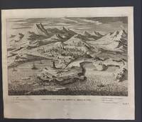
A PROSPECT OF THE TOWN AND HARBOUR OF TRIPOLI IN SYRIA (LEBANON)
by TRIPOLI - LEBANON - Original Antique Etching
- Used
- very good
- first
- Condition
- Used - Very Good
- Edition
- First English Edition
- Binding
- Unknown
- Quantity Available
- 1
- Seller
-
Tel-Aviv, Israel
- Item Price
-
$180.00
Show Details
Description:
1730. First English Edition . No Binding. Very Good. I.B.Martin. ORIGINAL ANTIQUE ETCHING (copper plate) dated 1730, of Tripoli in Lebanon, as seen from the sea. Drawn by I.B.Martin in 1729 (date appears at the right bottom). Nr. 1 on the map indicates the CASTLE (site of former Crusaders' CITADEL of RAYMOND DE SAINT GILLES, also known as Qala'at Sanjil and Qala'at Tarablus ).- Very good impression. Original centerfold. Size of image in cm 43,8 x 27,5 (inch 17,1 x 10,3) . Whole leaf: 46,5 x 39cm (18,3" x 15,3"). Untrimmed large margins. Very few tiny ageing stains at center bottom of outer margins. VERY GOOD AND FRESH CONDITION. (ANCIENT CITY TOPOGRAPHY TARABULUS ASH-SHAM PHOENICIA)
Item Price
$180.00

More Photos
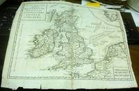
Britannicae Insulae: Antique map of Great Britain
by Robert de Vaugondy
- Used
- very good
- Condition
- Used - Very Good
- Quantity Available
- 1
- Seller
-
Providence, Seychelles
- Item Price
-
$175.00
Show Details
Description:
FULL TITLE: Britannicae, Insulae in quibus Albion Seu Britannia Major, et Ivernia seu Britannia Minor juxta Ptolemaei mentem divisae tùm in suas majores partes, tùm in populos exhibentur, à Nicolao sanson Christ, Regis Geographo, Revisae, et ad observationes astronomicas redactae, accurante Robert de Vaugondy filio, gum Privilegio Regis'DATE PRINTED: 1750 IMAGE SIZE: Approx 50.0 x 55.0cm, 19.5 x 21.5 inches (Large); Please note that this is a folding map.TYPE: Large antique 18th-century atlas map, printed on thick, good quality paper. partially hand-colored.CONDITION: Good; suitable for framing. Please check the scan for any blemishes prior to making your purchase. Virtually all antiquarian maps and prints are subject to some normal aging due to use and time which is not obtrusive unless otherwise stated. We offer a no-questions-asked return policy.AUTHENTICITY: This is an authentic historic map, published at the date stated above. It is not a modern copy.VERSO: Short map title printed on the…
Read More Item Price
$175.00
Nuova Carta dell' Isole Britanniche divise nei tre Regni d'Inghilterra, di Scozia, e d'Irlanda by [L'Isle (Guillaume de)]
by [L'Isle (Guillaume de)]
- Used
- very good
- Condition
- Used - Very Good
- Binding
- Unknown
- Quantity Available
- 1
- Seller
-
Binghamton, New York, United States
- Item Price
-
$205.00
Show Details
Description:
Albrizzi, 1743, Venice. Very Good. Prompt shipment, with tracking. we ship in CLEAN SECURE NEW boxes Full margins, uncolored, slight tearing to edges, folded with some repair to two folds. Very good. *
Item Price
$205.00
![Southern Regions; [Published in Colton's General Atlas, 1861 as No. XIII]](https://d3525k1ryd2155.cloudfront.net/h/589/126/1453126589.0.m.jpg)
More Photos
Southern Regions; [Published in Colton's General Atlas, 1861 as No. XIII]
by Colton, George
- Used
- very good
- first
- Condition
- Used - Very Good
- Edition
- First State, later printing
- Binding
- Unknown
- Quantity Available
- 1
- Seller
-
Sebastopol, California, United States
- Item Price
-
$168.00
Show Details
Description:
New York: J. H. Colton & Co, 1855. First State, later printing. Very Good. [14x11in Neatline, 17.5x14.25in Sheet]; Map with distinctive Colton borders of discovered Antarctic features of few land features and the ice covered coast line as of 1855 from reports of explorers; Some age-toning and light stains along edges [Rumsey Collection 2441.009]. The Southern Regions map was initially drawn and engraved for publication in Colton's General Atlas of 1855. Colton reissued atlases in different formats, pagination and collation over the years. This map was from the 1861 issue and distinctive in the roman numerals format and number placement. The map has not been altered since 1855. The details on the map are from six explorations over a 70 year period from 1773 to 1843. The continent of Antarctica was completely unknown prior to James Cook's second voyage of the Resolution and Adventure 1772-1775. Others followed fifty years later Bellinghausen, 1820, Briscoe 1831-32, Kemp 1833, Wilkes 1940, and Ross…
Read More Item Price
$168.00

More Photos
Mediterranean, the Dardanelles (ancient Hellespont): Nautical map of the Dardanelles
by Hydrographic Office of Great Britain
- Used
- Condition
- Used - Good-
- Edition
- Large corrections Sept. 1880. Small corrections to 1914.
- Quantity Available
- 1
- Seller
-
Providence, Seychelles
- Item Price
-
$175.00
Show Details
Description:
Hydrographic chart of the Dardanelles Strait region, Turkey. Relief is shown by spot heights and hachures. Depths are shown by bathymetric isolines and soundings.The chart is damaged along the edges with some tears in the middle. Wrinkles and some pencil inscriptions, signs of aging and wear. Please see the photos. Free Shipping included. The map will be shipped in a strong cardboard tube.If you have any questions or inquiries, please don't hesitate to contact us!
Item Price
$175.00

More Photos
Historical map of Nantucket, 1869.
by Ferdinand C. Ewer
- Used
- Condition
- Used
- Quantity Available
- 1
- Seller
-
Houston, Texas, United States
- Item Price
-
$250.00
Show Details
Description:
[Nantucket] [Cape Cod] Ferdinand C. Ewer. Historical map of Nantucket, 1869. [Boston]: [publisher not identified] [Circa 1886-1900] Map 22 x 35 cm. Has been folded. Splits at folds, else very good. OCLC shows ten holdings (Harvard; Salem St.; Univ. Chicago; Boston Public. Lib.; RB Hayes Ctr; Brown Univ.; Dartmouth; Bryn Mawr Col.; Wisc. Hist. Soc. [2]) Surveyed and drawn by the Rev. F.C. Ewer, D.D., 1869. Reduced copy issued by the Old Colony Railroad as an advertisement of its Old Colony Line of steamboats to the Island. Includes historical text. Will frame and display well.
Item Price
$250.00

More Photos
A Bird’s-Eye View of Narragansett Bay.
by J.A. & R.A. Reid
- Used
- Condition
- Used
- Quantity Available
- 1
- Seller
-
Houston, Texas, United States
- Item Price
-
$175.00
Show Details
Description:
A Bird's-Eye View of Narragansett Bay. [Providence, R.I.]: J.A. & R.A. Reid. 1888. Black and white bird's eye map. 50 x 72 cm. Has been folded. Very good. OCLC shows no holdings. Probably produced for Reid's Illustrated Sea Side Souvenir, which is itself very scarce, with only two holdings for any years (Brown Univ. & RI Hist. Soc.). A nice display piece. Inset of light house and sailboat. Index of places.
Item Price
$175.00

Stock Photo: Cover May Be Different
Historical and Philosophical Memoirs of Pius the Sixth and of His Pontificate: Down to the Period of His Retirement Into Tuscany. . . Translated from the French (1799 Volume 1
by Bourgoing, Jean-Francois
- Used
- Condition
- UsedVeryGood
- ISBN 13
- 9781145823662
- ISBN 10
- 1145823661
- Quantity Available
- 1
- Seller
-
Bensalem, Pennsylvania, United States
- Item Price
-
$33.17
Show Details
Description:
UsedVeryGood. Minor shelf wear
Item Price
$33.17
Stock Photo: Cover May Be Different
Historical and Philosophical Memoirs of Pius the Sixth and of His Pontificate: Down to the Period of His Retirement Into Tuscany. . . Translated from the French (1799 Volume 1
by Bourgoing, Jean-Francois
- Used
- Condition
- UsedVeryGood
- ISBN 13
- 9781145823662
- ISBN 10
- 1145823661
- Quantity Available
- 1
- Seller
-
Philadelphia, Pennsylvania, United States
- Item Price
-
$33.17
Show Details
Description:
UsedVeryGood. signs of little wear on the cover.
Item Price
$33.17
Stock Photo: Cover May Be Different
Historical and Philosophical Memoirs of Pius the Sixth and of His Pontificate: Down to the Period of His Retirement Into Tuscany. . . Translated from the French (1799 Volume 1
by Bourgoing, Jean-Francois
- Used
- Condition
- UsedLikeNew
- ISBN 13
- 9781145823662
- ISBN 10
- 1145823661
- Quantity Available
- 1
- Seller
-
Bensalem, Pennsylvania, United States
- Item Price
-
$33.51
Show Details
Description:
UsedLikeNew. Remainder mark
Item Price
$33.51
Stock Photo: Cover May Be Different
Historical and Philosophical Memoirs of Pius the Sixth and of His Pontificate: Down to the Period of His Retirement Into Tuscany. . . Translated from the French (1799 Volume 1
by Bourgoing, Jean-Francois
- Used
- Condition
- UsedLikeNew
- ISBN 13
- 9781145823662
- ISBN 10
- 1145823661
- Quantity Available
- 1
- Seller
-
Philadelphia, Pennsylvania, United States
- Item Price
-
$33.51
Show Details
Description:
UsedLikeNew. Remainder mark
Item Price
$33.51
Stock Photo: Cover May Be Different
Historical and Philosophical Memoirs of Pius the Sixth and of His Pontificate: Down to the Period of His Retirement Into Tuscany. . . Translated from the French (1799 Volume 1
by Bourgoing, Jean-Francois
- New
- Condition
- New
- ISBN 13
- 9781145823662
- ISBN 10
- 1145823661
- Quantity Available
- 1
- Seller
-
Bensalem, Pennsylvania, United States
- Item Price
-
$33.85
Show Details
Description:
New. .
Item Price
$33.85

Stock Photo: Cover May Be Different
Tableau De L'espagne Moderna, 1... (French Edition)
by Bourgoing, Jean-Francois
- Used
- Condition
- UsedVeryGood
- ISBN 13
- 9781278930763
- ISBN 10
- 1278930760
- Quantity Available
- 1
- Seller
-
Bensalem, Pennsylvania, United States
- Item Price
-
$34.79
Show Details
Description:
UsedVeryGood. signs of little wear on the cover.
Item Price
$34.79

Stock Photo: Cover May Be Different
Nouveau Voyage En Espagne Ou Le Tableau De L'tat Actuel De Cette Monarchie... (French Edition)
by Bourgoing, Jean-François de
- Used
- Condition
- UsedVeryGood
- ISBN 13
- 9781271723232
- ISBN 10
- 1271723239
- Quantity Available
- 1
- Seller
-
Bensalem, Pennsylvania, United States
- Item Price
-
$34.79
Show Details
Description:
UsedVeryGood. Minor shelf wear
Item Price
$34.79
Stock Photo: Cover May Be Different
Nouveau Voyage En Espagne Ou Le Tableau De L'tat Actuel De Cette Monarchie... (French Edition)
by Bourgoing, Jean-François de
- Used
- Condition
- UsedVeryGood
- ISBN 13
- 9781271723232
- ISBN 10
- 1271723239
- Quantity Available
- 1
- Seller
-
Philadelphia, Pennsylvania, United States
- Item Price
-
$34.79
Show Details
Description:
UsedVeryGood. signs of little wear on the cover.
Item Price
$34.79

Tableau De L'Espagne Moderne,
by Jean-François Bourgoing
- New
- Paperback
- Condition
- New
- Binding
- Paperback
- ISBN 13
- 9781022797291
- ISBN 10
- 1022797298
- Quantity Available
- 10
- Seller
-
Southport, Merseyside, United Kingdom
- Item Price
-
$21.81
Show Details
Description:
Paperback / softback. New.
Item Price
$21.81
Stock Photo: Cover May Be Different
Nouveau Voyage En Espagne Ou Le Tableau De L'tat Actuel De Cette Monarchie... (French Edition)
by Bourgoing, Jean-François de
- Used
- Condition
- UsedLikeNew
- ISBN 13
- 9781271723232
- ISBN 10
- 1271723239
- Quantity Available
- 1
- Seller
-
Bensalem, Pennsylvania, United States
- Item Price
-
$35.14
Show Details
Description:
UsedLikeNew. Remainder mark
Item Price
$35.14

More Photos
The Sky and the Forest
by Forester, C.S
- Used
- very good
- Hardcover
- first
- Condition
- Used - Very Good
- Jacket Condition
- Very Good
- Edition
- First Edition
- Binding
- Hardcover
- Quantity Available
- 1
- Seller
-
Salem, Oregon, United States
- Item Price
-
$34.89$20.93Save $13.96!
Show Details
Description:
C.S. Forester: The Sky and the Forest. Little, Brown and Company, Boston. Stated First Edition First Printing Thus August, 1948. Cover price $2.75. Used. VG BOOK/VG UNCLIPPED DUST JACKET. A story of a central Africa. By C.S. Forester, author of the Admiral Hornblower series.
Item Price
$34.89$20.93
Save $13.96
!
![Alaska and Klondike Region; [With inset of Klondike Region on the Upper Yukon detail] [From an...](https://d3525k1ryd2155.cloudfront.net/h/062/537/1339537062.0.m.jpg)
Alaska and Klondike Region; [With inset of Klondike Region on the Upper Yukon detail] [From an atlas, "Gazetteer of Alaska and Yukon Region " pp. 105 and 106]
by Miller, J. Martin
- Used
- very good
- Condition
- Used - Very Good
- Edition
- Unknown
- Quantity Available
- 1
- Seller
-
Sebastopol, California, United States
- Item Price
-
$39.00
Show Details
Description:
Chicago: J. Martin Miller, 1899. Unknown. Map. Very Good. [Map copyright 1899, printing date of Atlas later] [19.875x15.125in]; Colored map of Alaska with steamer routes from Portland and Seattle, insets of the Klondike Region on the Upper Yukon and Western portion of Aleutian Islands; On verso index of places and names with two large black and white images; Age toning to all edges, water stain marks on bottom, slight printing offset of colors, small chips and closed tears to lower edge;.
Item Price
$39.00

Zemepis Sveta - Monsunova Asie
by De La Blache, P. Vidal; Gallois, L
- Used
- Hardcover
- Condition
- Used - Very Good Condition
- Jacket Condition
- No Dust Jacket
- Binding
- Hardcover
- Quantity Available
- 1
- Seller
-
Oak Point, Texas, United States
- Item Price
-
$60.00
Show Details
Description:
Aventinum, Prague, Czechoslovakia, 1930. Hardcover. Very Good Condition/No Dust Jacket. Text entirely in Czech. Geography book on Asia with numerous photographs and maps. 1931 edition also available. Size: 4mo - over 9 3/4" - 12" tall. 400 pp. Pages are yellowed, but are tight and clean. Moderate shelfwear along the spine. Corners are lightly bumped. Quantity Available: 1. Shipped Weight: 3-5 pounds. Category: Travel & Places; Non-English Language::Czech; Pictures of this item not already displayed here available upon request. Inventory No: 001227. . Additional shipping charges may apply.
Item Price
$60.00

Zemepis Sveta - Monsunova Asie
by De La Blache, P. Vidal; Gallois, L
- Used
- Hardcover
- Condition
- Used - Very Good Condition
- Jacket Condition
- No Dust Jacket
- Binding
- Hardcover
- Quantity Available
- 1
- Seller
-
Oak Point, Texas, United States
- Item Price
-
$60.00
Show Details
Description:
Aventinum, Prague, Czechoslovakia, 1931. Hardcover. Very Good Condition/No Dust Jacket. Text entirely in Czech. Geography book on Asia with numerous photographs and maps. 1930 edition also available. Size: 4mo - over 9 3/4" - 12" tall. 400 pp. Pages are yellowed, but are tight and clean. Moderate shelfwear along the spine. Corners are lightly bumped. Quantity Available: 1. Shipped Weight: 3-5 pounds. Category: Travel & Places; Non-English Language::Czech; Pictures of this item not already displayed here available upon request. Inventory No: 001228. . Additional shipping charges may apply.
Item Price
$60.00

Asia from the Best Authorities, Russell, ca.1800
by Russell
- Used
- Condition
- Used
- Quantity Available
- 1
- Seller
-
Plymouth, Devon, United Kingdom
- Item Price
-
$24.94
Show Details
Description:
Russell, J. : Asia from the Best Authorities. Nd but ca.1800. From "A New Geographical, Historical and Commercial Grammar and Present State of Several Kingdoms of the World". Copper engraving. Size approx 200 x 230mm. Two neat folds. Some age colouring to edges, otherwise clean and bright. Includes Arabia, India, Borneo, Japan, China and eastern Russia.
Item Price
$24.94

North America from the Best Authorities, Russell, ca.1800
by Russell
- Used
- Condition
- Used
- Quantity Available
- 1
- Seller
-
Plymouth, Devon, United Kingdom
- Item Price
-
$24.94
Show Details
Description:
Russell, J. : A General Map of North America from the Best Authorities. Nd but ca.1800. From "A New Geographical, Historical and Commercial Grammar and Present State of Several Kingdoms of the World." Copper engraving. Size approx 200 x 230mm. Two neat folds. Some age colouring to edges, otherwise very clean and bright.
Item Price
$24.94
![MAP OF UTAH [Territory]](https://d3525k1ryd2155.cloudfront.net/h/836/461/1485461836.0.m.jpg)
More Photos
MAP OF UTAH [Territory]
- Used
- Condition
- Used - Very Good-
- Edition
- Original
- Quantity Available
- 1
- Seller
-
Williamsburg, Virginia, United States
- Item Price
-
$65.00
Show Details
Description:
New York, Richmond, Chicago, & Toledo: H. H. Hardesty, 1885. Original color lithographed map printed by Rand, McNally & Company, Engravers and published in HARDESTY'S HISTORICAL AND GEOGRAPHICAL ENCYCLOPEDIA: SPECIAL VIRGINIA EDITION. 19 3/8 inches by 13 1/4 inches on a 21" X 14 1/2" sheet. The map depicts the Territory of Utah in its final form--large areas had been removed and ceded to Nevada, Colorado, Wyoming, and Nebraska since Utah became a U. S. Territory in 1850. The issue of polygamy prevented statehood until it was finally granted in 1896. This map features railroads and topography and uses color to set off counties from each other. Unlike most atlas maps of the period, this map identifies most small towns. The map is guaranteed to be moe than 135 years old. The map is in about very good condition: generally clean and bright, with slight toning of paper and one faint water stain near the center-left edge of the map.. Original. Single Sheet. Very Good-. Elephant…
Read More Item Price
$65.00

Philips Special Map of the Nile, The Advance on Khartum and the Environs of Omdurman. Cc1900
by George Philips and Son,
- Used
- Condition
- Used
- Quantity Available
- 1
- Seller
-
Plymouth, Devon, United Kingdom
- Item Price
-
$32.43
Show Details
Description:
Philips Special map of the Nile illustrating the Advance on Khartum [Khartoum] with an enlargement of the environs of Omdurman [Omdur]. George Philips and Son, London and Liverpool Ca 1900. 580mm x 900mm folded map. Front title wrapper has come loose, not affecting map area. Three maps are displayed within the sheet. Map1. Map of the Nile Valley 520mm x 300mm showing the approaches of Khartum. Scale 1inch to 100 Geographical miles. Coloured indicating Possessions and Protectorates of European Powers. Map 2. Special map of the Nile from Dongola to Khartum. Scale 16 miles to the inch. Coloured. In set in this map is Map3. Environs of Omdurman, Scale 5 statute miles to the inch. Some small breaks at some folds, not affecting imagery or use of map. Title label is damaged, the map is clean and bright, probably unused. A very interesting record.
Item Price
$32.43

Last Tales
by Dinesen, Isak
- Used
- very good
- Hardcover
- first
- Condition
- Used - Very Good
- Jacket Condition
- Good+
- Edition
- First Edition
- Binding
- Hardcover
- Quantity Available
- 1
- Seller
-
Salem, Oregon, United States
- Item Price
-
$120.00$72.00Save $48.00!
Show Details
Description:
Dinesen, Isak: Last Tales, A Collection of Twelve New Tales of Compelling Beauty 1957, Random House. First Edition. Stated First Printing Thus. Used. Very Good/Good+ original red dust jacket, price-clipped. Jacket states 11/57 on front flap. 5 3/4 X
Item Price
$120.00$72.00
Save $48.00
!

The Adventure of Wrangel Island
by Vilhjalmur Stefansson
- Used
- good
- Hardcover
- first
- Condition
- Used - Good
- Jacket Condition
- No DJ Included
- Edition
- First Edition
- Binding
- Hardcover
- Quantity Available
- 1
- Seller
-
Salem, Oregon, United States
- Item Price
-
$124.89$74.93Save $49.96!
Show Details
Description:
The Adventure of Wrangel Island, Alaska (1925 Macmillan 1st Edition) HISTORY OF ALASKA. EXLIB. Good Condition/ No DJ included. Fold-out map affixed to binding at the back of the book has never been opened. The story of the (unsuccessful) attempted colonization of Wrangel Island Alaska. 413 pages plus appendix, Index. Titling is still bright. A clean, solid copy. Scarce.
Item Price
$124.89$74.93
Save $49.96
!