Description:
Boston: Little, Brown And Company, 1910. 1st Edition 2nd Printing. Hardcover. Good. Xviii, Map, 490Pp. + Many Plates. Green Cloth, Gilt, Plate Mounted On Front Cover, Top Edge Gilt. Wear, Slight Soiling And Six Small Faint Damp Spots On Front Cover, Hinge Lightly Cracked Before Half Title Page, A Few Pages Roughly Opened With Edge Tears.
Bartholomew's Contoured Road Map of of England & Wales. by Folding Map
by Folding Map
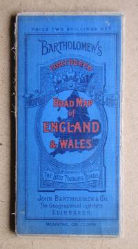
Bartholomew's Contoured Road Map of of England & Wales.
by Folding Map
- Used
- good
- Hardcover
John Bartholomew & Son Ltd. Undated, circa 1930/40s. Mounted on cloth. Complete, but with some splits on the folds.. Good.
-
Bookseller
Independent bookstores
 (GB)
(GB)
- Book Condition Used - Good
- Binding Hardcover
- Publisher John Bartholomew & Son Ltd.
- Keywords England Wales Road Map.
Sicily In Shadow And In Sun; The Earthquake And The American Relief Work
by Howe, Maud; Photographs And Drawings By John Elliott, Folding Map
- Used
- good
- Hardcover
- first
- Condition
- Used - Good
- Edition
- 1st Edition 2nd Printing
- Binding
- Hardcover
- Quantity Available
- 1
- Seller
-
Pasadena, California, United States
- Item Price
-
$17.50
Show Details
Item Price
$17.50

Independent Iraq: A Study in Iraqi Politics since 1932
by Khadduri, Majid; Illustrated by Folding map. [Illustrator]
- Used
- very good
- Hardcover
- Condition
- Used - Very Good
- Binding
- Hardcover
- Quantity Available
- 1
- Seller
-
Boonsboro, Maryland, United States
- Item Price
-
$24.45
Show Details
Description:
Oxford University Press, 1960-01-01. Hardcover. Very Good. 0x0x0. Hardcover and dust jacket. Tears to jacket with loss. Good binding and cover. Shelf wear. Light foxing to edges. Small markings on jacket. Rear gutter weakened. viii, 388 p., folded map, 22 cm. <br> "Here, for this first time, an Iraqi writer attempts to give the inside story of contemporary political developments in his country.
Item Price
$24.45
Independent Iraq: A Study in Iraqi Politics since 1932
by Khadduri, Majid; Illustrated by Folding map. [Illustrator]
- Used
- Hardcover
- Condition
- Used - ex-lib
- Binding
- Hardcover
- Quantity Available
- 1
- Seller
-
Staten Island, New York, United States
- Item Price
-
$29.50
Show Details
Description:
Oxford University Press, 1960-01-01. Hardcover. ex-lib. [nb65 Jan25T3] has edge wear/bumped corners, no marks on pages. tight and sturdy ex-lib copy.
Item Price
$29.50

The Significance Of Anthony Trollope.
by Nichols, Spencer Van Bokkelen; Folding Map By George Muendel
- Used
- near fine
- Hardcover
- first
- Condition
- Used - Near Fine
- Edition
- 1st Edition
- Binding
- Hardcover
- Quantity Available
- 1
- Seller
-
Pasadena, California, United States
- Item Price
-
$27.50
Show Details
Description:
New York: Douglas C. Mcmurtrie, 1925. 1st Edition . Hardcover. Near Fine. 59 Pp. Blue Cloth Spine, Gilt, Blue Boards. Folding Color Map And Two Plates. Near Fine, Touches Of Wear At Corners, Two Short Tears At Edges Of Folding Frontispiece Map.
Item Price
$27.50
Travels in Arabia Deserta. New Definitive Edition [2 Volumes in 1]
by Doughty, Charles Montagu; Introduction by T. E. Lawrence; Folding Map in Pocket at Rear [Illustrator]
- Used
- very good
- Hardcover
- Condition
- Used - Very Good
- Edition
- Third Edition
- Binding
- Hardcover
- Quantity Available
- 1
- Seller
-
Boonsboro, Maryland, United States
- Item Price
-
$31.35
Show Details
Description:
Random House, 1921. Third Edition. hardcover. Very Good. 0x0x0. Bound in publisher's cloth. Hardcover. Good binding and cover. Clean, unmarked pages. Thin paper edition, in one volume.
Item Price
$31.35
Karte der Eisenbahnen Mittel-Europa's mit Angabe Sammtlicher Bahnstationen. Hauptpost- und Dampfschifffahrts-VerbindungenDampfschiff-Verbindungen;
by [Folding Map] [H. Muller]
- Used
- good
- Hardcover
- Condition
- Used - Good
- Binding
- Hardcover
- Quantity Available
- 1
- Seller
-
Hamden, Connecticut, United States
- Item Price
-
$35.00
Show Details
Description:
Glogan: Carl Flemming, 1871. Good. Cloth-backed folding map, mounted in sections. Measures approx. 81 x 97cm. (folded to 17 x 13cm.). Front cover detached. Covers most of the western portion (15th to 41st Parallel) of continental Europe, excluding the Iberian Peninsula, Scandinavia (except Denmark), and peninsular Italy.81 x 97 cm., folded to 17 x 13 cm.
Item Price
$35.00
The Riviera. Painted & Described by....
by Scott, William and Illustrated by Color plates; folding map
- Used
- good
- Hardcover
- first
- Condition
- Used - Good
- Binding
- Hardcover
- Quantity Available
- 1
- Seller
-
Silver Spring, Maryland, United States
- Item Price
-
$49.50
Show Details
Description:
Hardcover. Good. [FIRST EDITION] London: A. & C. Black, 1907. Hardcover in the original blue cloth with a design blocked in gilt and printed in red and green, with all titles stamped in gilt, t.e.g., etc. Thick 8vo. 22.5cm; xii, 235, [4 - ads] pages, illustrated with 75 color plates, 16 head and tail pieces in black and white and rear folding map. One of 3000 first edition copies. Light soiling and wear to covers, minor foxing, toning to pre-lims, else very good overall condition; no owner marking, NOT EX-LIBRARY (froc)
Item Price
$49.50

Trinity County Vacation Guide (With Very Large Multi-Fold Map)
by Photographs, Folding Map
- Used
- Fine
- Paperback
- Condition
- Used - Fine
- Binding
- Paperback
- Quantity Available
- 1
- Seller
-
Pasadena, California, United States
- Item Price
-
$55.00
Show Details
Description:
Yreka Ca: News-Journal Litho, 1969. Soft cover. Fine. 40 Pp + Very Large Multi-Fold Map At Rear.
Item Price
$55.00

More Photos
Hodegos tes Attikes: Alphavetikon Heureterion Topographikou CHartou Attikes
by [Folding map , with some text]
- Used
- very good
- Hardcover
- Condition
- Used - Very Good
- Binding
- Hardcover
- Quantity Available
- 1
- Seller
-
Hamden, Connecticut, United States
- Item Price
-
$75.00
Show Details
Description:
En Athenais: Ekdotikos Oikos Eleutheroudakes, 1923. Hardcover. Very Good. Large 78 cm x 95 cm cloth-backed folding map, plus 51p. text. Original green cloth. 20 cm. Text pages somewhat browned. Former owner's name inked in upper right corner of title-page. Linen backing seems somewhat thin along some folds. Map of the Attic Peninsula region in Greece. Greek text.
Item Price
$75.00

World At A Glance. The Personal Map
by [Australia] Folding map
- Used
- Condition
- Used
- Quantity Available
- 1
- Seller
-
Garrison, New York, United States
- Item Price
-
$95.00
Show Details
Description:
New York: American Map Company, 1940. Folding color map of the world with tabs across the bottom, each with on a different topic, so that one can choose a tab and open the map to the desired region. Including: Near East, Europe, North America, Far East, United States (eastern portion), United States (western portion), Statistical Data, East Indies (Western Australia), South Pacific (Eastern Australia), Central and South America, So. Africa, and India. Heavy card stock with title in red on black at front cover, and with a table of Air Line Distances between Important Cities on the rear cover. Folds into 3x6.35". With the original envelope. Folds out to 34.75 x 6.25". Color printed both sides. Printed at base of index: "Boundaries.. ...those recognized at the start of WW2 September 1939", very good condition.
Item Price
$95.00