
Click for full-size.
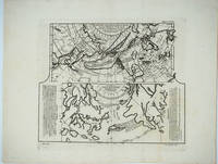
Carte des Nouvelles Decouvertes // Extrait d'une Carte Japonoise de l'Univers
by Vaugondy, Robert de Didier, 1723-1786; Philippe Bauche 1700-1773 & Engelbert Kaempfer 1651-1716
- Used
- Condition
- See description
- Seller
-
Garrison, New York, United States
Payment Methods Accepted
About This Item
Livourne, 1779. Maps. A map of Asia, Canada, Japan and the Arctic regions, with two maps on one sheet. The upper map shows the European view of the northern Pacific, showing western North America from New Orleans west with a clearly depicted Mer de l'Ouest, to Kamchatka and northern Japan. The lower map shows the Japanese perception of the same region, with very sketchy and inaccurate features in North America and a larger showing of the Japanese islands. The Japanese map has no depiction of Alaska.
Copper engraving with two maps on one sheet. Includes text. Upper margin: "Suppl. 6e carte." Lower margin: "189 190"; "R. Spadaccini Sculp." This conforms with the edition at the Univ. of British Columbia mccormick_174. According to UBC "This atlas map removed from source: Robert de Vaugondy, Didier. [Recueil de 10 cartes...traitant particulierement de l'Amerique du Nord et des regions arctiques, d'apres les relations les plus authentiques depuis le commencement du 17 siecle, reproduites...]. 1 p.l., 10 fold. maps. 8. Livourne, 1779."
The title translates - Map of new discoveries, prepared by Phil. Buache, the King's Geographer, presented to the Academy of Science August 9, 1752 and approved in its meeting on the 6th of September following. (and) Excerpt from a Japanese map of the universe brought to Europe by Kaempfer and deposited in the cabinet of the late Mr. Han-Sloane, president of the Royal Society of London.
The map also appeared in a supplement to Diderot and d'Alembert's "Encyclopédie" (without the lower margin text.)
Printed area measures 12 1/2 x 14", on paper 15 3/4 x 20 1/4". Very good overall, with some unevenness in paper production causing the lower margin to look somewhat mottled.
Reviews
(Log in or Create an Account first!)
Details
- Seller
- Antipodean Books, Maps & Prints
 (US)
(US)
- Seller's Inventory #
- 25866
- Title
- Carte des Nouvelles Decouvertes // Extrait d'une Carte Japonoise de l'Univers
- Author
- Vaugondy, Robert de Didier, 1723-1786; Philippe Bauche 1700-1773 & Engelbert Kaempfer 1651-1716
- Format/Binding
- Maps
- Book Condition
- Used
- Quantity Available
- 1
- Place of Publication
- Livourne
- Date Published
- 1779
- Bookseller catalogs
- MAPS; ARCTIC;
Terms of Sale
Antipodean Books, Maps & Prints
30 day return guarantee, with full refund including shipping costs for up to 10 days after delivery if an item arrives mis-described or damaged.
About the Seller
Antipodean Books, Maps & Prints
Biblio member since 2009
Garrison, New York
About Antipodean Books, Maps & Prints
Booksellers for over 40 years, members of prominent trade associations (ABAA, ILAB, ANZAAB, IMCOS, ANZMS, PBFA). We are located at Garrison NY, a stone's throw from the Metro North Hudson line train, just over 1 hr. from NYC on the banks of the Hudson River. Books, maps, prints & ephemera bought & sold.
Glossary
Some terminology that may be used in this description includes:
- New
- A new book is a book previously not circulated to a buyer. Although a new book is typically free of any faults or defects, "new"...
This Book’s Categories

Collecting Nebula Award Winners of the 1980s
The Nebula Award has been awarded to stories in the Science Fiction and Fantasy genre every year since 1966. Learn about the winners of the 1980s!

Collecting food and drink books
Nothing quite whets the appetite for rare and collectible books like old and vintage cookbooks. Be sure to check out our cook books and food section of our rare book room.