
Click for full-size.
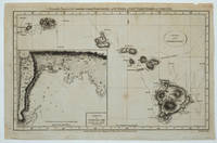
Chart of the Sandwich Isles : Sketch of Karakakooa Bay
by [Cook / Hogg / Anderson]
- Used
- Condition
- See description
- Seller
-
Garrison, New York, United States
Payment Methods Accepted
About This Item
London: Alexander Hogg at the Kings Arms, No. 16, Paternoster Row, 1790. Attractive map of the Hawaiian Islands with Cook's tracks charged, as well as an inset map of Karakakooa Bay marked, "Here Capt. Cook was killed". Copper engraving, 13 3/4 x 9" with small margins. T. Conder Sculpt. "Accurately Engraved for Anderson's Large Folio Edition of the Whole of Capt. Cook's Voyages & Complete". Small corner replaced lower left barely affecting the plate mark, a tiny nick in the upper margin outside of the plate mark. Overall a very good copy.
Reviews
(Log in or Create an Account first!)
Details
- Bookseller
- Antipodean Books, Maps & Prints
 (US)
(US)
- Bookseller's Inventory #
- 23494
- Title
- Chart of the Sandwich Isles : Sketch of Karakakooa Bay
- Author
- [Cook / Hogg / Anderson]
- Book Condition
- Used
- Quantity Available
- 1
- Publisher
- Alexander Hogg at the Kings Arms, No. 16, Paternoster Row
- Place of Publication
- London
- Date Published
- 1790
- Bookseller catalogs
- HAWAII; MAPS; COOK, JAMES;
Terms of Sale
Antipodean Books, Maps & Prints
30 day return guarantee, with full refund including shipping costs for up to 10 days after delivery if an item arrives mis-described or damaged.
About the Seller
Antipodean Books, Maps & Prints
Biblio member since 2009
Garrison, New York
About Antipodean Books, Maps & Prints
Booksellers for over 40 years, members of prominent trade associations (ABAA, ILAB, ANZAAB, IMCOS, ANZMS, PBFA). We are located at Garrison NY, a stone's throw from the Metro North Hudson line train, just over 1 hr. from NYC on the banks of the Hudson River. Books, maps, prints & ephemera bought & sold.
Glossary
Some terminology that may be used in this description includes:
This Book’s Categories

Positive Representation Matters
Books transmit cultural values and can shape the views of society. Learn more about the history of American literature in Collecting Children’s Literature by Writers and Educators of the Harlem Renaissance.

Collecting and identifying signed letters and holographic documents
Many authors and other famous literary figures wrote and signed letters by hand, and you can find a great collection of them in the Biblio rare book room. See our great collection of handwritten letters and holographic documents