Description:
Prentice Hall, 2004. Hardcover. Good. Former library book; Pages can have notes/highlighting. Spine may show signs of wear. ~ ThriftBooks: Read More, Spend Less.Dust jacket quality is not guaranteed.
Cornwall by JENNER, Thomas - 1657
by JENNER, Thomas
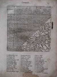
Cornwall
by JENNER, Thomas
- Used
- good
- first
c1657, 1657. Map. Good. Dimensions : 100 x 100 mm. Actual map (triangular) : 75 x 74 mm. Staining and worm track to the lower part of the text, although the engraved map very good with a good plate mark. Miniature map, first published in 1643. This edition is from " A Book of the Names of all Parishes," published with text. It is suggested that this series of maps were issued to be used by the two armies during the English Civil War, and possibly the hast that this was done, would account for the number of rather quaint mistakes in the engraving of the map; for instance St. Agnes and ( Zennor ) have been transposed in each others place, St. Ives is located just above St. Agnes, and Padstow is found in the position of Hayle. Also the name of St. Michael's Mount has been engraved backwards, suggesting the engraver was copying directly onto the copper plate. The first edition is distinguished from this edition by the lack of text printed beneath the actual engraved map. Quixley, " Antique Maps of Cornwall and the Isles of Scilly," No. 10
-
Seller
Independent bookstores
 (GB)
(GB)
- Format/Binding Map
- Book Condition Used - Good
- Quantity Available 1
- Publisher c1657
- Date Published 1657
- Keywords CORNWALL. ENGLISH CIVIL WAR. ANTIQUE MAPS. CARTOGRAPHY. ROADS. THUMB NAIL MINIATURE

Stock Photo: Cover May Be Different
Prentice Hall Science Explorer Earth's Waters Student Edition Third Edition 2005
by Jenner, Jan; Miaoulis, Ioannis; Cyr, Martha; Padilla, Michael J.; Wellnitz, Thomas R
- Used
- good
- Hardcover
- Condition
- Used - Good
- Binding
- Hardcover
- ISBN 10 / ISBN 13
- 9780131150935 / 0131150936
- Quantity Available
- 2
- Seller
-
Seattle, Washington, United States
- Item Price
-
$7.55
Show Details
Item Price
$7.55
Stock Photo: Cover May Be Different
Prentice Hall Science Explorer Earth's Waters Student Edition Third Edition 2005
by Jenner, Jan; Miaoulis, Ioannis; Cyr, Martha; Padilla, Michael J.; Wellnitz, Thomas R
- Used
- Acceptable
- Hardcover
- Condition
- Used - Acceptable
- Binding
- Hardcover
- ISBN 10 / ISBN 13
- 9780131150935 / 0131150936
- Quantity Available
- 4
- Seller
-
Seattle, Washington, United States
- Item Price
-
$7.55
Show Details
Description:
Prentice Hall, 2004. Hardcover. Acceptable. Readable copy. Pages may have considerable notes/highlighting. ~ ThriftBooks: Read More, Spend Less.Dust jacket quality is not guaranteed.
Item Price
$7.55
Stock Photo: Cover May Be Different
Prentice Hall Science Explorer Earth's Waters Student Edition Third Edition 2005
by Jenner, Jan; Miaoulis, Ioannis; Cyr, Martha; Padilla, Michael J.; Wellnitz, Thomas R
- Used
- very good
- Hardcover
- Condition
- Used - Very Good
- Binding
- Hardcover
- ISBN 10 / ISBN 13
- 9780131150935 / 0131150936
- Quantity Available
- 3
- Seller
-
Seattle, Washington, United States
- Item Price
-
$7.55
Show Details
Description:
Prentice Hall, 2004. Hardcover. Very Good. May have limited writing in cover pages. Pages are unmarked. ~ ThriftBooks: Read More, Spend Less.Dust jacket quality is not guaranteed.
Item Price
$7.55
Stock Photo: Cover May Be Different
Prentice Hall Science Explorer Earth's Waters Student Edition Third Edition 2005
by Jenner, Jan; Miaoulis, Ioannis; Cyr, Martha; Padilla, Michael J.; Wellnitz, Thomas R
- Used
- good
- Hardcover
- Condition
- Used - Good
- Binding
- Hardcover
- ISBN 10 / ISBN 13
- 9780131150935 / 0131150936
- Quantity Available
- 6
- Seller
-
Seattle, Washington, United States
- Item Price
-
$7.61
Show Details
Description:
Prentice Hall, 2004. Hardcover. Good. Pages can have notes/highlighting. Spine may show signs of wear. ~ ThriftBooks: Read More, Spend Less.Dust jacket quality is not guaranteed.
Item Price
$7.61

Science Explorer C2009 Lep Student Edition Earth
by Jenner, Jan; Kemp, Andrew C., Ph.D.; Pasachoff, Jay M.; Simons, Barbara Brooks; Wellnitz, Thomas R
- Used
- good
- Hardcover
- Condition
- Used - Good
- Binding
- Hardcover
- ISBN 10 / ISBN 13
- 9780133668582 / 0133668584
- Quantity Available
- 4
- Seller
-
Seattle, Washington, United States
- Item Price
-
$8.98
Show Details
Description:
Prentice Hall, 2007. Hardcover. Good. Pages can have notes/highlighting. Spine may show signs of wear. ~ ThriftBooks: Read More, Spend Less.Dust jacket quality is not guaranteed.
Item Price
$8.98
Stock Photo: Cover May Be Different
Science Explorer: Earth's Waters
by Jan Jenner; Ioannis Miaoulis; Martha Cyr; Michael J. Padilla; Thomas R. Wellnitz
- Used
- good
- Hardcover
- Condition
- Used - Good
- Binding
- Hardcover
- ISBN 10 / ISBN 13
- 9780131150935 / 0131150936
- Quantity Available
- 1
- Seller
-
HOUSTON, Texas, United States
- Item Price
-
$9.85
Show Details
Description:
Pearson Prentice Hall, 2004-04. Hardcover. Good.
Item Price
$9.85

Stock Photo: Cover May Be Different
Kellie's Diary: Death of Innocence
by Perkins, Angeline; Jenner, Thomas
- Used
- very good
- Paperback
- Condition
- Used - Very Good
- Binding
- Paperback
- ISBN 10 / ISBN 13
- 9781508681946 / 1508681945
- Quantity Available
- 1
- Seller
-
Seattle, Washington, United States
- Item Price
-
$10.03
Show Details
Description:
Createspace Independent Publishing Platform, 2015. Paperback. Very Good. May have limited writing in cover pages. Pages are unmarked. ~ ThriftBooks: Read More, Spend Less.Dust jacket quality is not guaranteed.
Item Price
$10.03

Stock Photo: Cover May Be Different
Science Explorer
by Jenner, Jan; Wellnitz, Thomas R
- Used
- good
- Hardcover
- Condition
- Used - GOOD
- Jacket Condition
- NOT ISSUED
- Binding
- Hardcover
- ISBN 10 / ISBN 13
- 9780132011518 / 0132011514
- Quantity Available
- 1
- Seller
-
Armada, Michigan, United States
- Item Price
-
$5.88
Show Details
Description:
PRENTICE HALL, 2007. Hard Cover Hardcover. GOOD/NOT ISSUED. • Binding: Hard Cover • 2007 • Clean tight pages. Tight square binding. Edgewear. Some scuffs in cover's shine. •
Item Price
$5.88

Stock Photo: Cover May Be Different
Antipsychotic Drugs and Their Side-Effects (Neuroscience Perspectives)
by Editor-Thomas R.E. Barnes; Series Editor-Peter Jenner
- Used
- Hardcover
- Condition
- Used: Good
- Binding
- Hardcover
- ISBN 10 / ISBN 13
- 9780120790357 / 0120790351
- Quantity Available
- 1
- Seller
-
HOUSTON, Texas, United States
- Item Price
-
$13.69
Show Details
Description:
Academic Press, 1994-01-20. Hardcover. Used: Good.
Item Price
$13.69

Stock Photo: Cover May Be Different
Focus on Earth Science California Edition (California Science Explorer)
by Jones, Linda Cronin, Ph.D.; Simons, Barbara Brooks; Wellnitz, Thomas R.; Jenner, Jan; Lisowski, Marylin
- Used
- Acceptable
- Hardcover
- Condition
- Used - Acceptable
- Binding
- Hardcover
- ISBN 10 / ISBN 13
- 9780132012744 / 013201274X
- Quantity Available
- 6
- Seller
-
los angeles, California, United States
- Item Price
-
$9.97
Show Details
Description:
Pearson Prentice Hall, 2007-03-30. Hardcover. Acceptable. 9x1x11. ACCEPTABLE CONDITION.SOME VISIBLE COVER DAMAGE. SOME WATER DAMAGE.
Item Price
$9.97