Description:
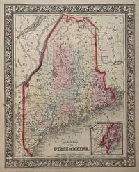
Unbound, colored engraved map, decorative boarder, 14"x 11". Slight toning and aging; bright and clear, and in otherwise very good shape. Maps are wrapped with acid free board, or in rigid sleeves. The Mitchell family started to produce atlases in 1846, and continued into the early 1890s. Around 1860, S. Augustus Mitchell Jr. took over, and the atlas would be called Mitchell's New General Atlas. This is an attractive colorful single page map of Maine from the 1870 installment of that atlas. Good detail, and Portland is featured in an inset.. Ristow 311-313.
County Map of the State of Maine by MITCHELL, Samuel Augustus Jr - 1869
by MITCHELL, Samuel Augustus Jr
Similar copies are shown below.
Similar copies are shown to the right.

County Map of the State of Maine
by MITCHELL, Samuel Augustus Jr
- Used
Philadelphia: Mitchell, Samuel Augustus Jr., 1869. unbound. very good(+). Map. Steel engraving with original hand coloring. Image measures 13 3/8" x 10 5/8".<br/> <br/> Classic map of Maine published in 1869, hand-colored to show counties. Major towns and cities, routes, railroads and waterways are labeled. Features an inset of Portland Harbor. In excellent condition with minor overall aging. Light crease to lower left corner.<br> <Br> Samuel Augustus Mitchell Sr. (1792-1868) was one of the pioneers in American cartography of the 19th century and led the conversion of engraved map plates to more affordable lithographic plates. S. Augustus Mitchell Jr. continued his father's successful mapmaking and publishing business, and was one of the most prolific and renowned 19th century American publishers.<br/> <br/>
-
Bookseller
Argosy Book Store
 (US)
(US)
- Format/Binding Unbound
- Book Condition Used - very good(+)
- Quantity Available 1
- Publisher Mitchell, Samuel Augustus Jr.
- Place of Publication Philadelphia
- Date Published 1869
- Keywords mitchell
We have 2 copies available starting at $75.00.

County Map of the State of Maine.
by Mitchell, Samuel Augustus Jr
- Used
- Condition
- Used
- Quantity Available
- 1
- Seller
-
Florham Park, New Jersey, United States
- Item Price
-
$75.00
Show Details
Item Price
$75.00
County Map of the State of Maine
by MITCHELL, Samuel Augustus Jr
- Used
- Condition
- Used
- Quantity Available
- 1
- Seller
-
New York, New York, United States
- Item Price
-
$125.00
Show Details
Description:
Philadelphia: Mitchell, Samuel Augustus Jr., 1860. unbound. Map. Steel engraving with original hand coloring. Image measures 13 3/8" x 10 5/8".<br/> <br/> Lovely map of Maine published in 1860 divided into counties. Shows major towns and cities, routes, railroads and waterways. Features an inset of Portland Harbor. In excellent condition, with a minor chip to lower margin not affecting the image.<br> <br> Samuel Augustus Mitchell Sr. (1792-1868) was one of the leaders in American cartography of the 19th century and pioneered the conversion of engraved map plates to more affordable lithographic plates. His son, Samuel Augustus Mitchell Jr. continued his father's successful mapmaking and publishing business, and was one of the most prolific and renowned 19th century American publishers.<br/> <br/>
Item Price
$125.00