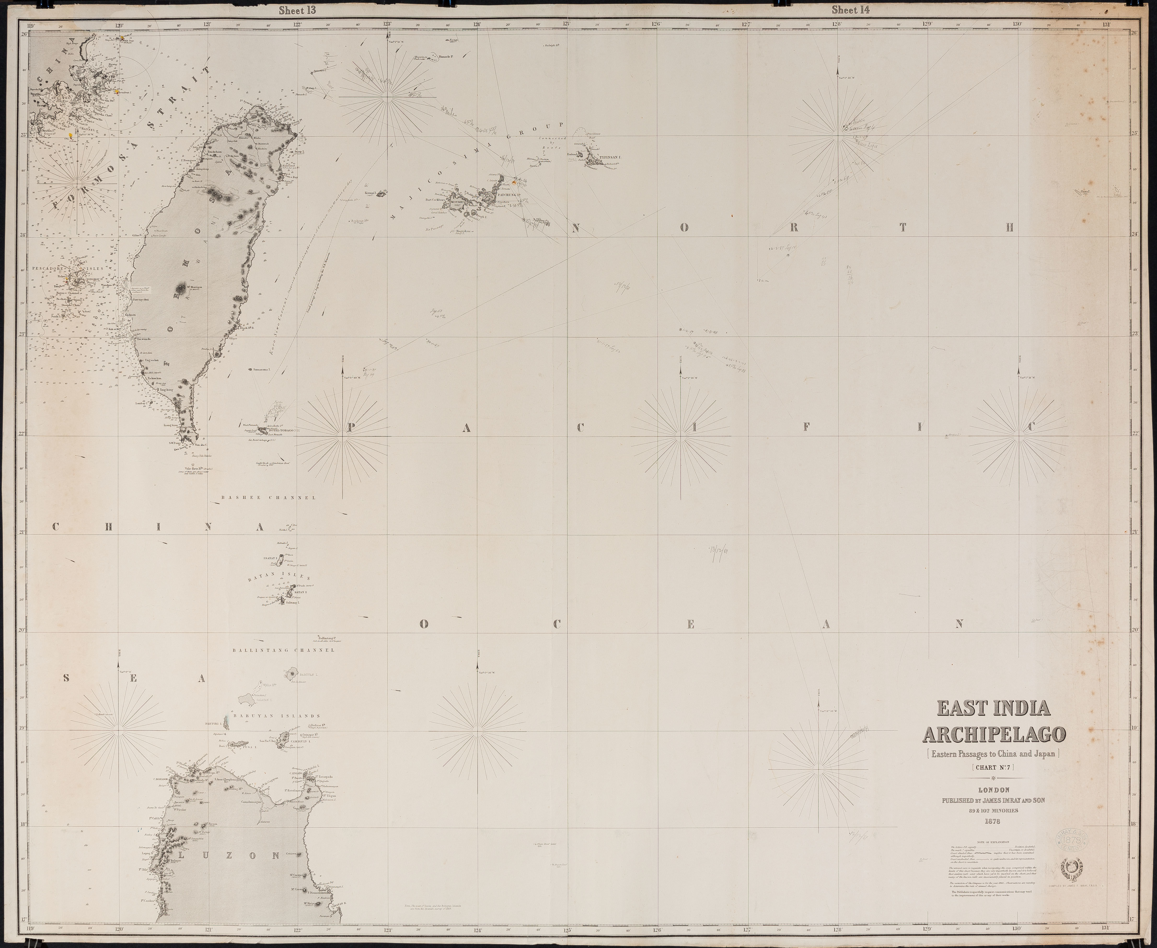
Click for full-size.
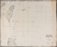
East India Archipelago Chart No. 7 (1878): Formosa
by James Imray and Son
- Used
- Condition
- See description
- Seller
-
FRAMINGHAM, Massachusetts, United States
Payment Methods Accepted
About This Item
Chart Details:
black and white engraving, navigation lights marked with red and yellow, blue backed
Blue ink stamp next to title block: "Imray & Son London 1878"
Publisher's original paper label glued to back of chart
condition: as found rolled, top left corner approx. 2" piece missing that includes some of perimeter printed border of chart, overall a clean chart with some spotting on edges, some spotting in vicinity of title block, paper toned along right vertical edge chart, edges overall in good condition, this chart was used to plot several voyages and has manuscript pencil notes with dates
Reviews
(Log in or Create an Account first!)
Details
- Bookseller
- Original Antique Maps
 (US)
(US)
- Bookseller's Inventory #
- 308
- Title
- East India Archipelago Chart No. 7 (1878)
- Author
- James Imray and Son
- Book Condition
- Used
- Quantity Available
- 1
- Publisher
- James Imray & Son
- Place of Publication
- London
- Date Published
- 1878
- Weight
- 0.00 lbs
- Keywords
- British Admiralty, Formosa, Taiwan, 19th c. Straits of Formosa
Terms of Sale
Original Antique Maps
30 day return guarantee, with full refund including original shipping costs for up to 30 days after delivery if an item arrives misdescribed. If an item arrives damaged, please contact Original Antique Maps immediately to report the damage and discuss whether the original shipping materials may still be used to return the item and for return shipping instructions. Original Antique Maps will fully refund buyer's payments and pay for the return shipping of any damaged item. Buyer will be paid following receipt by Original Antique Maps of the returned item. Otherwise, returns as per www.spackantiquemaps.com.Buyer will be advised of shipping and handling charges that exceed standard charges to buyer.
About the Seller
Original Antique Maps
Biblio member since 2020
FRAMINGHAM, Massachusetts
About Original Antique Maps
Rare and unusual 18th and 19th century Americana, American and International maps, atlases, prints, nautical charts and manuscript maps. My interests include American 19th century newspapers and manuscript materials such as letters. Maps of the 20th c. including advertising, transit and urban planning are of special interest. Original art on paper in its many forms, including posters and field studies for ultimate print publication.
Glossary
Some terminology that may be used in this description includes:
This Book’s Categories

Vertigo Comics
Vertigo Comics, an imprint of DC Comics, is being retired in 2020 after a 27 year run of groundbreaking comics. The imprint was DC’s home for mature tales that were often horror-themed or otherwise dark in nature. Learn more about Vertigo, home of V for Vendetta, Sandman, and Fables.

Collecting Little Golden Books
These iconic childrens board books are collectible if you can find an original in great condition! Learn more about collecting Little Golden Books.
Also Recommended
-
-
-

-
-

Save 10% on every purchase!
Join the Bibliophiles’ Club and start saving 10% on every book.
$29.95 / Year