Description:
New York: Army Information Branch, Army Service Forces, 1945. Good + condition. 185th Week of U.S. Participation in the War. Monday, 2 July, 1945. Volume IV, No. 11F. Large printed color double sided folding map. A two color map on one side of Borneo showing elevation at the right side, and with printed information on the recapture of Borneo by the Allies. A smaller map shows the Pacific Arena with Borneo and Sarawak printed in green. Below this is a b&w printed photo illustration of the port area of Balikpapan with caption: "Scene of extensive oil installations before Jap occupation early in 1942 has been target of recent heavy Allied air and sea blows." On the verso is color poster of an American woman holding a hammer, having just nailed up some lucky horseshoes, and saying of her spouse, "Now ... If He Will Just Save Some Money ... everything will be OK". These war maps were issued by the US War Department in WWII to the public and to military personnel as visual guides to campaigns, and…
Read More Equal - Area Projection of The World. (Verso: New Map of Europe). by WORLD MAP - WORLD WAR II) - No date. Between 1933 and 1939.
by WORLD MAP - WORLD WAR II)

Equal - Area Projection of The World. (Verso: New Map of Europe).
by WORLD MAP - WORLD WAR II)
- Used
New York.: American Map Company, Inc.. No date. Between 1933 and 1939.. Color poster world map with photographic illustrations of world leaders above and below, sheet 36 1/4 x 28 inches, color map of Europe on verso. Light creasing to edges, very good condition. A striking and informative world map with photo illustrations of 61 world leaders and the flags of their countries. Franklin D. Roosevelt and John N. Garner are the U.S president and vice president. Adolf Hitler, Hirohito and Chiang Kai-Shek appear as does President Benavides of Peru whose term ended in December 1939. The maps are copyright The Geographical Publishing Co. of Chicago. A fascinating snapshot of the world on the brink of World War II. .
-
Bookseller
Independent bookstores
 (US)
(US)
- Book Condition Used
- Publisher American Map Company, Inc.
- Place of Publication New York.
- Date Published No date. Between 1933 and 1939.
- Keywords Europe, map, pictorial map, world, World War II, zz_22_WS_40_off, zz_ListOn_eBay, zzmapg, zzprintg

More Photos
WWII Newsmap for the Armed Forces. Borneo. VE Day + 8 Weeks
by [WWII; Map]
- Used
- Condition
- Used - Good + condition
- Quantity Available
- 1
- Seller
-
Garrison, New York, United States
- Item Price
-
$75.00
Show Details
Item Price
$75.00
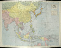
The Daily Telegraph War Map of the Far East. Daily Telegraph War Map No. 11.
by [ASIA - WORLD WAR II MAP]
- Used
- Condition
- Used
- Quantity Available
- 1
- Seller
-
Canberra, Australian Capital Territory, Australia
- Item Price
-
$81.32
Show Details
Description:
London.: Hutchinson & Co.. (Circa1940).. Full colour folding map, 70.7 x 93 cms; 76 x 101.2 cms (sheet), original folds, short fold splits, previous owner's neat title markings on the verso, but the map in very good condition. A "Geographia" map of the war theatre in Asia and the Pacific including the northernmost coast of Australia. Showing railways and canals, roads and steamer routes, oilfields and pipe lines and a key to the unfederated states of Malaya. The Spratley Islands are marked as French and Thai territorial claims within French Indo China are marked. .
Item Price
$81.32

More Photos
World News of the Week. Monday, Apr. 13, 1942. Covering period Apr. 3 to Apr. 9. Military Edition.
by [WORLD MAP - WORLD WAR II]
- Used
- Condition
- Used
- Edition
- Volume 4, No. 32.
- Quantity Available
- 1
- Seller
-
Canberra, Australian Capital Territory, Australia
- Item Price
-
$81.32
Show Details
Description:
Army Orientation Course. / News Map of the Week, Inc.. Volume 4, No. 32.. 13 April1942.. Folding colour pictorial map on sheet 88 x 119 cms, (blank on verso), inset maps (two photographic), diagrams and black and white photographic illustrations, descriptive text, top edge chipped, a few short edge tears and lower corner torn (no loss), pinholes at the corners, inoffensive tidemark at a lower corner, in good condition. Colour world map showing political boundaries and military events of World War II, from April 3 to 9, 1942. with descriptive text beneath including: the loss of two British Cruisers off Ceylon; the occupation of Bataan by the Japanese and their landing on Manus; Japanese war tactics revealed by Malay prisoners and the increasing importance of Central Africa to the Allied war effort. The. Map is indexed according to these notes. Two inset maps of Europe chart Hitler's gains in 1941 and activity on the Russian Front. Additional diagrams on the main world map show war spending and the…
Read More Item Price
$81.32
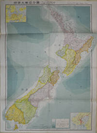
標準大東亜分図: 17 ニュージーランド編. [Hyōjun Dai tōa bunzu: 17 Nyuujiirandohen]. Standard Maps of Greater East Asia: 17 New Zealand].
by [JAPANESE WORLD WAR II MAP OF NEW ZEALAND]
- Used
- Condition
- Used
- Quantity Available
- 1
- Seller
-
Canberra, Australian Capital Territory, Australia
- Item Price
-
$130.12
Show Details
Description:
Tokyo: 統制社(Tosei-sha). 昭和18 [Showa]1943.. Folding colour map of New Zealand with inset of Auckland and Wellington top and bottom corners,1:2,000,000 scale, little light browning. Original envelope worn with closed tears. 54 x 76.5cm. Good copy. Scale plan of New Zealand printed by Tosei in 1943. The map legend shows infrastructure deemed important to the Land Survey Bureau of the General Staff Headquaters of the Imperial Japanese army, such as boundaries, powerlines, quarries and mines; railroads, sea-routes, etc. .
Item Price
$130.12

WWII Newsmap for the Armed Forces. China Southeast Coast
by [WWII; Map]
- Used
- Condition
- Used - Very good condition
- Quantity Available
- 1
- Seller
-
Garrison, New York, United States
- Item Price
-
$175.00
Show Details
Description:
New York: Army Information Branch, Army Service Forces, 1944. Very good condition. Large printed color folding map of China and its southeast coast, extending from Shanghai down to Formosa and Hainan and French Indo China. With inset maps of the vicinities of Hong Kong, Canton, Swatow, Foochow, Wenchow and Shanghai printed down the right side. These war maps were issued by the US War Department in WWII to the public and to military personnel as visual guides to campaigns, and usually featured the theater of conflict, and often included text descriptions of war related events. 47 x 35", printed on one side. Volume III, No. 518 printed at lower left. Some small cracks at fold intersections; the word "China" in manuscript on verso.
Item Price
$175.00

More Photos
Moscow to Berlin. Japan and Adjacent Regions. US Army Orientation map
by [WWII; Map]
- Used
- Condition
- Used - Very good overall
- Quantity Available
- 1
- Seller
-
Garrison, New York, United States
- Item Price
-
$175.00
Show Details
Description:
Washington DC: Army Orientation Branch, Morale Services Division, 1945. Very good overall. A very large double sided US Army Map WWII created by the Orientation Branch, whose mission was to strengthen the leadership of junior officers and to give every soldier a sense of personal mission in the part his unit was playing. Orientation map series 9 & 10. 'Moscow to Berlin", Orientation Map Series No. 9, showing Europe from Finland down to Bulgaria and from Berlin over to Moscow, and centered on Poland with legend showing 'Pre War boundaries' as dashed line and 'Boundaries Established after 1939' as dotted line. Verso with 'Japan and Adjacent Regions", Orientation Map Series No. 10, showing Japan as well as the USSR, Manchuria, and the Chinese coast down to Taiwan. Legend shows International Boundaries and Provincial Boundaries, & Railroads. Printed in green and black. Double sided map, both sides printed in color. 40 1/2 x 56". Short tears along one edge, otherwise very bright and clean, period…
Read More Item Price
$175.00

More Photos
標準大東亜分図: 19 インド篇. [Hyōjun daitōa-bun-zu: 19 Indo-hen]. [Standard Maps of Greater East Asia: 19 - India].
by [WWII JAPANESE MAP OF INDIA]
- Used
- Condition
- Used
- Quantity Available
- 1
- Seller
-
Canberra, Australian Capital Territory, Australia
- Item Price
-
$162.65
Show Details
Description:
Tokyo: 統制社(Tosei-sha). Showa 18 [1943].. Large folding colour map of India, 76.2 x 54.5 cm (including margins), two inset maps of Calcutta and New Delhi, legend references regional borders, powerlines, quarries, mines, railroads and sea-routes; with the original envelope, 26.3 x 19.4 cm, the both very good examples. Scale plan of India showing surrounding countries. Printed by Toseisha in 1943, this wartime map shows infrastructure for the Land Survey Bureau of the General Staff Headquarters of the Imperial Japanese Army. .
Item Price
$162.65
More Photos
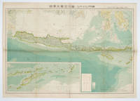
標準大東亜分図: 10 ジャワ・小スンダ列島篇. [Hyōjun daitōa-bun-zu: 10 Jawa shōsundarettō-hen]. [Standard Maps of Greater East Asia: 10 Jawa and the Sunda Archipelago].
by [JAPANESE WWII MAP OF JAVA]
- Used
- Condition
- Used
- Quantity Available
- 1
- Seller
-
Canberra, Australian Capital Territory, Australia
- Item Price
-
$162.65
Show Details
Description:
Tokyo (東京): 統制社(Tosei-sha). 昭和18年、1943.. Folding colour map of Java with inset of the Sunda Archipelago lower right. a little occasional browning or staining. Original paper envelope included .
Item Price
$162.65
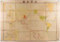
世界戦下の世界全図. [Sekai senka no sekai zenzu]. [Map of the World under the World War].
by [JAPANESE MAP - WORLD WAR II]
- Used
- Condition
- Used
- Quantity Available
- 1
- Seller
-
Canberra, Australian Capital Territory, Australia
- Item Price
-
$191.93
Show Details
Description:
東京. [Tokyo].: 盛文館. [Seibunkan].. Circa1942.. Colour map, 75 x 110cm, folds to 28 x 19cm. Some light browning, somewhat heavier along a few folds. A good copy. This map, which was most likely published around 1942 or 1943, depicts the world during the global conflict. Japan is positioned in the centre, and its territories are coloured in red. In Southeast Asia, Japanese-occupied areas, including Singapore, the Philippines, and the Dutch East Indies, are marked with red. Two inset maps display Europe and the Japanese-occupied area to the south as the "Southern Co-Prosperity Sphere." The map is folded to 28 x 19 cm, and its cover features the national flags of Japan, Nazi Germany, Italy, the Soviet Union, Britain, and the United States, arranged artistically. .
Item Price
$191.93
More Photos
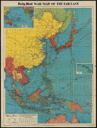
The Daily Mail War Map of the Far East.
by [WORLD WAR II MAP OF EAST ASIA]
- Used
- Condition
- Used
- Quantity Available
- 1
- Seller
-
Canberra, Australian Capital Territory, Australia
- Item Price
-
$211.44
Show Details
Description:
London.: George Philip & Son.. 1944.. Full colour folding map, 101.5 x 76cm (sheet), inset maps, legend, folding into title wrapper 25.7 x 19.4 cms, covers a little dusty and discoloured, a few short fold splits (without loss), but the map in very good, bright condition. Map of the Pacific Theatre of World War II, with borders drawn as they stood in 1937 - complete with Chinese claims on Mongolia, Tuva and Tibet. Shows transportation routes, principal railways, oil fields, Allied naval bases, territory occupied by the British Empire, French Empire and the United States. This map shows only the northernmost section of Australia which allows for much better detail of the countries of East Asia. Small inset map of the Hawaiin Islands at mid right. Inset map of the Pacific Ocean at upper left. .
Item Price
$211.44