Description:
Paris Circa 1840: A. Combette, 1840. Original Antique Map . Single Sheet. Very Good +. 21" x 14 1/4. Large Color Views By Raimond Bonheur. Original Decorative Map 21" X 14 1/4" Of North America Showing The United States As Claiming Much Of British Colombia, With The West Coast Of The Usa Continuing Well Into Present-Day Canada; Texas As A Republic; Guatemala Encompassing All Of Central America South Of Chiapas And Belize And North Of Panama. Large Panels At Sides With Detailed, Attractive And Well Colored Views Of People, Wildlife, Vegetation, High Mountains, Etc.Colors Very Bright And Well-Placed.
Geographische Beschreibung Van Dem Wanderschaft Der Apostelen Und Reysen Des H. Apostels Pauli [Original Antique Engraved Map] -
![Geographische Beschreibung Van Dem Wanderschaft Der Apostelen Und Reysen Des H. Apostels Pauli [Original Antique Engraved Map] -](https://d3525k1ryd2155.cloudfront.net/h/738/513/637513738.0.m.jpg)
Geographische Beschreibung van dem Wanderschaft der Apostelen und Reysen des H. Apostels Pauli [Original Antique Engraved Map]
- Used
- near fine
Germany Circa 1680, 1680. Original Antique Map . Single Sheet. Near Fine. 18.6 x 12.6. Size: 18.6 X 12.6 Inches (47.3 X 32.0 Cm). Decorative Map Describing The Apostle Paul's Travels By Boat From Jerusalem To Rome, Showing The Region From Italy To The Persian Gulf. Nine Graphic Panels Across The Top And Bottom Depict 26 Events From The Book Of Acts. German Text On Verso. A Complete Original Map, 1/4" Chip To Design At Upper Left, Some Loss Of Paper At Edges Not Affecting The Design. Professionally Cleaned, De-Acidified, Pressed And Laid Down On Archival Board By A Museum-Experienced Conservator.
-
Seller
Arroyo Seco Books
 (US)
(US)
- Format/Binding Single Sheet
- Book Condition Used - Near Fine
- Edition Original Antique Map
- Place of Publication Germany Circa 1680
- Date Published 1680
- Keywords General
- Size 18.6 x 12.6

Amerique Septrionale [ Original Map From The Atlas Universal Illustre, By Levasseur, V. / Laguillermie]
by Levasseur, V. / Laguillermie
- Used
- Condition
- Used - Very Good +
- Edition
- Original Antique Map
- Binding
- Unknown
- Quantity Available
- 1
- Seller
-
Pasadena, California, United States
- Item Price
-
$135.00
Show Details
Item Price
$135.00
Cercle De Souabe [Original Antique Map from the Atlas Universal of 1757, with Lake Constance, Stuttgart, Augsburg, Etc.]
by Vaugondy, Robert
- Used
- near fine
- Condition
- Used - Near Fine
- Edition
- Original Antique Map
- Binding
- Unknown
- Quantity Available
- 1
- Seller
-
Pasadena, California, United States
- Item Price
-
$360.00
Show Details
Description:
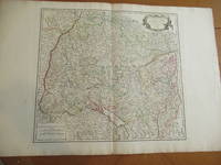
Paris: Robert Vaugondy, 1751. Original Antique Map . Single Sheet. Near Fine. 22" x 32. Original very large antique map, extracted from an atlas. Very detailed, with hundreds of towns and villages, probably all in existence at the time, and showing jurisdictional boundaries as well.
Item Price
$360.00
![Americae Sive Novi Orbis, Nova Descriptio [Reprinted Engraved Antique Map]](https://d3525k1ryd2155.cloudfront.net/h/585/523/637523585.0.m.jpg)
Americae Sive Novi Orbis, Nova Descriptio [Reprinted Engraved Antique Map]
by Ortelius, Abraham
- Used
- near fine
- Condition
- Used - Near Fine
- Jacket Condition
- No Jacket
- Edition
- 5th or later Edition
- Binding
- Unknown
- Quantity Available
- 1
- Seller
-
Pasadena, California, United States
- Item Price
-
$270.00
Show Details
Description:
(: Abraham Ortelius (Original 1587 But This A Reprint), 1587. 5th or later Edition . No Binding. Near Fine/No Jacket. 19" x 17. Image Size: 18 7/8" X 13 3/4". Text "Cum Privilegio Decennali Ab. Ortelius Delineab. Et Excudeb. 1587" At Lower Right. However, This Must Be A Late Eighteenth Century To Twentieth Century Reprint, Printed On Wove Paper, Sheet Never Placed In An Atlas. Strong Impression And Color, Minor Loss Of A Millimeter Depth In A Tiny Area Of Lower Left Margin, Otherwise Undamaged. Margins Irregular, Up To 1" Deep. Professionally Cleaned And De-Acidified With Archival Materials By A Museum-Experienced Conservator.
Item Price
$270.00

More Photos
Arab navigation in the Indian Ocean before the coming of the Portuguese
by Ahmad ibn Majid al-Sadi , G.R. Tibbetts
- Used
- Hardcover
- first
- Condition
- Very Good: Cover some light shelf wear, inside as new
- Edition
- First Edition
- Binding
- Hardcover
- ISBN 13
- 9780718909000
- ISBN 10
- 0718909003
- Quantity Available
- 1
- Seller
-
Berg en dal, Netherlands
- Item Price
-
$258.41
Show Details
Description:
Ahmad ibn Majid al-Sadi, G.R. Tibbetts - Arab Navigation in the Indian Ocean before the coming of the Portuguese - London, The Royal Asiatic Society of Great Britain and Ireland; Luzac and Company Ltd, 1971 - First Edition - Hardcover - 614pp + 4 maps (out of 7)- 22x14 cmCondition Very Good: Cover some light shelf wear, inside as new. Four out of seven maps present: Chart of the Arabian Sea, India and the Bay of Bengal, Red Sea and Gulf of Eden, East African CoastIf you have any questions or want to see more pictures, feel free to ask.Your book will be securely packed and shipped with tracking number, signed & insured.
Item Price
$258.41

More Photos
1875 ILLINOIS CENTRAL MAP.: Map of the Illinois Central Railroad and its Connections.
- Used
- Condition
- Used
- Quantity Available
- 1
- Seller
-
Houston, Texas, United States
- Item Price
-
$295.00
Show Details
Description:
[Railroad] Map of the Illinois Central Railroad and its Connections. Chicago: Rand McNally and Company Map Engravers. 1875. Map printed on green paper. 33 x 25 on sheet 40 x 38 cm folded to 9 x 19 cm. Added text printed in green in margins around map. One three inch fold split, else very good.OCLC shows one holding (Newberry Lib.) Relief shown by hachures. Timetables on verso "corrected to June 20th, 1875." Text describing routes and connections on 5 panels on verso: Illinois Central Railroad principal connections -- Illinois Central Railroad Dubuque and Sioux City Line! -- Illinois Central Railroad, the direct route from Chicago to Springfield, Farmer City, Clinton and Mt. Pulaski -- Illinois Central Railroad St. Louis through line -- Illinois Central Railroad New Orleans through line.
Item Price
$295.00

COMPENDIOUS GEOGRAPHICAL AND HISTORICAL GRAMMAR exhibiting a brief survey of the terraqueous globe : and shewing, the situation, extent, boundaries, and divisions of the various countries, their chief towns, mountains, rivers, climates, and productions; their governments, revenues, commerce, and their sea and land forces; likewise, the religion, language, literature, customs, and manners of the respective inhabitants of the different nations: and also, a concise view of the political history of the several empires, kingdoms, and states. Embellished with maps.
- Used
- good
- Hardcover
- Condition
- Used - Good
- Binding
- Hardcover
- Quantity Available
- 1
- Seller
-
Blockley, Gloucestershire, United Kingdom
- Item Price
-
$314.29
Show Details
Description:
London: W.Peacock, 1795. Hardcover. Good. Hand colored in outline Folding Maps (12 + frontis) by Russell. Duodecimo red roan gilt (spine quite chipped down at head/foot & heavily rubbed/tips worn) All Edges Gilt xxii+404pp +(4p index) 2 leaves nearly loose but clean and square. Nice 19th century inscription on FEP. All folding maps crisp and untorn with outline coloring. Maps: Chart of the world - East Indies - Spain and Portugal - France - Italy - Netherlands - United Provinces - German Empire and Switzerland - Prussia and Poland - Dominions of Russia - Sweden, Denmark and Norway - Great Britain and Ireland - States of America.
Item Price
$314.29

Netherlands. Greenville Collins. 1753: Original 18th Century, Hand Coloured Sea Chart. Coast line of Flanders at Calles [Calais] to Der Scheling [Terschelling]of the West Frisian Islands and then Eastern England Margate in Kent to Burnham Flats in Norfolk. Much detail is given of the Thames es
by Greenville Collins
- Used
- very good
- Condition
- Used - Very Good
- Quantity Available
- 1
- Seller
-
Plymouth, Devon, United Kingdom
- Item Price
-
$224.50
Show Details
Description:
Collins, Capt. Greenville: Netherlands, Untitled chart of Holland, Flanders and Eastern England. Ca 1753. Copper engraved chart. Size approx 600mm x 480mm. Good margins, hand coloured, good impression on heavy paper. Coast line of Flanders at Calles [Calais] to Der Scheling [Terschelling]of the West Frisian Islands and then Eastern England Margate in Kent to Burnham Flats in Norfolk. Much detail is given of the Thames estuary and Rotterdam soundings. Depth soundings and rhumb lines indicated. A compass rose is set at the centre of the Chart. Title cartouche "To the Honourable Sir john Ashby Kt. Admiral of the Blew/ This is most humbly dedicated and presented by Capt G Collins". Some age soiling to edges, one small tear, without loss and repaired to centre fold area. A scarce, attractive sea chart in good, bright condition suitable for display.
Item Price
$224.50

More Photos
Plan of the Battle of Waterloo
by Edward Cotton
- Used
- good
- Hardcover
- Condition
- Used - Good
- Binding
- Hardcover
- Quantity Available
- 1
- Seller
-
Boonsboro, Maryland, United States
- Item Price
-
$318.50
Show Details
Description:
1854. Hardcover. Good. Lithograph map with original hand-colored highlights. Approximately 12 1/4 X 12 1/2" on 18 X 18" sheet with extensive printed text at all margins. Title and credit in the map at upper right, good condition with some aging at folds. <br> Original slim 12mo dark green leather-covered board folder with gilt lettering at upper cover. Some scuffing and wear at edges. Additional smaller lithograph map with hand-colored highlights mounted at inside of upper cover. Lengthy 1858 pencil notation of purchase ("on the Field of Waterloo") from Cotton's niece on verso of map.
Item Price
$318.50
Amerique Septrionale [ Original Map From The Atlas Universal Illustre, By Levasseur, V. / Laguillermie]
by Levasseur, V. / Laguillermie
- Used
- Condition
- Used - Very Good +
- Edition
- Original Antique Map
- Binding
- Unknown
- Quantity Available
- 1
- Seller
-
Pasadena, California, United States
- Item Price
-
$135.00
Show Details
Description:
Paris Circa 1840: A. Combette, 1840. Original Antique Map . Single Sheet. Very Good +. 21" x 14 1/4. Large Color Views By Raimond Bonheur. Original Decorative Map 21" X 14 1/4" Of North America Showing The United States As Claiming Much Of British Colombia, With The West Coast Of The Usa Continuing Well Into Present-Day Canada; Texas As A Republic; Guatemala Encompassing All Of Central America South Of Chiapas And Belize And North Of Panama. Large Panels At Sides With Detailed, Attractive And Well Colored Views Of People, Wildlife, Vegetation, High Mountains, Etc.Colors Very Bright And Well-Placed.
Item Price
$135.00
Cercle De Souabe [Original Antique Map from the Atlas Universal of 1757, with Lake Constance, Stuttgart, Augsburg, Etc.]
by Vaugondy, Robert
- Used
- near fine
- Condition
- Used - Near Fine
- Edition
- Original Antique Map
- Binding
- Unknown
- Quantity Available
- 1
- Seller
-
Pasadena, California, United States
- Item Price
-
$360.00
Show Details
Description:
Paris: Robert Vaugondy, 1751. Original Antique Map . Single Sheet. Near Fine. 22" x 32. Original very large antique map, extracted from an atlas. Very detailed, with hundreds of towns and villages, probably all in existence at the time, and showing jurisdictional boundaries as well.
Item Price
$360.00

More Photos
The Sky and the Forest
by Forester, C.S
- Used
- very good
- Hardcover
- first
- Condition
- Used - Very Good
- Jacket Condition
- Very Good
- Edition
- First Edition
- Binding
- Hardcover
- Quantity Available
- 1
- Seller
-
Salem, Oregon, United States
- Item Price
-
$34.89$20.93Save $13.96!
Show Details
Description:
C.S. Forester: The Sky and the Forest. Little, Brown and Company, Boston. Stated First Edition First Printing Thus August, 1948. Cover price $2.75. Used. VG BOOK/VG UNCLIPPED DUST JACKET. A story of a central Africa. By C.S. Forester, author of the Admiral Hornblower series.
Item Price
$34.89$20.93
Save $13.96
!
![Alaska and Klondike Region; [With inset of Klondike Region on the Upper Yukon detail] [From an...](https://d3525k1ryd2155.cloudfront.net/h/062/537/1339537062.0.m.jpg)
Alaska and Klondike Region; [With inset of Klondike Region on the Upper Yukon detail] [From an atlas, "Gazetteer of Alaska and Yukon Region " pp. 105 and 106]
by Miller, J. Martin
- Used
- very good
- Condition
- Used - Very Good
- Edition
- Unknown
- Quantity Available
- 1
- Seller
-
Sebastopol, California, United States
- Item Price
-
$39.00
Show Details
Description:
Chicago: J. Martin Miller, 1899. Unknown. Map. Very Good. [Map copyright 1899, printing date of Atlas later] [19.875x15.125in]; Colored map of Alaska with steamer routes from Portland and Seattle, insets of the Klondike Region on the Upper Yukon and Western portion of Aleutian Islands; On verso index of places and names with two large black and white images; Age toning to all edges, water stain marks on bottom, slight printing offset of colors, small chips and closed tears to lower edge;.
Item Price
$39.00

Zemepis Sveta - Monsunova Asie
by De La Blache, P. Vidal; Gallois, L
- Used
- Hardcover
- Condition
- Used - Very Good Condition
- Jacket Condition
- No Dust Jacket
- Binding
- Hardcover
- Quantity Available
- 1
- Seller
-
Oak Point, Texas, United States
- Item Price
-
$60.00
Show Details
Description:
Aventinum, Prague, Czechoslovakia, 1931. Hardcover. Very Good Condition/No Dust Jacket. Text entirely in Czech. Geography book on Asia with numerous photographs and maps. 1930 edition also available. Size: 4mo - over 9 3/4" - 12" tall. 400 pp. Pages are yellowed, but are tight and clean. Moderate shelfwear along the spine. Corners are lightly bumped. Quantity Available: 1. Shipped Weight: 3-5 pounds. Category: Travel & Places; Non-English Language::Czech; Pictures of this item not already displayed here available upon request. Inventory No: 001228. . Additional shipping charges may apply.
Item Price
$60.00

Zemepis Sveta - Monsunova Asie
by De La Blache, P. Vidal; Gallois, L
- Used
- Hardcover
- Condition
- Used - Very Good Condition
- Jacket Condition
- No Dust Jacket
- Binding
- Hardcover
- Quantity Available
- 1
- Seller
-
Oak Point, Texas, United States
- Item Price
-
$60.00
Show Details
Description:
Aventinum, Prague, Czechoslovakia, 1930. Hardcover. Very Good Condition/No Dust Jacket. Text entirely in Czech. Geography book on Asia with numerous photographs and maps. 1931 edition also available. Size: 4mo - over 9 3/4" - 12" tall. 400 pp. Pages are yellowed, but are tight and clean. Moderate shelfwear along the spine. Corners are lightly bumped. Quantity Available: 1. Shipped Weight: 3-5 pounds. Category: Travel & Places; Non-English Language::Czech; Pictures of this item not already displayed here available upon request. Inventory No: 001227. . Additional shipping charges may apply.
Item Price
$60.00

North America from the Best Authorities, Russell, ca.1800
by Russell
- Used
- Condition
- Used
- Quantity Available
- 1
- Seller
-
Plymouth, Devon, United Kingdom
- Item Price
-
$24.94
Show Details
Description:
Russell, J. : A General Map of North America from the Best Authorities. Nd but ca.1800. From "A New Geographical, Historical and Commercial Grammar and Present State of Several Kingdoms of the World." Copper engraving. Size approx 200 x 230mm. Two neat folds. Some age colouring to edges, otherwise very clean and bright.
Item Price
$24.94

Asia from the Best Authorities, Russell, ca.1800
by Russell
- Used
- Condition
- Used
- Quantity Available
- 1
- Seller
-
Plymouth, Devon, United Kingdom
- Item Price
-
$24.94
Show Details
Description:
Russell, J. : Asia from the Best Authorities. Nd but ca.1800. From "A New Geographical, Historical and Commercial Grammar and Present State of Several Kingdoms of the World". Copper engraving. Size approx 200 x 230mm. Two neat folds. Some age colouring to edges, otherwise clean and bright. Includes Arabia, India, Borneo, Japan, China and eastern Russia.
Item Price
$24.94
![MAP OF UTAH [Territory]](https://d3525k1ryd2155.cloudfront.net/h/836/461/1485461836.0.m.jpg)
More Photos
MAP OF UTAH [Territory]
- Used
- Condition
- Used - Very Good-
- Edition
- Original
- Quantity Available
- 1
- Seller
-
Williamsburg, Virginia, United States
- Item Price
-
$65.00
Show Details
Description:
New York, Richmond, Chicago, & Toledo: H. H. Hardesty, 1885. Original color lithographed map printed by Rand, McNally & Company, Engravers and published in HARDESTY'S HISTORICAL AND GEOGRAPHICAL ENCYCLOPEDIA: SPECIAL VIRGINIA EDITION. 19 3/8 inches by 13 1/4 inches on a 21" X 14 1/2" sheet. The map depicts the Territory of Utah in its final form--large areas had been removed and ceded to Nevada, Colorado, Wyoming, and Nebraska since Utah became a U. S. Territory in 1850. The issue of polygamy prevented statehood until it was finally granted in 1896. This map features railroads and topography and uses color to set off counties from each other. Unlike most atlas maps of the period, this map identifies most small towns. The map is guaranteed to be moe than 135 years old. The map is in about very good condition: generally clean and bright, with slight toning of paper and one faint water stain near the center-left edge of the map.. Original. Single Sheet. Very Good-. Elephant…
Read More Item Price
$65.00

Philips Special Map of the Nile, The Advance on Khartum and the Environs of Omdurman. Cc1900
by George Philips and Son,
- Used
- Condition
- Used
- Quantity Available
- 1
- Seller
-
Plymouth, Devon, United Kingdom
- Item Price
-
$32.43
Show Details
Description:
Philips Special map of the Nile illustrating the Advance on Khartum [Khartoum] with an enlargement of the environs of Omdurman [Omdur]. George Philips and Son, London and Liverpool Ca 1900. 580mm x 900mm folded map. Front title wrapper has come loose, not affecting map area. Three maps are displayed within the sheet. Map1. Map of the Nile Valley 520mm x 300mm showing the approaches of Khartum. Scale 1inch to 100 Geographical miles. Coloured indicating Possessions and Protectorates of European Powers. Map 2. Special map of the Nile from Dongola to Khartum. Scale 16 miles to the inch. Coloured. In set in this map is Map3. Environs of Omdurman, Scale 5 statute miles to the inch. Some small breaks at some folds, not affecting imagery or use of map. Title label is damaged, the map is clean and bright, probably unused. A very interesting record.
Item Price
$32.43

Last Tales
by Dinesen, Isak
- Used
- very good
- Hardcover
- first
- Condition
- Used - Very Good
- Jacket Condition
- Good+
- Edition
- First Edition
- Binding
- Hardcover
- Quantity Available
- 1
- Seller
-
Salem, Oregon, United States
- Item Price
-
$120.00$72.00Save $48.00!
Show Details
Description:
Dinesen, Isak: Last Tales, A Collection of Twelve New Tales of Compelling Beauty 1957, Random House. First Edition. Stated First Printing Thus. Used. Very Good/Good+ original red dust jacket, price-clipped. Jacket states 11/57 on front flap. 5 3/4 X
Item Price
$120.00$72.00
Save $48.00
!

The Adventure of Wrangel Island
by Vilhjalmur Stefansson
- Used
- good
- Hardcover
- first
- Condition
- Used - Good
- Jacket Condition
- No DJ Included
- Edition
- First Edition
- Binding
- Hardcover
- Quantity Available
- 1
- Seller
-
Salem, Oregon, United States
- Item Price
-
$124.89$74.93Save $49.96!
Show Details
Description:
The Adventure of Wrangel Island, Alaska (1925 Macmillan 1st Edition) HISTORY OF ALASKA. EXLIB. Good Condition/ No DJ included. Fold-out map affixed to binding at the back of the book has never been opened. The story of the (unsuccessful) attempted colonization of Wrangel Island Alaska. 413 pages plus appendix, Index. Titling is still bright. A clean, solid copy. Scarce.
Item Price
$124.89$74.93
Save $49.96
!