Description:
Paperback. New.
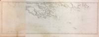
The Kennebec River. by DES BARRES, Joseph Frederick Wallet (1721-1824)
by DES BARRES, Joseph Frederick Wallet (1721-1824)

The Kennebec River.
by DES BARRES, Joseph Frederick Wallet (1721-1824)
- Used
London: Publish'd according to Act of Parliament April 24 1776 by J.F.W. Des Barres Esqr DES BARRES, Joseph Frederick Wallet (1721-1824). The Kennebec River. London: Publish'd according to Act of Parliament April 24 1776 by J.F.W. Des Barres Esqr. 2 sheets, joined (42 4/8 x 30 4/8 inches) A fine chart of the Kennebec or Sagadehoc River watershed in Maine (old vertical folds). A magnificent chart from Des Barres's superb atlas, The Atlantic Neptune, published for the use of the Royal Navy of Great Britain... under the Directions of the Right Honble. the Lords Commissioners of the Admiralty. London, [1774-1779], which included a comprehensive survey of the coasts of Nova Scotia, the coasts and harbors of the Gulf and River of St. Lawrence and the Atlantic coast of North America from New York to Mexico, and New England, in more than 100 engraved charts, views and elevations. Des Barres's service to the British Crown began in about 1752 when he enrolled as a cadet at the Royal Military Academy at Woolwich near London. Founded in 1741 the Academy was established to teach all the branches of mathematics necessary for men who would serve in the Artillery or as Engineers. Des Barres had already received an extensive education in his native Switzerland where he had studied both applied and theoretical mathematics at the University of Basle. Upon the completion of his training he became one of the first officers to be commissioned in the newly formed Royal American Regiment. Thus, it was that at the close of the French and Indian War, Des Barres was sent to America by the British Admiralty to survey the coasts of the Maritime Provinces. These provinces, so recently acquired from France, had never been adequately mapped, and Des Barres spent the next ten years constructing a series of charts of unparalleled accuracy and beauty. Ultimately the project was expanded to include the entire Atlantic and gulf coasts of North America and his findings were published in the monumental "Atlantic Neptune". Copies of The Atlantic Neptune were compiled as they were ordered, principally for naval captains or merchant mariners, and therefore no standard collation exists and no two recorded copies will contain the same compliment of charts, nor be bound in exactly the same sequence. "Nautical charting took an unprecedented leap toward greater precision and graphic sophistication with the publication of Des Barres's Atlantic Neptune... The Neptune provided the first generally accurate charts of many areas, and it was relied upon well into the nineteenth century. Des Barres also standardized many of the symbols, such as for navigational hazards, that are found on nautical charts to this day... Not only were Des Barres's charts technically superior to earlier works, but they were also objects of fine printing and possessed an artistry that transcended their utilitarian purpose. Moreover, this was achieved on works that were often breathtakingly large in scale, with some charts measuring over ten feet in length... Most of the surveys on which the charts of the Neptune were based were conducted between 1763 and 1773. Des Barres was then commissioned to assemble these surveys, which included his own fine work in Nova Scotia, prepare their engraving, and have them bound into usable format. Surveys of the New York and New England areas were carried out by various officers under the command of Major Samuel Holland, one of the most capable of all colonial cartographers... In some but not all cases, Des Barres provided the names of the actual surveyors of the charts... When war with the American colonies broke out, the need for good charts of American waters became imperative, and in the years prior to the war, Des Barres project was given high priority. Between 1776 and 1779, Des Barres and his more than twenty assistants had taken over two London townhouses to complete the Neptune" (Paul E. Cohen and Robert T. Augustyn, Manhattan in Maps 1527-1995, New York, 1997, pp.66-69). .
-
Bookseller
Arader Galleries
 (US)
(US)
- Book Condition Used
- Publisher London: Publish'd according to Act of Parliament April 24 1776 by J.F.W. Des Barres Esqr

Stock Photo: Cover May Be Different
Recapitulation of a Statement Submitted by Lieutenant Colonel Desbarres. for Consideration. Respecting His Services, from the Year 1755, to the Present Time in the Capacity of an Officer and Engineer During the War of 1756.
by Joseph Frederick Wallet Des Barres
- New
- Paperback
- Condition
- New
- Binding
- Paperback
- ISBN 10 / ISBN 13
- 9781377225845 / 1377225844
- Quantity Available
- 10
- Seller
-
Southport, Merseyside, United Kingdom
- Item Price
-
$18.77
Show Details
Item Price
$18.77

Manuscript document in secretarial hand, unsigned, dated Prince Edward Island Government House, July 28, 1812.
by DES BARRES, Joseph Frederick Wallet [1721-1824] [Army officer, military engineer, surveyor, First Lieutenant Governor of Cape Breton, (1784-87), founder of Sydney, and Lieutenant Governor of Prince Edward Island (1804-12)]
- Used
- first
- Condition
- Used
- Edition
- A distinguished military engineer, DesBarres served in the Brit
- Quantity Available
- 1
- Seller
-
Toronto, Ontario, Canada
- Item Price
-
$400.00
Show Details
Description:
[Charlottetown]: 1812. A distinguished military engineer, DesBarres served in the British Army in North America during the Seven Years' War, and participated in the capture of Louisbourg in 1758 and of Quebec in 1759. General James Wolfe used a chart which he prepared of the St. Lawrence River and approaches to Quebec in his assault on the city. From 1763 to 1773 DesBarres surveyed and charted the Atlantic coast from Newfoundland to New York, which resulted in the publication in 1777 of the Atlantic Neptune, a four-volume atlas “which stands as a landmark in Canadian cartographic achievement” (R.J.Morgan, DCB, VI pp. 196) and is considered to be the most important atlas of North America published in the eighteenth century. He went on to become the first Lieutenant Governor of Cape Breton, 1784-87, the founder of Sydney, and the Lieutenant Governor of Prince Edward Island, 1804-12. He faced considerable opposition to his administration in both colonies and with the home government and in each…
Read More Item Price
$400.00
South East Part of Bay of Fundy
by DES BARRES, Joseph Frederick Wallet
- Used
- Condition
- Used - very good(+)
- Quantity Available
- 1
- Seller
-
New York, New York, United States
- Item Price
-
$1,250.00
Show Details
Description:
London: J.F.W. Des Barres. unbound. very good(+). Map. Engraving. 32" x 82". Shows some wear to edges and toning of far left panel.<br/><br/> The Bay of Fundy lies between Canada's Nova Scotia and New Brunswick provinces, and touches the U.S. state of Maine. It's known for extremely high tides. J.F.W. Des Barres (c. 1729-1827) was born in Basle Switzerland but went to military school in England. He became a colonial administrator in Nova Scotia and also served as governor of Quebec. Des Barres was commissioned for the surveying project in 1762, and dedicated ten years to the gathering of the charts and publication of the atlas.<br/><br/>
Item Price
$1,250.00
Spry Harbour; Port Pallisser; Port North; Port Parker; Beaver Harbour; Fleming River.
by Des Barres, Joseph F.W. (Frederick Wallet) 1722-1824
- Used
- Condition
- Used - Very Good, wide margins
- Quantity Available
- 1
- Seller
-
Toronto, Ontario, Canada
- Item Price
-
$2,000.00
Show Details
Description:
London, 1779. Very Good, wide margins. Notes: With oval shaped Inset View showing Cape Spry N. NE…, Beaver Isles…, Westermost Ledge of Pegasus Wing East...The Atlantic Neptune, published for the Royal Navy of Great Britain in London, [1774-1781]. It included a comprehensive survey of the coasts of Nova Scotia, the coasts and harbors of the Gulf and River of St. Lawrence and the Atlantic coast of North America including New York to Mexico, and New England., Size : 723x1035 (mm), 28.46x40.75 (Inches), Coloring: Original Outline Coloring, Category: Maps Canada East Nova Scotia;
Item Price
$2,000.00

Port Campbell
by DES BARRES, Joseph Frederick Wallet
- Used
- Condition
- Used - very good(+)
- Edition
- First
- Quantity Available
- 1
- Seller
-
New York, New York, United States
- Item Price
-
$5,550.00
Show Details
Description:
London, 1776. First. unbound. very good(+). Sea chart. Engraving. Image measures 27.25" x 40.25".<br/><br/> Beautiful rare nautical chart of Port Campbell, SE Nova Scotia. This is the first state and shows settlements and shoals in outline only. Includes the yet named Shelburne Harbour and Roseneath Island (now McNutt Island). Includes description of the shoreline and tides. Map is dated 1776, just before the Loyalists came and settled the area. Published in "The Atlantic Neptune", the first British sea atlas of the eastern coast of North America, hailed for both its accuracy and its aesthetics. J.F.W. Des Barres (c. 1729-1827) was born in Basle Switzerland but went to military school in England. He became a colonial administrator in Nova Scotia and also served as governor of Quebec. Des Barres was commissioned for the surveying project in 1762, and dedicated ten years to the gathering of the charts and publication of the atlas. Small chips and tears to margin, not…
Read More Item Price
$5,550.00
![[The Harbours and Rivers between Portland Point and Stage Island.]](https://d3525k1ryd2155.cloudfront.net/h/298/786/1422786298.0.m.jpg)
More Photos
[The Harbours and Rivers between Portland Point and Stage Island.]
by [Maine: Casco Bay.] Des Barres, Joseph Frederick Wallet
- Used
- Condition
- Used
- Quantity Available
- 1
- Seller
-
Scarborough, Maine, United States
- Item Price
-
$7,950.00
Show Details
Description:
Striking Casco Bay Chart from the Atlantic Neptune, 1776This is an exceptional chart of the coast of Maine between Cape Elizabeth and Popham from the early Revolutionary War period. It is from Des Barres' monumental Atlantic Neptune, a sea atlas published by the British Admiralty during the last quarter of the 18th century. The Atlantic Neptune has been called "the most splendid collection of charts, plans, and views, ever published." The present chart includes all of Casco Bay (naming the larger islands) and extends east to include Seguin ("Segevin Island") and Georgetown Islands. Among the numerous geographic features named are Great Jebieg (Chebeague), Merrymeeting Bay, Segadahock River, Arrowsick Island and Halfway Road (i.e., Rock). Roads are shown on the chart, as are individual buildings. The chart is dated July___ 1776 (i.e., with a prominent space after the month as if a date were going to be inserted). There is no type-stamped "15" at the upper right as called for in some copies of…
Read More Item Price
$7,950.00
![[Chart of the Harbour of Boston]/ Nautical Remarks and Observations for the Chart of the Harbour...](https://d3525k1ryd2155.cloudfront.net/h/170/910/1162910170.0.m.jpg)
More Photos
[Chart of the Harbour of Boston]/ Nautical Remarks and Observations for the Chart of the Harbour of Boston.: Des Barres' Rare Chart of Boston Harbour Composed from different Surveys; but principally from that taken in 1769, by George Callendar, Late Master of His Majesty's Ship the Romney.
by DES BARRES, Joseph Frederick Wallet
- Used
- Condition
- Used
- Quantity Available
- 1
- Seller
-
London, United Kingdom
- Item Price
-
$23,237.85
Show Details
Description:
London,, 5th August, 1775.. 705 by 1040mm (27.75 by 41 inches).. Large aquatint and etched engraving, on two sheets joined, unfolded and uncut, with the LVG watermark, together with, pamphlet, quarto (280 by 230mm), original blue wrappers, typographic title, pp. 5-(12), there are no pages 3-4 which agrees with the John Carter Brown example. The first state of one of the most important Revolutionary War illustrations of Boston and its approaches, accompanied by the very rare 12 page pamphlet by George Callender, entitled 'Nautical remarks and observations for the chart of the harbour of Boston'. Callendar was the Master of HMS Romney. Commissioned in 1762, she served extensively in North America arriving in Boston in May 1768 to support the British during the enforcement of the Townshend Acts. Short of men, it was the pressing of local men into service which increased tension in the town to a level which culminated in the Boston Massacre of 1770. This chart is part of a very large body of work known…
Read More Item Price
$23,237.85
![[Buzzards Bay and Vineyard Sound.]](https://d3525k1ryd2155.cloudfront.net/h/091/093/1030093091.1.m.jpg)
[Buzzards Bay and Vineyard Sound.]
by DES BARRES, JOSEPH FREDERICK WALLET (1721-1824) and SAMUEL HOLLAND
- Used
- Condition
- Used
- Quantity Available
- 1
- Seller
-
New York, New York, United States
- Item Price
-
$28,500.00
Show Details
Description:
London: J. F. W. Des Barres for The Atlantic Neptune, 1776. Large engraved chart from Des Barres' Atlantic Neptune on two sheets of laid paper, joined, each bearing "J Bates" watermark. 43x31 inches sheet size, nice margins; contemporary hand-color in outline; slightest offsetting, a superior copy. State 4 of 7. Fine chart depicting the waters between New Bedford and Martha's Vineyard. Buzzards Bay and the Vineyard Sound including the Elizabeth Islands and the western half of Martha's Vineyard. Showing much more on-shore information than is typical for a Des Barres chart, there are details of property boundaries, structures, even a road from Menemshaw Pond to Tisbury. Native names throughout remain largely unchanged today. Joseph Des Barres was born in Switzerland in 1721 and educated in Basel before emigrating to England and entering the Royal Military College where he learned engineering and the art of surveying. In 1756, Des Barres was commissioned a Lieutenant in the Royal American Regiment and…
Read More Item Price
$28,500.00