Click for full-size.


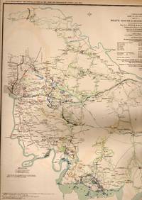
MAP: 5 Section Maps including White House to Harrison's Landing, Virginia; Seigne of Yorkstown, Williamsburg to White House, and 2 of Mulberry Island, Virginia
by United States War Department
- Used
- very good
- Paperback
- first
- Condition
- Very Good
- Seller
-
Hagerstown, Maryland, United States
Payment Methods Accepted
About This Item
Washington, D.C.: Government Printing Office, 1891. 1swt thus edition printing; Plate XIX....From the Atlas to Accompany the Official Records of the Union and Confederate Armies, 1861-1865..single sheet, lovely, and suitable for framing. 1st. Unbound. Very Good. Illus. by Colored Map. 18" x 29".
Reviews
(Log in or Create an Account first!)
Details
- Bookseller
- Dorley House Books
 (US)
(US)
- Bookseller's Inventory #
- 031849
- Title
- MAP: 5 Section Maps including White House to Harrison's Landing, Virginia; Seigne of Yorkstown, Williamsburg to White House, and 2 of Mulberry Island, Virginia
- Author
- United States War Department
- Illustrator
- Colored Map
- Format/Binding
- Paperback
- Book Condition
- Used - Very Good
- Edition
- 1st
- Publisher
- Government Printing Office
- Place of Publication
- Washington, D.C.
- Date Published
- 1891
- Keywords
- Civil War; Fort Fisher , North Carolina
- Size
- 18" x 29"
Terms of Sale
Dorley House Books
30 day return guarantee, with full refund including original shipping costs for up to 30 days after delivery if an item arrives misdescribed or damaged.
About the Seller
Dorley House Books
Biblio member since 2017
Hagerstown, Maryland
About Dorley House Books
We sell Rare, out-of-print, uncommon, & used BOOKS, PRINTS, MAPS, DOCUMENTS, AND EPHEMERA. We do not sell ebooks, print on demand, or other reproduced materials. Each item you see here is individually described and imaged. We welcome further inquiries, but prefer email rather than phone calls.
Glossary
Some terminology that may be used in this description includes:
Frequently asked questions

What is a first edition?
Even if you’re only peripherally aware of book collecting, you’ve doubtless heard the term, first edition, bandied about but you may still be in the dark as to what makes them such a big deal. Learn about first editions and why collectors value them here.

Beat Poet Michael McClure
From the fateful reading at Six-Gallery in 1955 to his novels, poetry, and stage productions, Michael McClure was right in the thick of the Beat Generation as it was born. See his books and art and learn more about the works of Michael McClure.