Description:
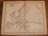
Edward Stanford, London, 1857. First Edition. Softcover. Good Condition/No Dust Jacket. Disbound single Sheet Map with horizontal centre fold from "The University Atlas of Classical and Modern Geography, including all the Recent Geographical Discoveries". Sheet is foxed and a little marked with darkened edges. Some wear and minor damage to edges and corners. Fold is split at both ends and a little fragile. Map covers Europe and includes: Iceland, British Isles, Scandinavia, Russia, France, Spain, Mediterranean, Black Sea, Central and Eastern Europe, Parts of Africa, Asia Minor and the Caspian Sea. Quantity Available: 1. Shipped Weight: under 1 kg. Pictures of this item not already displayed here available upon request. Inventory No: 45019044022. For international tracking please select Priority shipping service..
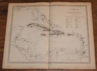
Map of the Antilles or West-India Islands - disbound sheet from 1857 "University Atlas by Edward Stanford, J. & C. Walker - 1857
by Edward Stanford, J. & C. Walker
Map of the Antilles or West-India Islands - disbound sheet from 1857 "University Atlas
by Edward Stanford, J. & C. Walker
- Used
- Paperback
- first
Edward Stanford, London, 1857. First Edition. Softcover. Good Condition/No Dust Jacket. Disbound single Sheet Map with vertical centre fold from "The University Atlas of Classical and Modern Geography, including all the Recent Geographical Discoveries". Sheet is lightly foxed with darkened edges. Some wear and damage to edges and corners. Fold is slightly split at both ends and is a little fragile. Map includes the West Indies or Caribbran, the Caribbean Sea, and parts of the Gulf of Mexico, Florida, Yucatan, Mexico, Guatimala, Venezuela, etc. Islands include Cuba, Haiti, Jamaica, Bahama Islands, Puerto Rico, Trinidad, Leeward and Windward Islands, etc. Coloured lines mark country boundaries and sea coasts are very pale blue. Quantity Available: 1. Shipped Weight: under 1 kg. Pictures of this item not already displayed here available upon request. Inventory No: 45019044043..
-
Bookseller
Bailgate Books Ltd
 (GB)
(GB)
- Format/Binding Softcover
- Book Condition Used - Good Condition
- Jacket Condition No Dust Jacket
- Quantity Available 1
- Edition First Edition
- Binding Paperback
- Publisher Edward Stanford
- Place of Publication London
- Date Published 1857
- Keywords BZDB4 NOISBN Maps; World History; Geology, geography, mineralogy, environment; South & Central America & the West Indies. Map of the Antilles or WestIndia Islands disbound sheet from 1857 University Atlas Edward Stanford J C Walker
More Photos
Map of Europe - disbound sheet from 1857 "University Atlas
by Edward Stanford, J. & C. Walker
- Used
- Paperback
- first
- Condition
- Used - Good Condition
- Jacket Condition
- No Dust Jacket
- Edition
- First Edition
- Binding
- Paperback
- Quantity Available
- 1
- Seller
-
Doncaster, Aberdeen, United Kingdom
- Item Price
-
$30.15
Show Details
Item Price
$30.15

More Photos
Map of Africa - disbound sheet from 1857 "University Atlas
by Edward Stanford, J. & C. Walker
- Used
- Paperback
- first
- Condition
- Used - Good Condition
- Jacket Condition
- No Dust Jacket
- Edition
- First Edition
- Binding
- Paperback
- Quantity Available
- 1
- Seller
-
Doncaster, Aberdeen, United Kingdom
- Item Price
-
$30.15
Show Details
Description:
Edward Stanford, London, 1857. First Edition. Softcover. Good Condition/No Dust Jacket. Disbound single Sheet Map with horizontal centre fold from "The University Atlas of Classical and Modern Geography, including all the Recent Geographical Discoveries". Sheet is lightly foxed with darkened edges. Some wear and damage to edges and corners. Sheet is a little marked. Fold is split at both ends and is a little fragile. Area covered includes: Africa Cape Colony, Nubia, Sahara, Soudan, Arabia (part), Red, Sea, Gibraltar Strait, Canaries, Cape Verde Islands, Maddagascar, etc. Some parts of Africa are marked 'Unexplored'. Sea coasts are coloured in very pale blue. Quantity Available: 1. Shipped Weight: under 1 kg. Pictures of this item not already displayed here available upon request. Inventory No: 45019044039. For international tracking please select Priority shipping service..
Item Price
$30.15
More Photos
Map of Spain and Portugal - disbound sheet from 1857 "University Atlas
by Edward Stanford, Philip Smith, J. & C. Walker
- Used
- Paperback
- first
- Condition
- Used - Good Condition
- Jacket Condition
- No Dust Jacket
- Edition
- First Edition
- Binding
- Paperback
- Quantity Available
- 1
- Seller
-
Doncaster, Aberdeen, United Kingdom
- Item Price
-
$30.15
Show Details
Description:
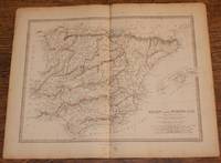
Edward Stanford, London, 1857. First Edition. Softcover. Good Condition/No Dust Jacket. Disbound single Sheet Map with vertical centre fold from "The University Atlas of Classical and Modern Geography, including all the Recent Geographical Discoveries". Sheet is a little foxed and marked with darkened edges. Some wear and minor damage to edges and corners. Fold is slightly split at both ends and a little fragile. Map covers the whole of mainland Spain and Portugal and includes the Balearic Islands (Iviza, Mallorca and Menorca), the Pyrenees, the Strait of Gibraltar and the Gulf of Lyon. Regions are differentiated with coloured lines. Quantity Available: 1. Shipped Weight: under 1 kg. Pictures of this item not already displayed here available upon request. Inventory No: 45019044029. For international tracking please select Priority shipping service..
Item Price
$30.15
More Photos
Map of the Greece - disbound sheet from 1857 "University Atlas
by Edward Stanford, J. & C. Walker
- Used
- Paperback
- first
- Condition
- Used - Good Condition
- Jacket Condition
- No Dust Jacket
- Edition
- First Edition
- Binding
- Paperback
- Quantity Available
- 1
- Seller
-
Doncaster, Aberdeen, United Kingdom
- Item Price
-
$30.15
Show Details
Description:
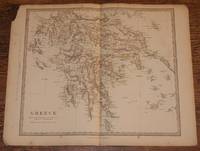
Edward Stanford, London, 1857. First Edition. Softcover. Good Condition/No Dust Jacket. Disbound single Sheet Map with vertical centre fold from "The University Atlas of Classical and Modern Geography, including all the Recent Geographical Discoveries". Sheet is a little foxed with darkened edges. Some wear and minor damage to edges and corners with loss to the top left corner in the margin only. Fold is slightly split at both ends and a little fragile. Map does not cover the whole of what is now Greece but centres on Morea. Includes Gulfs of Arta, Patras, Aegina, Lepanto, Volo, Arkadia, Koroni, Kolokythi and Nauplia. Not all Islands are included but the following are present; Lefkada, Kefalonia, Zante, Kithira or Kerigo, Skyro or Skiros, Andros, Milos, etc. Sea coasts are coloured in very pale blue. Quantity Available: 1. Shipped Weight: under 1 kg. Pictures of this item not already displayed here available upon request. Inventory No: 45019044034. For international tracking please…
Read More Item Price
$30.15

More Photos
Map of the Turkish Empire with Greece - disbound sheet from 1857 "University Atlas
by Edward Stanford, J. & C. Walker
- Used
- Paperback
- first
- Condition
- Used - Good Condition
- Jacket Condition
- No Dust Jacket
- Edition
- First Edition
- Binding
- Paperback
- Quantity Available
- 1
- Seller
-
Doncaster, Aberdeen, United Kingdom
- Item Price
-
$32.66
Show Details
Description:
Edward Stanford, London, 1857. First Edition. Softcover. Good Condition/No Dust Jacket. Full title: "The Turkish Empire in Europe and Asia with the Kingdom of Greece". Disbound single Sheet Map with vertical centre fold from "The University Atlas of Classical and Modern Geography, including all the Recent Geographical Discoveries". Sheet is a little foxed with darkened edges. Some wear and minor damage to edges and corners. Fold is slightly split at both ends and a little fragile. Map includes Greece, Turkey, Crete, Cyprus, the Black Sea and parts of Russia (now Ukraine), Hungary (now Romania), Bulgaria, Moldova, Syria, Georgia, Africa, Arabia, Persia and the Mediterranean and Caspian Seas, etc. Sea coasts are coloured in pale blue. Quantity Available: 1. Shipped Weight: under 1 kg. Pictures of this item not already displayed here available upon request. Inventory No: 45019044033. For international tracking please select Priority shipping service..
Item Price
$32.66
More Photos
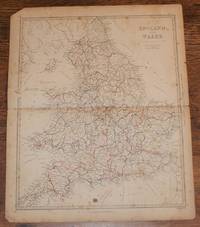
Map of England and Wales - disbound sheet from 1857 "University Atlas
by Edward Stanford, J. & C. Walker
- Used
- Paperback
- first
- Condition
- Used - Fair Condition
- Jacket Condition
- No Dust Jacket
- Edition
- First Edition
- Binding
- Paperback
- Quantity Available
- 1
- Seller
-
Doncaster, Aberdeen, United Kingdom
- Item Price
-
$32.66
Show Details
Description:
Edward Stanford, London, 1857. First Edition. Softcover. Fair Condition/No Dust Jacket. Disbound single Sheet Map with horizontal centre fold from "The University Atlas of Classical and Modern Geography, including all the Recent Geographical Discoveries". Sheet is foxed and marked with darkened edges. Some wear and damage to edges and corners. Fold is split at both ends and is a little fragile. Map includes railways, canals and rivers. County boundaries are marked in colour and sea coasts are very pale blue. Quantity Available: 1. Shipped Weight: under 1 kg. Pictures of this item not already displayed here available upon request. Inventory No: 45019044047. For international tracking please select Priority shipping service..
Item Price
$32.66
More Photos
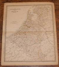
Map of the Netherlands and Belguim (De Nederlanden & La Belgique) - disbound sheet from 1857 "University Atlas
by Edward Stanford, J. & C. Walker
- Used
- Paperback
- first
- Condition
- Used - Good Condition
- Jacket Condition
- No Dust Jacket
- Edition
- First Edition
- Binding
- Paperback
- Quantity Available
- 1
- Seller
-
Doncaster, Aberdeen, United Kingdom
- Item Price
-
$32.66
Show Details
Description:
Edward Stanford, London, 1857. First Edition. Softcover. Good Condition/No Dust Jacket. Disbound single Sheet Map with horizontal centre fold from "The University Atlas of Classical and Modern Geography, including all the Recent Geographical Discoveries". Sheet is a little foxed with slightly darkened edges. Some wear and minor damage to edges and corners. Fold is split at both ends and a little fragile. The Netherlands are delineated in yellow and Belgium in Pink, boundaries mark both the Kingdoms and the Principalities. Parts of boardering France, Hannover and Prussia are present. Coast with North Sea is marked in pale blue. Quantity Available: 1. Shipped Weight: under 1 kg. Pictures of this item not already displayed here available upon request. Inventory No: 45019044024. For international tracking please select Priority shipping service..
Item Price
$32.66
More Photos
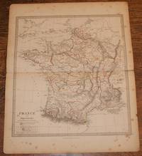
Map of France in Provinces - disbound sheet from 1857 "University Atlas
by Edward Stanford, T. Hewett Key, J. & C. Walker
- Used
- Paperback
- first
- Condition
- Used - Good Condition
- Jacket Condition
- No Dust Jacket
- Edition
- First Edition
- Binding
- Paperback
- Quantity Available
- 1
- Seller
-
Doncaster, Aberdeen, United Kingdom
- Item Price
-
$32.66
Show Details
Description:
Edward Stanford, London, 1857. First Edition. Softcover. Good Condition/No Dust Jacket. Disbound single Sheet Map with horizontal centre fold from "The University Atlas of Classical and Modern Geography, including all the Recent Geographical Discoveries". Sheet is a little foxed and marked with slightly darkened edges. Some wear and minor damage to edges and corners. Fold is split at both ends and a little fragile. Map covers the whole of France which is divided into Provinces. Provinces are outlined in various bright colours and coast lines in very pale blue. Quantity Available: 1. Shipped Weight: under 1 kg. Pictures of this item not already displayed here available upon request. Inventory No: 45019044026. For international tracking please select Priority shipping service..
Item Price
$32.66
More Photos
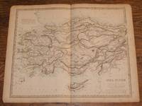
Map of Asia Minor (now Turkey) - disbound sheet from 1857 "University Atlas
by Edward Stanford, William Henry F. Plate, J. & C. Walker
- Used
- Paperback
- first
- Condition
- Used - Good Condition
- Jacket Condition
- No Dust Jacket
- Edition
- First Edition
- Binding
- Paperback
- Quantity Available
- 1
- Seller
-
Doncaster, Aberdeen, United Kingdom
- Item Price
-
$32.66
Show Details
Description:
Edward Stanford, London, 1857. First Edition. Softcover. Good Condition/No Dust Jacket. Disbound single Sheet Map with vertical centre fold from "The University Atlas of Classical and Modern Geography, including all the Recent Geographical Discoveries". Sheet is a little foxed with darkened edges. Some wear and minor damage to edges and corners. Fold is slightly split at both ends and is a little fragile. Area covered includes most of what is now Turkey: Anadoli, Umil, Karaman, Cyprus, the Sea of Marmara, parts of the Black and Mediterranean Seas and part of modern day Syria. Sea coasts are coloured in very pale blue and country borders are highlighted in colour. Quantity Available: 1. Shipped Weight: under 1 kg. Pictures of this item not already displayed here available upon request. Inventory No: 45019044036. For international tracking please select Priority shipping service..
Item Price
$32.66
More Photos
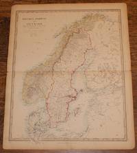
Map of Sweden, Norway and Denmark - disbound sheet from 1857 "University Atlas
by Edward Stanford, J. & C. Walker
- Used
- Paperback
- first
- Condition
- Used - Good Condition
- Jacket Condition
- No Dust Jacket
- Edition
- First Edition
- Binding
- Paperback
- Quantity Available
- 1
- Seller
-
Doncaster, Aberdeen, United Kingdom
- Item Price
-
$35.17
Show Details
Description:
Edward Stanford, London, 1857. First Edition. Softcover. Good Condition/No Dust Jacket. Disbound single Sheet Map with horizontal centre fold from "The University Atlas of Classical and Modern Geography, including all the Recent Geographical Discoveries". Sheet is a little foxed with darkened edges. Some wear and minor damage to edges and corners. Fold is slightly split at both ends and a little fragile. Full title is "Sweden, Norway and Denmark including the Baltic Sea & Russian Provinces Adjacent" which includes parts of what is now Finland, Estonia and Latvia (labeled as Russia). Bright coloured lines mark the boundaries of Sweden, Norway and Denmark, pale blue marks coast lines. Quantity Available: 1. Shipped Weight: under 1 kg. Pictures of this item not already displayed here available upon request. Inventory No: 45019044031. For international tracking please select Priority shipping service..
Item Price
$35.17