Map of Australia, Compiled from the Nautical Surveys, Made by Order of the Admiralty, And other Authentic Documents. By James Wyld. Geographer to the Queen. London. Published by James Wyld. Charing Cross East. 1844
by Wyld, James
- Used
- Condition
- See description
- Seller
-
Garrison, New York, United States
Payment Methods Accepted
About This Item
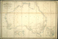
London: James Wyld, 1844. Dissected map mounted on linen. With notes on Mitchell's, Sturt's and Hume's explorations. National Library Bib ID 209675, although this edition not recorded in Tooley. The title refers to Wyld as "Geographer to the Queen", and the word "Queen" is a slightly different typeface; published from Charing Cross East, with 18 counties in NSW, which includes Queensland (Tooley lists 19 counties, but only 18 can be counted); 26 counties in Western Australia (called "New Holland"; Mount Hopeless added in South Australia, which is the only state with a border; inset of Van Diemens Land lower right, insert of the world lower left.
There is an advertisement for numerous Wyld maps on the verso of one panel starting with Post Roads of Europe, the Overland Route Map to India, Canada, Map of the Oregon District, Afghanistan, the Panjaub and River Indus, etc, and ending with Traveling Maps and Guides of every description. Verso of a fold has a tipped on advertising sheet for new maps with the cartographer to the Queen and HRH Prince Albert.
Steel engraving with period outline color. 82 x 55.5 cm. Some light overall foxing, 1.5" closed tear in bottom of map, repaired at the time of mounting on linen; should be accompanied by a slip case. Otherwise in very good condition.
Reviews
(Log in or Create an Account first!)
Details
- Bookseller
- Antipodean Books, Maps & Prints
 (US)
(US)
- Bookseller's Inventory #
- 14706
- Title
- Map of Australia, Compiled from the Nautical Surveys, Made by Order of the Admiralty, And other Authentic Documents. By James Wyld. Geographer to the Queen. London. Published by James Wyld. Charing Cross East. 1844
- Author
- Wyld, James
- Book Condition
- Used
- Quantity Available
- 1
- Publisher
- James Wyld
- Place of Publication
- London
- Date Published
- 1844
- Bookseller catalogs
- MAPS; AUSTRALIA; SOUTH AUSTRALIA;
Terms of Sale
Antipodean Books, Maps & Prints
30 day return guarantee, with full refund including shipping costs for up to 10 days after delivery if an item arrives mis-described or damaged.
About the Seller
Antipodean Books, Maps & Prints
Biblio member since 2009
Garrison, New York
About Antipodean Books, Maps & Prints
Booksellers for over 40 years, members of prominent trade associations (ABAA, ILAB, ANZAAB, IMCOS, ANZMS, PBFA). We are located at Garrison NY, a stone's throw from the Metro North Hudson line train, just over 1 hr. from NYC on the banks of the Hudson River. Books, maps, prints & ephemera bought & sold.
Glossary
Some terminology that may be used in this description includes:
- Verso
- The page bound on the left side of a book, opposite to the recto page.
- New
- A new book is a book previously not circulated to a buyer. Although a new book is typically free of any faults or defects, "new"...
- Slip Case
- A protective sleeve, often made of decorative cardboard or leather which houses a book. It is open on one end, so as to allow...
This Book’s Categories

Signed vs. Inscribed
Know what you are getting into when purchasing rare books, and learn the difference between signed books and inscribed books.

RIP (Please) George Romero: Modern Master of Zombie Horror
George Romero co-wrote and directed Night of the Living Dead in 1968, a film that inspired the modern zombie craze and made an indelible mark on American cinema. Come this way, horror fan...