Description:
Harry v. Hofmann Verlag, Hamburg, 1963. Hardcover. Good. in x in x in. Oblong-shaped hardcover. Light speckling and slight yellowing to the endpages and the title page. Book is gift-inscribed by 9 people to the prev. owner with the message: ""With our best thanks to our Community Chairman From your Bradford Jet(slightly unreadable?) Group 1963.""
Map. Cercle de Haut Rhin. Suivant les Nouvelles Observations de Mess.rs. de l’Academie Royale des Sciences etc. Augmentees de Nouveau. by van der Aa, Pieter
by van der Aa, Pieter

Map. Cercle de Haut Rhin. Suivant les Nouvelles Observations de Mess.rs. de l’Academie Royale des Sciences etc. Augmentees de Nouveau.
by van der Aa, Pieter
- Used
- very good
Leiden, 1729. From Abraham Du Bois, La Geographie Moderne, Naturelle, Historique & Politique dans une Methode Nouvelle.... Sheet (26cm x 40cm), image (22.5 cm x 30cm); decorative title cartouche at upper left with city and river scenes, conjoined cornucopias; ample lateral, good top and bottom margins. The map depicts a portion of the region of the upper Rhine from the confluence of the Rhine and the Main at Mayence (Mainz), west to the Nahe at Rudesheim, and then north to the entrance of the Moselle at Coblentz. The northern watershed of the River Main (Mein) is shown in some detail, as is the watershed of the Weser to the north, formed by the confluence of the Fulda and Werra. Cities and political divisions typical of the region in the 18th century are also shown in some detail. The copperplate engraving is dark and clear. Generally, an attractive map of Riesling country.
-
Bookseller
Independent bookstores
 (CA)
(CA)
- Book Condition Used - Very Good
- Quantity Available 1
Europa um 1700: 53 Kupferstich- Reproduktionen aus der Galerie agreable von 1729
by van der Aa, Pieter
- Used
- good
- Hardcover
- Condition
- Used - Good
- Binding
- Hardcover
- Quantity Available
- 1
- Seller
-
State College, Pennsylvania, United States
- Item Price
-
$20.00
Show Details
Item Price
$20.00
Europa um 1700. 53 Kupferstich-Reproduktionen aus der Galerie agreable von 1729.
by van der Aa, Pieter (Hrsg.)
- Used
- Hardcover
- Condition
- Used - gebraucht, gut Einband leicht lichtrandig und altersfleckig, innen sehr gut
- Binding
- Hardcover
- Quantity Available
- 1
- Seller
-
Oldenbüttel, Germany
- Item Price
-
$10.41
Show Details
Description:
Hamburg-Hamm , H. v. Hofmann Verlag,, 1963. hardcover. gebraucht, gut Einband leicht lichtrandig und altersfleckig, innen sehr gut.
Item Price
$10.41

Stock Photo: Cover May Be Different
De Doorlugtige Scheeps-togten Der Portugysen Na Oost-indiën, Mitsgaders De Voornaamste Gedeeltens Van Africa En De Roode-zee ...... (Dutch Edition)
by João de Barros, Johan Lodewyk Gottfried (Creator), Pieter van der Aa (Creator)
- Used
- good
- Paperback
- Condition
- Used - Good
- Binding
- Paperback
- ISBN 13
- 9781274646323
- ISBN 10
- 1274646324
- Quantity Available
- 1
- Seller
-
HOUSTON, Texas, United States
- Item Price
-
$36.34
Show Details
Description:
Nabu Press, 2012-02-06. Paperback. Good.
Item Price
$36.34
Europäische Städte-Ansichten um 1700. 53 Kupferstich Reproduktionen aus der Galerie agreable des Pieter von der Aa
by Aa, Pieter van der
- Used
- Hardcover
- Condition
- Used - Cloth binding, 23 x 30 cm cm, 106 pp. Ills.: zwart/wit illustraties. Hap uit schutblad. Fraaie paginagrote afbeeldingen van vele
- Binding
- Hardcover
- Quantity Available
- 1
- Seller
-
Kloosterburen, Netherlands
- Item Price
-
$8.63
Show Details
Description:
Hamburg: Hofmann, 1963. Cloth binding, 23 x 30 cm cm, 106 pp. Ills.: zwart/wit illustraties. Hap uit schutblad. Fraaie paginagrote afbeeldingen van vele steden, waaronder bijv. Leiden en Leeuwarden. Cond.: goed / good. .
Item Price
$8.63

Europäische Städte-Ansichten um 1700.: Kupferstich-Reproduktionen aus der Galérie Agréable.
by Aa, Pieter van der
- Used
- Condition
- Used
- Quantity Available
- 1
- Seller
-
Berne, Switzerland
- Item Price
-
$22.65
Show Details
Description:
1963 . Hamburg-Hamm: v. Hofmann 1963. quer-8°. 106 S., durchgehend Illustrationen, Pappband Schutzumschlag mit Randläsuren und kleinen Einrissen, angestaubt und wenig befleckt; Vorsatz wenig befleckt; leicht gebräunt)
Item Price
$22.65

Antiguo Grabado - Old Engraving : Habits and Croix des Chevaliers Espagnols. (1715).
by PIETER, VAN DER AA
- Used
- Paperback
- Condition
- Used - Muy buen estado.
- Binding
- Paperback
- Quantity Available
- 1
- Seller
-
Carcaixent, Valencia, Spain
- Item Price
-
$33.71
Show Details
Description:
1715. Muy buen estado.. 1 lámina 16x13cm (lámina) Encuadernada en paspartú. Grabado en 1715 por Pieter van der Aa de la obra Les delices de l´Espagne et du Portugal, la más ilustrada de la época. Soporte de cartón.
Item Price
$33.71

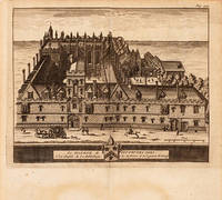
Le College de New-Inn à Oxford.
by AA, Pieter van der
- Used
- Condition
- Used
- Quantity Available
- 1
- Seller
-
London, United Kingdom
- Item Price
-
$63.00
Show Details
Description:
Leiden: , c1707. New Inn Hall was originally founded in the thirteenth century, it later became a part of Balliol College. This delightful octavo engraving is based on the earlier and larger work entitled 'Oxonia Illustrata' (1695) by the English baroque engraver, draughtsman and painter; David Loggan. It was produced by James Beeverall, in the 'Les Delices de la Grande Bretagne' and published in Leiden by Pieter van der Aa. Size: 155 x 175 mm. Copperplate engraving. Mild toning, but in good condition.
Item Price
$63.00

Le Collège de S. Mary-Hall à Oxford.
by AA, Pieter van der
- Used
- Condition
- Used
- Quantity Available
- 1
- Seller
-
London, United Kingdom
- Item Price
-
$63.00
Show Details
Description:
Leiden: , c1707. St. Mary Hall was an academic hall, and was closely associated with Oriel College since the early part of the fourteenth century. This delightful octavo engraving is based on the earlier, larger work entitled 'Oxonia Illustrata' (1695) by the English baroque engraver, draughtsman and painter; David Loggan. It was produced by James Beeverall in the 'Les Delices de la Grande Bretagne' and published in Leiden by Pieter van der Aa. Size: 160 x 170 mm. Copperplate engraving. Very good condition.
Item Price
$63.00
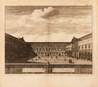
Partie du College de S. Jean Baptiste.: (St. John's College).
by AA, Pieter van der
- Used
- Condition
- Used
- Quantity Available
- 1
- Seller
-
London, United Kingdom
- Item Price
-
$63.00
Show Details
Description:
Leiden: , c1707. An internal view of St. John's College - one of Oxford's richest colleges, founded by Thomas White, a wealthy merchant in 1555. This delightful octavo engraving is based on the earlier and larger work entitled 'Oxonia Illustrata' (1695) by the English baroque engraver, draughtsman and painter; David Loggan. It was produced by James Beeverall, in the 'Les Delices de la Grande Bretagne' and published in Leiden by Pieter van der Aa. Size: 155 x 175 mm. Copperplate engraving. Slightly toned, but in good condition.
Item Price
$63.00
Le College de Toutes les Ames.: (All Souls College)
by AA, Pieter van der
- Used
- Condition
- Used
- Quantity Available
- 1
- Seller
-
London, United Kingdom
- Item Price
-
$63.00
Show Details
Description:
Leiden: , c1707. All Souls College is one of the wealthier Oxford colleges, founded in the fifteenth century by King Henry VI. This delightful octavo engraving is based on the earlier and larger work entitled 'Oxonia Illustrata' (1695) by the English baroque engraver, draughtsman and painter; David Loggan. It was produced by James Beeverall, in the 'Les Delices de la Grande Bretagne' and published in Leiden by Pieter van der Aa. Size: 155 x 175 mm. Copperplate engraving. Mild toning, in good condition.
Item Price
$63.00