
Click for full-size.
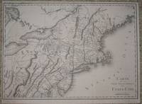
(Map / Chart of New England- USA): Carte De La Partie Septentrionale Des Etats_Unis
by Tardieu, P. F
- Used
- Condition
- See description
- Seller
-
Crozet, Virginia, United States
Payment Methods Accepted
About This Item
Paris: Tardieu, 1802. VG+, b&w as issued. Scarce, detailed, with entire New England coastline from Delaware northward to Pasamaquody Bay, and streching westward to the eastern halves of Lake Huron and Lake Erie. Includes listings for Great and Little Egg Harbor, Martha's Vineyard, Cape Cod. A very handsome map with numerous waterway and topographical details, with place names of all major cities of the times, on excellent paper . The Tardieu's were a family of mapmakers from the mid-18th to early 19th century. Left margin a bit close. Measuring 14x19.75 inches (36x50cm). .
Reviews
(Log in or Create an Account first!)
Details
- Bookseller
- The Prime Meridian: Antique Maps & Books
 (US)
(US)
- Bookseller's Inventory #
- 1991
- Title
- (Map / Chart of New England- USA): Carte De La Partie Septentrionale Des Etats_Unis
- Author
- Tardieu, P. F
- Book Condition
- Used
- Publisher
- Tardieu
- Place of Publication
- Paris
- Date Published
- 1802
- Keywords
- Maps, Map, New England, Cartography, Geography, Long Island, Long Island Sound, Nantucket, Cape Cod, Martha's Vineyard, Geography, New York, Maine, Canada, Massachusetts, Connecticut, Rhode Island, Coastal Chart
- Bookseller catalogs
- B. Maps--US & N. America;
Terms of Sale
The Prime Meridian: Antique Maps & Books
We accept cash, check, money order, American Express, Visa, Discover and Mastercard. Virginia sales tax will be added to instate purchases. Shipping charges are billed at cost, and will be added to the invoice. We usually include insurance with the postage, and as a result we do not routinely use media mail. If you wish the book sent via the latter route, it would be at your risk. For heavy items, there may be extra shipping charges. Any item maybe returned (postpaid and carefully packed by purchaser) within 7 days of receipt. We do not generally refund postal charges. Please notify us before sending a return. We do not share customer information with any outside sources; all details and addresses are confidential.
About the Seller
The Prime Meridian: Antique Maps & Books
Biblio member since 2005
Crozet, Virginia
About The Prime Meridian: Antique Maps & Books
The Prime Meridian: Antique Maps & Books is owned and operated by Joel & Deborah Kovarsky. We first opened in 1998, but have had a decades-old interest in old maps, books, and paper, stemming from a comparable long-standing interest in how knowledge is used. Our business is run via the internet. We do not run an open shop, however we do welcome visitors by appointment only. Before attempting a visit, please contact us. We are a specialty business, dealing in antiquarian maps and related books (atlases, history of cartography, selected reference books, etc.). Please feel free to contact us for specific inquiries.
Glossary
Some terminology that may be used in this description includes:
- New
- A new book is a book previously not circulated to a buyer. Although a new book is typically free of any faults or defects, "new"...

Collecting Disneyana
Welcome to the wonderful world of collecting Walt Disney! From letters signed by Disney himself to classic children’s books or ephemera, be sure to check out some of the collectible Walt Disney books on Biblio!

Collectible Christmas Cards
Many of us love giving and receiving holiday cards - but did you know many of them are highly collectible? Whether signed by famous authors or just beautiful to look at, these collectible Christmas cards are sure to put a twinkle in your eye.