
Click for full-size.
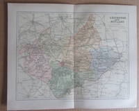
MAP OF LEICESTERSHIRE AND RUTLAND- 1894
by J.H.F. Brabner
- Used
- very good
- Paperback
- Condition
- Very Good
- Seller
-
South Kelsey, Lincolnshire, United Kingdom
Payment Methods Accepted
About This Item
United Kingdom: William Mackenzie. This is the 1894 coloured maps of Leicestershire and Rutland taken from 'The comprehensive gazetteer of England and Wales' edited by J.H.F. Brabner, published in 1894. Each map measures 32 x 25 cms and has a centre fold . Very Good. Soft cover. 1894.
Reviews
(Log in or Create an Account first!)
Details
- Bookseller
- Winghale Books
 (GB)
(GB)
- Bookseller's Inventory #
- 089484
- Title
- MAP OF LEICESTERSHIRE AND RUTLAND- 1894
- Author
- J.H.F. Brabner
- Format/Binding
- Soft cover
- Book Condition
- Used - Very Good
- Quantity Available
- 1
- Binding
- Paperback
- Publisher
- William Mackenzie
- Place of Publication
- United Kingdom
- Date Published
- 1894
Terms of Sale
Winghale Books
30 day return guarantee, with full refund including original shipping costs for up to 30 days after delivery if an item arrives misdescribed or damaged.
About the Seller
Winghale Books
Biblio member since 2013
South Kelsey, Lincolnshire
About Winghale Books
Internet Only. UK Bookseller we have been selling academic history books for over 20 years and although our stock is still mainly history we now cover other academic subject areas.

May the Fourth Be With You!
As the Star Wars franchise continues to grow, change, and churn out money-making film after film now under the control of Disney, we can bet that the desire to own Star Wars collectibles will also continue to grow. Check out our gallery of goodies from a galaxy far, far away...
Collecting Dr. Seuss
Whether you are into the pricey first editions or interesting Seussiana ephemera, this is a good starting point for building a book collection based on Dr. Seuss.