Description:
Philadelphia: Mitchell, S. Augustus, 1867. 13 1/2 x 10 3/4. Good condition with expertly repaired marginal tears. All repairs are with conservation mending tape.. This antique lithograph was printed and hand colored just two years after the Civil War ended. The area is one of Islam's most sacred holding almost all of the holy sites. This is an important map. for the era of the Ottoman Empire.
Map of Persia, Turkey in Asia, Afghanistan, Beloochistan by Mitchell, S. Augustus, Jr - 1860
by Mitchell, S. Augustus, Jr
Similar copies are shown below.
Similar copies are shown to the right.

Map of Persia, Turkey in Asia, Afghanistan, Beloochistan
by Mitchell, S. Augustus, Jr
- Used
- very good
Philadelphia: S. Augustus Mitchell, Jr., 1860. Book. Very Good. No Binding. 12 3/4" x 15 1/2" (image including 3/4" decorative floral border is 10 1/2" by 13 1/4") with 3 1/2" x 3" inset map of Palestine or the Hold Land. Scale appears to be 1"= ca.220 miles. Hand colored. Borders lightly browning but otherwise in very good condition. S. Augustus Mitchell, Jr. took over the map publishing firm of his father, Samuel Augustus Mitchell, in 1860 and parlayed it into one of the most prolific American map publishing firms in the country..
-
Bookseller
James Hurley, Books
 (US)
(US)
- Book Condition Used - Very Good
- Publisher S. Augustus Mitchell, Jr.
- Place of Publication Philadelphia
- Date Published 1860
- Keywords Maps Cartography Persia Afghanistan Beloochistan Asiatic Turkey Middle East S. Augustus Mitchell, Jr. American Map Makers Publishers
We have 3 copies available starting at $45.00.

Map of Persia, Turkey in Asia, Afghanistan, Beloochistan
by Mitchell, S. Augustus
- Used
- Condition
- Used - Good condition with expertly repaired marginal tears. All repairs are with conservation mending tape.
- Quantity Available
- 1
- Seller
-
Franklin, Tennessee, United States
- Item Price
-
$45.00
Show Details
Item Price
$45.00

Map of Persia Turkey in Asia, Afghanistan, Beloochistan
by S. Augustus Mitchell
- Used
- very good
- Condition
- Used - Very good
- Quantity Available
- 1
- Seller
-
Franklin, Tennessee, United States
- Item Price
-
$45.00
Show Details
Description:
Philadelphia: S. Augustus Mitchell, 1867. 13 1/2 x 10 3/4 inches. Very good. This map runs from Cairo in the west to the Indus River in the East. Comprehensive is an understatement. The Independent Tartarry bounds the map on the north. Overall this composition covers a significant part of a Eurocentric world. There is an inset map of Palestine and the Holy Land.
Item Price
$45.00
More Photos
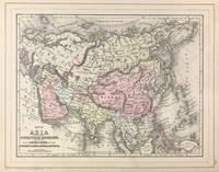
Map of Asia Showing its Gt. Political Divisions, and also the Various Routes of Travel Between London & India, China & Japan &c. [verso with] Map of Persia, Arabia, Turkey in Asia, Afghanistan, Beloochistan
by Mitchell, S. Augustus, Jr
- Used
- Condition
- Used - Very good, light soiling, primarily to margins.
- Quantity Available
- 1
- Seller
-
East Jewett, New York, United States
- Item Price
-
$50.00
Show Details
Description:
[Philadelphia]: [W.M. Bradley], 1886. Very good, light soiling, primarily to margins.. Hand colored map. Plate 115: Map of Asia Showing its Gt. Political Divisions, and also the Various Routes of Travel Between London & India, China & Japan &c, constructed & engraved by W. Williams, Philadelphia. Copyright by S. Augustus Mitchell 1884. 13.5 x 10.5 inches. [On verso] Plate 116: Map of Persia, Arabia, Turkey in Asia, Afghanistan, Beloochistan. Copyright by S. Augustus Mitchell 1884. 13.5 x 10.5 inches. From: Mitchell's New General Atlas, Containing Maps Of The Various Countries Of The World, Plans Of Cities, Etc., Embraced In Ninety-Three Quarto Maps, Forming A Series Of One Hundred and Forty-seven Maps and Plans, Together With Valuable Statistical Tables. Also, A List Of Post-Offices Of The United States And Territories, And Also Census Of 1880 For States, Territories And Counties, Also Of Cities Of Over 10,000 Inhabitants. Philadelphia: Published By Wm. M. Bradley & Bro., No. 1026 Arch Street. 1886.
Item Price
$50.00