Description:
Paris: Jaillot, 1695. VG, with only flaw some dampstaining at lower margin with expert verso paper reinforcement, not affecting main image (would mat well). Centerfold as issued; hand-colored. A very uncommon and attractive plate, with a small walled city view (birds-eye) of Vienna, with all surrounding villages (castles) marked. A nice image of the Danube is central here. Jaillot was originally a sculptor (see Moreland & Bannister: Antique Maps). The copperplate image is 18x25.5 inches. .
(Map of Southwestern Africa): Typus orarum maritimarum Guineae, Manicongo & Angolae ultra Promentorium Bonae spei by Linschoten, Jan (John) van Huygen - 1596
by Linschoten, Jan (John) van Huygen
(Map of Southwestern Africa): Typus orarum maritimarum Guineae, Manicongo & Angolae ultra Promentorium Bonae spei
by Linschoten, Jan (John) van Huygen
- Used
Amsterdam, 1596. A highly decorative map of the southwestern coast of Africa. Overall very good, with early color. Some restoration most evident central verso, few professional wormhole repairs with margins reinforced verso. The map was engraved by Florent van Langren, and the first Dutch edition of Linschoten's "Itinerario..." was published by Cornelis Claesz in 1596. There are coastal views of the islands of Ascension and St. Helena within a strapwork cartouche at the bottom of the map. This is just the western sheet. The image measures 15.25 x 20.5 inches (39 x 52 cm). Two compass roses, decorative script and sailing ships. Coastal town names go inland, in the style of earlier portolan charts..
-
Bookseller
The Prime Meridian: Antique Maps & Books
 (US)
(US)
- Book Condition Used
- Place of Publication Amsterdam
- Date Published 1596
- Keywords Africa, History of Cartography, Maps, Voyages

(Map / Chart- Environs of Vienna, Austria): Plan de la Ville De Vienne en Austriche et Ses Environs
by Jaillot, Alexis-Hubert
- Used
- Condition
- Used
- Binding
- Unknown
- Quantity Available
- 1
- Seller
-
Crozet, Virginia, United States
- Item Price
-
$595.00
Show Details
Item Price
$595.00

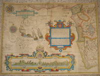
(Map of Holy Land- Canaan): Canaan
by Speed (Speede), John
- Used
- first
- Condition
- Used
- Binding
- Unknown
- Quantity Available
- 1
- Seller
-
Crozet, Virginia, United States
- Item Price
-
$1,495.00
Show Details
Description:
London: Christopher Browne (at the Globe near the West End of St. Pauls Church), 1695. Good, hand colored outlines, This is the Christopher Browne imprint (see Roderick M. Barron's description in his catalogue 33 as to the recent discovery of this imprint, separate from the more commonly reported Bassett and Chiswell 1676 plate), which may be more common than initially thought. Browne published a bit later, and had purchased the Bassett and Chiswell plates, then changed the name on a few of those (of which this plate was one; very few survive), and the date here is approximate. This is a striking image with Jerusalem inset, newly updated and published in the 1676 edition (date approximate) of Speed's " A Prospect of the Most Famous Parts of the World". There is some general browning, with some professional restorations at folds (virtually no image loss), mild upper margin staining (mostly in blank areas) and backed with Japon paper. A custom case was made for this map, after…
Read More Item Price
$1,495.00

(City / Town Plan - Toledo, Spain): Toletum
by Braun, Georg and Hogenberg, Franz
- Used
- Condition
- Used
- Binding
- Unknown
- Quantity Available
- 1
- Seller
-
Crozet, Virginia, United States
- Item Price
-
$1,800.00
Show Details
Description:
Braun & Hogenberg, 1598. Near fine, early color, latin edition (applicable text verso). Very decorative town plan of Toledo, Spain from this edition of the famous city atlas. Cherubim, palace, temple all present as separate images. These plans are well-known to collectors, and this particular item is increasingly uncommon. The full atlas was published in 6 volumes, in various editions, from 1572-1617. It was a collaborative work between many artists, engravers and cartographers (for a nice discussion of the history of this atlas, see Goss's THE MAPMAKERS ART, pp. 260-5). The map image measures 12.75x20 inches..
Item Price
$1,800.00

(Map of Caspian Sea & Environs): Nova et Accuratissima Maris Caspii...petri Alexii Filii. Magni Russorum Emper
by Seutter, GM
- Used
- Condition
- Used
- Binding
- Unknown
- Quantity Available
- 1
- Seller
-
Crozet, Virginia, United States
- Item Price
-
$550.00
Show Details
Description:
Augsburg: Seutter, 1740. VG+, copperplate engraving with original hand coloring (color similar to Homann, with whom Seutter apprenticed before going out on his own in about 1707). There is minimal right marginal soling, but the image and color are exceptionally bright. Decorative cartouche, as usual, probably an allegorical representation of imperial Russia. The map measures 19.25x22.5 inches. .
Item Price
$550.00

(Map of Pennsylvania): Geographical, Statistical, and Historical Map of Pennsylvania
by Carey & Lea (engr.by Young & Delleker)
- Used
- Hardcover
- first
- Condition
- Used
- Binding
- Hardcover
- Quantity Available
- 1
- Seller
-
Crozet, Virginia, United States
- Item Price
-
$400.00
Show Details
Description:
Philadelphia (Chestnut Street), 1822: HC Carey and I Lea, 1822. VG due to some minimal dampstaining most evident left upper corner, and minimally crossing neatline. The color portion of the map shows no significant visual effects from the stains. The original hand-colored image is clear and bright, with the surrounding letterpre ss text detailing aspects of population, climate, commerce, religion, government. There is a nice general historical sketch (in a separate page of original text, included here-- "Appendix to No. 18") in the letterpress. From the first edition "A Complete Historical, Chronological, and Geographical American Atlas...", which was also the first American atlas with letterpress printing on the map. This is a nice map, but for the defects described. The map image is 45x31cm; the entire image is 52.5x42cm..
Item Price
$400.00

(Map / Chart- Ottoman, Turkish Empire): Estats De L'Empire Du Grand Seigneur Des Turcs, En Europe, En Asie, et En Afrique, Divise En Touts Ses Beglerbeglicz, Ou Gouvernments
by Jaillot, Alexis-Hubert
- Used
- Condition
- Used
- Binding
- Unknown
- Quantity Available
- 1
- Seller
-
Crozet, Virginia, United States
- Item Price
-
$1,200.00
Show Details
Description:
Paris: H. Jaillot, 1695. VG, heavy paper, hand colored, decorative cartouche, inset of southern mediterranean / Algerian coast. A striking image, after Sanson and copied by several later cartographers. The above date is approximate, although clearly printed with the 5 scales indicated on the map.. Some browning and chipping of lower margin, not crossing neatline and easily covered by matting. This depicts the Ottoman (Turkish) Empire at the time, with its reaches through Asia, Europe and Africa. Includes environs of Mediterranean, Black, Red and Caspian Seas, with the "Golfe D'Ormus" at the western edge of the map. Includes details of Mediterranean with Cyprus, Rhodes, Candie, Sicily, Sardinia and Corsica, and much more. This is a very uncommon map, with the image measuring 18x25 inches (centerfold as issued)..
Item Price
$1,200.00
(City / Town Plan - Toledo, Spain): Toletum
by Braun, Georg and Hogenberg, Franz
- Used
- Condition
- Used
- Binding
- Unknown
- Quantity Available
- 1
- Seller
-
Crozet, Virginia, United States
- Item Price
-
$1,800.00
Show Details
Description:
Braun & Hogenberg, 1598. Near fine, early color, latin edition (applicable text verso). Very decorative town plan of Toledo, Spain from this edition of the famous city atlas. Cherubim, palace, temple all present as separate images. These plans are well-known to collectors, and this particular item is increasingly uncommon. The full atlas was published in 6 volumes, in various editions, from 1572-1617. It was a collaborative work between many artists, engravers and cartographers (for a nice discussion of the history of this atlas, see Goss's THE MAPMAKERS ART, pp. 260-5). The map image measures 12.75x20 inches..
Item Price
$1,800.00
(Map of Caspian Sea & Environs): Nova et Accuratissima Maris Caspii...petri Alexii Filii. Magni Russorum Emper
by Seutter, GM
- Used
- Condition
- Used
- Binding
- Unknown
- Quantity Available
- 1
- Seller
-
Crozet, Virginia, United States
- Item Price
-
$550.00
Show Details
Description:
Augsburg: Seutter, 1740. VG+, copperplate engraving with original hand coloring (color similar to Homann, with whom Seutter apprenticed before going out on his own in about 1707). There is minimal right marginal soling, but the image and color are exceptionally bright. Decorative cartouche, as usual, probably an allegorical representation of imperial Russia. The map measures 19.25x22.5 inches. .
Item Price
$550.00
(Map of Pennsylvania): Geographical, Statistical, and Historical Map of Pennsylvania
by Carey & Lea (engr.by Young & Delleker)
- Used
- Hardcover
- first
- Condition
- Used
- Binding
- Hardcover
- Quantity Available
- 1
- Seller
-
Crozet, Virginia, United States
- Item Price
-
$400.00
Show Details
Description:
Philadelphia (Chestnut Street), 1822: HC Carey and I Lea, 1822. VG due to some minimal dampstaining most evident left upper corner, and minimally crossing neatline. The color portion of the map shows no significant visual effects from the stains. The original hand-colored image is clear and bright, with the surrounding letterpre ss text detailing aspects of population, climate, commerce, religion, government. There is a nice general historical sketch (in a separate page of original text, included here-- "Appendix to No. 18") in the letterpress. From the first edition "A Complete Historical, Chronological, and Geographical American Atlas...", which was also the first American atlas with letterpress printing on the map. This is a nice map, but for the defects described. The map image is 45x31cm; the entire image is 52.5x42cm..
Item Price
$400.00

(Map of Eastern America and Atlantic Ocean): Carte De L'Ocean Occidental et Partie De L'Amerique Septentrionale..Charlevoix..fait En 1720
by Bellin, Jacques Nicolas
- Used
- Condition
- Used
- Binding
- Unknown
- Quantity Available
- 1
- Seller
-
Crozet, Virginia, United States
- Item Price
-
$485.00
Show Details
Description:
Paris: Ganeau, 1744. Excellent condition, strong impression, b&w engraved copperplate from Tome III of the 4to, 1744 edition of Charlevoix's "Histoire de la Nouvelle France" (Journal D'un Voyage...). The image is 9.5 x 14.5 inches, with folds as issued. This image has the full eastern USA, including Louisiane, north to Newfoundland, most of the Great Lakes, teh Atlantic Ocean, Acores, and east to the western coasts of Africa, Spain, France and British Isles. It is quite attractive, and not often seen for sale in this early state..
Item Price
$485.00

Stock Photo: Cover May Be Different
The Voyage of John Huyghen van Linschoten to the East Indies: The first book, containing his description of the East. Volume 1
by Jan Huygen van Linschoten
- Used
- Paperback
- Condition
- Used: Good
- Binding
- Paperback
- ISBN 13
- 9781402195075
- ISBN 10
- 1402195079
- Quantity Available
- 1
- Seller
-
HOUSTON, Texas, United States
- Item Price
-
$12.88
Show Details
Description:
Adamant Media Corporation, 2001-10-05. Paperback. Used: Good.
Item Price
$12.88

The Voyage of John Huyghen van Linschoten to the East Indies: The first book, containing his description of the East. Volume 1
by Jan Huygen van Linschoten
- Used
- very good
- Paperback
- Condition
- Used - Very Good
- Binding
- Paperback
- ISBN 13
- 9781402195075
- ISBN 10
- 1402195079
- Quantity Available
- 1
- Seller
-
GORING BY SEA, West Sussex, United Kingdom
- Item Price
-
$10.31
Show Details
Description:
Paperback. Very Good.
Item Price
$10.31
Stock Photo: Cover May Be Different
The Voyage of John Huyghen van Linschoten to the East Indies: The first book, containing his description of the East. Volume 1
by Jan Huygen van Linschoten
- Used
- Paperback
- Condition
- Used:Good
- Binding
- Paperback
- ISBN 13
- 9781402195075
- ISBN 10
- 1402195079
- Quantity Available
- 1
- Seller
-
HOUSTON, Texas, United States
- Item Price
-
$23.39
Show Details
Description:
Adamant Media Corporation, 2001-10-05. Paperback. Used:Good.
Item Price
$23.39

Stock Photo: Cover May Be Different
The Last Fight Of The Revenge At Sea: Under The Command Of Richard Grenville, On September 10-11, 1591 (1871)
by Walter Raleigh; Gervase Markham; Jan Huygen Van Linschoten
- Used
- good
- Paperback
- Condition
- Used - Good
- Binding
- Paperback
- ISBN 13
- 9781104660765
- ISBN 10
- 1104660768
- Quantity Available
- 1
- Seller
-
HOUSTON, Texas, United States
- Item Price
-
$24.64
Show Details
Description:
Kessinger Publishing, LLC, 2009-06-13. Paperback. Good.
Item Price
$24.64
Stock Photo: Cover May Be Different
The Last Fight Of The Revenge At Sea: Under The Command Of Richard Grenville, On September 10-11, 1591 (1871)
by Walter Raleigh, Gervase Markham, Jan Huygen Van Linschoten
- Used
- Paperback
- Condition
- Used:Good
- Binding
- Paperback
- ISBN 13
- 9781104660765
- ISBN 10
- 1104660768
- Quantity Available
- 1
- Seller
-
HOUSTON, Texas, United States
- Item Price
-
$24.64
Show Details
Description:
Kessinger Publishing, LLC, 2009-06-13. Paperback. Used:Good.
Item Price
$24.64

Stock Photo: Cover May Be Different
Journael van de derthien-jarighe reyse, te water en te lande, gedaen door Jan Huygen van Linschooten, na Oost-Indienh: inhoudende de beschryvinge der ... inwoonders en Portugesen ... (Dutch Edition)
by Jan Huygen van Linschoten (Creator)
- Used
- good
- Paperback
- Condition
- Used - Good
- Binding
- Paperback
- ISBN 13
- 9781275701175
- ISBN 10
- 1275701175
- Quantity Available
- 1
- Seller
-
HOUSTON, Texas, United States
- Item Price
-
$32.18
Show Details
Description:
Gale, Sabin Americana, 2012-02-22. Paperback. Good.
Item Price
$32.18

Stock Photo: Cover May Be Different
Early Travels In India: First Series, Comprising Purchas's Pilgrimage, And The Travels Of Van Linschoten (1864)
by Samuel Purchas, Jan Huygen Van Linschoten, James Talboys Wheeler (Foreword)
- Used
- good
- Paperback
- Condition
- Used - Good
- Binding
- Paperback
- ISBN 13
- 9781165425365
- ISBN 10
- 116542536X
- Quantity Available
- 1
- Seller
-
HOUSTON, Texas, United States
- Item Price
-
$37.63
Show Details
Description:
Kessinger Publishing, LLC, 2010-09-10. Paperback. Good.
Item Price
$37.63

Stock Photo: Cover May Be Different
Early Travels In India: First Series, Comprising Purchas's Pilgrimage, And The Travels Of Van Linschoten (1864)
by Samuel Purchas, Jan Huygen Van Linschoten, James Talboys Wheeler (Foreword)
- Used
- good
- Paperback
- Condition
- Used - Good
- Binding
- Paperback
- ISBN 13
- 9781104120047
- ISBN 10
- 1104120046
- Quantity Available
- 1
- Seller
-
HOUSTON, Texas, United States
- Item Price
-
$37.63
Show Details
Description:
Kessinger Publishing, LLC, 2009-03-04. Paperback. Good.
Item Price
$37.63

The Voyage Of John Huyghen Van Linschoten To The East Indies. From The Old English Translation Of 1598 [by W. Phillip] The First Book, Containing His Description Of The East; Volume 2
by Jan Huygen Van Linschoten
- New
- Paperback
- Condition
- New
- Binding
- Paperback
- ISBN 13
- 9781017836301
- ISBN 10
- 1017836302
- Quantity Available
- 10
- Seller
-
Southport, Merseyside, United Kingdom
- Item Price
-
$27.23
Show Details
Description:
Paperback / softback. New.
Item Price
$27.23
Itinerario, voyage, ofte schipvaert van Jan Huygen van Linschoten naer Oost ofte Portugaels Indien, 1579-1592, uitgegeven door prof. dr. H. Kern; 05
by Jan Huygen Van 1563-1611 Linschoten
- New
- Paperback
- Condition
- New
- Binding
- Paperback
- ISBN 13
- 9781016914390
- ISBN 10
- 1016914393
- Quantity Available
- 10
- Seller
-
Southport, Merseyside, United Kingdom
- Item Price
-
$30.98
Show Details
Description:
Paperback / softback. New.
Item Price
$30.98

More Photos
The Sky and the Forest
by Forester, C.S
- Used
- very good
- Hardcover
- first
- Condition
- Used - Very Good
- Jacket Condition
- Very Good
- Edition
- First Edition
- Binding
- Hardcover
- Quantity Available
- 1
- Seller
-
Salem, Oregon, United States
- Item Price
-
$34.89$20.93Save $13.96!
Show Details
Description:
C.S. Forester: The Sky and the Forest. Little, Brown and Company, Boston. Stated First Edition First Printing Thus August, 1948. Cover price $2.75. Used. VG BOOK/VG UNCLIPPED DUST JACKET. A story of a central Africa. By C.S. Forester, author of the Admiral Hornblower series.
Item Price
$34.89$20.93
Save $13.96
!
![Alaska and Klondike Region; [With inset of Klondike Region on the Upper Yukon detail] [From an...](https://d3525k1ryd2155.cloudfront.net/h/062/537/1339537062.0.m.jpg)
Alaska and Klondike Region; [With inset of Klondike Region on the Upper Yukon detail] [From an atlas, "Gazetteer of Alaska and Yukon Region " pp. 105 and 106]
by Miller, J. Martin
- Used
- very good
- Condition
- Used - Very Good
- Edition
- Unknown
- Quantity Available
- 1
- Seller
-
Sebastopol, California, United States
- Item Price
-
$39.00
Show Details
Description:
Chicago: J. Martin Miller, 1899. Unknown. Map. Very Good. [Map copyright 1899, printing date of Atlas later] [19.875x15.125in]; Colored map of Alaska with steamer routes from Portland and Seattle, insets of the Klondike Region on the Upper Yukon and Western portion of Aleutian Islands; On verso index of places and names with two large black and white images; Age toning to all edges, water stain marks on bottom, slight printing offset of colors, small chips and closed tears to lower edge;.
Item Price
$39.00

Zemepis Sveta - Monsunova Asie
by De La Blache, P. Vidal; Gallois, L
- Used
- Hardcover
- Condition
- Used - Very Good Condition
- Jacket Condition
- No Dust Jacket
- Binding
- Hardcover
- Quantity Available
- 1
- Seller
-
Oak Point, Texas, United States
- Item Price
-
$60.00
Show Details
Description:
Aventinum, Prague, Czechoslovakia, 1930. Hardcover. Very Good Condition/No Dust Jacket. Text entirely in Czech. Geography book on Asia with numerous photographs and maps. 1931 edition also available. Size: 4mo - over 9 3/4" - 12" tall. 400 pp. Pages are yellowed, but are tight and clean. Moderate shelfwear along the spine. Corners are lightly bumped. Quantity Available: 1. Shipped Weight: 3-5 pounds. Category: Travel & Places; Non-English Language::Czech; Pictures of this item not already displayed here available upon request. Inventory No: 001227. . Additional shipping charges may apply.
Item Price
$60.00

Zemepis Sveta - Monsunova Asie
by De La Blache, P. Vidal; Gallois, L
- Used
- Hardcover
- Condition
- Used - Very Good Condition
- Jacket Condition
- No Dust Jacket
- Binding
- Hardcover
- Quantity Available
- 1
- Seller
-
Oak Point, Texas, United States
- Item Price
-
$60.00
Show Details
Description:
Aventinum, Prague, Czechoslovakia, 1931. Hardcover. Very Good Condition/No Dust Jacket. Text entirely in Czech. Geography book on Asia with numerous photographs and maps. 1930 edition also available. Size: 4mo - over 9 3/4" - 12" tall. 400 pp. Pages are yellowed, but are tight and clean. Moderate shelfwear along the spine. Corners are lightly bumped. Quantity Available: 1. Shipped Weight: 3-5 pounds. Category: Travel & Places; Non-English Language::Czech; Pictures of this item not already displayed here available upon request. Inventory No: 001228. . Additional shipping charges may apply.
Item Price
$60.00

Asia from the Best Authorities, Russell, ca.1800
by Russell
- Used
- Condition
- Used
- Quantity Available
- 1
- Seller
-
Plymouth, Devon, United Kingdom
- Item Price
-
$24.94
Show Details
Description:
Russell, J. : Asia from the Best Authorities. Nd but ca.1800. From "A New Geographical, Historical and Commercial Grammar and Present State of Several Kingdoms of the World". Copper engraving. Size approx 200 x 230mm. Two neat folds. Some age colouring to edges, otherwise clean and bright. Includes Arabia, India, Borneo, Japan, China and eastern Russia.
Item Price
$24.94

North America from the Best Authorities, Russell, ca.1800
by Russell
- Used
- Condition
- Used
- Quantity Available
- 1
- Seller
-
Plymouth, Devon, United Kingdom
- Item Price
-
$24.94
Show Details
Description:
Russell, J. : A General Map of North America from the Best Authorities. Nd but ca.1800. From "A New Geographical, Historical and Commercial Grammar and Present State of Several Kingdoms of the World." Copper engraving. Size approx 200 x 230mm. Two neat folds. Some age colouring to edges, otherwise very clean and bright.
Item Price
$24.94
![MAP OF UTAH [Territory]](https://d3525k1ryd2155.cloudfront.net/h/836/461/1485461836.0.m.jpg)
More Photos
MAP OF UTAH [Territory]
- Used
- Condition
- Used - Very Good-
- Edition
- Original
- Quantity Available
- 1
- Seller
-
Williamsburg, Virginia, United States
- Item Price
-
$65.00
Show Details
Description:
New York, Richmond, Chicago, & Toledo: H. H. Hardesty, 1885. Original color lithographed map printed by Rand, McNally & Company, Engravers and published in HARDESTY'S HISTORICAL AND GEOGRAPHICAL ENCYCLOPEDIA: SPECIAL VIRGINIA EDITION. 19 3/8 inches by 13 1/4 inches on a 21" X 14 1/2" sheet. The map depicts the Territory of Utah in its final form--large areas had been removed and ceded to Nevada, Colorado, Wyoming, and Nebraska since Utah became a U. S. Territory in 1850. The issue of polygamy prevented statehood until it was finally granted in 1896. This map features railroads and topography and uses color to set off counties from each other. Unlike most atlas maps of the period, this map identifies most small towns. The map is guaranteed to be moe than 135 years old. The map is in about very good condition: generally clean and bright, with slight toning of paper and one faint water stain near the center-left edge of the map.. Original. Single Sheet. Very Good-. Elephant…
Read More Item Price
$65.00

Philips Special Map of the Nile, The Advance on Khartum and the Environs of Omdurman. Cc1900
by George Philips and Son,
- Used
- Condition
- Used
- Quantity Available
- 1
- Seller
-
Plymouth, Devon, United Kingdom
- Item Price
-
$32.43
Show Details
Description:
Philips Special map of the Nile illustrating the Advance on Khartum [Khartoum] with an enlargement of the environs of Omdurman [Omdur]. George Philips and Son, London and Liverpool Ca 1900. 580mm x 900mm folded map. Front title wrapper has come loose, not affecting map area. Three maps are displayed within the sheet. Map1. Map of the Nile Valley 520mm x 300mm showing the approaches of Khartum. Scale 1inch to 100 Geographical miles. Coloured indicating Possessions and Protectorates of European Powers. Map 2. Special map of the Nile from Dongola to Khartum. Scale 16 miles to the inch. Coloured. In set in this map is Map3. Environs of Omdurman, Scale 5 statute miles to the inch. Some small breaks at some folds, not affecting imagery or use of map. Title label is damaged, the map is clean and bright, probably unused. A very interesting record.
Item Price
$32.43

Last Tales
by Dinesen, Isak
- Used
- very good
- Hardcover
- first
- Condition
- Used - Very Good
- Jacket Condition
- Good+
- Edition
- First Edition
- Binding
- Hardcover
- Quantity Available
- 1
- Seller
-
Salem, Oregon, United States
- Item Price
-
$120.00$72.00Save $48.00!
Show Details
Description:
Dinesen, Isak: Last Tales, A Collection of Twelve New Tales of Compelling Beauty 1957, Random House. First Edition. Stated First Printing Thus. Used. Very Good/Good+ original red dust jacket, price-clipped. Jacket states 11/57 on front flap. 5 3/4 X
Item Price
$120.00$72.00
Save $48.00
!

The Adventure of Wrangel Island
by Vilhjalmur Stefansson
- Used
- good
- Hardcover
- first
- Condition
- Used - Good
- Jacket Condition
- No DJ Included
- Edition
- First Edition
- Binding
- Hardcover
- Quantity Available
- 1
- Seller
-
Salem, Oregon, United States
- Item Price
-
$124.89$74.93Save $49.96!
Show Details
Description:
The Adventure of Wrangel Island, Alaska (1925 Macmillan 1st Edition) HISTORY OF ALASKA. EXLIB. Good Condition/ No DJ included. Fold-out map affixed to binding at the back of the book has never been opened. The story of the (unsuccessful) attempted colonization of Wrangel Island Alaska. 413 pages plus appendix, Index. Titling is still bright. A clean, solid copy. Scarce.
Item Price
$124.89$74.93
Save $49.96
!