Description:
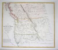
Washington, U.S.A., 1838. Excellent. Notes: Map of Oregon Territory before being officially incorporated as a US Territory on August 14, 1848.Washington Hood (February 2, 1808 – July 17, 1840) was an American (born in Philadelphia) army officer in the Corps of Topographical Engineers. He drafted maps of the American West while exploring the areas (the Ohio Michigan border; northeastern Oklahoma, Indian tribes west of Arkansas and Missouri...etc.)., Size : 443x525 (mm), 17.375x20.625 (Inches), Coloring: Hand Colored in Outline, Reference: Wheat: 433 and 434., Category: Maps Canada West British Columbia;
Map of the United States Territory of Oregon West of the Rocky Mountains. by HOOD, Washington - 1838
by HOOD, Washington
Similar copies are shown below.
Similar copies are shown to the right.

Map of the United States Territory of Oregon West of the Rocky Mountains.
by HOOD, Washington
- Used
- first
Washington: Bureau of Topographic Engineers, 1838. First edition. 17 x 21 inches. Drawn by Hood and engraved by M. H. Stansbury. Lithographed by W.J. Stone. Based on Arrowsmith's 1834 map of British North America. Some toning. Nicely framed.
"Renewed congressional activity on the desirability of occupying the Oregon Territory began to include maps. In 1838, Senator Lewis Linn presented a bill to authorize the president to occupy the area. The bill was accompanied by a ÒMap of the United States Territory of Oregon West of the Rocky Mountains,Ó drawn by Washington Hood of the Corps of Topographical Engineers. The map included text relating to ongoing British and American negotiations on the 49th parallel boundary" (Oregon Encyclopedia)
-
Bookseller
Nat DesMarais Rare Books, ABAA
 (US)
(US)
- Book Condition Used
- Quantity Available 1
- Publisher Bureau of Topographic Engineers
- Place of Publication Washington
- Date Published 1838
We have 1 copies available starting at $975.00.
Map of the United States Territory of Oregon West of the Rocky Mountains...
by Washington Hood (1808-1840); M.H. Stansbury
- Used
- Condition
- Used - Excellent
- Quantity Available
- 1
- Seller
-
Toronto, Ontario, Canada
- Item Price
-
$975.00
Show Details
Item Price
$975.00