Description:
Augsburg: Seutter, 1740. VG+, copperplate engraving with original hand coloring (color similar to Homann, with whom Seutter apprenticed before going out on his own in about 1707). There is minimal right marginal soling, but the image and color are exceptionally bright. Decorative cartouche, as usual, probably an allegorical representation of imperial Russia. The map measures 19.25x22.5 inches. .
A New British Atlas; Comprising a Series of 54 Maps, Constructed from the Most Recent Surveys and Engraved By Sidney Hall by HALL, Sidney - 1834
by HALL, Sidney

A New British Atlas; Comprising a Series of 54 Maps, Constructed from the Most Recent Surveys and Engraved By Sidney Hall
by HALL, Sidney
- Used
- very good
- Hardcover
- first
(London): Chapman & Hall, 1834. First Edit. Half-Leather. Very Good. 4to. Title (neatly repaired), list of maps, 46 hand coloured maps inc. 4 double-page, all with accompanied letterpress. Morocco backed cloth covers with the title in gilt on the upper board. Beautiful original full wash hand colouring, light stain to the Bedfordshire map, otherwise all maps in fine fresh condition. Maps dated 1833. Four pages at the end of the book relate to Inland Navigation (not plates). Chubb calls for a double-page map of the Inland Waterways, there is no sign of this map ever having been bound in this copy.
-
Bookseller
Independent bookstores
 (GB)
(GB)
- Format/Binding Half-Leather
- Book Condition Used - Very Good
- Quantity Available 1
- Edition First Edit
- Binding Hardcover
- Publisher Chapman & Hall
- Place of Publication (London)
- Date Published 1834
- Keywords Maps. Atlases. County Maps. Cartography. British Topography catx97
- Size 4to

(Map of Caspian Sea & Environs): Nova et Accuratissima Maris Caspii...petri Alexii Filii. Magni Russorum Emper
by Seutter, GM
- Used
- Condition
- Used
- Binding
- Unknown
- Quantity Available
- 1
- Seller
-
Crozet, Virginia, United States
- Item Price
-
$550.00
Show Details
Item Price
$550.00

(Map of Eastern America and Atlantic Ocean): Carte De L'Ocean Occidental et Partie De L'Amerique Septentrionale..Charlevoix..fait En 1720
by Bellin, Jacques Nicolas
- Used
- Condition
- Used
- Binding
- Unknown
- Quantity Available
- 1
- Seller
-
Crozet, Virginia, United States
- Item Price
-
$485.00
Show Details
Description:
Paris: Ganeau, 1744. Excellent condition, strong impression, b&w engraved copperplate from Tome III of the 4to, 1744 edition of Charlevoix's "Histoire de la Nouvelle France" (Journal D'un Voyage...). The image is 9.5 x 14.5 inches, with folds as issued. This image has the full eastern USA, including Louisiane, north to Newfoundland, most of the Great Lakes, teh Atlantic Ocean, Acores, and east to the western coasts of Africa, Spain, France and British Isles. It is quite attractive, and not often seen for sale in this early state..
Item Price
$485.00
A List of Geographical Atlases in the Library of Congress with Bibliographical Notes : 9 volumes, complete [new, in publisher's shrinkwrap]
by Phillips, Philip Lee [Vols 1-4]; & Clara Egli LeGear Le Gear [vols 5-9]
- New
- Hardcover
- first
- Condition
- New
- Jacket Condition
- in publisher's shrinkwrap
- Edition
- First Martino printing
- Binding
- Hardcover
- Quantity Available
- 1
- Seller
-
Henderson, Nevada, United States
- Item Price
-
$474.50
Show Details
Description:
Staten Island, New York: Maurizio Martino Publisher, 1995. SEE PHOTO. 9 volumes, complete. BRAND NEW HARDCOVERS in perfect condition. STILL SEALED in the publisher's clear plastic SHRINKWRAP. NO rubbing. NO fading. Bright, clean, square and tight. Sharp corners. NO owner's name or bookplate. NOT a remainder. Fresh and crisp -- obviously never read. The standard reference, complete in 9 volumes. Vols. 1-4 by Philip Lee Phillips. No date (but 1995, First Martino printing "strictly limited to 100"). Reprint of the 1909-1920 Library of Congress originals. Vols 5-9 by Clara Egli Le Gear. No date (but 1996, First Martino printing "strictly limited to 150"). Reprint of the 1958-1992 Library of Congress originals, in continuation of volumes 1-4 by Philip Lee Phillips. These 9 volumes fully describe thousands of atlases, including imprint, collation, details of publication, measurements, content, typographical and numbering errors, comparisons with foreign and…
Read More Item Price
$474.50
More Photos
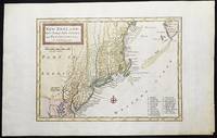
New England, New York, New Jersey, and Pensilvania &c. by H. Moll Geographer
by Moll, Herman
- Used
- near fine
- Condition
- Used - Near Fine
- Binding
- Unknown
- Quantity Available
- 1
- Seller
-
Lansdowne, Pennsylvania, United States
- Item Price
-
$464.00
Show Details
Description:
London: H. Moll, 1708. Near Fine. 1 sheet 232 x 267 mm. (image is 180 x 254 mm.) Hand-colored copper engraved map. This is Herman Moll's earliest map of New England, published in the first edition of John Oldmixon's The British Empire in North America in 1708. List of 19 towns in lower right-hand corner. New Jersey is shown as East New Jersey and West New Jersey. Pennsylvania still contains the Lower Counties, which separated and became Delaware in 1704. On the west side of the Susquehanna River is shown "The Present Sasquahana Indian Fort." In Near Fine Condition: light creasing; clean and bright.
Item Price
$464.00

More Photos
Viaggio a Pompei a Pesto e di ritorno ad Ercolano en a Pozzuoli
by ROMANELLI, Domenico
- Used
- very good
- Paperback
- Condition
- Used - Very Good
- Binding
- Paperback
- Quantity Available
- 1
- Seller
-
Cuernavaca, Mexico
- Item Price
-
$440.00
Show Details
Description:
Napoli, Angelo Trani, 1817En 8vo. 2 Vol. V.I: 288pp, 2 folding fmaps of Pompei and Fondona Pianta.; V. II: 276pp + engraving and one folding map. Original publishers paperback in an elegant full calf box. Hand made paper, uncut. Vol I with old worm marks in several pages (minor text damage).The edition was updated with all of the new disvoveries, a very precise map of Pompey and of the voyage to Pozzuol.Romanelli, Domenico (1756-1819) Abbé. – was an Italian historian and archaeologist. Curator of the Public Library in Napoli.Nice set.
Item Price
$440.00
More Photos
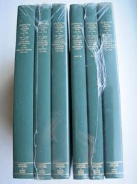
Mapping the Transmississippi West [1995, 6 separate vols, complete; with large FOLD-OUT maps; new, in publisher's shrinkwrap & PUBLISHER'S CARDBOARD SHIPPING BOX
by Wheat, Carl I.
- New
- Hardcover
- first
- Condition
- New
- Jacket Condition
- in publisher's shrinkwrap
- Edition
- First Martino/About Books printing
- Binding
- Hardcover
- Quantity Available
- 1
- Seller
-
Henderson, Nevada, United States
- Item Price
-
$647.50
Show Details
Description:
Storrs-Mansfield, CT / Parsippany, New Jersey: Martino Fine Books / About Books, 1995. 6 separate volumes, complete [5 volumes bound in 6 books WITH LARGE FOLD-OUT MAPS -- just like the first edition]. SEE PHOTOS. Each of the 6 books in this 1995 large format edition measures 9.25" wide by 12.25" tall. [This is NOT the later, smaller format 3-volume reprint in which the maps are reduced in size]. Unlike later reduced-size editions, the maps in this 1995 six-volume edition measure as large as 21" by 33" when unfolded. SEE PHOTOS. As original co-publisher, we are pleased to offer the few remaining sets of the 1995 large-format 6-volume edition (recently rediscovered in our warehouse). They are BRAND NEW in perfect condition. STILL SEALED in the publisher's clear plastic SHRINKWRAP and the PUBLISHER'S CARDBOARD SHIPPING BOX. NO rubbing. NO fading. Bright, clean, square and tight. NO owner's name or bookplate. NOT a remainder. Fresh and crisp -- obviously…
Read More Item Price
$647.50

More Photos
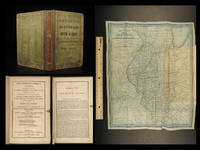
Méthode simple et facile pour lever les plans, suivie d'un traité du nivellement, d'un abrégé des règles du lavis et des élémens de trigonométrie rectiligne
by LECOY, François
- Used
- near fine
- Hardcover
- Condition
- Used - Near Fine
- Edition
- First
- Binding
- Hardcover
- Quantity Available
- 1
- Seller
-
COLUMBIA, Missouri, United States
- Item Price
-
$599.00
Show Details
Description:
1805 Surveying Method Topography COLOR Map Making Landscaping Construction LecoyFrancois Lecoy's 'Simple and Easy Methods for Surveying' is a fine, early 19th-century treatise on the systems used in construction and map preparation. Lecoy discusses the means by which French surveyors level land through the means of linear trigonometry. This 1805 first edition is an exception example of early 19th-century landscaping and topography. Note that this book includes impressive, folding color engravings of topographical examples and surveying tools.
Item number: #11652
Price: $599
LECOY, François
Méthode simple et facile pour lever les plans, suivie d'un traité du nivellement, d'un abrégé des règles du lavis et des élémens de trigonométrie rectiligne
A Paris : Chez Duponcet ..., an XIII=1805. First edition.
Details:
·
Collation: Complete with all pages
o xxxii, 119, [1], 12
o 12 folding plates
·
Provenance: Handwritten – Duponcet
o Signed by the publisher
·… Read More
Item Price
$599.00

More Photos
Atlas to Accompany Monograph XXXII on the Geology of the Yellowstone National Park
by Hague, Arnold
- Used
- good
- Hardcover
- Condition
- Used - Good
- Binding
- Hardcover
- Quantity Available
- 1
- Seller
-
Lansdowne, Pennsylvania, United States
- Item Price
-
$438.00
Show Details
Description:
Washington, D.C.: United States Geological Survey, 1904. Hardcover. Good. 34 leaves: 24 color maps (7 double-leaf); 56 cm. Dark brown cloth with gilt-stamped cover title. Monographs of the United States Geological Survey, v. 32. In Good Condition: cloth is soiled and rubbed; corners are frayed; minor loss at ends of spine; blank leaf preceding title page is torn from fore-edge to gutter; faint dampstain along fore-edges and lower corners throughout, not impacting maps; closed 2-cm. tear from fore-edge of 2 maps; otherwise, clean and tight.
Item Price
$438.00

More Photos
A star atlas for the library, the school, and the observatory showing 6,000 stars and 1,500 objects of interest
by PROCTOR, Richard A
- Used
- near fine
- Hardcover
- Condition
- Used - Near Fine
- Binding
- Hardcover
- Quantity Available
- 1
- Seller
-
COLUMBIA, Missouri, United States
- Item Price
-
$599.00
Show Details
Description:
1874 Astronomy Star ATLAS Zodiac Constellation MAPS Richard Proctor AstrologyRichard Proctor was a 19th-century English astronomer known for his studies on the planets in the solar system as well as the moon and the sun. In his many astronomical books, Proctor discusses his research on the planets, stars and constellations, and the sun, as well as his observations on meteors and comets. His most fascinating work was 'A Star Atlas' – an impressive collection of star and constellation charts and night sky maps.
Item number: #19450
Price: $599
PROCTOR, Richard A
A star atlas for the library, the school, and the observatory showing 6,000 stars and 1,500 objects of interest
London : Longmans, Green, 1874.
Details:
· Collation: Complete with all pages
o
14, [2]
o
14 double-page charts
· Language: English
· Binding: Hardcover; tight and secure
o
Cloth
· Size: ~14.75in X 9.75in (37.5cm x 25cm)
· Quite scarce
Our Guarantee:
Very Fast. Very Safe. Free Shipping… Read More
Item Price
$599.00
More Photos
Illinois in 1837 & 8; a sketch descriptive of the situation, boundaries, face of the country
by MITCHELL, S. Augustus
- Used
- near fine
- Hardcover
- first
- Condition
- Used - Near Fine
- Edition
- First
- Binding
- Hardcover
- Quantity Available
- 1
- Seller
-
COLUMBIA, Missouri, United States
- Item Price
-
$499.00
Show Details
Description:
1838 ILLINOIS Mitchell Geography & Atlas HUGE MAP Chicago Emigrant Western RAREThe name Mitchell has long been synonymous with 19th-century maps; in fact, Mitchell maps are often considered the best of atlas maps from the 1800s. Early in his career S Augustus Mitchell Sr published what became an important geographical history of Illinois, titled "Illinois in 1837". It, as expected, described the physical landscape of Illinois offering notes on prominent cities, rivers, animals, landmarks, public places, and even practical suggestions for emigrants to Illinois. The book saw such success that Mitchell published it again the following year, changing the title slightly to "Illinois in 1837 & 8".
This 1838 edition
features the highly desired folding map
Item number: #21181
Price: $499
MITCHELL, S. Augustus
Illinois in 1837 & 8; a sketch descriptive of the situation, boundaries, face of the country…
Philadelphia: S. Augustus Mitchell, 1838. 1st edition
Details:
·
Collation:
o viii, 9-143,… Read More
Item Price
$499.00

Stock Photo: Cover May Be Different
Christian Anti-Semitism and Paul's Theology
by Sidney G. Hall III
- Used
- Acceptable
- Paperback
- Condition
- Used - Acceptable
- Binding
- Paperback
- ISBN 10 / ISBN 13
- 9780800626549 / 0800626540
- Quantity Available
- 1
- Seller
-
Houston, Texas, United States
- Item Price
-
$6.00
Show Details
Description:
Fortress Press, 1993-01-01. paperback. Acceptable. 5x0x8.
Item Price
$6.00

Christian Anti Sem Pauls Theol
by Hall, Sidney G., III
- Used
- very good
- Paperback
- Condition
- Used - Very Good
- Binding
- Paperback
- ISBN 10 / ISBN 13
- 9780800626549 / 0800626540
- Quantity Available
- 1
- Seller
-
Seattle, Washington, United States
- Item Price
-
$6.39
Show Details
Description:
Augsburg Fortress Publishing, 1993. Paperback. Very Good. May have limited writing in cover pages. Pages are unmarked. ~ ThriftBooks: Read More, Spend Less.Dust jacket quality is not guaranteed.
Item Price
$6.39

Christian Anti Sem Pauls Theol
by Hall, Sidney G., III
- Used
- Acceptable
- Paperback
- Condition
- Used - Acceptable
- Binding
- Paperback
- ISBN 10 / ISBN 13
- 9780800626549 / 0800626540
- Quantity Available
- 1
- Seller
-
Seattle, Washington, United States
- Item Price
-
$6.39
Show Details
Description:
Augsburg Fortress Publishing, 1993. Paperback. Acceptable. Readable copy. Pages may have considerable notes/highlighting. ~ ThriftBooks: Read More, Spend Less.Dust jacket quality is not guaranteed.
Item Price
$6.39

Stock Photo: Cover May Be Different
What We Will Give Each Other
by Hall, Sidney, Jr
- Used
- Condition
- Used - Very Good
- ISBN 10 / ISBN 13
- 9780963641304 / 0963641301
- Quantity Available
- 1
- Seller
-
Waltham, Massachusetts, United States
- Item Price
-
$3.57
Show Details
Description:
Oyster River Pr. Used - Very Good. . . All orders guaranteed and ship within 24 hours. Your purchase supports More Than Words, a nonprofit job training program for youth, empowering youth to take charge of their lives by taking charge of a business.
Item Price
$3.57

Small Town Tales : A Brookline Boyhood
by Hall, Sidney, Jr
- Used
- good
- Paperback
- Condition
- Used - Good
- Binding
- Paperback
- ISBN 10 / ISBN 13
- 9780963641335 / 0963641336
- Quantity Available
- 1
- Seller
-
Seattle, Washington, United States
- Item Price
-
$6.97
Show Details
Description:
Hobblebush Books, 1998. Paperback. Good. Pages can have notes/highlighting. Spine may show signs of wear. ~ ThriftBooks: Read More, Spend Less.Dust jacket quality is not guaranteed.
Item Price
$6.97

Stock Photo: Cover May Be Different
Small Town Tales
by Hall, Sidney Jr
- Used
- good
- Paperback
- Condition
- Used - Good
- Binding
- Paperback
- ISBN 10 / ISBN 13
- 9780963641335 / 0963641336
- Quantity Available
- 1
- Seller
-
Simi Valley, California, United States
- Item Price
-
$2.99
Show Details
Description:
Hobblebush Books, 1998-03-01. Paperback. Good. 0.5000 8.2000 5.4000.
Item Price
$2.99
Stock Photo: Cover May Be Different
Christian Anti-Semitism and Paul's Theology
by Hall, Sidney G., III
- Used
- Condition
- Used - Very Good
- ISBN 10 / ISBN 13
- 9780800626549 / 0800626540
- Quantity Available
- 1
- Seller
-
Mishawaka, Indiana, United States
- Item Price
-
$8.17
Show Details
Description:
1517 Media. Used - Very Good. Former library book; may include library markings. Used book that is in excellent condition. May show signs of wear or have minor defects.
Item Price
$8.17
Stock Photo: Cover May Be Different
Christian Anti-Semitism and Paul's Theology
by Hall, Sidney G., III
- Used
- Condition
- Used - Very Good
- ISBN 10 / ISBN 13
- 9780800626549 / 0800626540
- Quantity Available
- 1
- Seller
-
Mishawaka, Indiana, United States
- Item Price
-
$8.42
Show Details
Description:
1517 Media. Used - Very Good. Used book that is in excellent condition. May show signs of wear or have minor defects.
Item Price
$8.42
Stock Photo: Cover May Be Different
Christian Anti-Semitism and Paul's Theology
by Sidney G. Hall
- Used
- good
- Paperback
- Condition
- Used - Good
- Binding
- Paperback
- ISBN 10 / ISBN 13
- 9780800626549 / 0800626540
- Quantity Available
- 1
- Seller
-
HOUSTON, Texas, United States
- Item Price
-
$8.66
Show Details
Description:
Augsburg Fortress Pub, 1993-05. Paperback. Good.
Item Price
$8.66
Stock Photo: Cover May Be Different
Small Town Tales: A Brookline Boyhood
by Sidney, Jr. Hall
- Used
- good
- Paperback
- Condition
- Used - Good
- Binding
- Paperback
- ISBN 10 / ISBN 13
- 9780963641335 / 0963641336
- Quantity Available
- 1
- Seller
-
HOUSTON, Texas, United States
- Item Price
-
$9.06
Show Details
Description:
Hobblebush Books, 1998-03. Paperback. Good.
Item Price
$9.06

More Photos
The Sky and the Forest
by Forester, C.S
- Used
- very good
- Hardcover
- first
- Condition
- Used - Very Good
- Jacket Condition
- Very Good
- Edition
- First Edition
- Binding
- Hardcover
- Quantity Available
- 1
- Seller
-
Salem, Oregon, United States
- Item Price
-
$34.89$20.93Save $13.96!
Show Details
Description:
C.S. Forester: The Sky and the Forest. Little, Brown and Company, Boston. Stated First Edition First Printing Thus August, 1948. Cover price $2.75. Used. VG BOOK/VG UNCLIPPED DUST JACKET. A story of a central Africa. By C.S. Forester, author of the Admiral Hornblower series.
Item Price
$34.89$20.93
Save $13.96
!
![Alaska and Klondike Region; [With inset of Klondike Region on the Upper Yukon detail] [From an...](https://d3525k1ryd2155.cloudfront.net/h/062/537/1339537062.0.m.jpg)
Alaska and Klondike Region; [With inset of Klondike Region on the Upper Yukon detail] [From an atlas, "Gazetteer of Alaska and Yukon Region " pp. 105 and 106]
by Miller, J. Martin
- Used
- very good
- Condition
- Used - Very Good
- Edition
- Unknown
- Quantity Available
- 1
- Seller
-
Sebastopol, California, United States
- Item Price
-
$39.00
Show Details
Description:
Chicago: J. Martin Miller, 1899. Unknown. Map. Very Good. [Map copyright 1899, printing date of Atlas later] [19.875x15.125in]; Colored map of Alaska with steamer routes from Portland and Seattle, insets of the Klondike Region on the Upper Yukon and Western portion of Aleutian Islands; On verso index of places and names with two large black and white images; Age toning to all edges, water stain marks on bottom, slight printing offset of colors, small chips and closed tears to lower edge;.
Item Price
$39.00

Zemepis Sveta - Monsunova Asie
by De La Blache, P. Vidal; Gallois, L
- Used
- Hardcover
- Condition
- Used - Very Good Condition
- Jacket Condition
- No Dust Jacket
- Binding
- Hardcover
- Quantity Available
- 1
- Seller
-
Oak Point, Texas, United States
- Item Price
-
$60.00
Show Details
Description:
Aventinum, Prague, Czechoslovakia, 1931. Hardcover. Very Good Condition/No Dust Jacket. Text entirely in Czech. Geography book on Asia with numerous photographs and maps. 1930 edition also available. Size: 4mo - over 9 3/4" - 12" tall. 400 pp. Pages are yellowed, but are tight and clean. Moderate shelfwear along the spine. Corners are lightly bumped. Quantity Available: 1. Shipped Weight: 3-5 pounds. Category: Travel & Places; Non-English Language::Czech; Pictures of this item not already displayed here available upon request. Inventory No: 001228. . Additional shipping charges may apply.
Item Price
$60.00

Zemepis Sveta - Monsunova Asie
by De La Blache, P. Vidal; Gallois, L
- Used
- Hardcover
- Condition
- Used - Very Good Condition
- Jacket Condition
- No Dust Jacket
- Binding
- Hardcover
- Quantity Available
- 1
- Seller
-
Oak Point, Texas, United States
- Item Price
-
$60.00
Show Details
Description:
Aventinum, Prague, Czechoslovakia, 1930. Hardcover. Very Good Condition/No Dust Jacket. Text entirely in Czech. Geography book on Asia with numerous photographs and maps. 1931 edition also available. Size: 4mo - over 9 3/4" - 12" tall. 400 pp. Pages are yellowed, but are tight and clean. Moderate shelfwear along the spine. Corners are lightly bumped. Quantity Available: 1. Shipped Weight: 3-5 pounds. Category: Travel & Places; Non-English Language::Czech; Pictures of this item not already displayed here available upon request. Inventory No: 001227. . Additional shipping charges may apply.
Item Price
$60.00

North America from the Best Authorities, Russell, ca.1800
by Russell
- Used
- Condition
- Used
- Quantity Available
- 1
- Seller
-
Plymouth, Devon, United Kingdom
- Item Price
-
$25.12
Show Details
Description:
Russell, J. : A General Map of North America from the Best Authorities. Nd but ca.1800. From "A New Geographical, Historical and Commercial Grammar and Present State of Several Kingdoms of the World." Copper engraving. Size approx 200 x 230mm. Two neat folds. Some age colouring to edges, otherwise very clean and bright.
Item Price
$25.12

Asia from the Best Authorities, Russell, ca.1800
by Russell
- Used
- Condition
- Used
- Quantity Available
- 1
- Seller
-
Plymouth, Devon, United Kingdom
- Item Price
-
$25.12
Show Details
Description:
Russell, J. : Asia from the Best Authorities. Nd but ca.1800. From "A New Geographical, Historical and Commercial Grammar and Present State of Several Kingdoms of the World". Copper engraving. Size approx 200 x 230mm. Two neat folds. Some age colouring to edges, otherwise clean and bright. Includes Arabia, India, Borneo, Japan, China and eastern Russia.
Item Price
$25.12
![MAP OF UTAH [Territory]](https://d3525k1ryd2155.cloudfront.net/h/836/461/1485461836.0.m.jpg)
More Photos
MAP OF UTAH [Territory]
- Used
- Condition
- Used - Very Good-
- Edition
- Original
- Quantity Available
- 1
- Seller
-
Williamsburg, Virginia, United States
- Item Price
-
$65.00
Show Details
Description:
New York, Richmond, Chicago, & Toledo: H. H. Hardesty, 1885. Original color lithographed map printed by Rand, McNally & Company, Engravers and published in HARDESTY'S HISTORICAL AND GEOGRAPHICAL ENCYCLOPEDIA: SPECIAL VIRGINIA EDITION. 19 3/8 inches by 13 1/4 inches on a 21" X 14 1/2" sheet. The map depicts the Territory of Utah in its final form--large areas had been removed and ceded to Nevada, Colorado, Wyoming, and Nebraska since Utah became a U. S. Territory in 1850. The issue of polygamy prevented statehood until it was finally granted in 1896. This map features railroads and topography and uses color to set off counties from each other. Unlike most atlas maps of the period, this map identifies most small towns. The map is guaranteed to be moe than 135 years old. The map is in about very good condition: generally clean and bright, with slight toning of paper and one faint water stain near the center-left edge of the map.. Original. Single Sheet. Very Good-. Elephant…
Read More Item Price
$65.00

Philips Special Map of the Nile, The Advance on Khartum and the Environs of Omdurman. Cc1900
by George Philips and Son,
- Used
- Condition
- Used
- Quantity Available
- 1
- Seller
-
Plymouth, Devon, United Kingdom
- Item Price
-
$32.66
Show Details
Description:
Philips Special map of the Nile illustrating the Advance on Khartum [Khartoum] with an enlargement of the environs of Omdurman [Omdur]. George Philips and Son, London and Liverpool Ca 1900. 580mm x 900mm folded map. Front title wrapper has come loose, not affecting map area. Three maps are displayed within the sheet. Map1. Map of the Nile Valley 520mm x 300mm showing the approaches of Khartum. Scale 1inch to 100 Geographical miles. Coloured indicating Possessions and Protectorates of European Powers. Map 2. Special map of the Nile from Dongola to Khartum. Scale 16 miles to the inch. Coloured. In set in this map is Map3. Environs of Omdurman, Scale 5 statute miles to the inch. Some small breaks at some folds, not affecting imagery or use of map. Title label is damaged, the map is clean and bright, probably unused. A very interesting record.
Item Price
$32.66

Last Tales
by Dinesen, Isak
- Used
- very good
- Hardcover
- first
- Condition
- Used - Very Good
- Jacket Condition
- Good+
- Edition
- First Edition
- Binding
- Hardcover
- Quantity Available
- 1
- Seller
-
Salem, Oregon, United States
- Item Price
-
$120.00$72.00Save $48.00!
Show Details
Description:
Dinesen, Isak: Last Tales, A Collection of Twelve New Tales of Compelling Beauty 1957, Random House. First Edition. Stated First Printing Thus. Used. Very Good/Good+ original red dust jacket, price-clipped. Jacket states 11/57 on front flap. 5 3/4 X
Item Price
$120.00$72.00
Save $48.00
!

The Adventure of Wrangel Island
by Vilhjalmur Stefansson
- Used
- good
- Hardcover
- first
- Condition
- Used - Good
- Jacket Condition
- No DJ Included
- Edition
- First Edition
- Binding
- Hardcover
- Quantity Available
- 1
- Seller
-
Salem, Oregon, United States
- Item Price
-
$124.89$74.93Save $49.96!
Show Details
Description:
The Adventure of Wrangel Island, Alaska (1925 Macmillan 1st Edition) HISTORY OF ALASKA. EXLIB. Good Condition/ No DJ included. Fold-out map affixed to binding at the back of the book has never been opened. The story of the (unsuccessful) attempted colonization of Wrangel Island Alaska. 413 pages plus appendix, Index. Titling is still bright. A clean, solid copy. Scarce.
Item Price
$124.89$74.93
Save $49.96
!