Description:
|Hand-coloured engraved County Map, compass rose, from Smith's New English Atlas, horizontal crease, small tear in left margin, small split in edge of central fold, Attractive finely coloured map.
A New Map of the County of Devon Divided into Hundreds by SMITH, Charles - 0
by SMITH, Charles
Similar copies are shown below.
Similar copies are shown to the right.
A New Map of the County of Devon Divided into Hundreds
by SMITH, Charles
- Used
- near fine
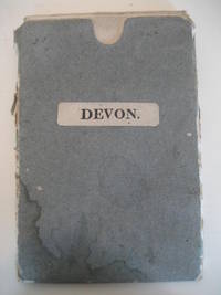
3rd edition. Corrected to 1818. Map. Near Fine. 485 x 445 mm. Folding map mounted on linen, dissecting into 12 sections, with original full wash hand colouring. In original grey paper covered slipcase with printed title label (no publisher). Batten & Bennett, 63.5, " Dissecting maps in slip cases are known for some counties . G W Canal branch shown to Tiverton. Key for Turnpike Roads changed to Great Roads. Many other changes "
-
Seller
Independent bookstores
 (GB)
(GB)
- Format/Binding Map
- Book Condition Used - Near Fine
- Quantity Available 1
- Edition 3rd edition. Corrected to 1818
- Keywords DEVON. DEVON MAPS. FOLDING
- Size 485 x 445 mm
We have 8 copies available starting at $44.34.

A New Map of the County of Buckinghamshire Divided into Hundreds.
by BUCKINGHAMSHIRE. CHARLES SMITH
- Used
- Condition
- Used
- Quantity Available
- 1
- Seller
-
Ilminster, Somerset, United Kingdom
- Item Price
-
$44.34
Show Details
Item Price
$44.34
A New Map of the County of Suffolk. Divided into Hundreds.
by Charles Smith
- Used
- very good
- Paperback
- Condition
- Used - Very Good
- Binding
- Paperback
- Quantity Available
- 1
- Seller
-
Aldeburgh, Suffolk, United Kingdom
- Item Price
-
$76.02
Show Details
Description:
London: C. Smith,, 1818. Paperback . Very Good. Linen backed, hand coloured, folding map. 20 x 18 inches, 15 panels folding down to twelvemo in original slipcase. Some marking and fading, some rubbing to edges (slightly rubbed through at some corners) otherwise a good-plus copy in worn but usable slipcase.
Item Price
$76.02

Huntingdonshire. A New Map of the County of Huntingdon. divided into Hundreds. London. Printed for C. Smith No. 172 Strand. January 6th 1804.
by SMITH, Charles
- Used
- Condition
- Used
- Quantity Available
- 1
- Seller
-
London, London, United Kingdom
- Item Price
-
$95.02
Show Details
Description:
London: Charles Smith & Co. 1804. Sheet size: 68 x 53 cm. Map size: 50 x 44 cm. Original hand colour. Copper engraved map of the county of Huntingdon from Charles Smith's 'New English Atlas' of 1804. With details of distances from London and certain landmarks such as churches and chapels marked. With a key and an explanatory reference to the 'hundreds'. Good condition.
Item Price
$95.02

Lincolnshire. A New Map of the County of Lincoln. Divided into Wapontakes &c. London. Printed for C. Smith No. 172 Strand. January 6th 1804.
by SMITH, Charles
- Used
- Condition
- Used
- Quantity Available
- 1
- Seller
-
London, London, United Kingdom
- Item Price
-
$126.70
Show Details
Description:
London: Charles Smith & Co. 1804. Sheet size: 68 x 53 cm. Map size: 49 x 44 cm. Original hand colour. Copper engraved map of the county of Lincoln from Charles Smith's 'New English Atlas' of 1804. With details of distances from London and certain landmarks such as churches and chapels marked. With a key and an explanatory reference to the wapontakes ('hundreds'). Tear at join, otherwise good condition.
Item Price
$126.70

Cambridgeshire. A New Map of the County of Cambridge. divided into Hundreds. London. Printed for C. Smith No. 172 Strand. January 6th 1804.
by SMITH, Charles
- Used
- Condition
- Used
- Quantity Available
- 1
- Seller
-
London, London, United Kingdom
- Item Price
-
$158.38
Show Details
Description:
London: Charles Smith & Co. 1804. Sheet size: 68 x 53 cm. Map size: 49 x 45 cm. Original hand colour. Copper engraved map of the county of Cambridge from Charles Smith's 'New English Atlas' of 1804. With details of distances from London and certain landmarks such as churches and chapels marked. With a key and an explanatory reference to the 'hundreds'. Slight tear at join, some light spots to margins. Generally in good condition.
Item Price
$158.38

Large Map of County Waterford in the 18th century: "A New and Correct Map of the County of Waterford by Charles Smith".
by [Luckombe, Philip] Smith, Charles
- Used
- Condition
- Used
- Quantity Available
- 1
- Seller
-
Skibbereen, Ireland
- Item Price
-
$407.10
Show Details
Description:
2023. Skibbereen, Inanna Rare Books & Art Publishing House, 2023. Luxury Fine Art Giclée Reprint of the Engraving which was originally created by Charles Smith but later pirated/printed without permission in London by publisher Philip Luckombe in the year 1788. Image Size: 53 cm wide x 40 cm high. Sheet Size: 59 cm wide x 46 cm high. Excellent condition. © Copyright by Inanna Rare Books Ltd. [Price includes 23% VAT (70,12 ) / Net: (304,88 )] The early Map of County Waterford. Philip Luckombe included this map / illustration in "The Compleat Irish Traveller" in the year 1788. It was originally published by Charles Smith in his publication "The Antient And Present State of The County And City Of Waterford" (1746).
Item Price
$407.10

Large Map of County Cork in the 18th century: "A New and Correct Map of the County of Cork - To the Nobility and Gentlemen of this County, this Map drawn from an actual Survey is inscribed by their Most obedient humble Servant - Charles Smith".
by [Luckombe, Philip] Smith, Charles
- Used
- Condition
- Used
- Quantity Available
- 1
- Seller
-
Skibbereen, Ireland
- Item Price
-
$407.10
Show Details
Description:
2023. Skibbereen, Inanna Rare Books & Art Publishing House, 2023. Luxury Fine Art Giclée Reprint of the Engraving which was originally created by Charles Smith but later pirated/printed without permission in London by publisher Philip Luckombe in the year 1788. Image Size: 75,3 cm wide x 53 cm high. Sheet Size: 81 cm wide x 59 cm high. Excellent condition. © Copyright by Inanna Rare Books Ltd. [Price includes 23% VAT (70,12 ) / Net: (304,88 )] The early Map of County Cork with Coat of Arms of County Cork Families of the 18th century and wonderful detail of West Cork and the Coast from Cork Harbour all the Way to Cape Clear. Philip Luckombe included this map in his publication "The Compleat Irish Traveller" in the year 1788. It was originally published by Charles Smith in his publication "The Antient And Present State of The County And City Of Cork" (1750). The Map of County Cork is not only showing in fine detail the Towns and Villages of 18th century County Cork and especially West Cork but…
Read More Item Price
$407.10

More Photos
THE ANTIENT AND PRESENT STATE OF THE COUNTY OF DOWN. CONTAINING A CHOROGRAPHICAL DESCRIPTION, WITH THE NATURAL AND CIVIL HISTORY OF THE SAME. ILLUSTRATED BY OBSERVATIONS MADE ON THE BARONIES, PARISHES, TOWNS, VILLAGES, CHURCHES, ABBEYS, CHARTER SCHOOLS, MOUNTAINS, RIVERS, LAKES, MEDICINAL AND OTHER SPRINGS, &c. WITH A SURVEY OF THE NEW CANAL; AS ALSO, A NEW AND CORRECT MAP OF THE COUNTY
by Smith, Charles and Walter Harris
- Used
- very good
- Hardcover
- first
- Condition
- Used - Very Good
- Edition
- First Edition
- Binding
- Hardcover
- Quantity Available
- 1
- Seller
-
Eugene, Oregon, United States
- Item Price
-
$1,650.00
Show Details
Description:
Dublin, Ireland: A. Reilly, 1744. First Edition. Leather-bound. Very Good. Small octavo, 5 x 8 in., pp. xvii + 2 (Contents) + 271 + [1] + 20 (unpaginated Index). Illustrated with fold-out map (16 x 11.5 inches) of the county of Down, Full calf with gilt double frame to front and rear boards, and gilt title on red morocco label to rebacked spine. Five raised bands to spine. Gilt board edges. Publisher's red stain to edges. Light rubbing to extremities. Unmarked bookplate with coat of arms and the motto "Acuspide Corona" ("from the spear, a crown") to front pastedown. Age-toning to pages. Map has light age-toning and small creases and two 1/2 inch closed tears to bottom right. ESTC T144670. Bookplate motto and heraldic coat of arms corresponds to Brodrick, Viscount Midleton. Smith, Charles (1715?-1762), apothecary, topographer, and writer, was born in Co. Waterford. Details of his life remain obscure, but he was educated in medicine and worked as an apothecary in Lismore (1739-44) and Dungarvan, Co.…
Read More Item Price
$1,650.00