Description:
58 Holborn Hill, London: William Darton, 1820. Cloth. Very Good. In embossed cloth, folio 7.5*4 inches, titles and tooling in gilt, corners and edges rubbed. Spine no title, edges bumped. Internally, bookseller label and ink signature to fpd (dated 1836), 24 panels mounted on linen, attractive vignette of Snowdon at L corner, short note, explanation and list of Market Towns and Days. Number 41 of A Complete Atlas of the English Counties which was began by Dix and upon his death, completed by Darton, outlines coloured, 28.5*22.75 inches when full opened. (Chubb 276. Worms 184) William, publisher who like his father specialized in children's books. He also published jigsaw puzzles and table games notable for their decorative detail. Among the firm's authors were the unidentified Arabella Argus, Mary Belson Elliott, and Mary Robson Hughs. He was a skilled engraver, and finished the work on A Complete Atlas of the English Counties, begun by Thomas Dix and published from Holborn Hill under…
Read More A New Map of North Wales divided Into Its Six Counties or Shires. by DIX, Thomas - 1820
by DIX, Thomas
Similar copies are shown below.
Similar copies are shown to the right.
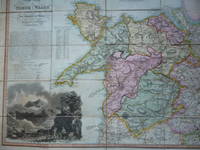
A New Map of North Wales divided Into Its Six Counties or Shires.
by DIX, Thomas
- Used
- first
(London): William Darton, 1820. Folding map with original full wash hand colouring. Dissecting in 20 sections and mounted on linen in original slipcase. Fabulously hand coloured map, with large vignette of Snowdon in one corner, and historical notes in another, and a list of market towns and market days, etc. In 1822 Thomas Dix and William Darton published an atlas titled," Complete Atlas of the Counties of England," The maps were also issued separately as single sheets or cut, mounted and cased [as with the copy we offer here].. First Edit. Map. Very Good.. Book.
-
Bookseller
Independent bookstores
 (GB)
(GB)
- Format/Binding
- Book Condition Used - Very Good.
- Edition First Edit
- Publisher William Darton
- Place of Publication (London)
- Date Published 1820
- Keywords Wales. North Wales. Welsh Maps. Maps. Folding Maps. Cartography. Dix. Snowdon. CATX100
We have 1 copies available starting at $232.38.

More Photos
A new Map of North Wales divided into its Six Counties or Shires.
by DIX Thomas 1769-1813. DARTON William 1781-1854
- Used
- very good
- Hardcover
- Condition
- Used - Very Good
- Binding
- Hardcover
- Quantity Available
- 1
- Seller
-
Llandudno, Conwy, United Kingdom
- Item Price
-
$232.38
Show Details
Item Price
$232.38