
Click for full-size.
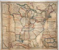
A New Map of the United States upon which are delineated the vast works of International communication, Routes Across the Continent, &c. showing also Canada and the Island of Cuba
by Williams, Wellington
- Used
- first
- Condition
- See description
- Seller
-
Garrison, New York, United States
Payment Methods Accepted
About This Item
Philadelphia: Lippincott, Grambo & Co, 1851. First printing. Original outline color engraved map of the eastern half of the United States and part of Canada. Published during the California gold rush era and prior to the Civil War, the main map extends as far west as Nebraska, "Indian Territory" and Texas; one of the insets shows the far western states divided according to the boundaries of the Compromise of 1850. Also shown are routes to the west, railroads, cities & towns, roads & canals. With four insets, including:
Map of California, Oregon, New Mexico, Utah etc. This insert completes the larger map with Mexico in the south & the British Possessions in the north. The eastern border runs through Minnesota, part of the North West Terretory, Nebraska and Texas; Map of the island of Cuba; and City & Harbor of Havana; and Map of the Niagara River and Falls.
Some light browning along the original folds, and there is some brown markings around the title.
Image size: 29 1/2 x 24 1/4". Paper size: 30 1/4 x 25 1/2". Original hand color map Reference: LC Railroad maps, 21. Wheat, C. I. (TM) 769 & 818.
Reviews
(Log in or Create an Account first!)
Details
- Bookseller
- Antipodean Books, Maps & Prints
 (US)
(US)
- Bookseller's Inventory #
- 15888
- Title
- A New Map of the United States upon which are delineated the vast works of International communication, Routes Across the Continent, &c. showing also Canada and the Island of Cuba
- Author
- Williams, Wellington
- Book Condition
- Used
- Quantity Available
- 1
- Edition
- First printing
- Publisher
- Lippincott, Grambo & Co
- Place of Publication
- Philadelphia
- Date Published
- 1851
- Bookseller catalogs
- MAPS;
Terms of Sale
Antipodean Books, Maps & Prints
30 day return guarantee, with full refund including shipping costs for up to 10 days after delivery if an item arrives mis-described or damaged.
About the Seller
Antipodean Books, Maps & Prints
Biblio member since 2009
Garrison, New York
About Antipodean Books, Maps & Prints
Booksellers for over 40 years, members of prominent trade associations (ABAA, ILAB, ANZAAB, IMCOS, ANZMS, PBFA). We are located at Garrison NY, a stone's throw from the Metro North Hudson line train, just over 1 hr. from NYC on the banks of the Hudson River. Books, maps, prints & ephemera bought & sold.
Glossary
Some terminology that may be used in this description includes:
- New
- A new book is a book previously not circulated to a buyer. Although a new book is typically free of any faults or defects, "new"...
Frequently asked questions
This Book’s Categories

Browse rare books
Interested in rare and collectible books? Booksellers from around the world showcase some of their finest in Biblio’s rare book room.

Collecting Little Golden Books
These iconic childrens board books are collectible if you can find an original in great condition! Learn more about collecting Little Golden Books.