Description:
Lioncrest Publishing, 5/2/2019 12:00:01 AM. paperback. Very Good. 0.5000 in x 8.4000 in x 5.4000 in. Crease on cover and a few pages*
Pays Situe entre Frog's Point et Croton River et Position des Armees Americaine et Brittanique Depuis le 12 Octobre 1776, jusqu'au 28 du meme mois qu'elles engagerent le Combat sur les Plaines Blanches. Revolutionary War map by Marshall, John - 1807
by Marshall, John
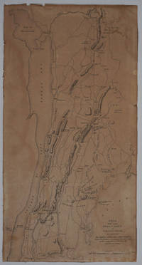
Pays Situe entre Frog's Point et Croton River et Position des Armees Americaine et Brittanique Depuis le 12 Octobre 1776, jusqu'au 28 du meme mois qu'elles engagerent le Combat sur les Plaines Blanches. Revolutionary War map
by Marshall, John
- Used
Paris: Dentu, 1807. Good condition. Copper engraved map from John Marshall's 'Vie de George Washington', a fascinating record of British and American Revolutionary War battles in New York and New Jersey. Showing the battle area in Westchester County (N.Y.) and the Bronx, New York, from Haverstraw in the north down to Fort Washington on the Hudson, and as far east as Rye, NY. Shows position and movement of troops, and the Battle of White Plains. Important historical details indicated on the map include the locations of ships, armies, names of commanders, troop movements and positions, as well as dates, towns, rivers and forts. Trimmed to inside the border, somewhat toned. 8 1/2 x 16 1/4"
-
Bookseller
Antipodean Books, Maps & Prints
 (US)
(US)
- Book Condition Used - Good condition
- Quantity Available 1
- Publisher Dentu
- Place of Publication Paris
- Date Published 1807

Stock Photo: Cover May Be Different
Your Next Adventure: Planning for Life After the Sale of Your Business
by Rowe, Marshall,Fitts, Jim,Weeks, John
- Used
- very good
- Paperback
- Condition
- Used - Very Good
- Binding
- Paperback
- ISBN 10 / ISBN 13
- 9781544502144 / 1544502141
- Quantity Available
- 1
- Seller
-
HILLSIDE, New Jersey, United States
- Item Price
-
$1.50
Show Details
Item Price
$1.50
Stock Photo: Cover May Be Different
Your Next Adventure: Planning for Life After the Sale of Your Business
by Rowe, Marshall,Fitts, Jim,Weeks, John
- Used
- good
- Paperback
- Condition
- Used - Good
- Binding
- Paperback
- ISBN 10 / ISBN 13
- 9781544502144 / 1544502141
- Quantity Available
- 2
- Seller
-
HILLSIDE, New Jersey, United States
- Item Price
-
$1.50
Show Details
Description:
Lioncrest Publishing, 5/2/2019 12:00:01 AM. paperback. Good. 0.5000 in x 8.4000 in x 5.4000 in. Crease on cover and a few pages*
Item Price
$1.50

Stock Photo: Cover May Be Different
Wide-Open World: How Volunteering Around the Globe Changed One Family's Lives Forever
by Marshall, John
- Used
- Condition
- UsedGood
- ISBN 10 / ISBN 13
- 9780345549648 / 0345549643
- Quantity Available
- 1
- Seller
-
Imperial, Missouri, United States
- Item Price
-
$4.52
Show Details
Description:
UsedGood. The item shows wear from consistent use, but it remains in good condition and works perfectly. All pages and cover are intact (including the dust cover, if applicable). Spine may show signs of wear. Pages may include limited notes and highlighting. May NOT include discs, access code or other supplemental materials.
Item Price
$4.52

Have Your Bread and Eat It: The Complete Starch Blocker Weight Control Story
by Marshall, J. John; Lemon, J. Robert
- Used
- Fine
- Paperback
- Condition
- Used - Fine
- Binding
- Paperback
- Quantity Available
- 1
- Seller
-
Oxford, Michigan, United States
- Item Price
-
$1.16
Show Details
Description:
Unknown. PAPERBACK. B000HD9FSS Although the book is actually brand new, some mild accidental wear to the cover, keeps me from listing it as such. Otherwise, the book is still basically brand new. Ships, well packaged and very quickly, from MI. A detailed description is coming soon. The condition selected for the item is accurate and consistent with our other listings of the same general condition. If you have any questions or you would like a detailed description of the item prior to our revision of the listing, please do not hesitate to contact us. We will get back to you as quickly as possible. Please buy with confidence from us, as we have several thousand satisfied customers and your satisfaction is the goal we strive to achieve with every transaction. . Fine.
Item Price
$1.16

Stock Photo: Cover May Be Different
The Doula Book: How a Trained Labor Companion Can Help You Have a Shorter, Easier, and Healthier Birth (A Merloyd Lawrence Book)
by Klaus, Marshall H., Kennell, John H., Klaus, Phyllis H
- Used
- Condition
- Used - Good
- ISBN 10 / ISBN 13
- 9780738215068 / 0738215066
- Quantity Available
- 1
- Seller
-
Waltham, Massachusetts, United States
- Item Price
-
$1.98
Show Details
Description:
Da Capo Lifelong Books. Used - Good. A sound copy with only light wear. Overall a solid copy at a great price!
Item Price
$1.98

Stock Photo: Cover May Be Different
Maternal-Infant Bonding : The Impact of Early Separation or Loss on Family Development
by Kennell, John H., Klaus, Marshall H
- Used
- Condition
- Used - Good
- ISBN 10 / ISBN 13
- 9780801626302 / 0801626307
- Quantity Available
- 1
- Seller
-
Reno, Nevada, United States
- Item Price
-
$5.00
Show Details
Description:
Mosby. Used - Good. Used book that is in clean, average condition without any missing pages.
Item Price
$5.00

Stock Photo: Cover May Be Different
Human Behavior in Global Perspective : An Introduction to Cross-Cultural Psychology
by Poortinga, Ype H., Dasen, Pierre R., Segall, Marshall H., Berry, John W
- Used
- Condition
- Used - Good
- ISBN 10 / ISBN 13
- 9780080368139 / 0080368131
- Quantity Available
- 1
- Seller
-
Reno, Nevada, United States
- Item Price
-
$5.00
Show Details
Description:
PPI-UK. Used - Good. Used book that is in clean, average condition without any missing pages.
Item Price
$5.00

Stock Photo: Cover May Be Different
The Life of George Washington
by MARSHALL, John
- Used
- Condition
- Used - Good
- ISBN 10 / ISBN 13
- 9780865972773 / 086597277x
- Quantity Available
- 1
- Seller
-
Reno, Nevada, United States
- Item Price
-
$5.00
Show Details
Description:
Liberty Fund, Incorporated. Used - Good. Former library book; may include library markings. Used book that is in clean, average condition without any missing pages.
Item Price
$5.00
Stock Photo: Cover May Be Different
Maternal-Infant Bonding : The Impact of Early Separation or Loss on Family Development
by Kennell, John H., Klaus, Marshall H
- Used
- Condition
- Used - Good
- ISBN 10 / ISBN 13
- 9780801626302 / 0801626307
- Quantity Available
- 1
- Seller
-
Mishawaka, Indiana, United States
- Item Price
-
$5.00
Show Details
Description:
Mosby. Used - Good. Used book that is in clean, average condition without any missing pages.
Item Price
$5.00

Stock Photo: Cover May Be Different
Accounting Information Systems
by Romney, Marshall B., Steinbart, Paul John
- Used
- Condition
- Used - Good
- ISBN 10 / ISBN 13
- 9780136015185 / 0136015182
- Quantity Available
- 1
- Seller
-
Mishawaka, Indiana, United States
- Item Price
-
$5.10
Show Details
Description:
Pearson Education, Limited. Used - Good. Former library book; may include library markings. Used book that is in clean, average condition without any missing pages.
Item Price
$5.10