Description:
CLB. Used - Good. Used book that is in clean, average condition without any missing pages.
Philips' Handy Atlas and Gazetteer of the British Isles by George Philip
by George Philip

Philips' Handy Atlas and Gazetteer of the British Isles
by George Philip
- Used
- good
- Hardcover
London: George Philip & Son Ltd. Hardback. Good/No Jacket. 677 8vo. Red embossed cloth-covered boards, gilt titles to spine and front board. Contents of the maps suggest that they date from some time between 1903 and 1908. Includes railway maps. Contents: Part I, The British Isles (plates of flags, general maps of the British isles, maps showing rainfall, crops etc) plates 1-23. Part II England and Wales, text to p 19 (Introduction, then lists of Parliamentary Boroughs etc), then maps plates 1-66. Part III Scotland, text to p 6, maps plates 1-37. Part IV Ireland, text to page 8, maps plates 1-37. Condition notes: Boards rubbed and bumped, cloth worn, spine strip age-darkened and worn, areas of loss to top and bottom, joints very worn. Internally, clean bright maps and other plates, binding pulling here and there.
-
Bookseller
Independent bookstores
 (GB)
(GB)
- Format/Binding Hardback
- Book Condition Used - Good
- Jacket Condition No Jacket
- Binding Hardcover
- Publisher George Philip & Son Ltd
- Place of Publication London
- Keywords Atlas, Great Britain, British Isles
- Size 677 8vo
Rolls-Royce
by Bishop, George, Clucas, Philip
- Used
- Condition
- Used - Good
- ISBN 10 / ISBN 13
- 9780862830298 / 086283029x
- Quantity Available
- 1
- Seller
-
Mishawaka, Indiana, United States
- Item Price
-
$5.00
Show Details
Item Price
$5.00

Stock Photo: Cover May Be Different
Transcultural Leadership
by Simons, George F., Harris, Philip R., Vazquez, Carmen
- Used
- Condition
- Used - Very Good
- ISBN 10 / ISBN 13
- 9780872012998 / 0872012999
- Quantity Available
- 1
- Seller
-
Reno, Nevada, United States
- Item Price
-
$5.00
Show Details
Description:
Routledge. Used - Very Good. Used book that is in excellent condition. May show signs of wear or have minor defects.
Item Price
$5.00

Stock Photo: Cover May Be Different
The Fate of Greenland : Lessons from Abrupt Climate Change
by Broecker, Wallace S., Denton, George H., Alley, Richard, Conkling, Philip W
- Used
- Condition
- Used - Good
- ISBN 10 / ISBN 13
- 9780262015646 / 0262015641
- Quantity Available
- 2
- Seller
-
Mishawaka, Indiana, United States
- Item Price
-
$5.00
Show Details
Description:
MIT Press. Used - Good. Former library book; may include library markings. Used book that is in clean, average condition without any missing pages.
Item Price
$5.00
Stock Photo: Cover May Be Different
Transcultural Leadership
by Simons, George F., Harris, Philip R., Vazquez, Carmen
- Used
- Condition
- Used - Very Good
- ISBN 10 / ISBN 13
- 9780872012998 / 0872012999
- Quantity Available
- 1
- Seller
-
Mishawaka, Indiana, United States
- Item Price
-
$5.00
Show Details
Description:
Routledge. Used - Very Good. Used book that is in excellent condition. May show signs of wear or have minor defects.
Item Price
$5.00
Stock Photo: Cover May Be Different
Transcultural Leadership
by Simons, George F., Harris, Philip R., Vazquez, Carmen
- Used
- Condition
- Used - Good
- ISBN 10 / ISBN 13
- 9780872012998 / 0872012999
- Quantity Available
- 1
- Seller
-
Mishawaka, Indiana, United States
- Item Price
-
$5.00
Show Details
Description:
Routledge. Used - Good. Former library book; may include library markings. Used book that is in clean, average condition without any missing pages.
Item Price
$5.00

Stock Photo: Cover May Be Different
Democracy in Latin America: Surviving Conflict and Crisis
by George Philip
- Used
- Paperback
- Condition
- Used:Good
- Edition
- 1
- Binding
- Paperback
- ISBN 10 / ISBN 13
- 9780745627601 / 0745627609
- Quantity Available
- 1
- Seller
-
HOUSTON, Texas, United States
- Item Price
-
$5.47
Show Details
Description:
Polity, 2003-06-12. 1. Paperback. Used:Good.
Item Price
$5.47
Stock Photo: Cover May Be Different
Democracy in Latin America: Surviving Conflict and Crisis
by George Philip
- Used
- good
- Paperback
- Condition
- Used - Good
- Binding
- Paperback
- ISBN 10 / ISBN 13
- 9780745627601 / 0745627609
- Quantity Available
- 1
- Seller
-
HOUSTON, Texas, United States
- Item Price
-
$5.47
Show Details
Description:
Polity, 2003-06-16. Paperback. Good.
Item Price
$5.47

Stock Photo: Cover May Be Different
The Complete World of the Dead Sea Scrolls (The Complete Series)
by Davies, Philip R.; Brooke, George J.; Callaway, Phillip R
- Used
- Acceptable
- Hardcover
- Condition
- Used - Acceptable
- Binding
- Hardcover
- ISBN 10 / ISBN 13
- 9780500051115 / 0500051119
- Quantity Available
- 1
- Seller
-
Houston, Texas, United States
- Item Price
-
$5.56
Show Details
Description:
Thames & Hudson, 2002-06-17. hardcover. Acceptable. 8x1x10.
Item Price
$5.56
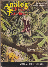
Analog Science Fact & Fiction, June 1961 (Volume 67, Number 4)
by John W. Campbell; Leigh Richmond; Lloyd Biggle, Jr.; L. Sprague de Camp; Philip E. High; Clifford D. Simak; George Willard
- Used
- Paperback
- Condition
- Used - Good+
- Binding
- Paperback
- Quantity Available
- 1
- Seller
-
Arlington, Virginia, United States
- Item Price
-
$5.95
Show Details
Description:
New York: Street & Smith Publications. June 1961. Digest-size Magazine. Good+.Edited by John W. Campbell. Cover art "Mutual indifference" by John Schoenherr. Includes "Prologue to an Analogue" (novelette) by Leigh Richmond; "Monument" (novelette, Hugo finalist) by Lloyd Biggle, Jr.; "Apollonios Enlists" by L. Sprague de Camp; "Fallen Angel" by Philip E. High; "The Fishermen" (aka "Time Is the Simplest Thing" Hugo finalist, serial, part 3 of 4) by Clifford D. Simak; "The Complex Problem of the Simple Weather Rocket" (Science Fact) by George Willard. Illustrated by Barberis, Douglas, Schoenherr, and Van Dongen.
Item Price
$5.95

Transcultural Leadership
by George F. Simons; Philip R. Harris; Carmen Vazquez
- Used
- Hardcover
- Condition
- Like New
- Binding
- Hardcover
- ISBN 10 / ISBN 13
- 9780872012998 / 0872012999
- Quantity Available
- 1
- Seller
-
Seattle, Washington, United States
- Item Price
-
$5.99
Show Details
Description:
Routledge, 1993. Hardcover. Like New. Pages are clean and are not marred by notes or folds of any kind. ~ ThriftBooks: Read More, Spend Less.Dust jacket quality is not guaranteed.
Item Price
$5.99