Description:
Russell, J. : A General Map of North America from the Best Authorities. Nd but ca.1800. From "A New Geographical, Historical and Commercial Grammar and Present State of Several Kingdoms of the World." Copper engraving. Size approx 200 x 230mm. Two neat folds. Some age colouring to edges, otherwise very clean and bright.
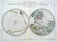
Les Deux Poles, Septentrional et Meridional, Sanson, 1679 by Nicolas Sanson - 1679
by Nicolas Sanson
Similar copies are shown below.
Similar copies are shown to the right.

Les Deux Poles, Septentrional et Meridional, Sanson, 1679
by Nicolas Sanson
- Used
- good
- first
Sanson, Nicolas. Paris 1679. [ Arctic and Antarctic ]. Les Deux Poles . Arctique ou Septentrional, et Antarcticque ou Meridional, ou Description des Terres Arcticques et Antarctiques; et des Pays circomvoisins jusques aux 45 Degres de Latitude. Par N. Sanson d'Abbeville Geographe ordre du Roy. Louvre Galleries, engraved by Pruthenus. Size approx 540mm x 410 mm. A double hemisphere map showing the North and South poles. The North pole is linked to Greenland and Spitzbergen but there is little other detailed coastline in the Arctic area. The most southerly part of South America is shown, together who the large land mass [Terra Incognita] which encompasses the bulk of the hemisphere. Central fold, with a slight barely visible paper defect in the lower left corner, not affecting any printed area. Very good condition.
-
Seller
Roz Hulse
 (GB)
(GB)
- Illustrator engraved by Pruthenus
- Format/Binding Map
- Book Condition Used - Good
- Quantity Available 1
- Publisher Par N. Sanson d'Abbeville Geographe ordre du Roy. Louvre Galleries,
- Place of Publication France
- Date Published 1679
- Keywords Sanson Map of the Poles
We have 1 copies available starting at $1,500.00.

North America from the Best Authorities, Russell, ca.1800
by Russell
- Used
- Condition
- Used
- Quantity Available
- 1
- Seller
-
Plymouth, Devon, United Kingdom
- Item Price
-
$25.12
Show Details
Item Price
$25.12

Sea Chart Portland to the Lizard. De Custe van Engelant tußchen Poortlant en Lezard [Sea Chart Portland to the Lizard]. Jacob Aertsz Colomb. Ca1640: Sea Chart Portland to the Lizard.
by Jacob Aertsz Colomb
- Used
- Condition
- Used
- Quantity Available
- 1
- Seller
-
Plymouth, Devon, United Kingdom
- Item Price
-
$226.10
Show Details
Description:
Colomb, Jacob Aertsz. De Custe van Engelant tußchen Poortlant en Lezard. Additional title: Les Costes d'Angleter re de Fierleij jusques á Lezard. Ca 1640. Listed in the The New Fierie Sea-Colomne from 1633-1651. Copper engraved, early hand coloured chart. Chart size approx 525mm x 375mm. Orientation NNE top centre cartouche contains scale. Decorative title cartouche to upper right and additional title cartouche below scales. Chart covers land areas from Portland to the Lizard. Among the places indicated on the coast line are Bridport, Torbay, Dartmouth, Plymouth, Fowey and Truro. Decorative compass rose, rhumb lines and sea vessel on sea area, which also includes the Ideston [Eddystone] Rock and the Kasquettes [Casquets] . Side margins tight with small breaks just touching edge of engraved area. One tear in sea area, repaired. Very early handwritten note to top margin, commenting on the soundings of this area and that of Falmouth, suggesting this chart had been used as a working reference at…
Read More Item Price
$226.10

Netherlands. Greenville Collins. 1753: Original 18th Century, Hand Coloured Sea Chart. Coast line of Flanders at Calles [Calais] to Der Scheling [Terschelling]of the West Frisian Islands and then Eastern England Margate in Kent to Burnham Flats in Norfolk. Much detail is given of the Thames es
by Greenville Collins
- Used
- very good
- Condition
- Used - Very Good
- Quantity Available
- 1
- Seller
-
Plymouth, Devon, United Kingdom
- Item Price
-
$226.10
Show Details
Description:
Collins, Capt. Greenville: Netherlands, Untitled chart of Holland, Flanders and Eastern England. Ca 1753. Copper engraved chart. Size approx 600mm x 480mm. Good margins, hand coloured, good impression on heavy paper. Coast line of Flanders at Calles [Calais] to Der Scheling [Terschelling]of the West Frisian Islands and then Eastern England Margate in Kent to Burnham Flats in Norfolk. Much detail is given of the Thames estuary and Rotterdam soundings. Depth soundings and rhumb lines indicated. A compass rose is set at the centre of the Chart. Title cartouche "To the Honourable Sir john Ashby Kt. Admiral of the Blew/ This is most humbly dedicated and presented by Capt G Collins". Some age soiling to edges, one small tear, without loss and repaired to centre fold area. A scarce, attractive sea chart in good, bright condition suitable for display.
Item Price
$226.10

Original Antique Map of Cheshire
by John Cary
- Used
- good
- Condition
- Used - Good
- Quantity Available
- 1
- Seller
-
Plymouth, Devon, United Kingdom
- Item Price
-
$50.24
Show Details
Description:
Cary, John: A Map of Cheshire. John Stockdale 26th March 1805. Engraved by J Cary 43x 53cm. Uncoloured. Two vertical folds. Some age toning on map, otherwise good strong print with great detail and accuracy. Excellent condition.
Item Price
$50.24
![Sea Chart. Duynckercke [Dunkirk].](https://d3525k1ryd2155.cloudfront.net/h/721/019/192019721.0.m.jpg)
Sea Chart. Duynckercke [Dunkirk].: Original Antique Hand coloured, copper engraved sea-chart.
by Pitt, Moses and Swart, Stephaman
- Used
- very good
- first
- Condition
- Used - Very Good
- Quantity Available
- 1
- Seller
-
Plymouth, Devon, United Kingdom
- Item Price
-
$251.22
Show Details
Description:
Pitt, Moses and Swart, Stephaman. Duynckercke, [Dunkirk]. Ca 1683. Hand coloured, copper engraved sea-chart. Chart size 440 x 505 mm, sheet size 580mm x 690mm. Two charts on one sheet showing the Dunkirk approaches. The larger chart from that of Blaeu's Pourtraict de la fameuse ville et havre de Duynckercke. With Rhumb lines, compass rose and scales. Townships and sandbanks indicated. Decorated with fleets of galleons off shore. With an inset panorama of Duynckercke [Dunkirk] after Jan Van Loon and a smaller coastal profile of Cales. The smaller chart showing the coast of Flanders, from Walchren [ Walcheren ] to Boloigne. Early hand coloured charts with later red ruled border on wide blank margins. Small tear without loss to lower blank margin, otherwise in bright and clean condition. Rare and attractive Sea Charts.
Item Price
$251.22
North America from the Best Authorities, Russell, ca.1800
by Russell
- Used
- Condition
- Used
- Quantity Available
- 1
- Seller
-
Plymouth, Devon, United Kingdom
- Item Price
-
$25.12
Show Details
Description:
Russell, J. : A General Map of North America from the Best Authorities. Nd but ca.1800. From "A New Geographical, Historical and Commercial Grammar and Present State of Several Kingdoms of the World." Copper engraving. Size approx 200 x 230mm. Two neat folds. Some age colouring to edges, otherwise very clean and bright.
Item Price
$25.12
Sea Chart Portland to the Lizard. De Custe van Engelant tußchen Poortlant en Lezard [Sea Chart Portland to the Lizard]. Jacob Aertsz Colomb. Ca1640: Sea Chart Portland to the Lizard.
by Jacob Aertsz Colomb
- Used
- Condition
- Used
- Quantity Available
- 1
- Seller
-
Plymouth, Devon, United Kingdom
- Item Price
-
$226.10
Show Details
Description:
Colomb, Jacob Aertsz. De Custe van Engelant tußchen Poortlant en Lezard. Additional title: Les Costes d'Angleter re de Fierleij jusques á Lezard. Ca 1640. Listed in the The New Fierie Sea-Colomne from 1633-1651. Copper engraved, early hand coloured chart. Chart size approx 525mm x 375mm. Orientation NNE top centre cartouche contains scale. Decorative title cartouche to upper right and additional title cartouche below scales. Chart covers land areas from Portland to the Lizard. Among the places indicated on the coast line are Bridport, Torbay, Dartmouth, Plymouth, Fowey and Truro. Decorative compass rose, rhumb lines and sea vessel on sea area, which also includes the Ideston [Eddystone] Rock and the Kasquettes [Casquets] . Side margins tight with small breaks just touching edge of engraved area. One tear in sea area, repaired. Very early handwritten note to top margin, commenting on the soundings of this area and that of Falmouth, suggesting this chart had been used as a working reference at…
Read More Item Price
$226.10
Netherlands. Greenville Collins. 1753: Original 18th Century, Hand Coloured Sea Chart. Coast line of Flanders at Calles [Calais] to Der Scheling [Terschelling]of the West Frisian Islands and then Eastern England Margate in Kent to Burnham Flats in Norfolk. Much detail is given of the Thames es
by Greenville Collins
- Used
- very good
- Condition
- Used - Very Good
- Quantity Available
- 1
- Seller
-
Plymouth, Devon, United Kingdom
- Item Price
-
$226.10
Show Details
Description:
Collins, Capt. Greenville: Netherlands, Untitled chart of Holland, Flanders and Eastern England. Ca 1753. Copper engraved chart. Size approx 600mm x 480mm. Good margins, hand coloured, good impression on heavy paper. Coast line of Flanders at Calles [Calais] to Der Scheling [Terschelling]of the West Frisian Islands and then Eastern England Margate in Kent to Burnham Flats in Norfolk. Much detail is given of the Thames estuary and Rotterdam soundings. Depth soundings and rhumb lines indicated. A compass rose is set at the centre of the Chart. Title cartouche "To the Honourable Sir john Ashby Kt. Admiral of the Blew/ This is most humbly dedicated and presented by Capt G Collins". Some age soiling to edges, one small tear, without loss and repaired to centre fold area. A scarce, attractive sea chart in good, bright condition suitable for display.
Item Price
$226.10
Original Antique Map of Cheshire
by John Cary
- Used
- good
- Condition
- Used - Good
- Quantity Available
- 1
- Seller
-
Plymouth, Devon, United Kingdom
- Item Price
-
$50.24
Show Details
Description:
Cary, John: A Map of Cheshire. John Stockdale 26th March 1805. Engraved by J Cary 43x 53cm. Uncoloured. Two vertical folds. Some age toning on map, otherwise good strong print with great detail and accuracy. Excellent condition.
Item Price
$50.24
Sea Chart. Duynckercke [Dunkirk].: Original Antique Hand coloured, copper engraved sea-chart.
by Pitt, Moses and Swart, Stephaman
- Used
- very good
- first
- Condition
- Used - Very Good
- Quantity Available
- 1
- Seller
-
Plymouth, Devon, United Kingdom
- Item Price
-
$251.22
Show Details
Description:
Pitt, Moses and Swart, Stephaman. Duynckercke, [Dunkirk]. Ca 1683. Hand coloured, copper engraved sea-chart. Chart size 440 x 505 mm, sheet size 580mm x 690mm. Two charts on one sheet showing the Dunkirk approaches. The larger chart from that of Blaeu's Pourtraict de la fameuse ville et havre de Duynckercke. With Rhumb lines, compass rose and scales. Townships and sandbanks indicated. Decorated with fleets of galleons off shore. With an inset panorama of Duynckercke [Dunkirk] after Jan Van Loon and a smaller coastal profile of Cales. The smaller chart showing the coast of Flanders, from Walchren [ Walcheren ] to Boloigne. Early hand coloured charts with later red ruled border on wide blank margins. Small tear without loss to lower blank margin, otherwise in bright and clean condition. Rare and attractive Sea Charts.
Item Price
$251.22
Les Deux Poles, Septentrional et Meridional, ou Description des Terres Arcticques et Antarctiques; et des Pays circomvoisins jusques aux 45 Degres de Latitude
by Sanson, Nicolas. [Antarctic & Arctic Map]
- Used
- Condition
- Used
- Quantity Available
- 1
- Seller
-
Garrison, New York, United States
- Item Price
-
$1,500.00
Show Details
Description:
Paris, 1657. Par N. Sanson d'Abbeville Geographe ordre du Roy... Spence 3017 lists a slightly different title but undoubtedly the same map. 53x38 cms. Period outline color, central fold, very good condition. A double hemisphere map to the North and South poles. The North pole is connected to Greenland and Spitzbergen but there is little other detailed coastline in the polar area. Europe, Russia and Canada are delineated. The South pole is based on the great unknown Southland of Magellan. The tip of S. America is shown, and a large land mass which encompasses the whole of the hemisphere, but nothing else.
Item Price
$1,500.00

More Photos
The Sky and the Forest
by Forester, C.S
- Used
- very good
- Hardcover
- first
- Condition
- Used - Very Good
- Jacket Condition
- Very Good
- Edition
- First Edition
- Binding
- Hardcover
- Quantity Available
- 1
- Seller
-
Salem, Oregon, United States
- Item Price
-
$34.89$20.93Save $13.96!
Show Details
Description:
C.S. Forester: The Sky and the Forest. Little, Brown and Company, Boston. Stated First Edition First Printing Thus August, 1948. Cover price $2.75. Used. VG BOOK/VG UNCLIPPED DUST JACKET. A story of a central Africa. By C.S. Forester, author of the Admiral Hornblower series.
Item Price
$34.89$20.93
Save $13.96
!
![Alaska and Klondike Region; [With inset of Klondike Region on the Upper Yukon detail] [From an...](https://d3525k1ryd2155.cloudfront.net/h/062/537/1339537062.0.m.jpg)
Alaska and Klondike Region; [With inset of Klondike Region on the Upper Yukon detail] [From an atlas, "Gazetteer of Alaska and Yukon Region " pp. 105 and 106]
by Miller, J. Martin
- Used
- very good
- Condition
- Used - Very Good
- Edition
- Unknown
- Quantity Available
- 1
- Seller
-
Sebastopol, California, United States
- Item Price
-
$39.00
Show Details
Description:
Chicago: J. Martin Miller, 1899. Unknown. Map. Very Good. [Map copyright 1899, printing date of Atlas later] [19.875x15.125in]; Colored map of Alaska with steamer routes from Portland and Seattle, insets of the Klondike Region on the Upper Yukon and Western portion of Aleutian Islands; On verso index of places and names with two large black and white images; Age toning to all edges, water stain marks on bottom, slight printing offset of colors, small chips and closed tears to lower edge;.
Item Price
$39.00

Zemepis Sveta - Monsunova Asie
by De La Blache, P. Vidal; Gallois, L
- Used
- Hardcover
- Condition
- Used - Very Good Condition
- Jacket Condition
- No Dust Jacket
- Binding
- Hardcover
- Quantity Available
- 1
- Seller
-
Oak Point, Texas, United States
- Item Price
-
$60.00
Show Details
Description:
Aventinum, Prague, Czechoslovakia, 1931. Hardcover. Very Good Condition/No Dust Jacket. Text entirely in Czech. Geography book on Asia with numerous photographs and maps. 1930 edition also available. Size: 4mo - over 9 3/4" - 12" tall. 400 pp. Pages are yellowed, but are tight and clean. Moderate shelfwear along the spine. Corners are lightly bumped. Quantity Available: 1. Shipped Weight: 3-5 pounds. Category: Travel & Places; Non-English Language::Czech; Pictures of this item not already displayed here available upon request. Inventory No: 001228. . Additional shipping charges may apply.
Item Price
$60.00

Zemepis Sveta - Monsunova Asie
by De La Blache, P. Vidal; Gallois, L
- Used
- Hardcover
- Condition
- Used - Very Good Condition
- Jacket Condition
- No Dust Jacket
- Binding
- Hardcover
- Quantity Available
- 1
- Seller
-
Oak Point, Texas, United States
- Item Price
-
$60.00
Show Details
Description:
Aventinum, Prague, Czechoslovakia, 1930. Hardcover. Very Good Condition/No Dust Jacket. Text entirely in Czech. Geography book on Asia with numerous photographs and maps. 1931 edition also available. Size: 4mo - over 9 3/4" - 12" tall. 400 pp. Pages are yellowed, but are tight and clean. Moderate shelfwear along the spine. Corners are lightly bumped. Quantity Available: 1. Shipped Weight: 3-5 pounds. Category: Travel & Places; Non-English Language::Czech; Pictures of this item not already displayed here available upon request. Inventory No: 001227. . Additional shipping charges may apply.
Item Price
$60.00
North America from the Best Authorities, Russell, ca.1800
by Russell
- Used
- Condition
- Used
- Quantity Available
- 1
- Seller
-
Plymouth, Devon, United Kingdom
- Item Price
-
$25.12
Show Details
Description:
Russell, J. : A General Map of North America from the Best Authorities. Nd but ca.1800. From "A New Geographical, Historical and Commercial Grammar and Present State of Several Kingdoms of the World." Copper engraving. Size approx 200 x 230mm. Two neat folds. Some age colouring to edges, otherwise very clean and bright.
Item Price
$25.12

Asia from the Best Authorities, Russell, ca.1800
by Russell
- Used
- Condition
- Used
- Quantity Available
- 1
- Seller
-
Plymouth, Devon, United Kingdom
- Item Price
-
$25.12
Show Details
Description:
Russell, J. : Asia from the Best Authorities. Nd but ca.1800. From "A New Geographical, Historical and Commercial Grammar and Present State of Several Kingdoms of the World". Copper engraving. Size approx 200 x 230mm. Two neat folds. Some age colouring to edges, otherwise clean and bright. Includes Arabia, India, Borneo, Japan, China and eastern Russia.
Item Price
$25.12
![MAP OF UTAH [Territory]](https://d3525k1ryd2155.cloudfront.net/h/836/461/1485461836.0.m.jpg)
More Photos
MAP OF UTAH [Territory]
- Used
- Condition
- Used - Very Good-
- Edition
- Original
- Quantity Available
- 1
- Seller
-
Williamsburg, Virginia, United States
- Item Price
-
$65.00
Show Details
Description:
New York, Richmond, Chicago, & Toledo: H. H. Hardesty, 1885. Original color lithographed map printed by Rand, McNally & Company, Engravers and published in HARDESTY'S HISTORICAL AND GEOGRAPHICAL ENCYCLOPEDIA: SPECIAL VIRGINIA EDITION. 19 3/8 inches by 13 1/4 inches on a 21" X 14 1/2" sheet. The map depicts the Territory of Utah in its final form--large areas had been removed and ceded to Nevada, Colorado, Wyoming, and Nebraska since Utah became a U. S. Territory in 1850. The issue of polygamy prevented statehood until it was finally granted in 1896. This map features railroads and topography and uses color to set off counties from each other. Unlike most atlas maps of the period, this map identifies most small towns. The map is guaranteed to be moe than 135 years old. The map is in about very good condition: generally clean and bright, with slight toning of paper and one faint water stain near the center-left edge of the map.. Original. Single Sheet. Very Good-. Elephant…
Read More Item Price
$65.00

Philips Special Map of the Nile, The Advance on Khartum and the Environs of Omdurman. Cc1900
by George Philips and Son,
- Used
- Condition
- Used
- Quantity Available
- 1
- Seller
-
Plymouth, Devon, United Kingdom
- Item Price
-
$32.66
Show Details
Description:
Philips Special map of the Nile illustrating the Advance on Khartum [Khartoum] with an enlargement of the environs of Omdurman [Omdur]. George Philips and Son, London and Liverpool Ca 1900. 580mm x 900mm folded map. Front title wrapper has come loose, not affecting map area. Three maps are displayed within the sheet. Map1. Map of the Nile Valley 520mm x 300mm showing the approaches of Khartum. Scale 1inch to 100 Geographical miles. Coloured indicating Possessions and Protectorates of European Powers. Map 2. Special map of the Nile from Dongola to Khartum. Scale 16 miles to the inch. Coloured. In set in this map is Map3. Environs of Omdurman, Scale 5 statute miles to the inch. Some small breaks at some folds, not affecting imagery or use of map. Title label is damaged, the map is clean and bright, probably unused. A very interesting record.
Item Price
$32.66

Last Tales
by Dinesen, Isak
- Used
- very good
- Hardcover
- first
- Condition
- Used - Very Good
- Jacket Condition
- Good+
- Edition
- First Edition
- Binding
- Hardcover
- Quantity Available
- 1
- Seller
-
Salem, Oregon, United States
- Item Price
-
$120.00$72.00Save $48.00!
Show Details
Description:
Dinesen, Isak: Last Tales, A Collection of Twelve New Tales of Compelling Beauty 1957, Random House. First Edition. Stated First Printing Thus. Used. Very Good/Good+ original red dust jacket, price-clipped. Jacket states 11/57 on front flap. 5 3/4 X
Item Price
$120.00$72.00
Save $48.00
!

The Adventure of Wrangel Island
by Vilhjalmur Stefansson
- Used
- good
- Hardcover
- first
- Condition
- Used - Good
- Jacket Condition
- No DJ Included
- Edition
- First Edition
- Binding
- Hardcover
- Quantity Available
- 1
- Seller
-
Salem, Oregon, United States
- Item Price
-
$124.89$74.93Save $49.96!
Show Details
Description:
The Adventure of Wrangel Island, Alaska (1925 Macmillan 1st Edition) HISTORY OF ALASKA. EXLIB. Good Condition/ No DJ included. Fold-out map affixed to binding at the back of the book has never been opened. The story of the (unsuccessful) attempted colonization of Wrangel Island Alaska. 413 pages plus appendix, Index. Titling is still bright. A clean, solid copy. Scarce.
Item Price
$124.89$74.93
Save $49.96
!