Click for full-size.
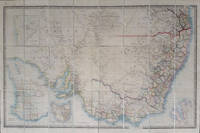
South Australia. Map of South Australia, New South Wales, Van Diemens Land and Settled Parts of Australia, with plans of the City of Sydney, and of the town of Adelaide
by Wyld, James
- Used
- Condition
- See description
- Seller
-
Garrison, New York, United States
Payment Methods Accepted
About This Item
Charing Cross East, London: James Wyld, 1854. Maps. The map extends from Wide Bay in the north to Wilsons Promontory in the south. Insets of Adelaide, Western Australia, Van Dieman's Land, and Sydney. The title on the map is: Map of South Australia, New South Wales, Van Diemens Land and Settled Parts of Australia. Dedicated to Major Sir T. L. Mitchell ... surveyor of New South Wales. The map shows both Australia Felix and Victoria and includes Gold Deposits and Railroads; the northern border of New South Wales shown. Folded, dissected and mounted on linen, fresh and clean. With the original dark green slipcase with white and gray label with black decorative floral border; very good. Slipcase rubbed at corners, marked on verso; later spine label partially torn away. Tooley 1420 without publication date. Trove has 5 entries from 1838 until 1851 (41236330), but not this later copy. Map in original outline color, 38 1/2 x 26 1/4". Very good.
Reviews
(Log in or Create an Account first!)
Details
- Seller
- Antipodean Books, Maps & Prints
 (US)
(US)
- Seller's Inventory #
- 16611
- Title
- South Australia. Map of South Australia, New South Wales, Van Diemens Land and Settled Parts of Australia, with plans of the City of Sydney, and of the town of Adelaide
- Author
- Wyld, James
- Format/Binding
- Maps
- Book Condition
- Used
- Quantity Available
- 1
- Publisher
- James Wyld
- Place of Publication
- Charing Cross East, London
- Date Published
- 1854
- Bookseller catalogs
- QUEENSLAND; MAPS; AUSTRALIA; SOUTH AUSTRALIA;
Terms of Sale
Antipodean Books, Maps & Prints
30 day return guarantee, with full refund including shipping costs for up to 10 days after delivery if an item arrives mis-described or damaged.
About the Seller
Antipodean Books, Maps & Prints
Biblio member since 2009
Garrison, New York
About Antipodean Books, Maps & Prints
Booksellers for over 40 years, members of prominent trade associations (ABAA, ILAB, ANZAAB, IMCOS, ANZMS, PBFA). We are located at Garrison NY, a stone's throw from the Metro North Hudson line train, just over 1 hr. from NYC on the banks of the Hudson River. Books, maps, prints & ephemera bought & sold.
Glossary
Some terminology that may be used in this description includes:
- New
- A new book is a book previously not circulated to a buyer. Although a new book is typically free of any faults or defects, "new"...
- Spine Label
- The paper or leather descriptive tag attached to the spine of the book, most commonly providing the title and author of the...
This Book’s Categories

What is a professional bookseller?
Just about anyone can sell a book, but a professional bookseller knows the ins and outs of the rare book trade. Learn more!

What did people buy in 2020?
Plague journals, escapist literature, political history: explore our year in review, where we share rare book trends and a gallery of some of the most beautiful and interesting books sold in 2020.