Description:
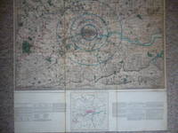
London, c. 1841. Copper engraved folding map of London and environs, 87 x 83 cm, engraved by Alexander Findlay, original hand colour, dissected into 24 panels and laid on linen, somewhat stained on the verso, and folding into original cloth slipcase with publisher’s printed label, somewhat worn. The map extends between Ware and Chatham, Bray and Dorking. The concentric rings mark a radius of 3, 5, 7 and 12 miles from Charings Cross, and can be used in conjunction with the key map and text at the foot to calculate cab fares and postage rates, distances and delivery times. In his carto-bibliography Howgego does not mention that a variant of this map was issued under the imprint of publisher John Lingard, or that it was adapated to calculate cab fares or the twopenny post - that seems to have been Lingard’s idea. However, Howgego does record that a revised version was issued by Laurie in 1841, and in the same year Lingard issued his own versio of Laurie’s map of central London. Internal…
Read More Survey of the Country Around London. To the Distance of Thirty-Two Miles from St. Pauls by LINGARD, John
by LINGARD, John
Similar copies are shown below.
Similar copies are shown to the right.
Survey of the Country Around London. To the Distance of Thirty-Two Miles from St. Pauls
by LINGARD, John
- Used
- near fine
(London): John Lingard. Map. Near Fine. c1844. Large folding hand coloured map mounted on linen, dissecting in sixteen sections. Extends from Ware to Dorking and from Maidenhead Bridge to Chatham. Size : 620 x 795 mm. With attached, "Lingard's Miniature map and key extending 12 miles round London". In slipcase with printed paper title label on the upper cover. Also with hackney and postal details. Boyle, 164
-
Seller
Independent bookstores
 (GB)
(GB)
- Format/Binding Map
- Book Condition Used - Near Fine
- Quantity Available 1
- Publisher John Lingard
- Place of Publication (London)
- Keywords London. London Maps. Maps. London Plans. Cartogrphy. Folding Maps. CATX100
We have 1 copies available starting at $944.93.

Survey of the country around London to the distance of thirty two miles from St Paul’s.
by Laurie, Richard Holmes; Lingard, John:
- Used
- Hardcover
- Condition
- Used
- Binding
- Hardcover
- Quantity Available
- 1
- Seller
-
London, United Kingdom
- Item Price
-
$944.93
Show Details
Item Price
$944.93