Description:
Gale, Sabin Americana, 2012-02-22. Paperback. Good.
The United States Gazetteer: containing an Authentic description of the Several States. Their situation, extent, boundaries, soil, produce, climate, population, trade and manufactures. Together with the Extent, boundarires and population of their Respecti by SCOTT, Joseph
by SCOTT, Joseph
Similar copies are shown below.
Similar copies are shown to the right.
The United States Gazetteer: containing an Authentic description of the Several States. Their situation, extent, boundaries, soil, produce, climate, population, trade and manufactures. Together with the Extent, boundarires and population of their Respecti
by SCOTT, Joseph
- Used
- first
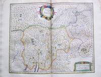
Philadelphia: F. and R. Bailey, 1795 [but 1794].. 12mo (6 4/8 x 4 inches). Engraved title-page. Engraved folding frontispiece map of the United States (small tear at the gutter), and 18 folding maps of Connecticut, Delaware, Georgia, New Jersey, Kentucky, Maine, Maryland, Massachusetts, New Hampshire, New York, North Carolina, Pennsylvania, Rhode Island, South Carolina, Northwest Territory, Southwest Territory, Vermont and Virginia (some offsetting, some browning). Contemporary tree calf red morocco lettering-piece (rebacked to style, extremities bumped). Provenance: Contemporary ownership inscription of Dr. Alfred Whelen Paris, France, dated August 18th 1874 on front free endpaper, with his faint penciled signature on the title-page. "The maps I have drawn and engraved myself" (Scott "Preface") First edition of the first Gazetteer of the United States, with an early ownership inscription confirming the date of publication to be 1794 rather than 1795 as on the title-page. Philadelphia engraver and publisher Joseph T. Scott, along with fellow Philadelphian Mathew Carey, was one of the first American cartographic publishers: "The maps I have drawn and engraved myself, and I trust they will be found, on examination, as accurate as circumstances would admit, and probably more so than any collection of maps that has hitherto been published in the United States" (Scott "Preface"). Scott's gazetteer includes some of the most important early maps of the new "western" territories, as well as quite accurate depictions of the developing eastern states. Evans 29476; Sabin 78331; Howes S237. Catalogued by Kate Hunter .
-
Bookseller
Arader Galleries
 (US)
(US)
- Book Condition Used
- Publisher Philadelphia: F. and R. Bailey, 1795 [but 1794]..
We have 7 copies available starting at $6.33.

Stock Photo: Cover May Be Different
The United States gazetteer: containing an authentic description of the several states, their situation, extent, boundaries, soil, produce, climate, ... extent, boundaries and population of their..
by Joseph Scott
- Used
- good
- Paperback
- Condition
- Used - Good
- Binding
- Paperback
- ISBN 10 / ISBN 13
- 9781275791053 / 1275791050
- Quantity Available
- 1
- Seller
-
HOUSTON, Texas, United States
- Item Price
-
$6.33
Show Details
Item Price
$6.33
Stock Photo: Cover May Be Different
The United States Gazetteer: Containing an Authentic Description of the Several States, Their Situation, Extent, Boundaries, Soil, Produce, Climate, Population, Trade and Manufactures: Together with the Extent, Boundaries and Population of Their...
by Joseph Scott
- New
- Paperback
- Condition
- New
- Binding
- Paperback
- ISBN 10 / ISBN 13
- 9781275791053 / 1275791050
- Quantity Available
- 10
- Seller
-
Southport, Merseyside, United Kingdom
- Item Price
-
$31.28
Show Details
Description:
Paperback. New.
Item Price
$31.28

More Photos
The United States Gazetteer: Containing an Authentic Description of the Several States. Their Situation, Extent, Boundaries, Soil, Produce, Climate, Population, Trade and Manufactures. Together with the Extent, Boundaries and Population of their Respective Counties. Also, an Exact Account of the Cities, Towns, Harbours, Rivers, Bays, Lakes, Mountains, &c
by SCOTT, Joseph
- Used
- Condition
- Used
- Quantity Available
- 1
- Seller
-
New York, New York, United States
- Item Price
-
$5,750.00
Show Details
Description:
Philadelphia: F. and R. Bailey, 1795. 12mo. (6 3/8 x 3 3/4 inches). Engraved title, [iii]-vi, errata leaf, blank leaf, [292]pp. 19 engraved folding maps. Expertly bound to style in period tree sheep, flat spine, gilt, red morocco lettering piece. The first gazetteer of the United States with an important series of engraved American maps: an American cartographic cornerstone. These, with the maps in Carey's American Atlas that were issued the same year, represent a major step forward in American cartography. Scott's maps cover the United States in general, Connecticut, Delaware, Georgia, New Jersey, Kentucky, Maine, Maryland, Massachusetts, New Hampshire, New York, North Carolina, Pennsylvania, Rhode Island, South Carolina, Vermont, Virginia, the Northwest Territory, and the Southwest Territory. An important early work of U.S. cartography and among the earliest mappings of each state. Clark III:123; Evans 29476; Howes S237; Sabin 78331; Wheat & Brun 125.
Item Price
$5,750.00

United States Gazetteer: Containing an Authentic Description
by SCOTT, Joseph
- Used
- Condition
- Used
- Quantity Available
- 1
- Seller
-
Bryn Mawr,, Pennsylvania, United States
- Item Price
-
$6,000.00
Show Details
Description:
1795. SCOTT, Joseph. The United States Gazetteer: Containing an Authentic Description of the Several States. Their Situation, Extent, Boundaries, Soil, Produce, Climate, Population, Trade and Manufactures. Together with the Extent, Boundaries and Population of Their Respective Counties. Also, An Exact Account of the Cities, Towns, Harbours, Rivers, Bays, Lakes, Mountains, &c. Philadelphia: F. and R. Bailey, 1795. Engraved title, [iii]-vi, errata leaf, blank leaf, [292]pp. Nineteen engraved folding maps. 12mo. Antique style 3/4 speckled calf and marbled boards, raised spine bands, gilt decorated spine, red morocco spine label Frontispiece map neatly repaired (with losses along vertical folds), the other maps are all in very good condition, light scattered foxing, else very good. HOWES S-237, "aa." Sabin 78331. Evans 29476. Clark III:123. Wheat & Brun 125.The first gazetteer of the United States with an important series of engraved American maps. These, with the maps in Carey's AMERICAN ATLAS that were…
Read More Item Price
$6,000.00
THE UNITED STATES GAZETTEER: DESCRIPTION CONTAINING AN AUTHENTIC DESCRIPTION OF THE SEVERAL STATES THEIR SITUATION, EXTENT, BOUNDARIES, SOIL, PRODUCE, CLIMATE, POPULATION, TRADE AND MANUFACTURES : Together with the extent, boundaries and population of their respective counties. Also, an exact account of the cities, towns, harbours, rivers, bays, lakes, mountains, &c. : Illustrated with nineteen maps
by Scott, Joseph
- Used
- Hardcover
- Condition
- Used
- Binding
- Hardcover
- Quantity Available
- 1
- Seller
-
Chevy Chase, Maryland, United States
- Item Price
-
$6,500.00
Show Details
Description:
Philadelphia: Printed by F. and R. Bailey at Yorick's-Head, No. 116, High Street, 1795. First edition of the first American gazetteer. 12mo. vi, (2), [292] pp. [printed double-column]. Engraved title page, engraved folding map of the United States as frontispiece and 18 other engraved folding maps for Connecticut, Delaware, Georgia, New Jersey, Kentucky, Maine, Maryland, Massachusetts, New Hampshire, New York, North Carolina, Pennsylvania, Rhode Island, South Carolina, Northwest Territory, Southwest Territory, Vermont, and Virginia. Bookplate and 1800 ownership signature of William Rogers. Howes S-237. Sabin 78331. Evans 29476. Clark Old South II, 122. Wheat & Brun 125. Sowerby "Library of Thomas Jefferson" 4022: "My account of the caves and minerals in Virginia, I have taken from Mr. Jefferson's notes on that state, and a few particulars relating to the rivers." Old tape shadows on endpapers, but a very good copy, the maps crisp, in an attractive new binding by Phil Dusel. Recent period-style calf,…
Read More Item Price
$6,500.00

More Photos
THE UNITED STATES GAZETTEER: CONTAINING AN AUTHENTIC DESCRIPTION OF THE SEVERAL STATES. THEIR SITUATION, EXTENT, BOUNDARIES, SOIL, PRODUCE, CLIMATE, POPULATION, TRADE AND MANUFACTURES. TOGETHER WITH THE EXTENT, BOUNDARIES AND POPULATION OF THEIR RESPECTIVE COUNTIES. ALSO, AN EXACT ACCOUNT OF THE CITIES, TOWNS, HARBOURS, RIVERS, BAYS, LAKES, MOUNTAINS, &c
by Scott, Joseph
- Used
- Hardcover
- Condition
- Used
- Binding
- Hardcover
- Quantity Available
- 1
- Seller
-
New Haven, Connecticut, United States
- Item Price
-
$7,500.00
Show Details
Description:
Philadelphia: F. and R. Bailey, 1795.. Engraved titlepage, [iii]-vi, errata leaf, blank leaf, [292]pp. Text printed in double columns. Nineteen engraved folding maps, including the large folding frontispiece map. 12mo. Contemporary tree sheep, red morocco label. Boards rubbed, mostly along the spine and edges. Two-inch closed tear in edge of frontispiece map (where bound in). Offsetting from the maps. Very good. The first gazetteer of the United States, with an important series of engraved American maps. These, with the maps in Carey's AMERICAN ATLAS that were issued the same year, represent a major step forward in American cartography. Scott's maps cover the United States in general, Connecticut, Delaware, Georgia, New Jersey, Kentucky, Maine, Maryland, Massachusetts, New Hampshire, New York, North Carolina, Pennsylvania, Rhode Island, South Carolina, Vermont, Virginia, the Northwest Territory, and the Southwest Territory. An important early work of U.S. cartography and among the earliest mappings…
Read More Item Price
$7,500.00

More Photos
The United States Gazetteer: Containing an Authentic Description of the Several States. Their Situation, Extent, Boundaries, Soil, Produce, Climate, Population, Trade and Manufactures. Together with the Extent, Boundaries and Population of their Respective Counties. Also, an Exact Account of the Cities, Towns, Harbours, Rivers, Bays, Lakes, Mountains, &c
by SCOTT, Joseph
- Used
- Condition
- Used
- Quantity Available
- 1
- Seller
-
New York, New York, United States
- Item Price
-
$8,000.00
Show Details
Description:
Philadelphia: F and R. Bailey, 1795. 12mo. (6 3/8 x 3 3/4 inches). Engraved title, [iii]-vi, errata leaf, blank leaf, [292]pp. Nineteen engraved folding maps, including the large folding frontispiece map (4 with hand colouring). Contemporary tree sheep, flat spine divided into compartments with gilt fillets, red morocco lettering piece in the second, repair to front joint. The first gazetteer of the United States with an important series of engraved American maps: an American cartographic cornerstone. These, with the maps in Carey's American Atlas that were issued the same year, represent a major step forward in American cartography. Scott's maps cover the United States in general, Connecticut, Delaware, Georgia, New Jersey, Kentucky, Maine, Maryland, Massachusetts, New Hampshire, New York, North Carolina, Pennsylvania, Rhode Island, South Carolina, Vermont, Virginia, the Northwest Territory, and the Southwest Territory. An important early work of U.S. cartography and among the earliest mappings of…
Read More Item Price
$8,000.00