Description:
USA: W.H. Stewart, 1889. Book. Very Good. Map. First Edition Thus. Folio - over 12" - 15" tall. Outside dimensions 10.75" x 14.5". Unmarked with light wear and soiling. An attractive vintage copy..
Search Results: Maps from RareNonFiction.com
You searched for:
- Subject: Maps from RareNonFiction.com
Results 1 - 20 of 287

1889 Color Map of Europe
by Cramm, Geo. F.
- Used
- very good
- first
- Condition
- Used - Very Good
- Edition
- First Edition Thus
- Quantity Available
- 1
- Seller
-
Ladysmith, British Columbia, Canada
- Item Price
-
$195.00$16.99 shipping to USA
Show Details
Item Price
$195.00
$16.99
shipping to USA
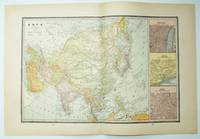
1889 Color Map of Asia, Including Expanded Views of Jerusalem, Canton and Delhi
by Cramm, Geo. F.
- Used
- very good
- first
- Condition
- Used - Very Good
- Edition
- First Edition Thus
- Quantity Available
- 1
- Seller
-
Ladysmith, British Columbia, Canada
- Item Price
-
$450.00$16.99 shipping to USA
Show Details
Description:
USA: W.H. Stewart, 1889. Book. Very Good. Map. First Edition Thus. Folio - over 12" - 15" tall. Outside dimensions 14.5" x 21.75". Unmarked with light wear and soiling. An attractive vintage copy..
Item Price
$450.00
$16.99
shipping to USA
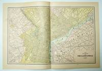
1889 Color Driving Map of Philadelphia, Pennsylvania (PA)
by Cram, Geo. F.
- Used
- very good
- first
- Condition
- Used - Very Good
- Edition
- First Edition Thus
- Quantity Available
- 1
- Seller
-
Ladysmith, British Columbia, Canada
- Item Price
-
$350.00$16.99 shipping to USA
Show Details
Description:
Rochester, NY: W.H. Stewart, 1889. Book. Illus. by Cram, Geo. F.. Very Good. Map. First Edition Thus. Folio - over 12" - 15" tall. Outer dimensions: 21.75" x 14.5". Includes many street names and locations of interest. Clean and unmarked with light wear. An attractive vintage copy..
Item Price
$350.00
$16.99
shipping to USA

1889 Color Map of the States of Virginia and West Virginia
by Cram, Geo. F.
- Used
- very good
- first
- Condition
- Used - Very Good
- Edition
- First Edition Thus
- Quantity Available
- 1
- Seller
-
Ladysmith, British Columbia, Canada
- Item Price
-
$149.95$16.99 shipping to USA
Show Details
Description:
Rochester, NY: W.H. Stewart, 1889. Book. Illus. by Cram, Geo. F.. Very Good. Map. First Edition Thus. Folio - over 12" - 15" tall. Vintage state map with counties individually colored. Outer dimensions: 21.75" x 14.5". Unmarked with light wear. Center fold. A quality example. Bonus: includes separate extensive list of counties and towns/cities for each state, indicating (1889) population of each..
Item Price
$149.95
$16.99
shipping to USA
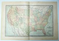
1889 Color Map of the Contiguous (Continental) United States of America (U.S.A.)
by Cram, Geo. F.
- Used
- good
- first
- Condition
- Used - Good
- Edition
- First Edition Thus
- Quantity Available
- 1
- Seller
-
Ladysmith, British Columbia, Canada
- Item Price
-
$750.00$16.99 shipping to USA
Show Details
Description:
Rochester, NY: W.H. Stewart, 1889. Book. Illus. by Cram, Geo. F.. Good. Map. First Edition Thus. Folio - over 12" - 15" tall. Vintage map with states individually colored. Of interest, modern day Oklohoma indicated as Indian Territory, and names such as Miami, Los Angeles and Seattle do not appear. Outer dimensions: 21.75" x 14.5". Unmarked with moderate wear. Center fold. 5" opening along top edge mended with archival tape..
Item Price
$750.00
$16.99
shipping to USA

1889 Color Map of the Eastern Half of the State of Texas
by Cram, Geo. F.
- Used
- very good
- first
- Condition
- Used - Very Good
- Edition
- First Edition Thus
- Quantity Available
- 1
- Seller
-
Ladysmith, British Columbia, Canada
- Item Price
-
$250.00$16.99 shipping to USA
Show Details
Description:
Rochester, NY: W.H. Stewart, 1889. Book. Illus. by Cram, Geo. F.. Very Good. Map. First Edition Thus. Folio - over 12" - 15" tall. Outer dimensions: 21.75" x 14.5". Counties individually colored. Clean and unmarked with light wear. An attractive vintage copy. Bonus: includes separate extensive list of Texas counties and cities/towns, complete with their (1889) populations..
Item Price
$250.00
$16.99
shipping to USA
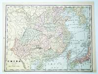
1889 Color Map of China, With Inset Map of Japan
by Cramm, Geo. F.
- Used
- very good
- first
- Condition
- Used - Very Good
- Edition
- First Edition Thus
- Quantity Available
- 1
- Seller
-
Ladysmith, British Columbia, Canada
- Item Price
-
$350.00$16.99 shipping to USA
Show Details
Description:
USA: W.H. Stewart, 1889. Book. Very Good. Map. First Edition Thus. Folio - over 12" - 15" tall. Outside dimensions 10.75" x 14.5". Unmarked with light wear and soiling. An attractive vintage copy..
Item Price
$350.00
$16.99
shipping to USA
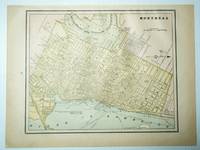
1889 Color Map of the City of Montreal, Quebec
by Cram, Geo. F.
- Used
- very good
- first
- Condition
- Used - Very Good
- Edition
- First Edition Thus
- Quantity Available
- 1
- Seller
-
Ladysmith, British Columbia, Canada
- Item Price
-
$150.00$16.99 shipping to USA
Show Details
Description:
Rochester, NY: W.H. Stewart, 1889. Book. Illus. by Cram, Geo. F.. Very Good. Map. First Edition Thus. Folio - over 12" - 15" tall. Outer dimensions: 10.75" x 14.5". Includes many street names and locations of interest. Clean and unmarked with light wear. An attractive vintage copy. Text in English..
Item Price
$150.00
$16.99
shipping to USA
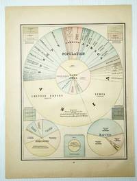
1889 Color Pie Charts of World Population By Country, Continent, Religion and Race
by Cram, Geo. F.
- Used
- very good
- first
- Condition
- Used - Very Good
- Edition
- First Edition Thus
- Quantity Available
- 1
- Seller
-
Ladysmith, British Columbia, Canada
- Item Price
-
$149.95$16.99 shipping to USA
Show Details
Description:
Rochester, NY: W.H. Stewart, 1889. Book. Illus. by Cram, Geo. F.. Very Good. Map. First Edition Thus. Folio - over 12" - 15" tall. Outer dimensions: 10.75" x 14.5". A fascinating and informative presentation of the population of the world in 1889. Main pie chart breaks illustrates the world's population by country and continent. Smaller pie charts present world population by religion and race. Clean and unmarked with light wear. A quality vintage copy..
Item Price
$149.95
$16.99
shipping to USA

1889 Color Map of the State of Louisiana
by Cram, Geo. F.
- Used
- very good
- first
- Condition
- Used - Very Good
- Edition
- First Edition Thus
- Quantity Available
- 1
- Seller
-
Ladysmith, British Columbia, Canada
- Item Price
-
$99.95$16.99 shipping to USA
Show Details
Description:
Rochester, NY: W.H. Stewart, 1889. Book. Illus. by Cram, Geo. F.. Very Good. Map. First Edition Thus. Folio - over 12" - 15" tall. Outer dimensions: 10.75" x 14.5". Counties individually colored. Clean and unmarked with light wear. An attractive vintage copy. Bonus: includes separate list of Louisiana counties and cities/towns, complete with their (1889) populations..
Item Price
$99.95
$16.99
shipping to USA
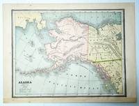
1889 Color Map of the State of Alaska
by Cram, Geo. F.
- Used
- very good
- first
- Condition
- Used - Very Good
- Edition
- First Edition Thus
- Quantity Available
- 1
- Seller
-
Ladysmith, British Columbia, Canada
- Item Price
-
$199.95$16.99 shipping to USA
Show Details
Description:
Rochester, NY: W.H. Stewart, 1889. Book. Illus. by Cram, Geo. F.. Very Good. Map. First Edition Thus. Folio - over 12" - 15" tall. Outer dimensions: 10.75" x 14.5". Unmarked with light wear. A quality vintage copy..
Item Price
$199.95
$16.99
shipping to USA
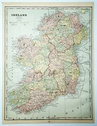
1889 Color Map of Ireland
by Cramm, Geo. F.
- Used
- very good
- first
- Condition
- Used - Very Good
- Edition
- First Edition Thus
- Quantity Available
- 1
- Seller
-
Ladysmith, British Columbia, Canada
- Item Price
-
$195.00$16.99 shipping to USA
Show Details
Description:
USA: W.H. Stewart, 1889. Book. Very Good. Map. First Edition Thus. Folio - over 12" - 15" tall. Outside dimensions 14.5" x 10.75". Counties individually coloured. Unmarked with light wear and soiling. An attractive vintage copy..
Item Price
$195.00
$16.99
shipping to USA
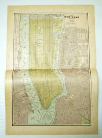
1889 Color Map of New York City (Manhattan) and Vicinity
by Cram, Geo. F.
- Used
- very good
- first
- Condition
- Used - Very Good
- Edition
- First Edition Thus
- Quantity Available
- 1
- Seller
-
Ladysmith, British Columbia, Canada
- Item Price
-
$500.00$16.99 shipping to USA
Show Details
Description:
Rochester, NY: W.H. Stewart, 1889. Book. Illus. by Cram, Geo. F.. Very Good. Map. First Edition Thus. Folio - over 12" - 15" tall. Outer dimensions: 21.75" x 14.5". Includes many street names, locations of interest, and list of steamships and their pier addresses. Clean and unmarked with light wear. An attractive vintage example of this marvelous Big Apple memento..
Item Price
$500.00
$16.99
shipping to USA

1889 Color Map of The Turkish Empire in Europe and Asia, Greece, Roumania, Etc.
by Cramm, Geo. F.
- Used
- very good
- first
- Condition
- Used - Very Good
- Edition
- First Edition Thus
- Quantity Available
- 1
- Seller
-
Ladysmith, British Columbia, Canada
- Item Price
-
$149.95$16.99 shipping to USA
Show Details
Description:
USA: W.H. Stewart, 1889. Book. Very Good. Map. First Edition Thus. Folio - over 12" - 15" tall. Outside dimensions 10.75" x 14.5". Unmarked with light wear and soiling. An attractive vintage copy..
Item Price
$149.95
$16.99
shipping to USA

1889 Color Map of the State of Wyoming
by Cram, Geo. F.
- Used
- very good
- first
- Condition
- Used - Very Good
- Edition
- First Edition Thus
- Quantity Available
- 1
- Seller
-
Ladysmith, British Columbia, Canada
- Item Price
-
$150.00$16.99 shipping to USA
Show Details
Description:
Rochester, NY: W.H. Stewart, 1889. Book. Illus. by Cram, Geo. F.. Very Good. Map. First Edition Thus. Folio - over 12" - 15" tall. Outer dimensions: 10.75" x 14.5". Counties individually colored. Clean and unmarked with light wear. One-inch opening to lower left edge. An attractive vintage copy. Bonus: includes separate list of Wyoming counties and cities/towns, complete with their (1889) populations..
Item Price
$150.00
$16.99
shipping to USA
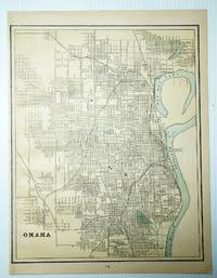
1889 Color Map of the City of Omaha, Nebraska (NE)
by Cramm, Geo. F.
- Used
- very good
- first
- Condition
- Used - Very Good
- Edition
- First Edition Thus
- Quantity Available
- 1
- Seller
-
Ladysmith, British Columbia, Canada
- Item Price
-
$99.95$16.99 shipping to USA
Show Details
Description:
USA: W.H. Stewart, 1889. Book. Very Good. Map. First Edition Thus. Folio - over 12" - 15" tall. Outside dimensions 14.5" x 10.75". Includes many street names. Unmarked with light wear and soiling. An attractive vintage copy..
Item Price
$99.95
$16.99
shipping to USA
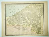
1889 Color City Map of Cleveland, Ohio (OH)
by Cram, Geo. F.
- Used
- very good
- first
- Condition
- Used - Very Good
- Edition
- First Edition Thus
- Quantity Available
- 1
- Seller
-
Ladysmith, British Columbia, Canada
- Item Price
-
$149.95$16.99 shipping to USA
Show Details
Description:
Rochester, NY: W.H. Stewart, 1889. Book. Illus. by Cram, Geo. F.. Very Good. Map. First Edition Thus. Folio - over 12" - 15" tall. Outer dimensions: 10.75" x 14.5". Includes many street names. Clean and unmarked with light wear. An attractive vintage copy..
Item Price
$149.95
$16.99
shipping to USA
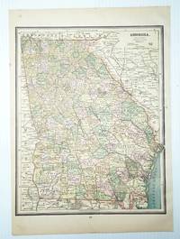
1889 Color Map of the State of Georgia
by Cram, Geo. F.
- Used
- very good
- first
- Condition
- Used - Very Good
- Edition
- First Edition Thus
- Quantity Available
- 1
- Seller
-
Ladysmith, British Columbia, Canada
- Item Price
-
$149.95$16.99 shipping to USA
Show Details
Description:
Rochester, NY: W.H. Stewart, 1889. Book. Illus. by Cram, Geo. F.. Very Good. Map. First Edition Thus. Folio - over 12" - 15" tall. Outer dimensions: 10.75" x 14.5". Counties individually colored. Clean and unmarked with light wear. An attractive vintage copy..
Item Price
$149.95
$16.99
shipping to USA
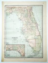
1889 Color Map of the State of Florida
by Cram, Geo. F.
- Used
- very good
- first
- Condition
- Used - Very Good
- Edition
- First Edition Thus
- Quantity Available
- 1
- Seller
-
Ladysmith, British Columbia, Canada
- Item Price
-
$195.00$16.99 shipping to USA
Show Details
Description:
Rochester, NY: W.H. Stewart, 1889. Book. Illus. by Cram, Geo. F.. Very Good. Map. First Edition Thus. Folio - over 12" - 15" tall. Outer dimensions: 10.75" x 14.5". Counties individually colored. Clean and unmarked with light wear. An attractive vintage copy. Bonus: includes separate extensive list of Florida counties and towns/cities, complete with their populations in 1889..
Item Price
$195.00
$16.99
shipping to USA
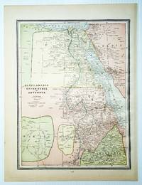
1889 Color Map of Egypt, Arabia, Upper Nubia and Abyssinia
by Cramm, Geo. F.
- Used
- very good
- first
- Condition
- Used - Very Good
- Edition
- First Edition Thus
- Quantity Available
- 1
- Seller
-
Ladysmith, British Columbia, Canada
- Item Price
-
$195.00$16.99 shipping to USA
Show Details
Description:
USA: W.H. Stewart, 1889. Book. Very Good. Map. First Edition Thus. Folio - over 12" - 15" tall. Outside dimensions 14.5" x 10.75". Unmarked with light wear and soiling. An attractive vintage copy..
Item Price
$195.00
$16.99
shipping to USA

Didn’t find what you’re looking for?
Try adding this search to your want list. Millions of books are added to our site everyday and when we find one that matches your search, we’ll send you an email. Best of all, it’s free.
Add to Want List

Are you a frequent reader or book collector?
Join the Bibliophile's Club and save 10% on every purchase, every day — up to $20 savings per order!

Social Responsibility
Did you know that since 2004, Biblio has used its profits to build 16 public libraries in rural villages of South America?