Description:
Geneva,: League of Nations,, 1932.. 320 by 220mm. (12.5 by 8.75 inches).. Books,""Appeal by the Chinese Government. Report of the Commission of Enquiry... The Lytton Report Folio (320 x 200mm), 148 pages, 14 maps on 13 folded leaves inserted in pocket attached to back cover. Known as the Mukden Incident, the detonation of dynamite along part of the South Manchuria Railway by a member of the 29th Japanese Regiment in 1931 allowed Japan to accuse Chinese dissidents of the attack, and gave them an excuse to launch a full invasion of Manchuria. Japan quickly occupied key Manchurian cities, in response to which China appealed for help from the world's powers. The Council of the League of Nations, supported by the United States, sought to negotiate a peaceful solution to the conflict. In January 1932, the Council dispatched an inquiry commission to China under the leadership of British diplomat, Victor Bulwer-Lytton, 2nd Earl of Lytton. By the time the so-called Lytton Commission arrived in China in the…
Read More Search Results: Authors starting with O from Daniel Crouch Rare Books Ltd
You searched for:
- Bookseller inventory: Daniel Crouch Rare Books Ltd (authors starting with O)
- Bookseller: Daniel Crouch Rare Books Ltd
Results 1 - 18 of 18

More Photos
signed by the members of the commission on September 4th, 1932, at Peiping.
by League of Nations
- Used
- Condition
- Used
- Quantity Available
- 1
- Seller
-
London, United Kingdom
- Item Price
-
$1,891.20$18.91 shipping to USA
Show Details
Item Price
$1,891.20
$18.91
shipping to USA

China South East Coast. Hong Kong to the Brothers: Admiralty chart of the South East Coast of China From various Admiralty Surveys between 1845 and 1925.
by HYDROGRAPHIC OFFICE
- Used
- Condition
- Used
- Quantity Available
- 1
- Seller
-
London, United Kingdom
- Item Price
-
$1,134.72$18.91 shipping to USA
Show Details
Description:
London,: Published at the Admiralty,, New Edition 27th Dec., 1922. Small corrections to 1923.. 710 by 1330mm. (28 by 52.25 inches).. Engraved chart, including tidal information, compass roses, soundings, seabed notations, currents, sandbanks, shoals, lighthouses and beacons picked out in yellow and red, inland elevations and detailing, insets of Tai Sami and Goat Island. Detailed chart of the South East coast of China. The British Hydrographic Office was founded in 1795 by George III, who appointed Alexander Dalrymple as the first Hydrographer to the Admiralty. The first charts were produced in 1800. Unlike the U. S. Coast Survey the Hydrographic Office was given permission to sell charts to the public and they produced a great number of sea charts covering every corner of the globe. Most of the Admiralty charts produced by the Hydrographic Office delineated coastline as well as high and low water marks and record depth of water as established by soundings. In addition these charts included…
Read More Item Price
$1,134.72
$18.91
shipping to USA

China Sea. Gulf of Siam.: Admiralty chart of the Gulf of Thailand Chiefly from Surveys of John Richards, Master Commanding H.M.S. Saracen, 1859.
by HYDROGRAPHIC OFFICE
- Used
- Condition
- Used
- Quantity Available
- 1
- Seller
-
London, United Kingdom
- Item Price
-
$2,017.28$18.91 shipping to USA
Show Details
Description:
London,: Published at the Admiralty,, 1st. April, 1881, 1922. Large corrections to 23rd Dec. 1923. Small corrections to 1932.. 1070 by 710mm. (42.25 by 28 inches).. Engraved chart, including tidal information, compass roses, soundings, seabed notations, currents, sandbanks, shoals, lighthouses and beacons picked out in yellow and red, with inland elevations. Detailed chart of the Gulf of Thailand. The British Hydrographic Office was founded in 1795 by George III, who appointed Alexander Dalrymple as the first Hydrographer to the Admiralty. The first charts were produced in 1800. Unlike the U. S. Coast Survey the Hydrographic Office was given permission to sell charts to the public and they produced a great number of sea charts covering every corner of the globe. Most of the Admiralty charts produced by the Hydrographic Office delineated coastline as well as high and low water marks and record depth of water as established by soundings. In addition these charts included information on shoals, reefs,…
Read More Item Price
$2,017.28
$18.91
shipping to USA

Harbours & Anchorages in the Red Sea: Admiralty chart of the harbour's and Anchorages in the Red Sea
by HYDROGRAPHIC OFFICE
- Used
- Condition
- Used
- Quantity Available
- 1
- Seller
-
London, United Kingdom
- Item Price
-
$882.56$18.91 shipping to USA
Show Details
Description:
London,: Published at the Admiralty,, 11th June 1873. New editions to 1918. Small corrections to 1919. . 690 by 860mm. (27.25 by 33.75 inches).. Nine engraved charts on one map sheet, detailing anchorages at Safaja Island, Akik Seghir, Mersa Halaib, Mersa Sheikh Ibrahim, Sherm Dumeigh, Hodeida Road, Approaches to Ras El Askar, Farisan I., and Eid Road, including tidal information, compass roses, soundings, seabed notations, currents, sandbanks, shoals, lighthouses and beacons, inland elevations, detailing and buildings. Detailed chart of the harbours and anchorages in the Red Sea. When the Suez Canal opened in 1869, the Red Sea began to experience a significant increase in the traffic, especially from the British shipping plying their trade between England and the India. The chart must have greatly aided their passage with its detailed depiction of nine safe harbours and archorages. The British Hydrographic Office was founded in 1795 by George III, who appointed Alexander Dalrymple as the first…
Read More Item Price
$882.56
$18.91
shipping to USA

China Sea. North Coast of Formosa (Taiwan) Kiirun Ko (Keelung Harbour): Admiralty chart of northern Taiwan From the Japanese Government Plans of 1919.
by HYDROGRAPHIC OFFICE
- Used
- Condition
- Used
- Quantity Available
- 1
- Seller
-
London, United Kingdom
- Item Price
-
$1,197.76$18.91 shipping to USA
Show Details
Description:
London,: Published at the Admiralty,, New Edition 11th April, 1921. Small corrections to 1923.. 710 by 1040mm. (28 by 41 inches).. Engraved chart, including tidal information, compass roses, soundings, seabed notations, currents, sandbanks, shoals, lighthouses and beacons picked out in yellow and red, inland elevations, detailing, and buildings. Detailed chart of the Keelung Port on the north coast of Taiwan. Taiwan at the time of the chart's publication was under the control of the Japanese, who in 1895 had gained control of the island from the Chinese after the First Sino-Japanses War. Under the adminstration of the Japanese Keelung became one of the major trading ports in Taiwan. Although heavily bombed during the Second World War, the port today is one of the busiest container ports in the world. The British Hydrographic Office was founded in 1795 by George III, who appointed Alexander Dalrymple as the first Hydrographer to the Admiralty. The first charts were produced in 1800. Unlike the U. S.…
Read More Item Price
$1,197.76
$18.91
shipping to USA

A Humorous Diplomatic Atlas of Europe and Asia.: Serio Comic map of Europe
by OHARA, Kisahuro
- Used
- Condition
- Used
- Quantity Available
- 1
- Seller
-
London, United Kingdom
- Item Price
-
$7,564.80$18.91 shipping to USA
Show Details
Description:
1904.. 420 by 570mm (16.5 by 22.5 inches).. Colour lithograph map. A wonderful example of the rare 1904 Kisabur Ohara satirical 'Octopus Map' of Europe. Composed at the outbreak of the Russo-Japanese War (1904 1905), Ohara here follows the conventions established by J.J. van Brederode ( Humoristische-Oorlogskaart, 1870) and Fred Rose (Serio-Comic War Map, 1877). These two maps established the convention, of satirizing Russian expansionism as a menacing Kraken-like 'Black Octopus.' Whereas Brederode and Rose confine their images to Russia, Ohara has here expanded the idea to encompass all of Eurasia. Russia's eight grasping tentacles extend across Europe and Asia; on many countries they already have a firm grip. Finland, Poland, Crimea, and the Balkan nations are represented as skulls, while tentacles grasp Turkey around the foot and waist, Persia about the neck, and Tibet by the arm. The Trans-Siberian Railway and the South Manchuria Railway, represented by the rightmost tentacle, had by this…
Read More Item Price
$7,564.80
$18.91
shipping to USA
![[Portolan Atlas of the Mediterranean].](https://d3525k1ryd2155.cloudfront.net/h/235/922/1163922235.0.m.jpg)
More Photos
[Portolan Atlas of the Mediterranean].: A magnificent portolan atlas signed by a member of the leading family of chart-makers of the Mediterranean Franciscus Oliva Me Fecit in Civitae Marsilia Anno Domini 1658.
by OLIVA, Franciscus [II]
- Used
- Hardcover
- Signed
- Condition
- Used
- Binding
- Hardcover
- Quantity Available
- 1
- Seller
-
London, United Kingdom
- Item Price
-
$567,360.00$18.91 shipping to USA
Show Details
Description:
Marseille,, 1658.. Portolan atlas (510 by 340mm) comprising of 10 manuscript charts on vellum (six double page and four single page) pasted on thick card, coloured in ink wash and gouache throughout and heightened in gold, lavish decorative motifs on compass roses, scale bars, armorial shields and name cartouches, each chart within a simple yellow border, the outlines in sepia, main islands in gold, the rest in red, blue, green, coastlines red, blue, green and pink, rivers in blue, main names in red and the rest in brown ink, rhumblines in sepia, red and green; some typical signs of wear, particularly on the borders, resulting in some tears and losses which in some cases have been reinstated; owner label pasted to upper marbled paper pastedown, contemporary vellum binding. The portolan chart originated in thirteenth century Italy, as an aid to the pilots navigating their way across the often treacherous Mediterranean Sea. They are characterized by rhumb lines, lines that radiate from the centre in…
Read More Item Price
$567,360.00
$18.91
shipping to USA
![[Portolan Chart of the Mediterranean].](https://d3525k1ryd2155.cloudfront.net/h/189/506/1391506189.0.m.jpg)
[Portolan Chart of the Mediterranean].: A fine portolan signed and dated by one of the most prolific chart makers of the Mediterranean
by OLIVA, Joan
- Used
- Hardcover
- Signed
- Condition
- Used
- Binding
- Hardcover
- Quantity Available
- 1
- Seller
-
London, United Kingdom
- Item Price
-
$252,160.00$18.91 shipping to USA
Show Details
Description:
[Messina,, 1610].. 460 by 860mm. (18 by 33.75 inches).. Pen, ink, and wash colour on vellum, highlighted in silver and gold, extending west to east from Cape Finisterre to the Holy Land, and north to south from Ukraine to the north coast of Africa, islands in red, blue and green, rivers in blue, numerous coastal place-names in red and sepia in semi-italic lettering, 14 large and small compass roses, many with fleur-de-lys north points, heightened in gold, crucifix to neck, the whole chart divided by red, green, and sepia, rhumb lines extending from the compass roses, gilt borders, scale upper and lower centre, la few small nicks to right margin of chart, one or two at shoulders. Finely drawn chart of the Mediterranean attributed to Joan Oliva. The chart has been attributed to Joan Oliva (fl.1570-1614), a leading member of the Oliva family, a cartographic dynasty who dominated portolan production in Europe during the sixteenth and early seventeenth centuries. Charts signed by no fewer than 16…
Read More Item Price
$252,160.00
$18.91
shipping to USA

More Photos
Nouvelle Carte de la Mer Mediterranee: Rare chart of the Mediterranean Juscques au Cap S. Vincent et Cap Cantin.
by OLIVIER, F[rançois]
- Used
- Condition
- Used
- Quantity Available
- 1
- Seller
-
London, United Kingdom
- Item Price
-
$7,564.80$18.91 shipping to USA
Show Details
Description:
Toulon,, 1746.. 580 by 810mm. (22.75 by 32 inches).. Engraved chart on two sheets, a few marks, backed on japan paper with some minor loss to old folds. To the upper right of the chart is a elaborate title cartouche with Neptune riding two white horses together with other personifications of the sea. Above is the coat-of-arms of Jean-Frédéric Phélypeaux, Count of Maurepas, head of the French navy and, to whom the chart is dedicated. Below the title are French, Dutch, Spanish, and Italian scale bars. The scale bars are depicted in the second (Eastern half) sheet within an elaborate cartouche. Little is know of François Olivier (fl.1746-1782), however, he must have been a fine seaman as he present chart gives him the title of Vice-Admiral of the Toulon region ("Vice-Amiral au Departement de Toulon"). By the middle of the eighteenth century Toulon had become one of France's most important naval bases, from where she opperated her large Mediterranean fleet. Rare. We are only able to trace three…
Read More Item Price
$7,564.80
$18.91
shipping to USA
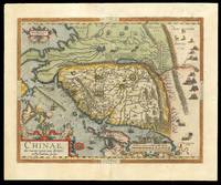
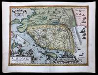
Chinae olim Sinarum regionis, nova descriptio.: The earliest printed map to focus on China Auctore Ludouico Georgio.
by ORTELIUS, Abraham
- Used
- Condition
- Used
- Quantity Available
- 1
- Seller
-
London, United Kingdom
- Item Price
-
$5,673.60$18.91 shipping to USA
Show Details
Description:
[Antwerp,: Plantin Press],, 1584.. 450 by 540mm. (17.75 by 21.25 inches).. Engraved map with hand colour, loss to top right margin skilfully reinstated. The earliest printed map to focus on China, and the first to illustrate the Great Wall. It was the first western map of China drawn directly from the findings of the Portuguese mapmaker Luis Jorge de Barbuda, or Ludovicus Georgius. Barbuda was a Jesuit, and he made a manuscript map of China from information on the area gathered by the Jesuit mission. Arias Montanus passed this map on to Ortelius. He issued this first separately published map of China in 1584, which remained the standard map of China for over fifty years. The map is oriented to the west. Japan is shown on a curved projection, borrowing from Portuguese sources. Wind wagons are shown in the north, a Chinese invention that also became popular in the Low Countries. The text on the reverse of the map is in Latin and gives an insight into the climate, national features, inhabitants and…
Read More Item Price
$5,673.60
$18.91
shipping to USA
Chinae olim Sinarum regionis, nova descriptio.: The earliest printed map to focus on China Auctore Ludouico Georgio.
by ORTELIUS, Abraham
- Used
- Condition
- Used
- Quantity Available
- 1
- Seller
-
London, United Kingdom
- Item Price
-
$7,564.80$18.91 shipping to USA
Show Details
Description:
[Antwerp,: Plantin Press],, 1584 [1595].. 440 by 550mm. (17.25 by 21.75 inches).. Hand-coloured engraved map with fine original colour. The earliest printed map to focus on China, and the first to illustrate the Great Wall. It was the first western map of China drawn directly from the findings of the Portuguese mapmaker Luis Jorge de Barbuda, or Ludovicus Georgius. Barbuda was a Jesuit, and he made a manuscript map of China from information on the area gathered by the Jesuit mission. Arias Montanus passed this map on to Ortelius. He issued this first separately published map of China in 1584, which remained the standard map of China for over fifty years. The map is oriented to the west. Japan is shown on a curved projection, borrowing from Portuguese sources. Wind wagons are shown in the north, a Chinese invention that also became popular in the Low Countries. The text on the reverse of the map is in Latin and gives an insight into the climate, national features, inhabitants and economy of China at…
Read More Item Price
$7,564.80
$18.91
shipping to USA
![[Autograph letter to his nephew].](https://d3525k1ryd2155.cloudfront.net/h/457/506/1391506457.0.m.jpg)
More Photos
[Autograph letter to his nephew].: Ortelius writes to his "most brilliant and dearest nephew"
by ORTELIUS, Abra[ham]
- Used
- Condition
- Used
- Quantity Available
- 1
- Seller
-
London, United Kingdom
- Item Price
-
$63,040.00$18.91 shipping to USA
Show Details
Description:
Antwerp,, 4 January 1595.. 313 by 213mm. (12.25 by 8.5 inches).. Folio leaf (313 x 213mm), one page, manuscript letter in ink, integral address panel on verso. Mounted onto a guard to left margin, small loss to left margin likely from seal tear, two areas of old restoration to verso at right margin and in address panel. A hand-written letter from Abraham Ortelius to his "most brilliant and dearest nephew" Jacob Cole in Latin, concerning his magnum opus. Ortelius begins his missive with commiserations for the death of his nephew's wife and encourages him 'to bear this grief with a calm mind'. After issuing some general praise for his sister, Ortelius goes on to discuss Jacob's opinion on two of the age's most important cartographical works: Camden's 'Brittania' and his own 'Theatrum Orbis Terrarum', which he refers to simply as "my Theatre". Jacob appears to have sent his uncle a copy of the former, as Ortelius exhorts him to "write about the example of Camden's Britannia you sent as well. I have…
Read More Item Price
$63,040.00
$18.91
shipping to USA

Makes all Sorts of Widows Weeds, Robers, Riding-habits, Sultains, Banians, Common Gowns, Vests and Tunicks for boys, Coaks and Hoods, &c. the Newest Fashion
by OTTO, Matthias
- Used
- Hardcover
- Condition
- Used
- Binding
- Hardcover
- Quantity Available
- 1
- Seller
-
London, United Kingdom
- Item Price
-
$2,521.60$18.91 shipping to USA
Show Details
Description:
London: At the Royal Widow & Sun over against Bullin Court in the Strand, near the new Exchange,, [c1850].. 155 by 95mm (6 by 3.75 inches).. Prints,""Matthias Otto Junr... W is for Widow Outfitter Engraved trade card. The trade card of Matthias Otto Senior, much the same in style and language to the present card, is believed to have been in circulation from around 1735. The fact that both list the same address at Bullin Court on the Strand indicates that the son took over the family business after the death of his eponymous father. Matthias Otto Junior's trade card appears to be from the mid-eighteenth century, and offers a glimpse into the behaviour expected of widowed women at that time. The first article mentioned on Otto's card are """"Widows Weeds"""" which, in 'A Dictionary of the English Language' (1755), Dr Johnson describes as """"a garment of clothing, habit, or dress. Now scarce in use, except in 'widows weeds', the mourning dress of a widow"""". As well as """"Common Gowns, Vests and…
Read More Item Price
$2,521.60
$18.91
shipping to USA

An Actual Survey of the County of Sussex: Sussex - Rare separately issued map of Sussex Divided into Rapes Hundreds and Deanries...
by OVERTON, Phillip
- Used
- Condition
- Used
- Quantity Available
- 1
- Seller
-
London, United Kingdom
- Item Price
-
$2,521.60$18.91 shipping to USA
Show Details
Description:
London,: Printed and sold by Philip Overton near St Dunstan's Church Fleetstreet, and Thomas Bowles next ye Chapter house in St. Paul's Church yard,, [c1726].. 590 by 990mm (23.25 by 39 inches).. Engraved map with outline hand colouring, on two sheets joined, loss to upper left corner skilfully supplied in facsimile. Rare separately issued map of Sussex. This large two sheet map is a reduction of Budgen's large-scale map of the county first published in 1724 - the first large-scale map of the county. A detailed key to the upper right provides information on market towns, disused habitations, Gentleman's Seats, manor of farm houses, castles, ruins abbeys, priorys etc., furnaces, forges, watermills, smiths forges, camps, heaths, mineral waters, stone quarries, woodland, commons, rocks, sands, boundaries of county, rapes, deanries, hundreds, navigable rivers, and 'parts abounding most with Oak Timber. To the sea around the Selsey peninsula are depicted shoals, rocks, and numerous soundings. Above the…
Read More Item Price
$2,521.60
$18.91
shipping to USA

More Photos
or Views of the Bodleian Library, the Theatre, Publick Schools, Colleges, Halls, and other Publick Buildings of the University of Oxford, with an account of their Foundations and Endowments and a succinct description of the Buildings
by OVERTON, Henry; and HOOLE, John; after LOGGAN, David
- Used
- Condition
- Used
- Quantity Available
- 1
- Seller
-
London, United Kingdom
- Item Price
-
$6,304.00$18.91 shipping to USA
Show Details
Description:
London,: Printed and Sold by H. Overton and J. Hool at the White Horse without Newgate, London, where may be had any of the Colleges of Oxford or Cambridge, each of them printed on a Sheet of Royal Paper & neatly graved by D. Loggan, [c1710].. 590 by 975mm. (23.25 by 38.5 inches).. Prints,""Oxonia Illustrata, An extravagant broadsheet advertisement for Overton's edition of Loggan Engraving, printed on two joined sheets. A very large, rare, and separately published advertisement for Overton's issues of David Loggan's celebrated 'Oxonia Illustrata', the plates for which were acquired by Overton, or his father John, at some point during the decade following Loggan's death in 1692. A partner, showing Loggan's Cambridge views, was likely printed at the same time, though the exact date of publication for both is unknown, and it is unclear whether the pair were intended to advertise Overton's reprints of 'Oxonia Illustrata' and 'Cantabrigia Illustrata' in 1705 and 1715 respectively, or simply that he was…
Read More Item Price
$6,304.00
$18.91
shipping to USA

A New Mapp of the Whole World.: The Chinesian Ocean"
by OVERTON, Henry
- Used
- Condition
- Used
- Quantity Available
- 1
- Seller
-
London, United Kingdom
- Item Price
-
$146,252.80$18.91 shipping to USA
Show Details
Description:
London,: Henry Overton,, 1738.. 1498 by 1600mm. (59 by 63 inches).. Engraved map on four sheets, with fine original hand-colour. Henry Overton (1676-1751) was a publisher and mapseller who followed in the footsteps of his father, John Overton, when he took over his shop and stock in 1707. Over the course of his career he published a large number of maps, as well as numerous views, portraits and sporting prints. Overton's maps were largely focused on the British Isles, and he also produced revised and updated editions of John Speed's country atlas. One of his most visually striking and rarest works, however, is 'A New Mapp of the World by Henry Overton'. The map describes the world in two hemispheres, with two smaller pairs of hemispheres above and below, showing the heavens and the polar regions respectively. This design reflects the world maps published by Gerard Valk at the end of the seventeenth century, but Overton's geographical configuration is notably less sophisticated, corresponding more…
Read More Item Price
$146,252.80
$18.91
shipping to USA

A Map of the Coast of Spain, from the Streights of Gibralter to the Gulf of Cartagena.: The siege of Gibraltar S. Parker sculpt. Sold by H: Overton and I. Hoole at the White | Horse without Newgate London. A New PLAN of the Garrison of GIBRALTER, with its fortifications &c. 1726.
by OVERTON, Henry (I) & HOOLE, John
- Used
- Condition
- Used
- Quantity Available
- 1
- Seller
-
London, United Kingdom
- Item Price
-
$2,269.44$18.91 shipping to USA
Show Details
Description:
London,: Henry Overton (I) and John Hoole,, 1727.. Two engraved maps printed on a single sheet. Very scarce composite sheet depicting Gibraltar from the siege of 1727; the sheet bears a general map of the south-eastern coast of Spain from Seville and Cadiz to Cartagena, with an inset of the Straits of Gibraltar (194 x 469 mm); printed below, from a second plate, is a plan of Gibraltar's fortifications (195 x 471 mm). The partnership of Overton and Hoole can be dated, from newspaper advertisements located thus far, from 6th August, 1724 to 8th - 10th May, 1733. A joint catalogue, dated 1734, probably denotes the partners' attempts to liquidate their joint assets, although the partnership finally ended with Hoole's death on 25th December, 1734. The map of the coast of Spain is here in its first recorded state, with the blank inset frame at bottom right. In the second state, a map of Minorca was inserted there. COPAC records only one example of the second state, in the British Library.
Item Price
$2,269.44
$18.91
shipping to USA

Chart of the East Coast of Madagascar: such parts of the coast of Madagascar as you may conceive not to have been accurately ascertained" including the Mauritius, Seychelle Islands &c. Between the Latitudes of 2°30 & 26°30'S. And the Longitudes of 47° & 67°E. From the operations of H.M.Shi
by OWEN, William Fitzwilliam
- Used
- first
- Condition
- Used
- Quantity Available
- 1
- Seller
-
London, United Kingdom
- Item Price
-
$3,152.00$18.91 shipping to USA
Show Details
Description:
London,: Hydrographical Office,, 1828.. 820 by 645mm. (32.25 by 25.5 inches).. Engraved chart on two sheets joined. This first edition of Captain Owen's chart of the east coast of Madagascar presents the results of his five-year expedition to Africa. In 1821, William Fitzwilliam Owen was commissioned to undertake this voyage as captain of the Royal Navy ships Leven and Barracouta, and to survey the east coast from the Cape of Good Hope to Cape Guardafui. Included in this was the task of "examining and observing the true position of the numerous islands and shoals between Madagascar and the main and north and north-eastward of Madagascar, and also such parts of the coast of Madagascar as you may conceive not to have been accurately ascertained". Over the following five years, Owen and his crews mapped 30,000 miles of coastline, covering vast stretches of the African mainland as well as the surrounding islands. During the expedition, the captain kept a diary, which he later published as a two-volume…
Read More Item Price
$3,152.00
$18.91
shipping to USA

Didn’t find what you’re looking for?
Try adding this search to your want list. Millions of books are added to our site everyday and when we find one that matches your search, we’ll send you an email. Best of all, it’s free.
Add to Want List

Are you a frequent reader or book collector?
Join the Bibliophile's Club and save 10% on every purchase, every day — up to $20 savings per order!

Social Responsibility
Did you know that since 2004, Biblio has used its profits to build 16 public libraries in rural villages of South America?