Description:
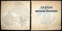
Washington D.C.,: United States Hydrographic Office,, 1946.. Arctic Ice Atlas Large folio (625 by 640mm), index chart as front pastedown, title, preface signed by George S. Bryan, Rear Admiral, 86 full and half-page chromolithographed maps and charts, divisional titles, tables, bibliography; original ring-bound pictorial blind-stamped black cloth binding, gilt title. Arctic exploration reached new heights in the early twentieth century with the first successful expedition to the North Pole. Throughout the following decades, countries started to claim territorial rights in the Artic for economic, industrial and above all military reasons. In the Second World War, the Arctic region became a key supply route for then-allies the United States and the USSR. Naturally, its strategic importance only increased during the Cold War. In 1946, the US Navy published an atlas of the northern hemisphere documenting the extent of and changes to the ice formation across the Arctic. Coloured monthly maps for each…
Read More Search Results: Authors starting with S from Daniel Crouch Rare Books Ltd
You searched for:
- Bookseller inventory: Daniel Crouch Rare Books Ltd (authors starting with S)
- Bookseller: Daniel Crouch Rare Books Ltd
Results 1 - 20 of 109
More Photos
Ice Atlas of the Northern Hemisphere.
by U.S. NAVY
- Used
- Hardcover
- Signed
- Condition
- Used
- Binding
- Hardcover
- Quantity Available
- 1
- Seller
-
London, United Kingdom
- Item Price
-
$2,512.20$18.84 shipping to USA
Show Details
Item Price
$2,512.20
$18.84
shipping to USA
![[Untitled World Map].](https://d3525k1ryd2155.cloudfront.net/h/125/506/1391506125.0.m.jpg)
[Untitled World Map].: Salamanca and Lafreri's double-cordiform world
by SALAMANCA, Antonio
- Used
- Condition
- Used
- Quantity Available
- 1
- Seller
-
London, United Kingdom
- Item Price
-
$87,927.00$18.84 shipping to USA
Show Details
Description:
Rome,: Antonio Lafreri, , 1564.. 340 by 520mm (13.5 by 20.5 inches).. Double-page engraved map on a cordiform projection. First published by Salamanca in about 1550, and based on the double-cordiform world map by Gerard Mercator of 1538. This issue, with Lafreri's imprint, dates from after Lafreri had taken control of their joint publishing business in 1563. Like its predecessors, Salamanca's striking map "bisects the world on the Equator, with the southern hemisphere featuring a mysterious continent centred on the South Pole, centuries before the discovery of Antarctica. Following Mercator, Salamanca showed the Americas as being two continents, labelled north and south, and being entirely separate from Asia. A large ice-mass is shown covering the world's Arctic regions. Salamanca's rendering is distinguished from Mercator's by his use of stipple engraving for the seas. Beyond being a most elegant artistic concept, cordiform maps were considered to be imbued with great emblematic significance by…
Read More Item Price
$87,927.00
$18.84
shipping to USA

More Photos
Jn. Salis Suc.r de M.r Desplan
by SALIS, J.n
- Used
- Condition
- Used
- Quantity Available
- 1
- Seller
-
London, United Kingdom
- Item Price
-
$1,067.68$18.84 shipping to USA
Show Details
Description:
Limoges,: Rue Du Consulat No. 3, Près la place des bancs,, 1840.. 270 by 210mm. (10.75 by 8.25 inches).. Prints,""Grand Dépôt de Sangsues Sortant des Réservoirs L is for Leech Farmer Lithographed order-form, with manuscript address and notes in ink, ink-stamp to verso. Based in Limoges, the Grand Dépôt de Sangsues supplied France with a ready supply of leeches. During the nineteenth century, these creatures were still used for medicinal purposes, placed on ailing patients in a form of blood-letting known as leeching. Thought to stimulate blood flow, treat. Infection or prevent disease, the practice consisted of placing live leeches on a patient's bare skin; some could lose up to 80% of their blood in a single session. The leeches most commonly used were the European Medicinal Leech, or the Hirudo medicinalis, with its segmented body, three jaws set with 100 small but sharp teeth, and anaesthetizing saliva. Having been practiced for thousands of years, leeching became particularly popular at…
Read More Item Price
$1,067.68
$18.84
shipping to USA
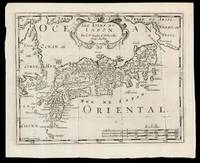
Les Isles dv Iapon: Second state of Halma's pirated edition of Sanson's map of Japan
by SANSON D'ABBEVILLE, Nicolas (I) and HALMA, Francois
- Used
- Condition
- Used
- Quantity Available
- 1
- Seller
-
London, United Kingdom
- Item Price
-
$188.42$18.84 shipping to USA
Show Details
Description:
[Amsterdam,: Chez Arnout van Ravenstein,, 1699].. 222 by 272mm. (8.75 by 10.75 inches).. Engraved map. Second state of the plate, first published in Halma's pirated edition of Sanson's 'L'Asie en plvsiers cartes nouvelles, et exactes;
', as part of 'L'Europe; L'Asie; L'Amerique
en Pluiers Cartes', 1683. A direct copy of Sanson's map of 1652, the only differences being the lack of a privilege and a date in the cartouche, the addition of the signature of the engraver, Antoine de Winter in the lower left corner. This issue is distinguished by the addition of mountains added in 'Isle de Corey' and 'Terre de Iesso'; and the 'Mer de Japan' above 'Oriental'. Francois Halma (1653-1722) set up his printing business in Utrecht in 1674, where he issued a number of pirated maps and atlases. In this instance, since Sanson was dead, Halma may have felt that there no harm and much profit to be gained from re-printing his work. The engraver, Antoine de Winter (c1652-1700) achieved some notoriety for plagiarizing…
Read More Item Price
$188.42
$18.84
shipping to USA
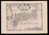
De Eilanden van Japan: Halma's Dutch edition of Sanson's map of Japan
by SANSON D'ABBEVILLE, Nicolas (I) and HALMA, Francois
- Used
- Condition
- Used
- Quantity Available
- 1
- Seller
-
London, United Kingdom
- Item Price
-
$50.24$18.84 shipping to USA
Show Details
Description:
[Amsterdam,: Francois Halma,, 1705].. 221 by 311mm. (8.75 by 12.25 inches).. Engraved map. Third state of the plate, first published in Halma's pirated edition of Sanson's 'L'Asie en plvsiers cartes nouvelles, et exactes;
', as part of 'L'Europe; L'Asie; L'Amerique
en Pluiers Cartes', 1683. A direct copy of Sanson's map of 1652, the only differences being the lack of a privilege and a date in the cartouche, the addition of the signature of the engraver, Antoine de Winter in the lower left corner. This issue was published in Halma's Dutch edition, 'Algemeene Wereldbeschryving
' in 1705 and is distinguished by the change of the title from French into Dutch. Francois Halma (1653-1722) set up his printing business in Utrecht in 1674, where he issued a number of pirated maps and atlases. In this instance, since Sanson was dead, Halma may have felt that there no harm and much profit to be gained from re-printing his work. The engraver, Antoine de Winter (c1652-1700) achieved some notoriety for…
Read More Item Price
$50.24
$18.84
shipping to USA

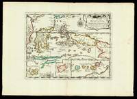
entre lesquelles sont Sumatra, Iava, Borneo, &c.
by SANSON, Nicolas
- Used
- Condition
- Used
- Quantity Available
- 1
- Seller
-
London, United Kingdom
- Item Price
-
$690.86$18.84 shipping to USA
Show Details
Description:
[Utrecht,: Johannes Ribbius and Simon de Vries, , 1682-1683].. 215 by 290mm. (8.5 by 11.5 inches).. Maps,""Les Isles de la Sonde, Singapore as part of the mainland Engraved map. Detailed map of western Southeast Asia, including the Malay Peninsula, Sumatra, Java and Borneo. Showing """"Sinca=pura"""" as part of the mainland. First published in 'L'Asie en Plusieurs Cartes...' (1652) engraved by A. Peyrounin. Johannes Ribbius and Simon de Vries published a German edition in 1682 and 1683, with new maps engraved by Antoine d'Winter, retaining the French captions on the maps. Nicolas Sanson (1600-1667) began to make maps to supplement his study of history, and a map of Ancient Gaul, made early in his career brought him to the attention of Cardinal Richelieu. This foothold in the French court allowed him to rise to the position of geographe du roi, teaching both Louis XIII and Louis XIV. Louis XIII even made him a counsellor of state. Sanson produced an atlas, 'Cartes Generales de Toutes les Parties…
Read More Item Price
$690.86
$18.84
shipping to USA
Par le S.r Sanson dAbbeville, Geog.e du Roy Avec privilege pour 20 ans. 1652.
by SANSON, Nicolas
- Used
- Condition
- Used
- Quantity Available
- 1
- Seller
-
London, United Kingdom
- Item Price
-
$376.83$18.84 shipping to USA
Show Details
Description:
[Paris,: chez l'autheur,, 1652].. 265 by 370mm. (10.5 by 14.5 inches).. Maps,""Les Isles Molucques; Celebes, Gilolo, &c. Sanson's Moluccas Engraved chart with contemporary hand-colour in outline. Detailed map of the island east of Borneo in Southeast Asia, with an inset of Banda and the Moluccas. Published in Sanson's 'L'Asie en Plusieurs Cartes...' (1652). Nicolas Sanson (1600-1667) began to make maps to supplement his study of history, and a map of Ancient Gaul, made early in his career brought him to the attention of Cardinal Richelieu. This foothold in the French court allowed him to rise to the position of geographe du roi, teaching both Louis XIII and Louis XIV. Louis XIII even made him a counsellor of state. Sanson produced an atlas, 'Cartes Generales de Toutes les Parties du Monde', which contained important maps of the post roads and waterways of France. He also produced two major maps of North America: 'Amerique Septentrionale' (1650) was the first map to show the Great Lakes in a…
Read More Item Price
$376.83
$18.84
shipping to USA

More Photos
The New York 1939 World's Fair Map
by SARG, Anthony Frederick, "Tony"
- Used
- Condition
- Used
- Quantity Available
- 1
- Seller
-
London, United Kingdom
- Item Price
-
$1,507.32$18.84 shipping to USA
Show Details
Description:
Boston, Mass, : Rugg Mfg. Co., exclusively for IN-A-CANE Display Co., , 1939.. 340 by 500mm. (13.5 by 19.75 inches); cane 890mm long. Promising: "Villages Restaurants Free Exhibits The World of Tomorrow Wonderful Fireworks every Night Bathing Beauties Jungles" Colour printed pictorial map, spring-rolled inside a wooden walking stick. The New York 1939 World's Fair marked the 150th Anniversary of the inauguration of President George Washington. Staged at Flushing Meadows and Corona Park, The World of Tomorrow, offered a "glimpse of the future". Tony Sarg (1880-1942), is best known for introducing the enormous inflatable cartoon caricatures to the Macy's Thanksgiving Day Parade, that are now its trademark. Sarg was born "in Germany, his father was an artist, his grandfather a wood-carver, and his grandmother was a painter who gave the young Sarg a collection of mechanical toys that may have inspired the imagination of the burgeoning designer. But it wasn't until he saw a performance by…
Read More Item Price
$1,507.32
$18.84
shipping to USA

una cum suis undiq confinibus, oppidis, pagis, villis, et fluminibus in eisdem vera descriptio. An Dm 1574
by SAXTON, Christopher
- Used
- first
- Condition
- Used
- Quantity Available
- 1
- Seller
-
London, United Kingdom
- Item Price
-
$6,280.50$18.84 shipping to USA
Show Details
Description:
London,: Christopher Saxton,, 1579.. 420 by 550mm. (16.5 by 21.75 inches).. Maps,""[Oxfordshire, Buckinghamshire and Berkshire] Oxonii buckinghamiae et berceriae Comitatum The first printed map of Oxfordshire, Buckinghamshire and Berkshire Double-page engraved map, fine original full-wash colour, some minor offsetting, contemporary annotation on verso in brown ink, some light marginal soiling. Oxfordshire, Buckinghamshire and Berkshire, each boldly distinguished in its own colour, are presented here on the first ever map to show these respective counties. Commissioned by the Queen's Privy Council in 1575, Christopher Saxton surveyed the landscape, settlements and estates of England and Wales. The results were represented on 35 maps compiled into the first national atlas, his 'Atlas of England and Wales'. The densely packed features of this map are all labelled with their English names in sixteenth century form, while the surrounding counties are recorded in Latin. Major cities, such as Oxford,…
Read More Item Price
$6,280.50
$18.84
shipping to USA

The Travellers Guide being the best Mapp of the Kingdom of England and Principality of Wales: A nation defined An Elizabethan wall map by "the father of English cartography" Wherein are Delineated 3000 Towns & Villages more than in any Mapp yet Extent besides ye Notations of Bridges & Rivers &c. To which is added ye Direct and cross Roads accord
by SAXTON, Christopher
- Used
- first
- Condition
- Used
- Quantity Available
- 1
- Seller
-
London, United Kingdom
- Item Price
-
$94,207.50$18.84 shipping to USA
Show Details
Description:
London,, [1583, but c1716].. 1350 by 1710mm (53.25 by 67.25 inches).. Engraved wall map, printed on 20 sheets, joined, with fine original full body colour. Christopher Saxton's wall map is a result of the first survey of the whole of England and Wales, and is the first map of those countries to give all the place names in English. Saxton has been dubbed "the father of English cartography" (Skelton). The idea of making a survey of the kingdom and its parts in a consistent format developed in the mid sixteenth century. Although the first English map of Britain, by Matthew Paris, had appeared in about 1250, it was not until the mid fifteenth century that the principles of mapping were fully understood. These techniques emerged, in part, as a result of the practical needs of military engineers: military surveyors were well able to draft plans and topographical maps to scale by the 1540s. Estate surveys also became increasingly popular, as the advent of enclosures necessitated the definition of land…
Read More Item Price
$94,207.50
$18.84
shipping to USA
![[Essex] Essexiae comitat](https://d3525k1ryd2155.cloudfront.net/h/111/507/1391507111.0.m.jpg)
[Essex] Essexiae comitat: The first printed map of Essex nova vera ac absoluta descriptio An. Dnu. 1576
by SAXTON, Christopher
- Used
- Condition
- Used
- Quantity Available
- 1
- Seller
-
London, United Kingdom
- Item Price
-
$3,140.25$18.84 shipping to USA
Show Details
Description:
London,: Christopher Saxton, , 1579. . 420 by 550mm. (16.5 by 21.75 inches).. Double-page engraved map, fine original full-wash colour, contemporary annotation on verso in brown ink. In 1575, Christopher Saxton was authorised by the Queen's Privy Council to survey and map the counties of England and Wales, a task which he had completed by 1579, when the resulting maps were compiled and published in his seminal Atlas of England and Wales. This map of Essex is one of the 35 maps included in the atlas, and the first county map of Essex ever to be produced. It records the county's landscape and settlements, represented by small illustrations of Churches, enclosed parklands, rivers, bridges, and the occasional hill. Details of the surrounding counties, labelled with their Latin names, are also included, most prominently London, represented by a mass of buildings, intricately illustrated. Saxton has also expressed certain features of Essex which would be of interest to the crown, such as the Blockhouse…
Read More Item Price
$3,140.25
$18.84
shipping to USA

Plan of Table Bay with the Road of the Cape of Good Hope, from the Dutch Survey Published by Joannes van Keulen: A rare sea chart of Cape Town
by SAYER, Robert and BENNETT, John
- Used
- first
- Condition
- Used
- Quantity Available
- 1
- Seller
-
London, United Kingdom
- Item Price
-
$4,019.52$18.84 shipping to USA
Show Details
Description:
London,: Robert Sayer and John Bennett,, 1778.. 541 by 480mm. (21.25 by 19 inches).. Engraved map. The first edition of a scarce English sea chart and plan of Cape Town and environs. Sayer and Bennett based their chart on Johannes van Keulen;s 1753 work, 'De Nieuwe Groote Lichtende Zee-Fakkel'. The map provides a British insight into the development of Cape Town, a time when the Dutch colony had expanded beyond the Liesbeeck River and the Dutch East India Company (VOC) was still keen to keep maps of the colony secret. The Plan of Table Bay is both a practical sea chart of Table Bay, which shows the route for maritime navigation, and also a plan of the terrestrial layout of the small town below Table Mountain, including its coastal fortifications, the "Company's Garden" and the infamous public gallows at the foot of the mountain. The "New Battery" on the western shore of the bay is the Chavonnes Battery, erected in the period 1717 to 1726; the "Cape Windmill" in the south-east is the Oude Molen…
Read More Item Price
$4,019.52
$18.84
shipping to USA

Secunda etas mundi.: Outlandish creatures and beings from the furthermost parts of the earth
by SCHEDEL, D. Hartman
- Used
- Condition
- Used
- Quantity Available
- 1
- Seller
-
London, United Kingdom
- Item Price
-
$28,890.30$18.84 shipping to USA
Show Details
Description:
Nuremberg,: Anton Koberger,, June 1493.. 427 by 567mm. (16.75 by 22.25 inches).. Double-page woodcut map with fine contemporary hand-colour in part. 'The world map is a robust woodcut taken from Ptolemy
What gives the map its present-day interest and attraction are the panels representing the outlandish creatures and beings that were thought to inhabit the furthermost parts of the earth. There are seven such scenes to the left of the map and a further fourteen on its reverse' (Shirley) From the famous 'Nuremberg Chronicle', a history of the world, published the year that Columbus returned to Europe after discovering America. The text is a year-by-year account of notable events in world history from the Creation down to the year of publication. It is a mixture of fact and fantasy, recording events like the invention of printing, but also repeating stories from Herodotus. Even the world map is decorated with strange beings from the far reaches, including a cyclops and a four-eyed man. 645 woodcuts…
Read More Item Price
$28,890.30
$18.84
shipping to USA

Secunda etas mundi.: Outlandish creatures and beings that were thought to inhabit the furthermost parts of the earth".
by SCHEDEL, D. Hartmann
- Used
- Condition
- Used
- Quantity Available
- 1
- Seller
-
London, United Kingdom
- Item Price
-
$30,146.40$18.84 shipping to USA
Show Details
Description:
Nuremberg,: Anton Koberger,, June 1493.. 405 by 590mm. (16 by 23.25 inches).. Double-page woodcut map. From the famous 'Chronicle of the World', known as the Nuremberg Chronicle, a history of the world, published the year that Columbus returned to Europe after discovering America. "The world map is a robust woodcut taken from Ptolemy What gives the map its present-day interest and attraction are the panels representing the outlandish creatures and beings that were thought to inhabit the furthermost parts of the earth. There are seven such scenes to the left of the map and a further fourteen on its reverse" (Shirley). The map is a copy of the Venetian woodcut added to Pomponius Mela's 'Cosmographia' eleven years earlier, and, like the Mela, shows the Portuguese discoveries off the west coast of Africa. The Schedel, however, also includes an unidentified island of this coast. The text of the Nuremberg Chronicle is a year-by-year account of notable events in world history from the creation of the…
Read More Item Price
$30,146.40
$18.84
shipping to USA

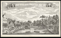
Gezigt Van De Koorn-Beurs, Staande op 't water by de Oude-brug 't Amsterdam: gebouwt in't Iaar 1768.: The Korenbeurs or Corn Exchange, Amsterdam Conspectus celebrttimus bursae frumenti ememndi Mercatores, recipiens: exstructa MDCCLXVIII. Amstelaedamum.
by SCHENK, Jan [after] LAAN, Adolphus van der
- Used
- Condition
- Used
- Quantity Available
- 1
- Seller
-
London, United Kingdom
- Item Price
-
$4,898.79$18.84 shipping to USA
Show Details
Description:
[Amsterdam,: Petrus Schenk,, c1775].. 545 by 935mm (21.5 by 36.75 inches).. Engraving with etching, on two sheets joined. The Korenbeurs or Corn Exchange was located on the New Side of the Damrak, south of the Oude Brug , on the site of the current Beurs van Berlage . The Korenbeurs was built in 1617 under the supervision of city architect Hendrick de Keyser , who was also responsible for the construction of the Koopmansbeurs in Rokin , completed in 1611. The simple building consisted of a courtyard surrounded on three sides by a wooden stoa. The middle stoa fronted the canal, and allowed ships to unload directly into the exchange. Samples of the grain, the majority of which had been imported from the Baltic, were housed in boxes, which hung on the walls of the other two stoas. In 1768, the Exchange was rebuilt in stone - the present view. The building was demolished in 1884, a year after the damming of the part of the Damrak between the Papenbrugsteeg and the Oude Brug. Jan Schenk (1698-1752) was…
Read More Item Price
$4,898.79
$18.84
shipping to USA

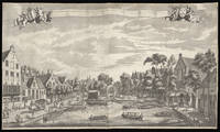
Gezigt Van de Koorn-Beurs, Staande Op't Water by De Oude-Brug't Amsterdam: Gebout In't Iaar. 1617.: The Korenbeurs or Corn Exchange, Amsterdam
by SCHENK, Jan; [after] LAAN, Adolf van der
- Used
- Condition
- Used
- Quantity Available
- 1
- Seller
-
London, United Kingdom
- Item Price
-
$3,768.30$18.84 shipping to USA
Show Details
Description:
Amsterdam,: Leonard Schenk,, [c1720].. 545 by 950mm. (21.5 by 37.5 inches).. Etching and engraving on two sheets joined. The Korenbeurs or Corn Exchange was located on the New Side of the Damrak, south of the Oude Brug , on the site of the current Beurs van Berlage . The Korenbeurs was built in 1617 under the supervision of city architect Hendrick de Keyser , who was also responsible for the construction of the Koopmansbeurs in Rokin , completed in 1611. The simple building consisted of a courtyard surrounded on three sides by a wooden stoa. The middle stoa fronted the canal, and allowed ships to unload directly into the exchange. Samples of the grain, the majority of which had been imported from the Baltic, were housed in boxes, which hung on the walls of the other two stoas. In 1768 the exchange was rebuilt in stone. The building was demolished in 1884, a year after the damming of the part of the Damrak between the Papenbrugsteeg and the Oude Brug. Leonard Schenk (fl.1720-1746) an Jan Schenk…
Read More Item Price
$3,768.30
$18.84
shipping to USA
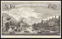
Gesicht Van De Cingelverby de Kerk Van die van de Ausburgische confessie naar Ian Roonpoorts toren tot Amsterdam.: View of the Singel canal in Amsterdam as viewed from the Prins Hendrikkade Fossa Cingens; Confessionis Augustanae Remplum transiens, Johannis que de porta rubra turrim respiciens Amstelaedamum.
by SCHENK, Jan [after] RADEMAKER, Abraham
- Used
- Condition
- Used
- Quantity Available
- 1
- Seller
-
London, United Kingdom
- Item Price
-
$4,434.03$18.84 shipping to USA
Show Details
Description:
Amsterdam,: Leonard Schenk,, [c1720].. 558 by 950mm (22 by 37.5 inches).. Engraving with etching, on two sheets joined. The most prominent feature of the of this view is The Ronde Lutherse Kerk or Koepelkerk is a former Lutheran church. The church was built in neo-classical style and has a characteristic copper dome. It was built in 1671 by Dutch Golden Age architect Adriaan Dortsman, who also built Museum Van Loon, a magnificent private residence at the Keizersgracht. When the Lutherans left the building in 1935, it became a concert hall. In 1993 the interior and characteristic green-colored copper dome were destroyed by fire. After a renovation period of 16 months, the church was fully restored. Further down the canal the imposing Roonports tower can be seen. Leonard Schenk (fl.1720-1746) an Jan Schenk (1698-1752) were brothers working as engravers and publisher's in Amsterdam. Abraham Rademaker (1677 21 January 1735) was an 18th-century painter and printmaker from the Northern Netherlands.…
Read More Item Price
$4,434.03
$18.84
shipping to USA
Gesigt van den Vermaakelyken Overtoom: View of the Overtoom Gelegen buyten de Leydsche Poort der Stad Amsterdam te sien naar de groote en kleyne overhaal. Vüe agreable de l'overtoom, hors de la porte de leide, pres de la ville d'astersdam
by SCHENK, Leon; [after] RADEMAKER, Abraham
- Used
- Condition
- Used
- Quantity Available
- 1
- Seller
-
London, United Kingdom
- Item Price
-
$4,710.38$18.84 shipping to USA
Show Details
Description:
Amsterdam,: Leon Schenk, Abraham Rademaker,, [c1720].. 560 by 960mm. (22 by 37.75 inches).. Engraving with etching, on two sheets joined. A view of the Overtoom in the eighteenth century. By the eighteenth century numerous country villas had been built along the Overtoom, one of the main canal's linking Amsterdam with river Schinkel, as well as pleasure gardens and numerous ale houses and shops. The Overtoom gained its name from the machine for moving a boat from one body of water to another where the level varied. Rather than with the aid of a lock, in other canal systems, the boat would be physically pulled across the land. The machine is depicted to the right of the print, consisting of two large wheels, it can be seen pulling a small boat onto the canal. Leonard Schenk (fl.1720-1746) engraver, mapmaker, and publisher in Amsterdam. Abraham Rademaker (1677 21 January 1735) was an 18th-century painter and printmaker from the Northern Netherlands. Rademaker was born in Lisse. According to the…
Read More Item Price
$4,710.38
$18.84
shipping to USA
Gesigt van den Vermaakelyken Overtoom Gelegen buyten de Leydsche Poort der Stad Amsterdam te sien naar de groote en kleyne Overhaal.: View of the Overtoom
by SCHENK, Leonard; RADEMAKER, Abraham
- Used
- Condition
- Used
- Quantity Available
- 1
- Seller
-
London, United Kingdom
- Item Price
-
$4,898.79$18.84 shipping to USA
Show Details
Description:
[Amsterdam,: Leonard Schenk,, c1720].. 550 by 960mm (21.75 by 37.75 inches).. Etching with engraving, on two sheets joined. A view of the Overtoom in the eighteenth century. By the eighteenth century numerous country villas had been built along the Overtoom, one of the main canal's linking Amsterdam with river Schinkel, as well as pleasure gardens and numerous ale houses and shops. The Overtoom gained its name from the machine for moving a boat from one body of water to another where the level varied. Rather than with the aid of a lock, in other canal systems, the boat would be physically pulled across the land. The machine is depicted to the right of the print, consisting of two large wheels, it can be seen pulling a small boat onto the canal. Proof before letters, with part of title in manuscript in a contemporary hand. Leonard Schenk (fl.1720-1746) engraver, mapmaker, and publisher in Amsterdam. Abraham Rademaker (1677 21 January 1735) was an 18th-century painter and printmaker from the…
Read More Item Price
$4,898.79
$18.84
shipping to USA

Nova totius Asiae tabula.: Schenk's rare wall map of Asia, known in only one other example
by SCHENK, Petrus
- Used
- Condition
- Used
- Quantity Available
- 1
- Seller
-
London, United Kingdom
- Item Price
-
$144,451.50$18.84 shipping to USA
Show Details
Description:
Amsterdam,: Petrus Schenk Excudit. Met Previlegie P. Tideman deliavit G V Gouwen fecit,, [c1710].. 840 by 970mm. (33 by 38.25 inches).. Engraved wall map on 9 joined sheets, with contemporary hand-colour in outline. A magnificent wall map of all Asia, extending from the Mediterranean and Arabia in the west to the Pacific and Australia in the east. The title appears in a separate decorative banner along the top; five vignettes of city views are attached along the bottom. An inset double-hemisphere map of the world surrounded by an elaborate allegorical cartouche, based on Joan Blaeu's world map of 1648 (see Schilder, Shirley 371, and Wieder vol. 3) appears lower left. Schenk's map of Asia derives from Jan Mathysz's set of the continents published c1655 (see British Library), which were also based on Joan Blaeu's world map of 1648 (Shirley 371): one of the significant differences being that on the main map Korea appears as peninsula, whereas in the vignette it is an island. The town views are also…
Read More Item Price
$144,451.50
$18.84
shipping to USA

Didn’t find what you’re looking for?
Try adding this search to your want list. Millions of books are added to our site everyday and when we find one that matches your search, we’ll send you an email. Best of all, it’s free.
Add to Want List

Are you a frequent reader or book collector?
Join the Bibliophile's Club and save 10% on every purchase, every day — up to $20 savings per order!

Social Responsibility
Did you know that since 2004, Biblio has used its profits to build 16 public libraries in rural villages of South America?