Description:
London,: The Map Collectors Circle,, 1973.. Hardcover, 188 pages. A survey of the cartography of the British Isles, and a listing of 670 printed maps from 1477-1650.
Search Results: Titles starting with E from Daniel Crouch Rare Books Ltd
You searched for:
- Bookseller inventory: Daniel Crouch Rare Books Ltd (titles starting with E)
- Bookseller: Daniel Crouch Rare Books Ltd
Results 1 - 20 of 24

More Photos
Early Printed Maps of the British Isles, A Bibliography, 1477-1650: Shirley's cartobibliography of the British Isles
by SHIRLEY, Rodney
- Used
- Hardcover
- Condition
- Used
- Binding
- Hardcover
- Quantity Available
- 1
- Seller
-
London, United Kingdom
- Item Price
-
$252.30$18.92 shipping to USA
Show Details
Item Price
$252.30
$18.92
shipping to USA

More Photos
Early Printed Maps of the British Isles, A Bibliography 1477-1650: Shirley's cartobibliography of the British Isles
by SHIRLEY, Rodney
- Used
- Hardcover
- Condition
- Used
- Binding
- Hardcover
- Quantity Available
- 1
- Seller
-
London, United Kingdom
- Item Price
-
$252.30$18.92 shipping to USA
Show Details
Description:
London,: The Holland Press Limited,, 1980.. Hardcover, 188 pages. History of the cartography of the British Isles, and list of 670 maps from 1477-1650.
Item Price
$252.30
$18.92
shipping to USA
![[Eight views of London]](https://d3525k1ryd2155.cloudfront.net/h/905/909/1162909905.0.m.jpg)
More Photos
[Eight views of London]: Eight views from a member of the Nuremberg Academy A View of Blackwall, looking towards Greenwich; A View of Sheperton; A View of the Tower, taken upon the Thames; A View taken near Limehouse Bridge, looking down the Thames; Greenwich Hospital; A View of
by HEUMANN, G[eorg]. D[aniel]
- Used
- Hardcover
- Condition
- Used
- Binding
- Hardcover
- Quantity Available
- 1
- Seller
-
London, United Kingdom
- Item Price
-
$4,036.80$18.92 shipping to USA
Show Details
Description:
Nuremberg,: G.D. Hermann,, [c1740].. (each) 350 by 480mm (13.75 by 19 inches).. Eight engraved prints. Eight prints showing Blackwall, Shepperton, the Tower of London, Limehouse, Greenwich Hospital, London Bridge, Battersea and Woolwich. Blackwall was an important shipping area in the Port of London. - Martin Frobisher's voyage to find the Northwest Passage began from Blackwall - and a key shipyard. A ship under construction is visible to the right of the print. Although business had declined in the early eighteenth century, Britain's involvement in the War of Jenkins's Ear and then the Austrian Succession revitalized business. It would be the largest private shipyard in the world by 1784. Shepperton was still an agricultural village, attracting writers and artists including Percy Shelley and Canaletto, who were inspired by the peaceful surroundings and the Thames. The Tower was no longer a royal residence when the print was made. The last monarch to stay there was Charles II before his coronation…
Read More Item Price
$4,036.80
$18.92
shipping to USA

The Elephant and Castle on the Road to Brighton.: The Elephant and Castle
by FIELDING, Theodore, after POLLARD, James
- Used
- Condition
- Used
- Quantity Available
- 1
- Seller
-
London, United Kingdom
- Item Price
-
$2,523.00$18.92 shipping to USA
Show Details
Description:
London,: Published by J. Watson, 7 Vere Street,, Feb. 7th, 1826.. Image: 540 by 766mm (21.25 by 30.25 inches). Sheet: 626 by 815mm (24.75 by 32 inches).. Engraving with aquatint and hand-colour. The Elephant and Castle Inn was a public house and busy staging post, probably deriving its name from the coat of arms of the Cutler's Guild, which feature an elephant as a nod to the use of ivory in cutlery handles. It gives its name to the present area of London. There are a variety of vehicles going past the inn, including a private coach, stage coaches going to Bognor and Brighton, and a wagon. Museum of London 002039.
Item Price
$2,523.00
$18.92
shipping to USA

Empire of Japan.: Map of Japan by Aaron Arrowsmith
by ARROWSMITH, Aaron
- Used
- Condition
- Used
- Quantity Available
- 1
- Seller
-
London, United Kingdom
- Item Price
-
$296.45$18.92 shipping to USA
Show Details
Description:
London,: Longman, Hurst, Rees, & Orme, Paternoster Row,, 1807.. 275 by 420mm. (10.75 by 16.5 inches).. Double-page engraved map. Finely engraved map of Japan by Aaron Arrowsmith, the leading British cartographer of his day. The map shows rivers, mountains, gold mines, towns, and cities. Fatsitio (Hachij -jima) is marked 'Fatsisio, or Unhappy I. The Place of Exile for the Japanese Grandees.' The interior of Korea has been left blank, except for a scale in British and Japanese miles.
Item Price
$296.45
$18.92
shipping to USA

The Empire of Japan with part of the Continent of Asia.: A map of Japan by Edward Weller from the 'Weekly Dispatch Atlas' showing the River Amoor and the new boundary between the Russian & Chinese Territories, by Edward Weller F.R.G.S.
by WELLER, Edward
- Used
- Condition
- Used
- Quantity Available
- 1
- Seller
-
London, United Kingdom
- Item Price
-
$189.23$18.92 shipping to USA
Show Details
Description:
London,, 1858.. 500 by 335mm. (19.75 by 13.25 inches).. Chromolithograph map, green stamp. A map of Japan by Edward Weller, from the 'Weekly Dispatch Atlas', an atlas published in monthly instalments from 1855 for subscribers to John Cassell's newspaper 'The Weekly Dispatch'. Edward Weller (1819-1884) was a British engraver and cartographer, and pioneered the production of lithographed maps.
Item Price
$189.23
$18.92
shipping to USA

The Empire of Japan with part of the Continent of Asia: The Empire of Japan with part of the Continent of Asia showing the River Amoor and the new boundary between the Russian & Chinese Territories, by Edward Weller F.R.G.S.
by WELLER, Edward
- Used
- Condition
- Used
- Quantity Available
- 1
- Seller
-
London, United Kingdom
- Item Price
-
$189.23$18.92 shipping to USA
Show Details
Description:
London,: Engraved by Edwd. Weller, Duke Street, Bloomsbury,, [c1858].. 480 by 330mm (19 by 13 inches).. Chromolithograph map. A map of Japan by Edward Weller, from the 'Weekly Dispatch Atlas', an atlas published in monthly instalments from 1855 for subscribers to John Cassell's newspaper 'The Weekly Dispatch'. Edward Weller (1819-1884) was a British engraver and cartographer, and pioneered the production of lithographed maps.
Item Price
$189.23
$18.92
shipping to USA

The Engraving of the First Carriage, the "Ariel",: The first aeroplane? is respectfully inscribed to the Directors of the Aerial Transit Company, by their obedient Servants, The Publishers.
by WALTON, W.L.
- Used
- Condition
- Used
- Quantity Available
- 1
- Seller
-
London, United Kingdom
- Item Price
-
$1,450.73$18.92 shipping to USA
Show Details
Description:
[London,: W. Ackermann & Co., Strand,, 1842].. Image: 229 by 305mm (9 by 12 inches). Sheet: 285 by 320mm (11.25 by 12.5 inches).. Lithograph, trimmed at lower edge. The 'Ariel' was a flying machine patented in 1842 by William Henson and John Stringfellow, an early type of aeroplane and an important step in the transition from glider-type aircraft to ones powered by engines. Together with Frederick Marriott and D.E. Columbine, they formed the Aerial Transit Company to raise money for its construction. They foresaw a glorious future for their invention: they wanted "to convey letters, goods and passengers from place to place through the air". Unfortunately, however, the Ariel was incapable of sustained flight, since it had insufficient power from its heavy steam engine to fly. A more successful model was built in 1848 which was able to fly for small distances within a hangar. They were also plagued by public suspicions that the whole project was a hoax. W.L. Walton (fl.1834-55) was a British…
Read More Item Price
$1,450.73
$18.92
shipping to USA

The Entrance of Havannah.: Havana Harbour
by [Anonymous]
- Used
- Condition
- Used
- Quantity Available
- 1
- Seller
-
London, United Kingdom
- Item Price
-
$3,784.50$18.92 shipping to USA
Show Details
Description:
c1760.. 280 by 390mm. (11 by 15.25 inches).. Manuscript map, in pen and ink en grisaille on paper. View of the mouth of Havana Harbour taken from a shipboard vantage point, emphasising the two forts that guarded the mouth: on the left the 'Castillo de los Tres Reyes Magos del Morro' (Morro Castle) and on the right 'Castillo de San Salvador de la Punta, and marking the boom chain barrier stretched between the two. Havana was attacked by the British towards the end of the Seven Years' War, and this would seem an appropriate date for this image. Seeing that Morro Castle presented a formidable challenge should it be attacked from the seaward, the British simply landed troops on Cuba who approached from the landward side, and commenced siege operations on 11th June, gradually battering the walls into ruin. A breach was made on 30th July and the castle taken by storm. With the key to its defences lost, Havana was quickly compelled to surrender.
Item Price
$3,784.50
$18.92
shipping to USA

Erster Herausgeber des grossen Atlas von Frankreich. geb. zu Paris d.17 Junÿ 1714, gest, d,4 Sept. 1784.
by WESTERMAYER, C[onrad]; [after] [Jean Henri] CLESS
- Used
- first
- Condition
- Used
- Quantity Available
- 1
- Seller
-
London, United Kingdom
- Item Price
-
$378.45$18.92 shipping to USA
Show Details
Description:
[Weimar,: Friedrich Justin Bertuch,, c1808].. 140 by 90mm. (5.5 by 3.5 inches).. Prints,""César-François Cassini de Thury Cesar-Francois Cassini Stipple-engraved portrait. César-François Cassini de Thury (1714-1784) came from and continued a line of astronomers, with his grandfather, father and son all studying and observing the movements and positions of celestial bodies. In 1744, he began the construction of a huge topographical map of France, one of the landmarks in the history of French cartography, which was posthumously published in 180 sheets by his son. Cassini appeared in an issue of the 'Allgemeine geographische Ephemeriden', the geographical journal published by Zach and Bertuch, in 1808. His portrait was engraved by German draughtsman Westermayer after a portrait by French artist Jean Henri Cless. Cassini's bust is shown in three-quarter perspective; he is wearing a powdered wig and voluminous robes. Beneath the oval containing the image German text identifies him as """"Erster…
Read More Item Price
$378.45
$18.92
shipping to USA
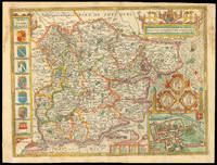
Essex,: Rare Roger Rea edition of Speed's map of Essex devided into Hundreds, with the most antient and fayre Towne Colchester Described and other memorable Monuments observed.
by SPEED, John
- Used
- Condition
- Used
- Quantity Available
- 1
- Seller
-
London, United Kingdom
- Item Price
-
$2,144.55$18.92 shipping to USA
Show Details
Description:
[London],: to be solde by Roger Rea ye elder & younger at ye Golden Crosse in Cornhill agt. ye Exchang,, 1665.. 410 by 550mm. (16.25 by 21.75 inches).. Double-page engraved map, fine contemporary outline hand colour, upper left and right margins skilfully repaired, margins reinforced with japan paper. The map bears the imprint of Roger Rea the Elder and Younger. The Reas had purchased the rights to Speed's work from William Garrett in 1659, who had previously purchased them from the widow of William Humble in the same year. Skelton suggests that the father and son intended a new edition of the atlas for the Restoration of 1660. However, the atlas would appear not to have been published until 1665. This is borne out by an advertisement in the Term Catalogue by the subsequent owners of the plates, Thomas Bassett and Richard Chiswell, in 1675: "Mr John Speed's... Geography of the Kingdoms of England, Scotland, and Ireland... together with his Prospect... all in one entire Volume, hath been, for seven…
Read More Item Price
$2,144.55
$18.92
shipping to USA
![[Essex] A Diary and Plan of the Siege of Colchester,](https://d3525k1ryd2155.cloudfront.net/h/323/910/1162910323.0.m.jpg)
[Essex] A Diary and Plan of the Siege of Colchester,: Rare broadsheet of the Siege of Colchester by the Parliament Forces, under the Command of General Fairfax, 1648.
- Used
- Condition
- Used
- Quantity Available
- 1
- Seller
-
London, United Kingdom
- Item Price
-
$1,513.80$18.92 shipping to USA
Show Details
Description:
Colchester,: W. Keymer,, [c1790].. 400 by 580mm. (15.75 by 22.75 inches).. Broadside engraved map set within five columns of printed historical text. A broadsheet with an account of the siege of Colchester during the Second English Civil War, which lasted from 12th June to 27th August 1648, from a Parliamentary persepctive. Royalist armies under Lord Capel, Lord Norwich and Lord Loughborough had been driven out of Kent, through Essex, and into Colchester, where they were besieged by General Fairfax's Parliamentarian forces. So many buildings were destroyed that at one point in the siege the Cavaliers took refuge behind the ruined walls of St Botolph's Priory. The people of Colchester, who had in general supported the Parliamentarian cause, demanded that the Roundhead solders allow supplies through or allow them to leave the town, but Fairfax refused. The army ate their horses (a local butcher gained fame after refusing to kill the animals) and commandeered the rapidly dwindling supplies; the…
Read More Item Price
$1,513.80
$18.92
shipping to USA
![[Essex] Essexiae comitat](https://d3525k1ryd2155.cloudfront.net/h/111/507/1391507111.0.m.jpg)
[Essex] Essexiae comitat: The first printed map of Essex nova vera ac absoluta descriptio An. Dnu. 1576
by SAXTON, Christopher
- Used
- Condition
- Used
- Quantity Available
- 1
- Seller
-
London, United Kingdom
- Item Price
-
$3,153.75$18.92 shipping to USA
Show Details
Description:
London,: Christopher Saxton, , 1579. . 420 by 550mm. (16.5 by 21.75 inches).. Double-page engraved map, fine original full-wash colour, contemporary annotation on verso in brown ink. In 1575, Christopher Saxton was authorised by the Queen's Privy Council to survey and map the counties of England and Wales, a task which he had completed by 1579, when the resulting maps were compiled and published in his seminal Atlas of England and Wales. This map of Essex is one of the 35 maps included in the atlas, and the first county map of Essex ever to be produced. It records the county's landscape and settlements, represented by small illustrations of Churches, enclosed parklands, rivers, bridges, and the occasional hill. Details of the surrounding counties, labelled with their Latin names, are also included, most prominently London, represented by a mass of buildings, intricately illustrated. Saxton has also expressed certain features of Essex which would be of interest to the crown, such as the Blockhouse…
Read More Item Price
$3,153.75
$18.92
shipping to USA

Europa, ad magnae Europae Gerardi Mercatoris: Mercator's map of Europe with the imaginary island of Frisland P. imitationem, Rumoldi Mercatoris F. cura edita, servato tamen initio longitudinis ex ratione magnetis, quod Pater in magna sua universali posuit
by MERCATOR, Rumold; Gerald MERCATOR
- Used
- Condition
- Used
- Quantity Available
- 1
- Seller
-
London, United Kingdom
- Item Price
-
$1,829.18$18.92 shipping to USA
Show Details
Description:
[Duisberg,, 1595].. 388 by 515mm. (15.25 by 20.25 inches).. Double page engraved map with contemporary colour. With no text on back. Top edge trimmed to image, bottom edge trimmed to neat line. This very fine map of Europe is from Mercator's 'Atlas sive Cosmographicae Meditationes de Fabrica Mundi et Fabricati Figura,' first published in 1595. This rare early edition with the ornate strapwork cartouche was only used until 1606 when the cartouche was changed. The geography on the map relates to Mercator's wall map of the world in 1569. There are a number of fictitious elements to the map that originated with the Venetian Nicolo Zeno from 1558. According to Zeno's map, his noble ancestors Nicolò and Antonio had discovered America in the 15th centur,y prior to Columbus, but ended up stranded on an island called Frisland (Frislant), south of Iceland, which does not exist. Mercator included Zeno's information on his maps and due to his esteemed reputation, the inaccuracies continued to appear on…
Read More Item Price
$1,829.18
$18.92
shipping to USA

An Exact Plan of His Majesty's Great Roads Through the Highlands of Scotland.: Lead up to the Battle of Prestonpans To the Honourable Charles Leslie This Plan of His Majesty's Great Roads Through the Highlands of Scotland is Dedicated by Sir Your most Obedt. Humble Servt. And: Rutherford.
by RUTHERFORD, Andrew
- Used
- Condition
- Used
- Quantity Available
- 1
- Seller
-
London, United Kingdom
- Item Price
-
$9,461.25$18.92 shipping to USA
Show Details
Description:
London,: Publish'd according to Act of Parliament,, Decr. 9th, 1745.. 523 by 352mm. (20.5 by 13.75 inches).. Large engraved broadsheet map, fine original hand-colour, inset plan of the Battle of Prestonpans, text below. Rare broadsheet map of the southern Highlands, centred on the region between Inverness in the north and Edinburgh in the south, illustrating the marches and counter-marches of the Hanoverian and Jacobite armies leading up to the battle of Prestonpans when the Highland army won a crushing victory over the King's forces. The base map was drawn by Rutherford from the journal of a gentleman who worked on General Wade's military road-building between 1726 and 1737. We have only been able to trace two other examples of this map: the (damaged) example in the National Library of Scotland, and another, with modern colour, in a private collection in Kent. NLS Newman 1152(2).
Item Price
$9,461.25
$18.92
shipping to USA
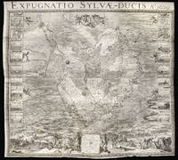
Expugnatio Sylvae-Ducis Ao 1629.: The Siege of the Swamp Dragon
by NIELS, Theodoor; SAVERIJ, Salomon [engraved figures after] VENNE, Adriaan van de; BERCKENRODE, Balthasar Florensz van [engraved map]
- Used
- Condition
- Used
- Quantity Available
- 1
- Seller
-
London, United Kingdom
- Item Price
-
$113,535.00$18.92 shipping to USA
Show Details
Description:
[Amsterdam],: H.J. Van Wouw,, 1631.. 1274 by 1405mm. (50.25 by 55.25 inches).. Engraved wall map on six sheets joined, eighteen inset views of the battle and siege works to left and right of the map. Large separately published six sheet map of the Siege of 's-Hertogenbosch during the Eighty Years War. Hostilities between the Habsburg Empire and the Dutch Republic resumed in 1621, following the ending of the Twelve Years' Truce. The Habsburgs tried to punish the rebellious Dutch Republic by cutting it off from its hinterland by a land blockade. The blockade caused an economic crisis for the Republic and it reacted by trying to harm Spain in its colonies. In 1628, one of the many schemes undertaken met with spectacular success when Admiral Piet Hein of the Dutch West India Company captured the Spanish treasure fleet. With this windfall from the Stadtholder Frederick Henry decided to break the Habsburg blockade by launching a campaign against 's-Hertogenbosch. 's-Hertogenbosch, also known as moerasdraak…
Read More Item Price
$113,535.00
$18.92
shipping to USA

e Topografiche.
by MAGGI, Giovanni Battista
- Used
- Condition
- Used
- Quantity Available
- 1
- Seller
-
London, United Kingdom
- Item Price
-
$1,513.80$18.92 shipping to USA
Show Details
Description:
Turin and Florence,, [c1862].. 214 by 156mm. (8.5 by 6.25 inches).. Books,""Catalogo di alcune fra le migliori e piu' recenti carte geografiche Book supplier to the King of Italy Octavo pamphlet, 21pp., index, 1 blank. Unrecorded edition of one of the very rare stock lists of Giovanni Battista Maggi, an Italian publisher and trader of maps, who later became a famous photographer. He was the official supplier of books and maps to his majesty Victor Emanuel II of Italy, as indicated on the title-page: """"provveditore di stampe di s[ua] m[aesta]"""". The catalogue contains a large number of maps of countries from all over the world, with a large selection of maps of Italy, but also notable selections of Germany, Asia, America and France. Apparently only a few of the maps were published by Maggi himself. One of the maps of Italy by Sagansan bears the date 1862, so the present inventory was probably issued around the same time, as is confirmed by several other maps, such as Andriveau Goujon's 'Carte…
Read More Item Price
$1,513.80
$18.92
shipping to USA

entre lesquelles sont Sumatra, Iava, Borneo, &c.
by SANSON, Nicolas
- Used
- Condition
- Used
- Quantity Available
- 1
- Seller
-
London, United Kingdom
- Item Price
-
$693.82$18.92 shipping to USA
Show Details
Description:
[Utrecht,: Johannes Ribbius and Simon de Vries, , 1682-1683].. 215 by 290mm. (8.5 by 11.5 inches).. Maps,""Les Isles de la Sonde, Singapore as part of the mainland Engraved map. Detailed map of western Southeast Asia, including the Malay Peninsula, Sumatra, Java and Borneo. Showing """"Sinca=pura"""" as part of the mainland. First published in 'L'Asie en Plusieurs Cartes...' (1652) engraved by A. Peyrounin. Johannes Ribbius and Simon de Vries published a German edition in 1682 and 1683, with new maps engraved by Antoine d'Winter, retaining the French captions on the maps. Nicolas Sanson (1600-1667) began to make maps to supplement his study of history, and a map of Ancient Gaul, made early in his career brought him to the attention of Cardinal Richelieu. This foothold in the French court allowed him to rise to the position of geographe du roi, teaching both Louis XIII and Louis XIV. Louis XIII even made him a counsellor of state. Sanson produced an atlas, 'Cartes Generales de Toutes les Parties…
Read More Item Price
$693.82
$18.92
shipping to USA
et Liqueurs de toutes especes, Boites à dragés pour Baptêmes et Mariages, ainsi que les objets d'etrennes.
by [ANONYMOUS]
- Used
- Condition
- Used
- Quantity Available
- 1
- Seller
-
London, United Kingdom
- Item Price
-
$756.90$18.92 shipping to USA
Show Details
Description:
[Paris,, nineteenth century].. (diamter) 160mm (6.25 inches).. Prints,""Magasin de Bonbons, Chocolats, Confitures, Sirops C is for Chocolatier Engraved trade card. The present print appears to be not a trade card but a product label, similar in design and shape to many of those found on food products in nineteenth century France. There is a blank rectangle where the contents of the package could be written by hand, and beneath this is a sentence clarifying that the goods come from a """"sweet, chocolate, jam, syrup and liqueur shop"""" (trans.). It also advertises that they can provide such delights for celebrations including baptisms and marriage. Indeed the image at the centre of the print appears to show a newly married couple leaving the church, both elaborately dressed and attended by a small boy and bridesmaid. The whole label is surrounded by a decorative floral frame.
Item Price
$756.90
$18.92
shipping to USA
et insularum adiacentium ex intima antiquitate chorographica descriptio.
by CAMDEN, William
- Used
- first
- Condition
- Used
- Quantity Available
- 1
- Seller
-
London, United Kingdom
- Item Price
-
$20,184.00$18.92 shipping to USA
Show Details
Description:
London,: Published by [printed at Eliot's court press] impensis Georg. Bishop,, 1600.. Atlases,""Britannia, sive florentissimorum regnorum Angliae, Scotiae, Hiberniae, A fine example of Camden's Britannia in a contemporary binding Quarto (202 by 142mm), engraved frontispiece by W. Rogers, two folding engraved maps, several engraved illustrations in text, a few full or double page, a few central leaves lightly age browned, very occasional light marginal foxing, fine contemporary French red morocco binding, triple-fillet border, gilt-stamped armorial supralibros on covers, monogram and title gilt on spine compartments. Collation: pp. [16], 831, [27], 30, [2], [2] pls. A finely bound copy of the first survey of Great Britain county by county and the first study of Roman Britain as perceived in the landscape of sixteenth century Britain. The present copy is in the fifth edition, with dedication to Queen Elizabeth, and is the first to include maps. William Camden (1551-1623) was an English…
Read More Item Price
$20,184.00
$18.92
shipping to USA

Didn’t find what you’re looking for?
Try adding this search to your want list. Millions of books are added to our site everyday and when we find one that matches your search, we’ll send you an email. Best of all, it’s free.
Add to Want List

Are you a frequent reader or book collector?
Join the Bibliophile's Club and save 10% on every purchase, every day — up to $20 savings per order!

Social Responsibility
Did you know that since 2004, Biblio has used its profits to build 16 public libraries in rural villages of South America?