Description:
NY: Benedikt Taschen, 1992. First Printing; thus; pictorial wraps; 16+76 (plates, clean, unmarked pages/index.. 1st. Paperback. Near Fine. Illus. by M. C. Escher. folio.
Search Results: Titles starting with M from Dorley House Books
You searched for:
- Bookseller inventory: Dorley House Books (titles starting with M)
- Bookseller: Dorley House Books
Results 1 - 20 of 4159

M. C. Escher: The Graphic Work (Explained and Introduced By The Artist
by Escher, M. C. (Maurits Cornelis)
- Used
- near fine
- Paperback
- first
- Condition
- Used - Near Fine
- Edition
- 1st
- Binding
- Paperback
- ISBN 13
- 9783822896341
- ISBN 10
- 3822896349
- Quantity Available
- 1
- Seller
-
Hagerstown, Maryland, United States
- Item Price
-
$8.95$7.20 shipping to USA
Show Details
Item Price
$8.95
$7.20
shipping to USA

MAP : "Positions & Connections of Telegraphic Longitude Stations" ...from Coast & Geodetic Survey Report, 7/1/1908 to 6/30/09
by United States Department of Commerce and Labor
- Used
- very good
- Paperback
- first
- Condition
- Used - Very Good
- Edition
- 1st
- Binding
- Paperback
- Quantity Available
- 1
- Seller
-
Hagerstown, Maryland, United States
- Item Price
-
$35.00$7.20 shipping to USA
Show Details
Description:
Washington D.C.: Government Printing Office, 1909. 24" x 30"; telegraph map on the US in 1909. 1st. Unbound. Very Good. Illus. by Red, b/w Map. 24" x 30".
Item Price
$35.00
$7.20
shipping to USA
More Photos
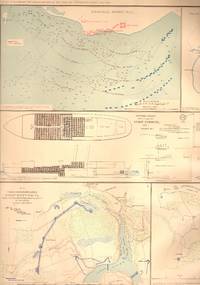
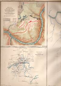
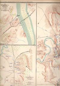
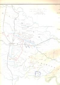
MAP: 10 maps-inc Federal Point, Fort Fisher, NC; Petersburg, Deep Bottom, Harrison's Landing and Crows Nest, Virginia--1864
by United States War Department
- Used
- very good
- Paperback
- Condition
- Used - Very Good
- Binding
- Paperback
- Quantity Available
- 1
- Seller
-
Hagerstown, Maryland, United States
- Item Price
-
$85.00$7.20 shipping to USA
Show Details
Description:
Washington D.C.: Government Printing Office, 1891. Plae #LXVII (67) from the Atlas to Accompany the Official Records of the Union & Confederate Armies, 1861-1865...Single sheet suitable for framing [2 scans = almost full image]. Unbound. Very Good. Illus. by Handcolored. 18" x 29".
Item Price
$85.00
$7.20
shipping to USA
More Photos
MAP: 12 Section Map, Including Maps of Campaigns from Savannah, Georgia to Goldsborough, North Carolina and also Taylor's Store, Alabama ,
by United States War Department
- Used
- very good
- Paperback
- first
- Condition
- Used - Very Good
- Edition
- 1st
- Binding
- Paperback
- Quantity Available
- 1
- Seller
-
Hagerstown, Maryland, United States
- Item Price
-
$95.00$7.20 shipping to USA
Show Details
Description:
Washington, D.C.: Government Printing Office, 1891. 1st thus edition; Plate LXXX...From the Atlas to Accompany the Official Records of the Union and Confederate Armies, 1861-1865..single sheet, lovely, and suitable for framing [2 sans=almost full image]. 1st. Unbound. Very Good. Illus. by Colored Map. 18" x 29".
Item Price
$95.00
$7.20
shipping to USA

MAP: 14 Sketches, and Maps of Battles of Chickamauga, Georgia, Bristoe Station, Manassas Junction, Fort Creighton, Chattanooga, Tennessee, Fort Jones, Cleveland, Tennessee, Fort Phelps, Etc
by United States War Department
- Used
- near fine
- Paperback
- Condition
- Used - Near Fine
- Binding
- Paperback
- Quantity Available
- 1
- Seller
-
Hagerstown, Maryland, United States
- Item Price
-
$75.00$7.20 shipping to USA
Show Details
Description:
Washington, D.C.: Government Printing Office, 1891. Plate CXI, From the Atlas to Accompany the Official Records of the Union & Confederate Armies, 1861-1865. ; Lovely, and suitable for framing. Unbound. Near Fine. Illus. by Colored Map. 18" x 29".
Item Price
$75.00
$7.20
shipping to USA
More Photos
MAP: 15 maps and sketches of 16th & 17th Army positions, 1864
by United States War Department
- Used
- near fine
- Paperback
- first
- Condition
- Used - Near Fine
- Edition
- 1st
- Binding
- Paperback
- Quantity Available
- 1
- Seller
-
Hagerstown, Maryland, United States
- Item Price
-
$95.00$7.20 shipping to USA
Show Details
Description:
Washington D.C.: Government Printing Office, 1891. Plate #LXI (60) from the Atlas to Accompany the Official Records of the Union & Confederate Armies, 1861-1865....Single sheet suitable for framing. 1st. Unbound. Near Fine. Illus. by Colored & b&w Photos. 18" x 29".
Item Price
$95.00
$7.20
shipping to USA

MAP: "1st & 2nd Wards of Hagerstown, Maryland"...from An Illustrated Atlas of Washington County, Maryland
by Lake, Grinning & Stevenson
- Used
- very good
- Paperback
- first
- Condition
- Used - Very Good
- Edition
- 1st
- Binding
- Paperback
- Quantity Available
- 1
- Seller
-
Hagerstown, Maryland, United States
- Item Price
-
$175.00$7.20 shipping to USA
Show Details
Description:
Philadelphia: Lake, Grinning & Stevenson, 1877. 16" x 28" colored map (as shown in image) locates some businesses, residences and owners; railroads; cemeteries, etc.; seam repair at lower edge. 1st. Unbound. Very Good. Illus. by Colored Map. 28" x 16".
Item Price
$175.00
$7.20
shipping to USA
MAP: 2 maps--Seige of Atlanta, GA & Operations Map of the Army Under Commands o f Maj. Gen. W.T. Sherman in Georgia. 18864
by United States War Department
- Used
- very good
- Paperback
- Condition
- Used - Very Good
- Binding
- Paperback
- Quantity Available
- 1
- Seller
-
Hagerstown, Maryland, United States
- Item Price
-
$75.00$7.20 shipping to USA
Show Details
Description:
Washington D.C.: Government Printing Office, 1891. Plate #LXXXVIII..., From the Atlas to Accompany the Official Records of the Union & Confederate Armies, 1861-1865 . Unbound. Very Good. Illus. by Handcolored. 18" x 29".
Item Price
$75.00
$7.20
shipping to USA

MAP: "22,500 Acres of Land Owned By the London Land Company in New Castle County..." from Pennsylvania Archives, Third Series, Appendix I-X
by Egle, William Henry (Editor)
- Used
- very good
- Paperback
- Condition
- Used - Very Good
- Binding
- Paperback
- Quantity Available
- 1
- Seller
-
Hagerstown, Maryland, United States
- Item Price
-
$55.00$7.20 shipping to USA
Show Details
Description:
Harrisburg, PA: Clarence M. Busch, State Printer, 1894. ...lovely and ready to frame...1894 reprint of a survey map from 1736, showing property owned by Laetitia Penn, John Evans, Reece Thomas, Thomas Pierson, Robert French, White Clay Creek, Peter Britton, Joseph Pennock, Thomas Fairman , London Land company. Unbound. Very Good. Illus. by Colored Fold-out Map. 9.5" x 15".
Item Price
$55.00
$7.20
shipping to USA

MAP: " 279A: Corbin Area, Kootenay District, British Columbia" from Geological Survey of Canada, "A" Series
by Geological Survey of Canada
- Used
- very good
- Paperback
- first
- Condition
- Used - Very Good
- Edition
- 1st
- Binding
- Paperback
- Quantity Available
- 1
- Seller
-
Hagerstown, Maryland, United States
- Item Price
-
$48.00$7.20 shipping to USA
Show Details
Description:
Ottawa, Canada: Canadian Department of Mines, 1931. 29.5" x 23"colored geological map; scale 1" = 100. 1st. Unbound. Very Good. Illus. by Multicoloured Geological Map. 29.5" x 23".
Item Price
$48.00
$7.20
shipping to USA
More Photos
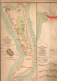
MAP: 3 Section Maps of the Battle Plan and Final Attack of Fort Fisher , North Carolina
by United States War Department
- Used
- very good
- Paperback
- first
- Condition
- Used - Very Good
- Edition
- 1st
- Binding
- Paperback
- Quantity Available
- 1
- Seller
-
Hagerstown, Maryland, United States
- Item Price
-
$85.00$7.20 shipping to USA
Show Details
Description:
Washington, D.C.: Government Printing Office, 1891. First Thus printing; Plate LXXV....From the Atlas to Accompany the Official Records of the Union and Confederate Armies, 1861-1865..single sheet, lovely, and suitable for framing [2 scans = almost full image]. 1st. Unbound. Very Good. Illus. by Colored Map. 18" x 29".
Item Price
$85.00
$7.20
shipping to USA
More Photos
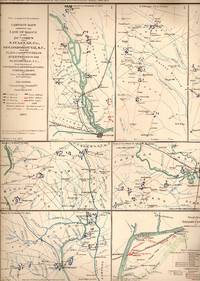
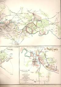
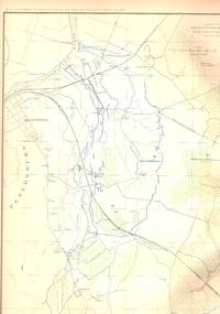
MAP: 3 Section Map, Including Military Reconnaissance Vicinity of Gauley Bridge, Department of Western Virginia; Sketch of the Country About Somerset Kentucky, & Map of the Battlefield of Carnifix Ferry, Gauley River, West Virgiinia
by United States War Department
- Used
- very good
- Paperback
- first
- Condition
- Used - Very Good
- Edition
- First Thus
- Binding
- Paperback
- Quantity Available
- 1
- Seller
-
Hagerstown, Maryland, United States
- Item Price
-
$75.00$7.20 shipping to USA
Show Details
Description:
Washington, D.C.: Government Printing Office, 1891. Plate #IX (9) from the Atlas to Accompany the Official Records of the Union and Confederate Armies, 1861-1865..single sheet, LOVELY and suitable for framing [2 scans = almost full image]. First Thus. Unbound. Very Good. Illus. by Colored Map. 18" x 29".
Item Price
$75.00
$7.20
shipping to USA

MAP: "315 1/2 Acres Called Coxburg..." from Pennsylvania Archives, Third Series, Appendix I-X
by Egle, William Henry (Editor)
- Used
- very good
- Paperback
- Condition
- Used - Very Good
- Binding
- Paperback
- Quantity Available
- 1
- Seller
-
Hagerstown, Maryland, United States
- Item Price
-
$55.00$7.20 shipping to USA
Show Details
Description:
Harrisburg, PA: Clarence M. Busch, State Printer, 1894. ...lovely and ready to frame...1894 reprint of a survey map from 1780, showing with survey notations, an area of 315 1/2 acres called Coxbury with property owned around it by Samuel Irwin, Robert Lytle, & Robert Estep. Unbound. Very Good. Illus. by Colored Fold-out Map. 9.5:" x 14".
Item Price
$55.00
$7.20
shipping to USA

MAP: "3rd Ward of Hagerstown (Maryland)"...from An Illustrated Atlas of Washington County, Maryland
by Lake, Griffing & Stevenson Company
- Used
- very good
- Paperback
- first
- Condition
- Used - Very Good
- Edition
- 1st
- Binding
- Paperback
- Quantity Available
- 1
- Seller
-
Hagerstown, Maryland, United States
- Item Price
-
$150.00$7.20 shipping to USA
Show Details
Description:
Philadelphia: Lake, Griffing & Stevenson Company, 1877. 13" x 16.25" colored maps; Scale 2oo feet=1". 1st. Unbound. Very Good. Illus. by Colored Map. 13" x 16.25".
Item Price
$150.00
$7.20
shipping to USA
More Photos
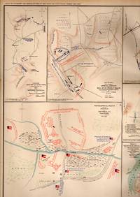
MAP: 4 Maps & 2 Sketches: Topographical Sketch of Fortress Rosecrans Near Murfreesborough, Tenn.; Etc
by United States War Department
- Used
- very good
- Paperback
- first
- Condition
- Used - Very Good
- Edition
- 1st
- Binding
- Paperback
- Quantity Available
- 1
- Seller
-
Hagerstown, Maryland, United States
- Item Price
-
$95.00$7.20 shipping to USA
Show Details
Description:
Washington D.C.: Government Printing Office, 1891. Plate #CXII from the Atlas to Accompany the Official Records of the Union & Confederate Armies, 1861-1865. single sheet suitable for framing; 1st printing of this atlas; [2 scans = almost full image]. 1st. Unbound. Very Good. Illus. by Handcolored. 18" x 29".
Item Price
$95.00
$7.20
shipping to USA
More Photos
MAP: 4 Section Map, Including the Rappahannock River, Jackson, Mississippi, operations of the Army of the Potomac, Etc
by United States War Department
- Used
- very good
- Paperback
- first
- Condition
- Used - Very Good
- Edition
- 1st
- Binding
- Paperback
- Quantity Available
- 1
- Seller
-
Hagerstown, Maryland, United States
- Item Price
-
$85.00$7.20 shipping to USA
Show Details
Description:
Washington, D.C.: Government Printing Office, 1891. Plate #XXXIX (39) from the Atlas to Accompany the Official Records of the Union and Confederate Armies, 1861-1865... 1st. Unbound. Very Good. Illus. by Colored Map. 18" x 29".
Item Price
$85.00
$7.20
shipping to USA
More Photos
MAP: 4 Section Map, Including Artillery Positions Of the Army of the Potomac, Reconnaissance Beyond the Chickahominy, Petersburg, Virginia
by United States War Department
- Used
- very good
- Paperback
- first
- Condition
- Used - Very Good
- Edition
- 1st
- Binding
- Paperback
- Quantity Available
- 1
- Seller
-
Hagerstown, Maryland, United States
- Item Price
-
$75.00$7.20 shipping to USA
Show Details
Description:
Washington, D.C.: Government Printing Office, 1891. First Thus printing; Plate #LXIV (64) from the Atlas to Accompany the Official Records of the Union and Confederate Armies, 1861-1865..single sheet suitable for framing [2 scans = almost full image]. 1st. Unbound. Very Good. Illus. by Colored Map. 18" x 29".
Item Price
$75.00
$7.20
shipping to USA
More Photos
MAP: 4 maps of the Battle-grounds of Richmond and Williamsburg Virginia, 1861-1862
by United States War Department
- Used
- very good
- Paperback
- first
- Condition
- Used - Very Good
- Edition
- 1st
- Binding
- Paperback
- Quantity Available
- 1
- Seller
-
Hagerstown, Maryland, United States
- Item Price
-
$75.00$7.20 shipping to USA
Show Details
Description:
Washington D.C.: Government Printing Office, 1891. 1st thus printing; Plate #XX (20) from the Atlas to Accompany the Official Records of the Union & Confederate Armies, 1861-1865....Single sheet suitable for framing [2 scans = almost full image]. 1st. Unbound. Very Good. Illus. by Handcolored. 18" x 29".
Item Price
$75.00
$7.20
shipping to USA

MAP: "405 1/2 Acres of Mt. Pleasant..." from Pennsylvania Archives, Third Series, Appendix I-X
by Egle, William Henry (Editor)
- Used
- very good
- Paperback
- Condition
- Used - Very Good
- Binding
- Paperback
- Quantity Available
- 1
- Seller
-
Hagerstown, Maryland, United States
- Item Price
-
$55.00$7.20 shipping to USA
Show Details
Description:
Harrisburg, PA: Clarence M. Busch, State Printer, 1894. ...lovely and ready to frame...1894 reprint of a survey map from 1785, showing with survey notations an area of 405 1/2 acres called Mt. Pleasant.... Unbound. Very Good. Illus. by Colored Fold-out Map. 9.5:" x 14".
Item Price
$55.00
$7.20
shipping to USA

MAP: "418 1/2 Acres for Bazil Brown..." from Pennsylvania Archives, Third Series, Appendix I-X
by Egle, William Henry (Editor)
- Used
- very good
- Paperback
- Condition
- Used - Very Good
- Binding
- Paperback
- Quantity Available
- 1
- Seller
-
Hagerstown, Maryland, United States
- Item Price
-
$55.00$7.20 shipping to USA
Show Details
Description:
Harrisburg, PA: Clarence M. Busch, State Printer, 1894. ...lovely and ready to frame...1894 reprint of a survey map from 1785, showing with survey notations, an area of 418 1/2 acres belonging to Bazil Brown, assignee of Wm. Colvin, and with property owned around it by Thomas Brown Senc, Thomas Smith, Thomas Brown, Henry Devoir, & Otho Beashears. Unbound. Very Good. Illus. by Colored Fold-out Map. 9.5:" x 14".
Item Price
$55.00
$7.20
shipping to USA

Didn’t find what you’re looking for?
Try adding this search to your want list. Millions of books are added to our site everyday and when we find one that matches your search, we’ll send you an email. Best of all, it’s free.
Add to Want List

Are you a frequent reader or book collector?
Join the Bibliophile's Club and save 10% on every purchase, every day — up to $20 savings per order!

Social Responsibility
Did you know that since 2004, Biblio has used its profits to build 16 public libraries in rural villages of South America?