Skip to content

Search Results: Titles starting with S from Original Antique Maps

You searched for:
  • Bookseller inventory: Original Antique Maps (titles starting with S)
  • Bookseller: Original Antique Maps
Results 1 - 6 of 6
Savannah Fast  Freight Lines Map, c. 1884
More Photos

Savannah Fast Freight Lines Map, c. 1884

  • Used
Condition
Used
Quantity Available
1
Seller
FRAMINGHAM, Massachusetts, United States
Seller rating:
This seller has earned a 5 of 5 Stars rating from Biblio customers.
Item Price
$325.00
$11.00 shipping to USA

Show Details

Description:
Details:black ink on yellow paper, double sided printingcondition: conserved, good condition, remnants of stain in lower section of map Description:The Savannah Fast Freight Lines map, 1884 is printed on the verso of the Bill of Lading dated Dec. 18, 1884 for Douglas Axe Mfg. Co. of East Douglas, Massachusetts (1837-1897)1/ dated in manuscript that appears to read 1884. Business headquarters were in Boston, a shipping hub. The Bill of Lading makes this document original source material for 19th c. shipping to and from the American South. One useful aspect of the map is for the shipper's clients to see the actual travel route of their goods. The Douglas Axe Mfg. Co. goods were to be delivered by steamer to Savannah, Georgia.
The Great Southern Freight Line via the Ocean Steamship Company and Central Railroad of Georgia operated between 1872 and 1951. The line provided a reliable route north for southern products, such as cotton. In this particular instance, the Central Massachusetts based… Read More
Item Price
$325.00
$11.00 shipping to USA
School Girl Atlas Maps, Set of 5, Signed [Manuscript]  c.1840
More Photos

School Girl Atlas Maps, Set of 5, Signed [Manuscript] c.1840: from Mitchell's School and Family Geography, c.1840 as "drawn by H.M. Pearson"

  • Used
Condition
Used
Quantity Available
1
Seller
FRAMINGHAM, Massachusetts, United States
Seller rating:
This seller has earned a 5 of 5 Stars rating from Biblio customers.
Item Price
$1,000.00
$11.00 shipping to USA

Show Details

Description:
Details:School Girl Manuscript Atlas Maps c.1840 drawn in ink and fine pencil, signed H. M. Pearson:
Oceanica, dimensions: 10 ¾" x 7 ½"
Africa, dimensions: 10 1/4" x 8"
So. America, dimensions: 8" x 10.5"
Europe, dimensions: 10 3/8" x 8"
Asia, dimensions: 10.5" x 8"condition: as found good original condition, the art work is in very good condition, toning in margins of wove paper, some minor marginal chips, traces of red wax in marginDescription:This set of five (5) manuscript maps, drawn in a fine point pencil and ink pen on medium size sheets of paper, are exceptional hand work by a school girl working from Mitchell's School and Family Geography, 1839 copyright edition and most likely published as the 1840 edition. The maps have been drawn with a steady and disciplined hand. The outlines of the continents and countries, the stippling, lettering and details and the overall grid of longitude and latitude faithfully capture the original, engraved color maps. In fact, at first glance, the pencil… Read More
Item Price
$1,000.00
$11.00 shipping to USA
A Set of 15 Engraved Charts from the United States Exploring Expedition. During the Years...
More Photos

A Set of 15 Engraved Charts from the United States Exploring Expedition. During the Years 1838,1839,1840,1841,1842.: Under the Command of Charles Wilkes, U.S.N. By Authority of Congress. Philadelphia Atlas of Charts. VOL. I. and VOL. II From the Surveys of the Expedition.

by United States Exploring Expedition (U.S.Ex.Ex.)

  • Used
Condition
Used
Quantity Available
1
Seller
FRAMINGHAM, Massachusetts, United States
Seller rating:
This seller has earned a 5 of 5 Stars rating from Biblio customers.
Item Price
$17,000.00
$11.00 shipping to USA

Show Details

Description:
Details:black and white engraved charts on heavy paper, a printed oval stamp with Navy anchor and "U.S.Ex.Ex.", and "Price thirteen cents" on each single-page chartengravers: G.W. Boynton, J. Knight, George G. Smith, Sherman & Smith, and unsignedprinter: Conger Sherman, Philadelphia
dimensions: 26 1/2" x 19 1/2" approx., sheet sizecondition: professionally conserved, good condition
Description: Chart InventoryPlease see www.spackantiquemaps.com for the complete essay. Essay footnotes only below.

II. Lot of 15 Charts on Offer: Alphabetical by Island GroupFiji Archipelago:
Whippy Harbour South Side of Viti Levu By The U.S.Ex.Ex. 1840.; Suva Harbour South Side of Viti Levu By The U.S.Ex.Ex. 1840.; , Granby Harbour South Side of Viti Levu By The U.S.Ex.Ex. 1840.; Ndronga Harbor South Side of Viti Levu By The U.S. Ex.Ex. 1840. [one sheet, four maps of different views of Viti Levu largest island of the Fiji nation]26 ½ x 19 ½ inchesno engraver's namepaper toned, edge… Read More
Item Price
$17,000.00
$11.00 shipping to USA
The Singing Bird or Progressive Music Reader 1853
More Photos

The Singing Bird or Progressive Music Reader 1853

by William B. Bradbury

  • Used
Condition
Used
Quantity Available
1
Seller
FRAMINGHAM, Massachusetts, United States
Seller rating:
This seller has earned a 5 of 5 Stars rating from Biblio customers.
Item Price
$150.00
$11.00 shipping to USA

Show Details

Description:
details:mid-19th century singing and song book with seller's and owner's book platesdimensions: 7 3/4" x 5 1/4" x 5/8"
condition: good original condition, front cover professionally reinforced at hinge Description:This volume of The Singing Bird or Progressive Music Reader, 1853 is inscribed in faint pencil that appears to be "Mary Whitneys" "Boston, Mass. 1855" on the top right corner of the inside free end paper. The book's yellow decorated paper board cover is printed with the music for the song "The Wild Bird's Song" in keeping with the educator's philosophy that vocal music is the student's goal. The rear cover of the book is printed with a publisher's advertisement of titles.
There is the music bookseller's yellow paper bookplate inside the front cover. Please see photograph. The music book was sold from Andrew Whitney's Piano Forte Carhart's Patent Seraphine, Aeolian and Melodian Ware-Room on Main Street in Fitchburg, Worcester County, Massachusetts. The book owner and the book seller may… Read More
Item Price
$150.00
$11.00 shipping to USA
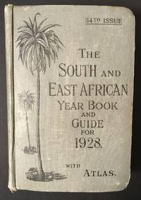
The South and East African Year Book Guide. With Atlas and Diagrams. 34th Issue owned by A. Jessop
More Photos

The South and East African Year Book Guide. With Atlas and Diagrams. 34th Issue owned by A. Jessop: Union-Castle Atlas pp. 2-64 with color maps, single and double page, George Philips & Son, Geographical Institute, London

by Edited Annually By A. Samler Brown, F.R.M.S. & G. Gordon Brown, F.R.G.S.

  • Used
  • Hardcover
  • Signed
Condition
Used
Edition
34th
Binding
Hardcover
Quantity Available
1
Seller
FRAMINGHAM, Massachusetts, United States
Seller rating:
This seller has earned a 5 of 5 Stars rating from Biblio customers.
Item Price
$275.00
$11.00 shipping to USA

Show Details

Description:
Contents and Condition:Union-Castle Atlas pp. 2-64 with color maps, single and double page, George Philips & Son, Geographical Institute, London
"Advertisements South Africa, Capetown with East Africa Route", pp. 1-129.
dimensions: 7 3/8" x 5 1/2" x 1 5/8"
condition: decorated fabric covers show mild wear, binding tight, front cover attached with weakening at bottom of binding
owner's name in manuscript ink on title page: "A.Jessop Coronado, California, U.S.A"Description:
This densely informative travel guide was owned by A. Jessop of Coronado, California. The A. Jessop who owned this book is most likely a son of Joseph Edward Jessop, an English watchmaker and jewelry store owner who with his wife emigrated from London, England to California, seeking to settle in the San Diego area with their children. The Jessop family established a jewelry store that became multi-generational in the San Diego, California area. In 1901 the Jessop family moved to Coronado, California. In 1907, Mr. Jessop… Read More
Item Price
$275.00
$11.00 shipping to USA
Superior-Quetico [Minnesota-Ontario] Canoe Maps, 1952, lot of 5
More Photos

Superior-Quetico [Minnesota-Ontario] Canoe Maps, 1952, lot of 5

by W.A. Fisher

  • Used
Condition
Used
Quantity Available
1
Seller
FRAMINGHAM, Massachusetts, United States
Seller rating:
This seller has earned a 5 of 5 Stars rating from Biblio customers.
Item Price
$300.00
$11.00 shipping to USA

Show Details

Description:
Map Details:color printed, double sided guide maps on crinkled, waxed papercondition: good, as found, working maps, some with original fold lines, occasional edge wearDimensions: 20 3/4" x 15 3/4"Map Descriptions:
Superior-Quetico [Minnesota-Ontario] Canoe Maps, 1952, lot of 5:No. 104 Jean-Pickerel LakesNo. 107 Crane-Sand Point Point-Lac La CroixNo. 108 Crooked-Agnes LakesNo. 1112 Burntside-Basswood LakesNo. 113 Moose-Knife-Insula LakesThe Superior-Quetico Wilderness straddles the Minnesota-Canada border. The map key and map notes describe this region as a 14,500 mile "wilderness empire" and labyrinth of connecting lakes. A boundary chain of lakes extends 2,000 miles westerly from Lake Superior to International Falls. Another route called The Hunter's Island Route runs north into Canada for 60 miles. The map states (and warns) "The wilderness is only accessible by canoe and pack." The purpose of the W.A.Fisher canoe maps is to permit planning a canoe trip to this vast wilderness of lakes, falls and… Read More
Item Price
$300.00
$11.00 shipping to USA
Add to Want List

Didn’t find what you’re looking for?

Try adding this search to your want list. Millions of books are added to our site everyday and when we find one that matches your search, we’ll send you an email. Best of all, it’s free.

Add to Want List
Book lovers can save on books by joining our Bibliophiles club

Are you a frequent reader or book collector?

Join the Bibliophile's Club and save 10% on every purchase, every day — up to $20 savings per order!

Biblio is a socially responsible company

Social Responsibility

Did you know that since 2004, Biblio has used its profits to build 16 public libraries in rural villages of South America?