Description:
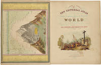
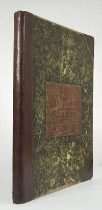
Philadelphia: Thomas, Cowperthwait & Co., 1852. Chromolithographic title with large vignette; handcolored frontispiece of heights of principal mountains and lengths of principal rivers; contents list printed in red, black, and gold; seventy-three handcolored lithographic maps, charts, and city plans (one double-page). Folio. Publisher's three-quarter red morocco and marbled boards, spine ruled in gilt, morocco label lettered in gilt on front board. Binding worn and rubbed, front hinge tender. Contemporary bookplate on front pastedown. Some toning but generally clean internally. Very good overall. A famous atlas, with handcolored maps of all the individual states and territories, with the map of California showing counties in California and New Mexico for the first time, and with the locations of Native American tribes shown in several western states and territories. Despite its title, the atlas concentrates to a marked degree on the American continent, with forty-three maps of the area, including a…
Read More A NEW UNIVERSAL ATLAS CONTAINING MAPS OF THE VARIOUS EMPIRES, KINGDOMS, STATES AND REPUBLICS OF THE WORLD, WITH A SPECIAL MAP OF EACH OF THE UNITED STATES, PLANAS OF CITIES, COMPREHENDED IN SEVENTY SHEETS ..... by MITCHELL, S. AUGUSTUS, JR - 1846
by MITCHELL, S. AUGUSTUS, JR
Similar copies are shown below.
Similar copies are shown to the right.

A NEW UNIVERSAL ATLAS CONTAINING MAPS OF THE VARIOUS EMPIRES, KINGDOMS, STATES AND REPUBLICS OF THE WORLD, WITH A SPECIAL MAP OF EACH OF THE UNITED STATES, PLANAS OF CITIES, COMPREHENDED IN SEVENTY SHEETS .....
by MITCHELL, S. AUGUSTUS, JR
- Used
- Hardcover
- first
Philadelphia: S. Augustus Mitchell, Jr., 1846. Marbled paper-covered boards with sres of missing paper at front fore-edge. (See photo). Front cover leather label with left 2" missing. A total of seventy-one hand-colored plates with 117 maps, plans, and sections. Edges darkened with light foxing, never heavy or obtrusive. All maps are printed on the rectos, versos blank. Beautiful vignette title-page with plate numbered 72 as frontispiece, "Heights of Principal Mountains In The World". All maps are intact and in excellent condition, collated complete. The map of North America has old tape repair at left margin, with browning of the tape. (Photo). List of previous owners starting in 1847 on front free endpaper, four listed. A very well-preserved copy of this first edition of Mitchell's atlas. . First Edition. 1/2 Red Morocco. Moderate Cover Wear/No Dudst Jacket. Folio, 14 1/2" x 16 1/2".
-
Bookseller
Glenn Books
 (US)
(US)
- Format/Binding Hardcover
- Book Condition Used - Moderate Cover Wear
- Jacket Condition No Dudst Jacket
- Quantity Available 1
- Edition First Edition
- Binding Hardcover
- Publisher S. Augustus Mitchell, Jr.
- Place of Publication Philadelphia
- Date Published 1846
- Keywords Maps, Atlas, Hand-Colored Maps
- Size Folio, 14 1/2" x 16 1/2"
We have 2 copies available starting at $7,500.00.
More Photos
A NEW UNIVERSAL ATLAS CONTAINING MAPS OF THE VARIOUS EMPIRES, KINGDOMS, STATES AND REPUBLICS OF THE WORLD. WITH A SPECIAL MAP OF EACH OF THE UNITED STATES, PLANS OF CITIES, &c
by [Mitchell, S. Augustus]
- Used
- Hardcover
- Condition
- Used
- Binding
- Hardcover
- Quantity Available
- 1
- Seller
-
New Haven, Connecticut, United States
- Item Price
-
$7,500.00
Show Details
Item Price
$7,500.00
More Photos
New Universal Atlas of the World: Containing Maps of the various Empires, Kingdoms, States and Republics Of The World. With a special map of each of the United States, Plans of Cities &c. Comprehended in seventy sheets and forming a series of One Hundred And Seventeen Maps, Plans And Sect
by MITCHELL, S. Augustus
- Used
- Condition
- Used
- Quantity Available
- 1
- Seller
-
Beverly Hills, California, United States
- Item Price
-
$7,500.00
Show Details
Description:
Philadelphia: Cowperthwait & Co, 1852. Complete with seventy-three full colored maps, one of which is double-paged, color frontispiece, vignette title-page and table of contents, heightened in gilt. Folio (17 x 14 inches; 430 x 355 mm). Half red morocco over marbled boards. Front board with red morocco label, lettered in gilt. Binding scuffed and bumped. Hinges professionally repaired. Some toning throughout, mainly to blank versos of maps and margin edges, only occasionally affecting the maps. Closed tear to front free endpaper. A few instances of foxing on maps, mainly to map 51 "Holland and Belgium." A small dark spot in Buenos Ayres on map 44. A small piece scraped off of map 73, "Oceana" but not making a hole all the way through. Also a marginal closed tear to this map, professionally repaired. Overall a very good copy. This atlas was first published in 1846 by Mitchell & Sons after acquiring the rights to Tanner's New Universal Atlas in 1845. Mitchell & Sons reprinted it several times until…
Read More Item Price
$7,500.00