Description:
ca 1769.. Size 12.5 x 9.5 inches. In black wood frame with gilt border. Map size 11.25 x 8.5 inches. In very good condition. Small chip top left corner of frame. Original engraved map with later hand colouring. Map of the county of Breconshire from around 1769. Shows roads, towns, villages, rivers and hundreds. With illustrated title cartouche.
An Accurate Map of BERKSHIRE Divided Into Its Hundreds by Rollos, G - 1769
by Rollos, G

An Accurate Map of BERKSHIRE Divided Into Its Hundreds
by Rollos, G
- Used
- Paperback
London: Russell and Price, 1769. Single page map of BERKSHIRE [G. Rollos]. Published in ENGLAND DISLAYED Being a New, Complete, and Accurate Survey and Description of the Kingdom of England and Principality of Wales. Plate 16x20 cm [sheet 243 x 160mm]. VG original map printed on laid paper. Uncoloured. 2ND EDITION pub. 1769.. OTHER COUNTIES ARE AVAILABLE FROM THIS ISSUE..[Please email thomasrarebooks@btinternet.com]. Original Map. map. V.g.. 4to. Small Folio.
-
Bookseller
Independent bookstores
 (GB)
(GB)
- Format/Binding Paperback
- Book Condition Used - V.g.
- Edition Original Map
- Binding Paperback
- Publisher Russell and Price
- Place of Publication London
- Date Published 1769
- Size 4to
- Size 4to

An Accurate Map of Brecknockshire, (Breconshire) Divided into its Hundreds, by G.Rollos, Geographer.
by ROLLOS, G.:
- Used
- Condition
- Used
- Quantity Available
- 1
- Seller
-
Dorchester, Dorset, United Kingdom
- Item Price
-
$44.34
Show Details
Item Price
$44.34

More Photos
An Accurate Map of Brecknockshire, (Breconshire) Divided into its Hundreds, by G.Rollos, Geographer.
by ROLLOS, G.:
- Used
- Condition
- Used
- Quantity Available
- 1
- Seller
-
Dorchester, Dorset, United Kingdom
- Item Price
-
$48.14
Show Details
Description:
ca 1769.. Size 15.5 x 12.5 inches. In black wood frame with gilt border. Wide ivory mount. Map size 11.5 x 8.5 inches. In very good condition. Slight darkening to left side and lower right corner. Original engraved map with later hand colouring. Map of the county of Breconshire from around 1769. Shows roads, towns, villages, rivers and hundreds. With illustrated title cartouche.
Item Price
$48.14
An Accurate Map of Persia
by Rollos G
- Used
- Condition
- Used
- Quantity Available
- 1
- Seller
-
Bonn, Germany
- Item Price
-
$162.75
Show Details
Description:
1773. 41x34cm. Blatt leicht gebraeunt und schmutzig. 2 Falten
Item Price
$162.75
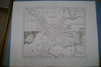
An Accurate map of Turkey in Asia
by Rollos G
- Used
- Condition
- Used
- Quantity Available
- 1
- Seller
-
Bonn, Germany
- Item Price
-
$170.34
Show Details
Description:
1773. kart 44x34.5cm. Blatt und fleckig. 2 Falten
Item Price
$170.34